

Acta Geodaetica et Cartographica Sinica ›› 2025, Vol. 54 ›› Issue (8): 1476-1488.doi: 10.11947/j.AGCS.2025.20240457
• Photogrammetry and Remote Sensing • Previous Articles Next Articles
Shuai FANG1,2( ), Jiaen LIU1, Jing ZHANG1
Received:2024-11-11
Revised:2025-06-19
Online:2025-09-16
Published:2025-09-16
About author:FANG Shuai (1978—), female, PhD, professor, majors in image restoration and visual inspection. E-mail: fangshuai@hfut.edu.cn
Supported by:CLC Number:
Shuai FANG, Jiaen LIU, Jing ZHANG. Spatio-temporal fusion algorithm based on adaptive reference feature incorporation and multi-scale feature aggregation[J]. Acta Geodaetica et Cartographica Sinica, 2025, 54(8): 1476-1488.

Fig. 1
The structure of the proposed algorithm"

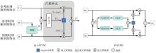
Fig. 2
The structure of adaptive reference feature incorporation module"

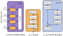
Fig. 3
Feature scale normalization block and multi-scale feature aggregation module structure"

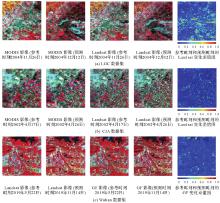
Fig. 4
Presention of the dataset"

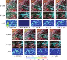
Fig. 5
The experimental results of each algorithm on the LGC dataset"

Tab. 1
Experimental results of each algorithm on LGC dataset"
| 算法 | RMSE↓ | SSIM↑ | SAM↓ | CC↑ |
|---|---|---|---|---|
| STARFM | 0.040 9 | 0.757 0 | 0.210 0 | 0.820 7 |
| FSDAF | 0.040 2 | 0.759 5 | 0.211 8 | 0.829 4 |
| STFDCNN | 0.033 5 | 0.806 9 | 0.160 8 | 0.873 9 |
| EDCSTFN | 0.032 7 | 0.811 3 | 0.159 9 | 0.880 8 |
| GAN-STFM | 0.033 4 | 0.811 7 | 0.164 5 | 0.878 7 |
| MLFF-GAN | 0.028 0 | 0.830 6 | 0.135 1 | 0.913 5 |
| 本文算法 | 0.026 5 | 0.847 9 | 0.123 6 | 0.923 2 |
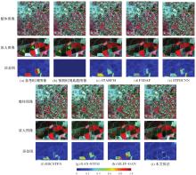
Fig. 6
The experimental results of each algorithm on the CIA dataset"

Tab. 2
Experimental results of each algorithm on CIA dataset"
| 算法 | RMSE↓ | SSIM↑ | SAM↓ | CC↑ |
|---|---|---|---|---|
| STARFM | 0.027 8 | 0.843 3 | 0.074 1 | 0.961 4 |
| FSDAF | 0.027 2 | 0.840 4 | 0.072 1 | 0.962 9 |
| STFDCNN | 0.026 5 | 0.854 5 | 0.067 2 | 0.963 6 |
| EDCSTFN | 0.023 9 | 0.871 0 | 0.060 0 | 0.970 4 |
| GAN-STFM | 0.026 4 | 0.858 2 | 0.072 4 | 0.964 0 |
| MLFF-GAN | 0.023 8 | 0.863 3 | 0.062 6 | 0.970 8 |
| 本文算法 | 0.023 1 | 0.874 8 | 0.059 1 | 0.972 6 |
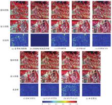
Fig. 7
The experimental results of each algorithm on the Wuhan dataset"

Tab. 3
Experimental results of each algorithm on Wuhan dataset"
| 算法 | RMSE↓ | SSIM↑ | SAM↓ | CC↑ |
|---|---|---|---|---|
| STARFM | 0.044 7 | 0.744 9 | 0.129 7 | 0.873 6 |
| FSDAF | 0.046 0 | 0.733 4 | 0.146 7 | 0.835 3 |
| STFDCNN | 0.018 6 | 0.893 5 | 0.064 1 | 0.955 9 |
| EDCSTFN | 0.018 5 | 0.901 9 | 0.074 6 | 0.962 0 |
| GAN-STFM | 0.019 5 | 0.888 6 | 0.084 3 | 0.954 2 |
| MLFF-GAN | 0.028 6 | 0.809 8 | 0.091 9 | 0.893 5 |
| 本文算法 | 0.014 7 | 0.918 6 | 0.048 1 | 0.971 6 |
Tab. 4
Quantitative evaluation of ablation experiment"
| 数据集 | 评价指标 | 去除AFIM | 去除MFAM | 去除FFL | 完整算法结构 |
|---|---|---|---|---|---|
| LGC | RMSE↓ | 0.027 7 | 0.026 7 | 0.026 5 | 0.026 5 |
| SSIM↑ | 0.839 0 | 0.844 3 | 0.846 5 | 0.847 9 | |
| SAM↓ | 0.130 4 | 0.127 9 | 0.124 6 | 0.123 6 | |
| CC↑ | 0.916 8 | 0.921 2 | 0.923 0 | 0.923 2 | |
| CIA | RMSE↓ | 0.023 3 | 0.023 8 | 0.023 4 | 0.023 1 |
| SSIM↑ | 0.870 8 | 0.868 1 | 0.871 8 | 0.874 8 | |
| SAM↓ | 0.061 7 | 0.062 2 | 0.059 9 | 0.059 1 | |
| CC↑ | 0.972 3 | 0.970 7 | 0.972 1 | 0.972 6 | |
| Wuhan | RMSE↓ | 0.015 7 | 0.016 3 | 0.015 5 | 0.014 7 |
| SSIM↑ | 0.888 9 | 0.905 0 | 0.913 9 | 0.918 6 | |
| SAM↓ | 0.057 8 | 0.055 6 | 0.052 8 | 0.048 1 | |
| CC↑ | 0.968 8 | 0.965 9 | 0.969 3 | 0.971 6 |
Tab. 5
Comparative experimental results of focal frequency loss and adversarial loss"
| 数据集 | 评价指标 | GANSTFM | FFLSTFM | MLFFGAN | MLFFFFL |
|---|---|---|---|---|---|
| LGC | RMSE↓ | 0.033 4 | 0.033 2 | 0.028 0 | 0.027 0 |
| SSIM↑ | 0.811 7 | 0.812 9 | 0.830 6 | 0.838 5 | |
| SAM↓ | 0.164 5 | 0.159 4 | 0.135 1 | 0.130 8 | |
| CC↑ | 0.878 7 | 0.880 1 | 0.913 5 | 0.919 0 | |
| CIA | RMSE↓ | 0.026 4 | 0.025 2 | 0.023 8 | 0.023 8 |
| SSIM↑ | 0.858 2 | 0.861 6 | 0.863 3 | 0.867 6 | |
| SAM↓ | 0.072 4 | 0.063 6 | 0.062 6 | 0.061 9 | |
| CC↑ | 0.964 0 | 0.967 2 | 0.970 8 | 0.971 0 | |
| Wuhan | RMSE↓ | 0.019 5 | 0.016 2 | 0.028 6 | 0.026 7 |
| SSIM↑ | 0.888 6 | 0.893 1 | 0.809 8 | 0.817 3 | |
| SAM↓ | 0.084 3 | 0.060 9 | 0.091 9 | 0.084 2 | |
| CC↑ | 0.954 2 | 0.961 7 | 0.893 5 | 0.906 8 |

Fig. 8
Comparison experiment of adversarial loss and focal frequency loss"

Tab. 6
Parameters and multiply-accumulate operations of spatio-temporal fusion methods"
| 方法 | 参数量 | MACs |
|---|---|---|
| STFDCNN | 0.087×10⁶ | 5.459×10⁹ |
| EDCSTFN | 0.284×10⁶ | 18.585×10⁹ |
| 本文算法 | 3.243×10⁶ | 12.192×10⁹ |
| GAN-STFM | 0.583×10⁶(生成器参数) | 37.760×10⁹ |
| 3.666×10⁶(鉴别器参数) | ||
| MLFF-GAN | 5.925×10⁶(生成器参数) | 17.369×10⁹ |
| 2.776×10⁶(鉴别器参数) |
| [1] |
张良培, 何江, 杨倩倩, 等. 数据驱动的多源遥感信息融合研究进展[J]. 测绘学报, 2022, 51(7): 1317-1337. DOI: .
doi: 10.11947/j.AGCS.2022.20220171 |
|
ZHANG Liangpei, HE Jiang, YANG Qianqian, et al. Data-driven multi-source remote sensing data fusion: progress and challenges[J]. Acta Geodaetica et Cartographica Sinica, 2022, 51(7): 1317-1337. DOI: .
doi: 10.11947/j.AGCS.2022.20220171 |
|
| [2] | LI Jun, LI Yunfei, HE Lin, et al. Spatio-temporal fusion for remote sensing data: an overview and new benchmark[J]. Science China Information Sciences, 2020, 63(4): 140301. |
| [3] | ZHU Xiaolin, CAI Fangyi, TIAN Jiaqi, et al. Spatiotemporal fusion of multisource remote sensing data: literature survey, taxonomy, principles, applications, and future directions[J]. Remote Sensing, 2018, 10(4): 527. |
| [4] |
黄波, 赵涌泉. 多源卫星遥感影像时空融合研究的现状及展望[J]. 测绘学报, 2017, 46(10): 1492-1499. DOI: .
doi: 10.11947/j.AGCS.2017.20170376 |
|
HUANG Bo, ZHAO Yongquan. Research status and prospect of spatiotemporal fusion of multi-source satellite remote sensing imagery[J]. Acta Geodaetica et Cartographica Sinica, 2017, 46(10): 1492-1499. DOI: .
doi: 10.11947/j.AGCS.2017.20170376 |
|
| [5] | 刘建波, 马勇, 武易天, 等. 遥感高时空融合方法的研究进展及应用现状[J]. 遥感学报, 2016, 20(5): 1038-1049. |
| LIU Jianbo, MA Yong, WU Yitian, et al. Review of methods and applications of high spatiotemporal fusion of remote sensing data[J]. Journal of Remote Sensing, 2016, 20(5): 1038-1049. | |
| [6] | GAO Feng, MASEK J, SCHWALLER M, et al. On the blending of the Landsat and MODIS surface reflectance: predicting daily Landsat surface reflectance[J]. IEEE Transactions on Geoscience and Remote sensing, 2006, 44(8): 2207-2218. |
| [7] | ZHU Xiaolin, CHEN Jin, GAO Feng, et al. An enhanced spatial and temporal adaptive reflectance fusion model for complex heterogeneous regions[J]. Remote Sensing of Environment, 2010, 114(11): 2610-2623. |
| [8] | ZHU Xiaolin, HELMER E H, GAO Feng, et al. A flexible spatiotemporal method for fusing satellite images with different resolutions[J]. Remote Sensing of Environment, 2016, 172: 165-177. |
| [9] | XU Chen, DU Xiaoping, YAN Zhenzhen, et al. VSDF: a variation-based spatiotemporal data fusion method[J]. Remote Sensing of Environment, 2022, 283: 113309. |
| [10] |
皮新宇, 曾永年, 王盼成. 面向非均质区域的空间增强型时空融合模型研究[J]. 测绘学报, 2023, 52(10): 1714-1723. DOI: .
doi: 10.11947/j.AGCS.2023.20220519 |
|
PI Xinyu, ZENG Yongnian, WANG Pancheng. Spatially enhanced spatio-temporal fusion model for heterogeneity regions[J]. Acta Geodaetica et Cartographica Sinica, 2023, 52(10): 1714-1723. DOI: .
doi: 10.11947/j.AGCS.2023.20220519 |
|
| [11] | HUANG Bo, SONG Huihui. Spatiotemporal reflectance fusion via sparse representation[J]. IEEE Transactions on Geoscience and Remote Sensing, 2012, 50(10): 3707-3716. |
| [12] | SONG Huihui, LIU Qingshan, WANG Guojie, et al. Spatiotemporal satellite image fusion using deep convolutional neural networks[J]. IEEE Journal of Selected Topics in Applied Earth Observations and Remote Sensing, 2018, 11(3): 821-829. |
| [13] | TAN Zhenyu, YUE Peng, DI Liping, et al. Deriving high spatiotemporal remote sensing images using deep convolutional network[J]. Remote Sensing, 2018, 10(7): 1066. |
| [14] | TAN Zhenyu, DI Liping, ZHANG Mingda, et al. An enhanced deep convolutional model for spatiotemporal image fusion[J]. Remote Sensing, 2019, 11(24): 2898. |
| [15] | LIU Xun, DENG Chenwei, CHANUSSOT J, et al. StfNet: a two-stream convolutional neural network for spatiotemporal image fusion[J]. IEEE Transactions on Geoscience and Remote Sensing, 2019, 57(9): 6552-6564. |
| [16] | YIN Zhixiang, WU Penghai, FOODY G M, et al. Spatiotemporal fusion of land surface temperature based on a convolutional neural network[J]. IEEE Transactions on Geoscience and Remote Sensing, 2021, 59(2): 1808-1822. |
| [17] | ZHANG Hongyan, SONG Yiyao, HAN Chang, et al. Remote sensing image spatiotemporal fusion using a generative adversarial network[J]. IEEE Transactions on Geoscience and Remote Sensing, 2021, 59(5): 4273-4286. |
| [18] | SONG Bingze, LIU Peng, LI Jun, et al. MLFF-GAN: a multilevel feature fusion with GAN for spatiotemporal remote sensing images[J]. IEEE Transactions on Geoscience and Remote Sensing, 2022, 60: 3169916. |
| [19] | SHANG Cheng, LI Xinyan, YIN Zhixiang, et al. Spatiotemporal reflectance fusion using a generative adversarial network[J]. IEEE Transactions on Geoscience and Remote Sensing, 2022, 60: 5400915. |
| [20] | SONG Yiyao, ZHANG Hongyan, HUANG He, et al. Remote sensing image spatiotemporal fusion via a generative adversarial network with one prior image pair[J]. IEEE Transactions on Geoscience and Remote Sensing, 2022, 60: 5528117. |
| [21] | TAN Zhenyu, GAO Meiling, LI Xinghua, et al. A flexible reference-insensitive spatiotemporal fusion model for remote sensing images using conditional generative adversarial network[J]. IEEE Transactions on Geoscience and Remote Sensing, 2022, 60: 3050551. |
| [22] | CHEN Jia, WANG Lizhe, FENG Ruyi, et al. CycleGAN-STF: spatiotemporal fusion via CycleGAN-based image generation[J]. IEEE Transactions on Geoscience and Remote Sensing, 2021, 59(7): 5851-5865. |
| [23] | CHEN Guanyu, JIAO Peng, HU Qing, et al. SwinSTFM: remote sensing spatiotemporal fusion using swin transformer[J]. IEEE Transactions on Geoscience and Remote Sensing, 2022, 60: 3182809. |
| [24] | LIN Liupeng, SHEN Yao, WU Jingan, et al. CAFE: a cross-attention based adaptive weighting fusion network for MODIS and Landsat spatiotemporal fusion[J]. IEEE Geoscience and Remote Sensing Letters, 2023, 20: 3286463. |
| [25] | JIANG Hao, QIAN Yurong, YANG Guangqi, et al. MLKNet: multi-stage for remote sensing image spatiotemporal fusion network based on a large kernel attention[J]. IEEE Journal of Selected Topics in Applied Earth Observations and Remote Sensing, 2024, 17: 1257-1268. |
| [26] | MA Yaobin, WANG Qi, WEI Jingbo. Spatiotemporal fusion via conditional diffusion model[J]. IEEE Geoscience and Remote Sensing Letters, 2024, 21: 5002405. |
| [27] | CHEN Guangsheng, LU Hailiang, DI Donglin, et al. StfMLP: spatiotemporal fusion multilayer perceptron for remote-sensing images[J]. IEEE Geoscience and Remote Sensing Letters, 2023, 20: 3230720. |
| [28] | XIAO Juan, AGGARWAL A K, DUC N H, et al. A review of remote sensing image spatiotemporal fusion: challenges, applications and recent trends[J]. Remote Sensing Applications: Society and Environment, 2023, 32: 101005. |
| [29] | HU Jie, SHEN Li, SUN Gang. Squeeze-and-excitation networks[C]//Proceedings of 2018 IEEE/CVF Conference on Computer Vision and Pattern Recognition. Salt Lake City: IEEE, 2018: 7132-7141. |
| [30] | JIANG Liming, DAI Bo, WU Wayue, et al. Focal frequency loss for image reconstruction and synthesis[C]//Proceedings of 2021 International Conference on Computer Vision. Montreal: IEEE, 2021: 13899-13909. |
| [31] | EMELYANOVA I V, MCVICAR T R, VAN NIEL T G, et al. Assessing the accuracy of blending Landsat-MODIS surface reflectances in two landscapes with contrasting spatial and temporal dynamics: a framework for algorithm selection[J]. Remote Sensing of Environment, 2013, 133: 193-209. |
| [32] | ZHANG Xingjian, XIE Linglin, LI Shuang, et al. Wuhan dataset: a high-resolution dataset of spatiotemporal fusion for remote sensing images[J]. IEEE Geoscience and Remote Sensing Letters, 2024, 21: 3432285. |
| [33] | ILYA L, FRANK H. SGDR: stochastic gradient descent with warm restarts[C]//Proceedings of 2017 International Conference on Learning Representations. Toulon: [s.n.], 2017. |
| [1] | Jiayao WANG, Lin CHEN, Shiyuan CHENG, Lijun WANG, Siqi XIONG. Artificial intelligence empowering the digital-intelligent transformation of cartographic science [J]. Acta Geodaetica et Cartographica Sinica, 2026, 55(3): 381-389. |
| [2] | Xiaomin LU, Zhiyi ZHANG, Haowen YAN, Yi HE, Xiaoning SU. A recognition method for building group pattern integrating deep graph infomax and multilayer perceptron [J]. Acta Geodaetica et Cartographica Sinica, 2026, 55(3): 425-438. |
| [3] | Shunping JI, Jin LIU, Jian GAO, Jianya GONG. An intelligent 3D reconstruction framework via deep learning based multi-view image matching [J]. Acta Geodaetica et Cartographica Sinica, 2025, 54(9): 1633-1646. |
| [4] | Jixian ZHANG, Haiyan GU, Huan NI, Haitao LI, Yi YANG, Shaopeng DING, Songman SUI. Deep learning methods for remote sensing intelligent change detection: evolution and development [J]. Acta Geodaetica et Cartographica Sinica, 2025, 54(8): 1347-1370. |
| [5] | Nina MENG, Fengmei LI, Xiaodong ZHOU. Data and cognition dual-driven building group generalization results and scale consistency assessment [J]. Acta Geodaetica et Cartographica Sinica, 2025, 54(7): 1318-1331. |
| [6] | Yaqing WANG, Zhonghui WANG. River network automated selection method based on heterogeneous graph convolutional networks [J]. Acta Geodaetica et Cartographica Sinica, 2025, 54(7): 1332-1345. |
| [7] | Xiaoya AN, Weiru GUO, Pengxin ZHANG, Xinxin LI, Lei SHI. Ship trajectories clustering method considering similarity in geometric position and mobility features [J]. Acta Geodaetica et Cartographica Sinica, 2025, 54(6): 1107-1121. |
| [8] | Chao WANG, Tianyu CHEN, Tong ZHANG, Tanvir AHMED, Liqiang JI, Tao XIE, Jiajun YANG, Shuai WANG. Multi-sensor optical remote sensing images change detection based on global differential enhancement module and balance penalty loss [J]. Acta Geodaetica et Cartographica Sinica, 2025, 54(5): 873-887. |
| [9] | Qingli LUO, Xueyan LI, Guoman HUANG, Honghui CHEN, Minglong XUE, Jian LI. AOSN: alpha optimal structure network for height estimation from a single SAR image in mountain areas [J]. Acta Geodaetica et Cartographica Sinica, 2025, 54(5): 888-898. |
| [10] | Wei TU, Xiangyuan CHI, Tianhong ZHAO, Jian YANG, Shiping ZHU, Deli CHEN. Multi-view spatio-temporal graph convolutional networks model for urban drainage networks flow prediction [J]. Acta Geodaetica et Cartographica Sinica, 2025, 54(2): 334-344. |
| [11] | Zhili ZHANG, Huiwei JIANG, Xiangyun HU. A minimal-interaction framework for accurate and batch extraction of geospatial objects from remote sensing imagery [J]. Acta Geodaetica et Cartographica Sinica, 2025, 54(10): 1863-1876. |
| [12] | Zhenghua ZHANG, Guoliang CHEN. A lightweight rotation-invariant network for LiDAR-based place recognition [J]. Acta Geodaetica et Cartographica Sinica, 2025, 54(1): 90-103. |
| [13] | Yan SHI, Da WANG, Min DENG, Xuexi YANG. Spatio-temporal anomaly detection: connotation transformation and implementation path from data-driven to knowledge-driven modeling [J]. Acta Geodaetica et Cartographica Sinica, 2024, 53(8): 1493-1504. |
| [14] | Xin YAN, Li SHEN, Junjie PAN, Yanshuai DAI, Jicheng WANG, Xiaoli ZHENG, Zhi-lin LI. Weakly supervised building change detection integrating multi-scale feature fusion and spatial refinement for high resolution remote sensing images [J]. Acta Geodaetica et Cartographica Sinica, 2024, 53(8): 1586-1597. |
| [15] | Jinwei BU, Kegen YU, Qiulan WANG, Linghui LI, Xinyu LIU, Xiaoqing ZUO, Jun CHANG. Deep learning retrieval method for global ocean significant wave height by integrating spaceborne GNSS-R data and multivariable parameters [J]. Acta Geodaetica et Cartographica Sinica, 2024, 53(7): 1321-1335. |
| Viewed | ||||||
|
Full text |
|
|||||
|
Abstract |
|
|||||