

Acta Geodaetica et Cartographica Sinica ›› 2024, Vol. 53 ›› Issue (7): 1321-1335.doi: 10.11947/j.AGCS.2024.20230050
• Marine Survey • Previous Articles Next Articles
Jinwei BU1( ), Kegen YU2(), Qiulan WANG1, Linghui LI1, Xinyu LIU1, Xiaoqing ZUO1, Jun CHANG3
Received:2023-02-22
Published:2024-08-12
Contact:
Kegen YU
E-mail:b_jinwei@kust.edu.cn;kegen.yu@cumt.edu.cn
About author:BU Jinwei (1992—), male, PhD, majors in GNSS-R. E-mail: b_jinwei@kust.edu.cn
Supported by:CLC Number:
Jinwei BU, Kegen YU, Qiulan WANG, Linghui LI, Xinyu LIU, Xiaoqing ZUO, Jun CHANG. Deep learning retrieval method for global ocean significant wave height by integrating spaceborne GNSS-R data and multivariable parameters[J]. Acta Geodaetica et Cartographica Sinica, 2024, 53(7): 1321-1335.
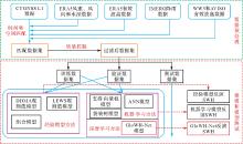
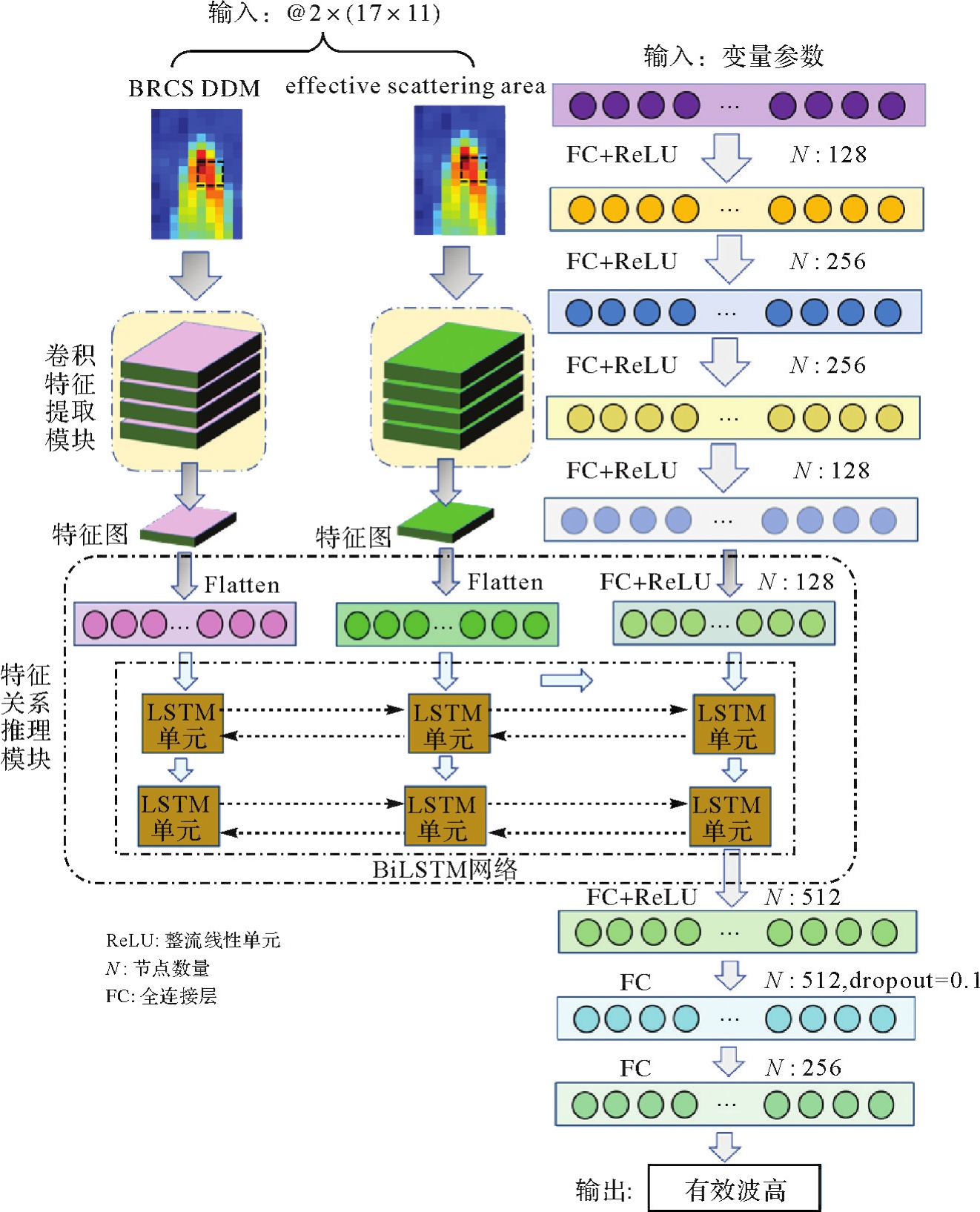
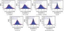
Data processing and model building process of spaceborne GNSS-R sea surface significant wave height retrieval"

Tab.1
Input parameter information of different models"
| 模型 | DDMs | 与DDM相关 | 与接收机相关 | 与几何相关 | 其他辅助参数 |
|---|---|---|---|---|---|
| BT/SVM | BRCS,effectivescattering area | DDMA,LES,TES,LEWS,TEWS,SNR | gps_eirp,sp_rx_gain | sp_inc_angle,sp_lat,sp_lon,RCG | 风速、风向、水深、降雨量 |
| ANN | — | ||||
| GloWH-Net | BRCS,effectivescattering area |
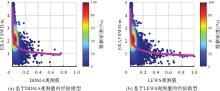
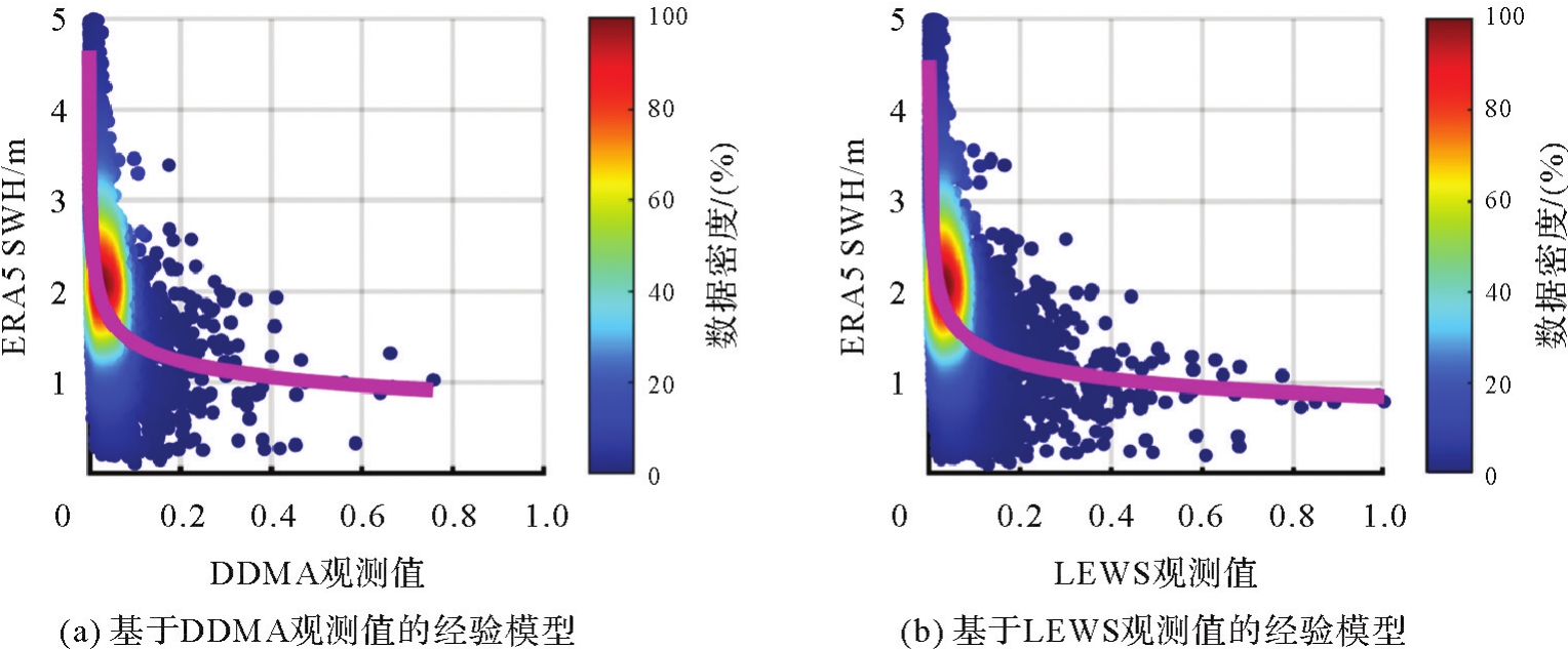
Empirical model for significant wave height retrieval based on DDMA and LEWS observables"
Tab.2
Fitting parameters and fitting performance of empirical models for significant wave height retrieval"
| 模型 | 拟合参数 | 拟合性能指标 | |||
|---|---|---|---|---|---|
| a | b | c | RMSE/m | R2 | |
| 经验模型(DDMA方法) | 0.953 3 | -0.204 9 | -0.094 5 | 0.712 | 0.25 |
| 经验模型(LEWS方法) | 0.857 0 | -0.228 7 | -0.013 9 | 0.709 | 0.26 |
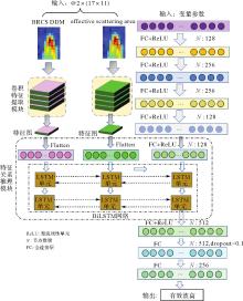
Architecture of GloWH-Net"
Tab.3
Accuracy of comparison between the significant wave height retrieved by different models on the test data set and ERA5 data"
| 模型 | RMSE/m | Bias/m | CC | MAPE/(%) |
|---|---|---|---|---|
| 经验模型(DDMA方法) | 0.715 | 0.004 | 0.49 | 31.18 |
| 经验模型(LEWS方法) | 0.709 | 0.001 | 0.51 | 30.78 |
| 经验模型(DDMA+LEWS方法) | 0.709 | 0.002 | 0.51 | 30.85 |
| BT | 0.423 | -0.013 | 0.85 | 15.14 |
| SVM | 0.564 | 0.047 | 0.72 | 22.00 |
| ANN | 0.455 | 0.001 | 0.83 | 16.75 |
| GloWH-Net | 0.330 | 0.032 | 0.91 | 12.19 |
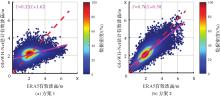
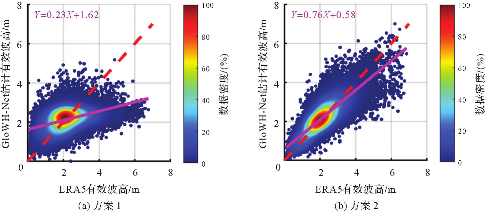
Fig.4
Scatter density plots of retrieved significant wave height by different models and ERA5 significant wave height"
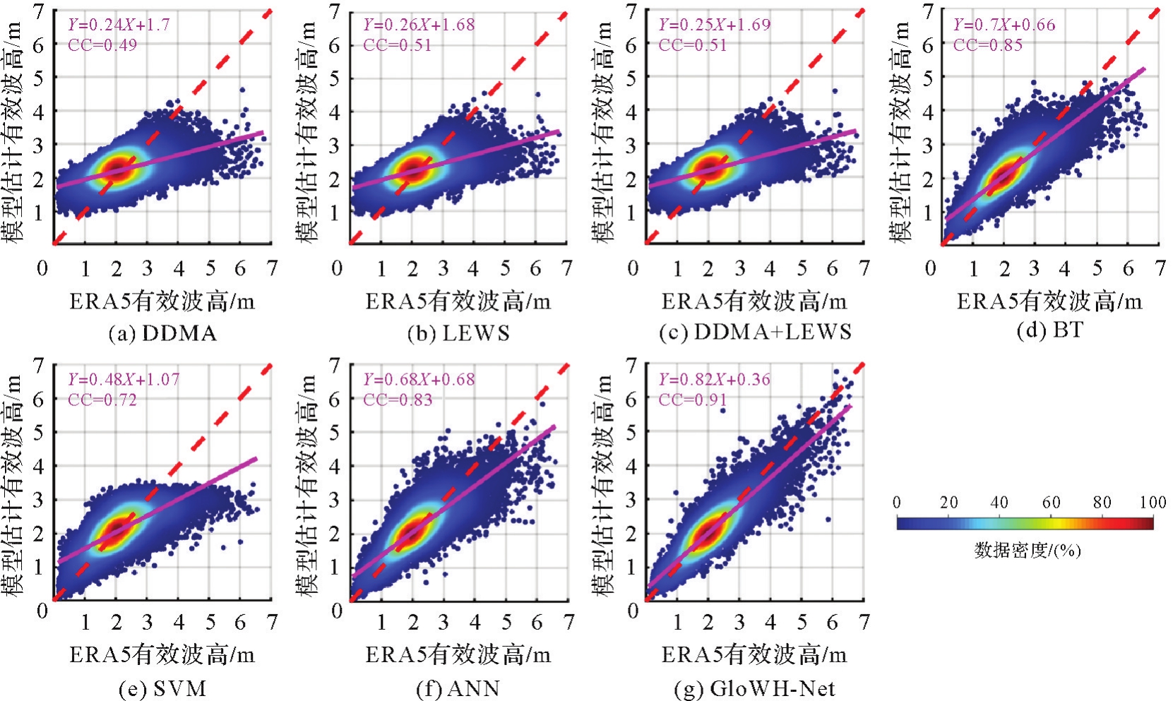
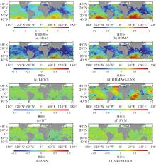
Fig.5
Global distribution of ERA5 significant wave height data and retrieved significant wave height bias by different models"

Deviation distribution between ERA5 significant wave height and retrieved significant wave height by different models"

Accuracy of comparison between the significant wave height retrieved by different models on the test data set and WW3 data"
| 模型 | RMSE/m | Bias/m | CC | MAPE/(%) |
|---|---|---|---|---|
| 经验模型(DDMA方法) | 0.757 | 0.050 | 0.48 | 32.02 |
| 经验模型(LEWS方法) | 0.757 | -0.031 | 0.48 | 33.44 |
| 经验模型(DDMA+LEWS方法) | 0.757 | 0.046 | 0.48 | 32.09 |
| BT | 0.483 | 0.033 | 0.83 | 16.65 |
| SVM | 0.625 | 0.097 | 0.69 | 23.17 |
| ANN | 0.502 | 0.039 | 0.81 | 17.98 |
| GloWH-Net | 0.393 | 0.073 | 0.89 | 14.29 |
Tab.5
Accuracy of comparison between the significant wave height retrieved by different models on the test data set and AVISO data"
| 模型 | RMSE/m | Bias/m | CC | MAPE/(%) |
|---|---|---|---|---|
| 经验模型(DDMA方法) | 0.707 | -0.015 | 0.46 | 30.19 |
| 经验模型(LEWS方法) | 0.801 | -0.371 | 0.47 | 39.25 |
| 经验模型(DDMA+LEWS方法) | 0.730 | -0.193 | 0.47 | 33.93 |
| BT | 0.453 | -0.021 | 0.82 | 16.51 |
| SVM | 0.551 | 0.042 | 0.72 | 21.75 |
| ANN | 0.469 | -0.012 | 0.81 | 17.36 |
| GloWH-Net | 0.433 | 0.019 | 0.84 | 15.16 |
Comparison results of different combinations of spaceborne GNSS-R observation variable parameters inputted into the GloWH-Net model to retrieve SWH and ERA5 data"
Tab.6
Performance statistics of SWH retrieval using different auxiliary variables as input parameters for the GloWH-Net model"
| 辅助变量参数 | RMSE/m | Bias/m | CC | MAPE/m |
|---|---|---|---|---|
| 未考虑 | 0.413 | -0.027 | 0.86 | 15.28 |
| 降雨(RI) | 0.422 | 0.004 | 0.86 | 15.26 |
| 风速(WS) | 0.336 | 0.035 | 0.91 | 12.19 |
| 风向(WD) | 0.345 | -0.034 | 0.91 | 13.15 |
| 水深(wd) | 0.413 | -0.007 | 0.86 | 14.95 |
| RI+WS+WD+wd | 0.257 | -0.024 | 0.95 | 9.88 |
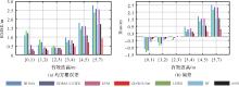
Fig.8
Retrieval performance of different models in different SWH ranges"

| [1] | SOULAT F, CAPARRINI M, GERMAIN O, et al. Sea state monitoring using coastal GNSS-R[J]. Geophysical Research Letters, 2004, 31(21):L21303. |
| [2] | SHAH R, GARRISON J L, EGIDO A, et al. Bistatic radar measurements of significant wave height using signals of opportunity in L-, S-, and Ku-bands [J]. IEEE Transactions on Geoscience and Remote Sensing, 2016, 54(2):826-841. |
| [3] | ALONSO-ARROYO A, CAMPS A, PARK H, et al. Retrieval of significant wave height and mean sea surface level using the GNSS-R interference pattern technique: results from a three-month field campaign [J]. IEEE Transactions on Geoscience and Remote Sensing, 2015, 53(6):3198-3209. |
| [4] | 王鑫, 孙强, 张训械, 等. 中国首次岸基GNSS-R海洋遥感实验[J]. 科学通报, 2008, 53(5):589-592. |
| WANG Xin, SUN Qiang, ZHANG Xunxie, et al. The first shore-based GNSS-R ocean remote sensing experiment in China[J]. Chinese Science Bulletin, 2008, 53(5):589-592. | |
| [5] | 邵连军, 张训械, 王鑫, 等. 利用GNSS-R信号反演海浪波高[J]. 武汉大学学报(信息科学版), 2008, 33(5):475-478. |
| SHAO Lianjun, ZHANG Xunxie, WANG Xin, et al. Sea surface wave height retrieve using GNSS-R signals[J]. Geomatics and Information Science of Wuhan University, 2008, 33(5):475-478. | |
| [6] | 金玲. GNSS-R接收机及有效波高反演方法研究[D]. 北京: 北京化工大学, 2016. |
| JIN Ling. Research on receiver and inversion method of significant wave height based on GNSS-R[D]. Beijing: Beijing University of Chemical Technology, 2016. | |
| [7] | 李颖, 朱雪瑗, 崔璨, 等. 船载GNSS-R有效波高测量的初步研究[J]. 海洋环境科学, 2016, 35(2):180-183. |
| LI Ying, ZHU Xueyuan, CUI Can, et al. Preliminary study on ship-borne significant wave height measurement using GNSS-R signals[J]. Marine Environmental Science, 2016, 35(2):180-183. | |
| [8] | 徐飞, 孙协昌, 刘馨宁, 等. 利用机载GNSS-R的有效波高反演技术[J]. 飞行器测控学报, 2017, 36(3):212-218. |
| XU Fei, SUN Xiechang, LIU Xinning, et al. A method of retrieval of significant wave height using airborne GNSS-R[J]. Journal of Spacecraft TT & C Technology, 2017, 36(3):212-218. | |
| [9] | QIN Lingyu, LI Ying. Significant wave height estimation using multi-satellite observations from GNSS-R[J]. Remote Sensing, 2021, 13(23):4806. |
| [10] | 俞永庆. 岸基GNSS反射信号有效波高反演研究[J]. 无线电工程, 2021, 51(10):1075-1079. |
| YU Yongqing. Retrieval of significant wave height using coastal GNSS reflectometry[J]. Radio Engineering, 2021, 51(10):1075-1079. | |
| [11] | 张一, 周立. 基于NARX回归神经网络的岸基GNSS-IR有效波高反演模型分析[J]. 测绘通报, 2022(2):90-94. |
| ZHANG Yi, ZHOU Li. Study on inversion model of significant wave height from shore-based GNSS-IR by using NARX recurrent neural network[J]. Bulletin of Surveying and Mapping, 2022(2):90-94. | |
| [12] | WANG Xiaolei, HE Xiufeng, SHI Jian, et al. Estimating sea level, wind direction, significant wave height, and wave peak period using a geodetic GNSS receiver[J]. Remote Sensing of Environment, 2022, 279:113135. |
| [13] | ALPERS W, HASSELMANN K. Spectral signal to clutter and thermal noise properties of ocean wave imaging synthetic aperture radars[J]. International Journal of Remote Sensing, 1982, 3(4):423-446. |
| [14] | PENG Qin, JIN Shuanggen. Significant wave height estimation from space-borne cyclone-GNSS reflectometry[J]. Remote Sensing, 2019, 11(5):584. |
| [15] | YANG Shuai, JIN Shuanggen, JIA Yan, et al. Significant wave height estimation from joint CYGNSS DDMA and LES observations[J]. Sensors, 2021, 21(18):6123. |
| [16] | BU Jinwei, YU Kegen. Significant wave height retrieval method based on spaceborne GNSS reflectometry[J]. IEEE Geoscience and Remote Sensing Letters, 2022, 19:1503705. |
| [17] | BU Jinwei, YU Kegen. A new integrated method of CYGNSS DDMA and LES measurements for significant wave height estimation[J]. IEEE Geoscience and Remote Sensing Letters, 2022, 19:1505605. |
| [18] | 布金伟, 余科根, 韩帅. 星载GNSS-R海浪有效波高反演模型构建[J]. 测绘学报, 2022, 51(9):1920-1930. DOI: 10.11947/j.AGCS.2022.20210284. |
| BU Jinwei, YU Kegen, HAN Shuai. Construction of spaceborne GNSS-R ocean waves significant wave height retrieval model[J]. Acta Geodaetica et Cartographica Sinica, 2022, 51(9):1920-1930. DOI: 10.11947/j.AGCS.2022.20210284. | |
| [19] | ASGARIMEHR M, ARNOLD C, WEIGEL T, et al. GNSS reflectometry global ocean wind speed using deep learning: development and assessment of CyGNSSnet[J]. Remote Sensing of Environment, 2022, 269:112801. |
| [20] | WANG Feng, YANG Dongkai, YANG Lei. Retrieval and assessment of significant wave height from CYGNSS mission using neural network[J]. Remote Sensing, 2022, 14(15):3666. |
| [21] | WANG Changyang, YU Kegen, ZHANG Kefei, et al. Significant wave height retrieval based on multivariable regression models developed with CYGNSS data[J]. IEEE Transactions on Geoscience and Remote Sensing, 2023, 61:4200415. |
| [22] | BU Jinwei, YU Kegen, ZHU Feiyang, et al. Joint retrieval of sea surface rainfall intensity, wind speed, and wave height based on spaceborne GNSS-R: a case study of the oceans near China[J]. Remote Sensing, 2023, 15(11):2757. |
| [23] | BU Jinwei, YU Kegen, PARK H, et al. Estimation of swell height using spaceborne GNSS-R data from eight CYGNSS satellites[J]. Remote Sensing, 2022, 14(18):4634. |
| [24] | CLARIZIA M P, RUF C S, JALES P, et al. Spaceborne GNSS-R minimum variance wind speed estimator[J]. IEEE Transactions on Geoscience and Remote Sensing, 2014, 52(11):6829-6843. |
| [25] | REYNOLDS J, CLARIZIA M P, SANTI E. Wind speed estimation from CYGNSS using artificial neural networks[J]. IEEE Journal of Selected Topics in Applied Earth Observations and Remote Sensing, 2020, 13:708-716. |
| [26] | WANG Changyang, YU Kegen, QU Fangyu, et al. Spaceborne GNSS-R wind speed retrieval using machine learning methods[J]. Remote Sensing, 2022, 14(14):3507. |
| [27] | ERTUGRUL Ö F. A novel type of activation function in artificial neural networks: trained activation function[J]. Neural Networks, 2018, 99:148-157. |
| [28] | BU Jinwei, YU Kegen, NI Jun, et al. Combining ERA5 data and CYGNSS observations for the joint retrieval of global significant wave height of ocean swell and wind wave: a deep convolutional neural network approach[J]. Journal of Geodesy, 2023, 97(8):81. |
| [29] | SOISUVARN S, JELENAK Z, SAID F, et al. The GNSS reflectometry response to the ocean surface winds and waves [J]. IEEE Journal of Selected Topics in Applied Earth Observations and Remote Sensing, 2016, 9(10):4678-4699. |
| [1] | BU Jinwei, YU Kegen, HAN Shuai. Construction of spaceborne GNSS-R ocean waves significant wave height retrieval model [J]. Acta Geodaetica et Cartographica Sinica, 2022, 51(9): 1920-1930. |
| [2] | SONG Yue, LI Houpu, ZHAI Guojun. Comparative analysis of airborne laser bathymetric waveforms denoising algorithms [J]. Acta Geodaetica et Cartographica Sinica, 2021, 50(2): 270-278. |
| [3] | . A Semi-empirical Model for the Correction of Terrain Influences in SAR Backscattering [J]. Acta Geodaetica et Cartographica Sinica, 2011, 40(4): 0-441. |
| Viewed | ||||||
|
Full text |
|
|||||
|
Abstract |
|
|||||