

Acta Geodaetica et Cartographica Sinica ›› 2024, Vol. 53 ›› Issue (6): 1057-1076.doi: 10.11947/j.AGCS.2024.20230259
• Smart Surveying and Mapping • Previous Articles Next Articles
Chi GUO1,2,3( ), Yang LIU1, Yarong LUO2, Jingnan LIU2, Quan ZHANG2
Received:2023-09-08
Published:2024-07-22
About author:GUO Chi (1983—), male, PhD, professor, majors in the application of BeiDou technology, intelligent navigation of unmanned systems, and theoretical methods of location services. E-mail: guochi@whu.edu.cn
Supported by:CLC Number:
Chi GUO, Yang LIU, Yarong LUO, Jingnan LIU, Quan ZHANG. Research progress in the application of image semantic information in visual SLAM[J]. Acta Geodaetica et Cartographica Sinica, 2024, 53(6): 1057-1076.
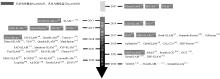
Fig.1
Trends in visual semantic SLAM"
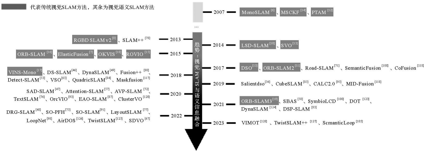
Fig.2
Framework of visual semantic SLAM methods"

Tab.1
Semantic information in images and relevant classical approaches"
| 语义获取方法 | 语义形式 | 实例 | 非实例 | 轮廓 | 经典方法 |
|---|---|---|---|---|---|
| 目标检测 | 物体的矩形检测框、类别及分类置信度 | √ | × | × | Faster-RCNN[ |
| 语义分割 | 每个像素的类别及分类置信度 | × | √ | √ | FCN[ |
| 实例分割 | 物体的像素区域掩码、类别及分类置信度 | √ | × | √ | Mask-RCNN[ |
| 全景分割 | 可数物体与不可数物体的像素区域掩码、类别及分类置信度 | √ | √ | √ | Panoptic Segmentation[ |
| 视觉显著性检测 | 图像中每个像素的显著性评分 | — | — | — | SalGAN[ |
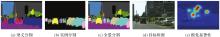
Fig.3
Semantic information obtained by detection, segmentation, and visual saliency methods"
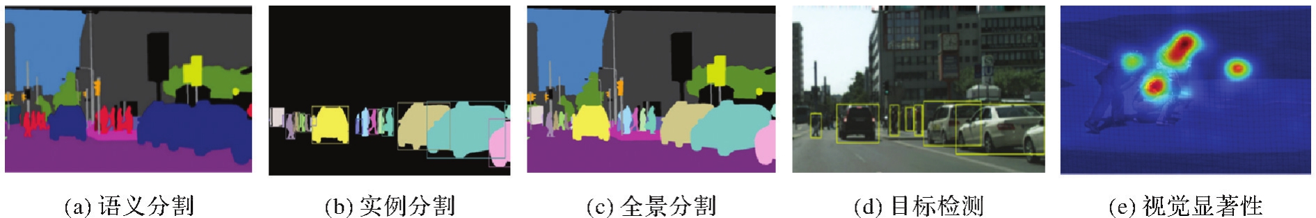
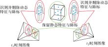
Fig.4
Dynamic feature rejection methods"
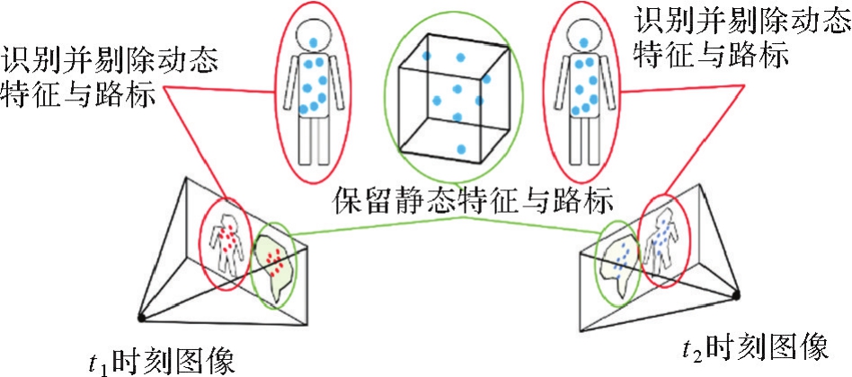

Fig.5
Key information screening and weighting for fusion of semantic information"
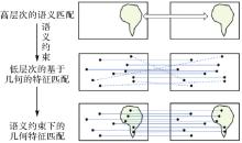
Fig.6
Feature matching constrained by Semantic Information"
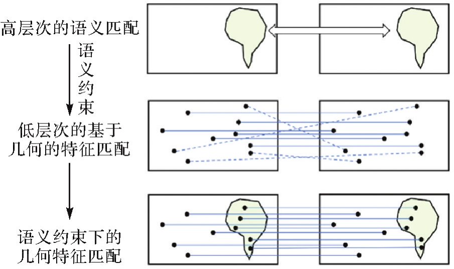
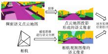
Fig.7
Localization by aligning dense semantic pixels and point cloud"


Fig.8
Localization by key semantic elements matching"
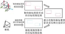
Fig.9
Localization by geometric parameters of object landmarks"
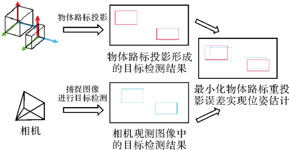
Fig.10
Scene re-recognition based on object topology information"

Fig.11
Object-level data association"
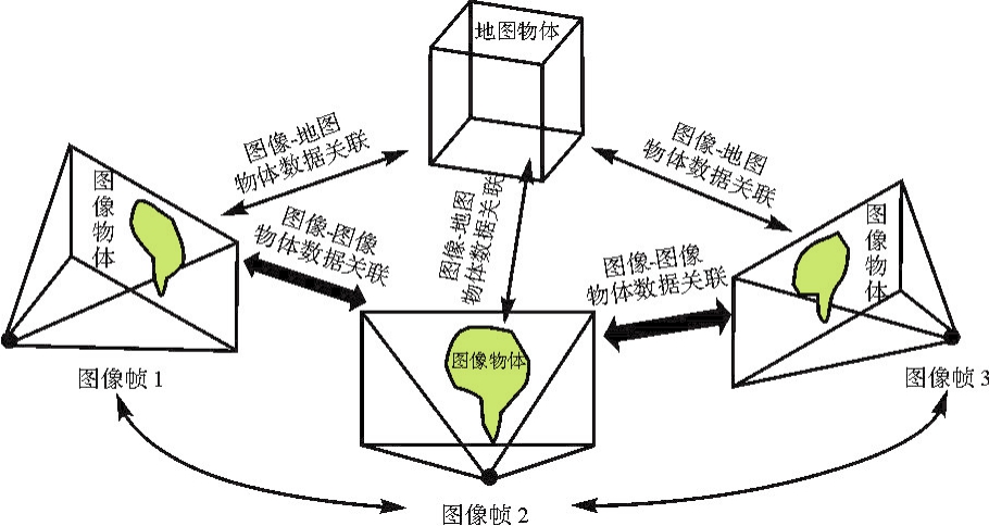

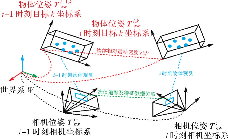
Fig.12
Dynamic object tracking and pose estimation"
| [1] | 刘经南, 罗亚荣, 郭迟, 等. PNT智能与智能PNT[J]. 测绘学报, 2022, 51(6):811-828.DOI:10.11947/j.AGCS.2022.20220152. |
| LIU Jingnan, LUO Yarong, GUO Chi, et al. PNT intelligence and intelligent PNT[J]. Acta Geodaetica et Cartographica Sinica, 2022, 51(6):811-828. DOI:10.11947/j.AGCS.2022.20220152. | |
| [2] | 张继贤, 刘飞. 视觉SLAM环境感知技术现状与智能化测绘应用展望[J]. 测绘学报, 2023, 52(10):1617-1630.DOI:10.11947/j.AGCS.2023.20220240. |
| ZHANG Jixian, LIU Fei. Review of visual SLAM environment perception technology and intelligent surveying and mapping application[J]. Acta Geodaetica et Cartographica Sinica, 2023, 52(10):1617-1630. DOI:10.11947/j.AGCS.2023.20220240. | |
| [3] | CADENA C, CARLONE L, CARRILLO H, et al. Past, present, and future of simultaneous localization and mapping: toward the robust-perception age[J]. IEEE Transactions on Robotics, 2016, 32(6):1309-1332. |
| [4] | 陈军, 艾廷华, 闫利, 等. 智能化测绘的混合计算范式与方法研究[J/OL]. 测绘学报: 1-19 [2024-05-18]. http://kns.cnki.net/kcms/detail/11.2089.P.20240415.1049.002.html. |
| CHEN Jun, AI Tinghua, YAN Li, et al. Hybrid computational paradigm and methods for intelligentized surveying and mapping[J/OL]. Acta Geodaetica et Cartographica Sinica: 1-19 [2024-05-18]. http://kns.cnki.net/kcms/detail/11.2089.P.20240415.1049.002.html. | |
| [5] | 邸凯昌, 万文辉, 赵红颖, 等. 视觉SLAM技术的进展与应用[J]. 测绘学报, 2018, 47(6):770-779.DOI:10.11947/j.AGCS.2018.20170652. |
| DI Kaichang, WAN Wenhui, ZHAO Hongying, et al. Progress and applications of visual SLAM[J]. Acta Geodaetica et Cartographica Sinica, 2018, 47(6):770-779. DOI:10.11947/j.AGCS.2018.20170652. | |
| [6] | DAVISON A J, REID I D, MOLTON N D, et al. MonoSLAM: real-time single camera SLAM[J]. IEEE Transactions on Pattern Analysis and Machine Intelligence, 2007, 29(6):1052-1067. |
| [7] | WHELAN T, LEUTENEGGER S, SALAS MORENO R, et al. ElasticFusion: dense SLAM without A pose graph[C]//Proceedings of 2015 Robotics: Science and Systems XI. Robotics: Science and Systems Foundation, 2015. |
| [8] | ENDRES F, HESS J, STURM J, et al. 3-D mapping with an RGB-D camera[J]. IEEE Transactions on Robotics, 2014, 30(1):177-187. |
| [9] | MUR-ARTAL R, TARDÓS J D. ORB-SLAM2: an open-source SLAM system for monocular, stereo, and RGB-D cameras[J]. IEEE Transactions on Robotics, 2017, 33(5):1255-1262. |
| [10] | ENGEL J, SCHÖPS T, CREMERS D. LSD-SLAM: large-scale direct monocular SLAM[M]//FLEET D, PAJDLA T, SCHIELE B, et al, eds. Computer Vision-ECCV 2014. Cham: Springer International Publishing, 2014: 834-849. |
| [11] | ENGEL J, KOLTUN V, CREMERS D. Direct sparse odometry[J]. IEEE Transactions on Pattern Analysis and Machine Intelligence, 2018, 40(3):611-625. |
| [12] | KLEIN G, MURRAY D. Parallel tracking and mapping for small AR workspaces[C]//Proceedings of 2007 IEEE and ACM International Symposium on Mixed and Augmented Reality. Nara: IEEE, 2007: 225-234. |
| [13] | FORSTER C, PIZZOLI M, SCARAMUZZA D. SVO: fast semi-direct monocular visual odometry[C]//Proceedings of 2014 IEEE International Conference on Robotics and Automation. Hong Kong: IEEE, 2014: 15-22. |
| [14] | MOURIKIS A I, ROUMELIOTIS S I. A multi-state constraint Kalman filter for vision-aided inertial navigation[C]//Proceedings of 2007 IEEE International Conference on Robotics and Automation. Rome: IEEE, 2007: 3565-3572. |
| [15] | BLOESCH M, OMARI S, HUTTER M, et al. Robust visual inertial odometry using a direct EKF-based approach[C]//Proceedings of 2015 IEEE/RSJ International Conference on Intelligent Robots and Systems (IROS). Hamburg: IEEE, 2015: 298-304. |
| [16] | MUR-ARTAL R, MONTIEL J M M, TARDÓS J D. ORB-SLAM: a versatile and accurate monocular SLAM system[J]. IEEE Transactions on Robotics, 2015, 31(5):1147-1163. |
| [17] | QIN Tong, LI Peiliang, SHEN Shaojie. VINS-mono: a robust and versatile monocular visual-inertial state estimator[J]. IEEE Transactions on Robotics, 2018, 34(4):1004-1020. |
| [18] | LEUTENEGGER S, LYNEN S, BOSSE M, et al. Keyframe-based visual-inertial odometry using nonlinear optimization[J]. The International Journal of Robotics Research, 2015, 34(3):314-334. |
| [19] | CAMPOS C, ELVIRA R, RODRÍGUEZ J J G, et al. ORB-SLAM3: an accurate open-source library for visual, visual-inertial, and multimap SLAM[J]. IEEE Transactions on Robotics, 2021, 37(6):1874-1890. |
| [20] | DETONE D, MALISIEWICZ T, RABINOVICH A. SuperPoint: self-supervised interest point detection and description[C]//Proceedings of 2018 IEEE/CVF Conference on Computer Vision and Pattern Recognition Workshops. Salt Lake City: IEEE, 2018: 337-33712. |
| [21] | LINDENBERGER P, SARLIN P E, POLLEFEYS M. LightGlue: local feature matching at lightspeed[C]//Proceedings of 2023 IEEE/CVF International Conference on Computer Vision. Paris: IEEE, 2023: 17627-17638. |
| [22] | SUN Jiaming, SHEN Zehong, WANG Yuang, et al. LoFTR: detector-free local feature matching with transformers[C]//Proceedings of 2021 IEEE/CVF Conference on Computer Vision and Pattern Recognition. Nashville: IEEE, 2021: 8918-8927. |
| [23] | REN Shaoqing, HE Kaiming, GIRSHICK R, et al. Faster R-CNN: towards real-time object detection with region proposal networks[J]. IEEE Transactions on Pattern Analysis and Machine Intelligence, 2017, 39(6):1137-1149. |
| [24] | LIU Wei, ANGUELOV D, ERHAN D, et al. SSD: single shot MultiBox detector[M]//LEIBE B, MATAS J, SEBE N, et al, eds. Computer Vision-ECCV 2016. Cham: Springer International Publishing, 2016: 21-37. |
| [25] | REDMON J, DIVVALA S, GIRSHICK R, et al. You only look once: unified, real-time object detection[C]//Proceedings of 2016 IEEE Conference on Computer Vision and Pattern Recognition. Las Vegas: IEEE, 2016: 779-788. |
| [26] | REDMON J, FARHADI A. YOLO9000: better, faster, stronger[C]//Proceedings of 2017 IEEE Conference on Computer Vision and Pattern Recognition. Honolulu: IEEE, 2017: 6517-6525. |
| [27] | WANG C Y, BOCHKOVSKIY A, LIAO H Y M. YOLOv7: Trainable bag-of-freebies sets new state-of-the-art for real-time object detectors[C]//Proceedings of 2023 IEEE/CVF Conference on Computer Vision and Pattern Recognition. Vancouver: IEEE, 2023: 7464-7475. |
| [28] | JOCHER G. YOLOv8[EB/OL]. 2024-06-10[2024-06-13]. https://github.com/ultralytics/ultralytics. |
| [29] | SHELHAMER E, LONG J, DARRELL T. Fully convolutional networks for semantic segmentation[C]//Proceedings of 2017 IEEE Transactions on Pattern Analysis and Machine Intelligence. IEEE, 2017: 640-651. |
| [30] | BADRINARAYANAN V, KENDALL A, CIPOLLA R. SegNet: a deep convolutional encoder-decoder architecture for image segmentation[J]. IEEE Transactions on Pattern Analysis and Machine Intelligence, 2017, 39(12):2481-2495. |
| [31] | CHEN L C, PAPANDREOU G, KOKKINOS I, et al. DeepLab: semantic image segmentation with deep convolutional nets, atrous convolution, and fully connected CRFs[J]. IEEE Transactions on Pattern Analysis and Machine Intelligence, 2018, 40(4):834-848. |
| [32] | CHEN L C, ZHU Yukun, PAPANDREOU G, et al. Encoder-decoder with atrous separable convolution for semantic image segmentation[C]//Proceedings of 2018 Computer Vision European Conference. Munich: ACM Press, , 2018: 833-851. |
| [33] | YU Changqian, WANG Jingbo, PENG Chao, et al. BiSeNet: bilateral segmentation network for real-time semantic segmentation[C]//Proceedings of 2018 European Conference on Computer Vision. Cham: Springer, 2018: 334-349. |
| [34] | YU C, GAO C, WANG J, et al. Bisenet v2: bilateral network with guided aggregation for real-time semantic segmentation[J]. International Journal of Computer Vision, 2021, 129:3051-3068. |
| [35] | HE K, GKIOXARI G, DOLLÁR P, et al. Mask R-CNN[C]//Proceedings of 2017 IEEE International Conference on Computer Vision. Venice: IEEE, 2017: 2961-2969. |
| [36] | BOLYA D, ZHOU C, XIAO F, et al. Yolact: Real-time instance segmentation[C]//Proceedings of 2019 IEEE/CVF International Conference on Computer Vision. Seoul: IEEE, 2019: 9157-9166. |
| [37] | KIRILLOV A, HE K, GIRSHICK R, et al. Panoptic segmentation[C]//Proceedings of 2019 IEEE/CVF Conference on Computer Vision and Pattern Recognition. Long Beach: IEEE, 2019: 9404-9413. |
| [38] | XIONG Y, LIAO R, ZHAO H, et al. Upsnet: A unified panoptic segmentation network[C]//Proceedings of 2019 IEEE/CVF Conference on Computer Vision and Pattern Recognition. Long Beach: IEEE, 2019: 8818-8826. |
| [39] | CHANG C Y, CHANG S E, HSIAO P Y, et al. EPSNet: efficient panoptic segmentation network with cross-layer attention fusion[C]//Proceedings of 2020 Asian Conference on Computer Vision. Kyoto: Springer, 2020. |
| [40] | ZHAN Jiao, LUO Yarong, GUO Chi, et al. YOLOPX: anchor-free multi-task learning network for panoptic driving perception[J]. Pattern Recognition, 2024, 148:110152. |
| [41] | PAN Junting, FERRER C C, MCGUINNESS K, et al. SalGAN: visual saliency prediction with generative adversarial networks[EB/OL]. 2019-01-01[2024-06-13]. https://github.com/imatge-upc/salgan. |
| [42] | YANG Sheng, LIN Guosheng, JIANG Qiuping, et al. A dilated inception network for visual saliency prediction[J]. IEEE Transactions on Multimedia, 2020, 22(8):2163-2176. |
| [43] | LIN T Y, MAIRE M, BELONGIE S, et al. Microsoft COCO: common objects in context[M]//Computer Vision-ECCV 2014. Cham: Springer International Publishing, 2014: 740-755. |
| [44] | CORDTS M, OMRAN M, RAMOS S, et al. The cityscapes dataset for semantic urban scene understanding[C]//Proceedings of 2016 IEEE Conference on Computer Vision and Pattern Recognition. Las Vegas: IEEE, 2016: 3213-3223. |
| [45] | GEIGER A, LENZ P, URTASUN R. Are we ready for autonomous driving? The KITTI vision benchmark suite[C]//Proceedings of 2012 IEEE Conference on Computer Vision and Pattern Recognition. Providence: IEEE, 2012: 3354-3361. |
| [46] | YU Chao, LIU Zuxin, LIU Xinjun, et al. DS-SLAM: a semantic visual SLAM towards dynamic environments[C]//Proceedings of 2018 IEEE/RSJ International Conference on Intelligent Robots and Systems. Madrid: IEEE, 2018: 1168-1174. |
| [47] | YUAN Xun, CHEN Song. SaD-SLAM: a visual SLAM based on semantic and depth information[C]//Proceedings of 2020 IEEE/RSJ International Conference on Intelligent Robots and Systems. Las Vegas: IEEE, 2020: 4930-4935. |
| [48] | WANG Yanan, XU Kun, TIAN Yaobin, et al. DRG-SLAM: a Semantic RGB-D SLAM using Geometric Features for Indoor Dynamic Scene[C]//2022 IEEE/RSJ International Conference on Intelligent Robots and Systems (IROS). Kyoto: IEEE, 2022: 1352-1359. |
| [49] | BESCOS B, FÁCIL J M, CIVERA J, et al. DynaSLAM: tracking, mapping, and inpainting in dynamic scenes[J]. IEEE Robotics and Automation Letters, 2018, 3(4):4076-4083. |
| [50] | JI Tete, WANG Chen, XIE Lihua. Towards real-time semantic RGB-D SLAM in dynamic environments[C]//Proceedings of 2021 IEEE International Conference on Robotics and Automation. Xian: IEEE, 2021: 11175-11181. |
| [51] | WANG Kai, LIN Yimin, WANG Luowei, et al. A unified framework for mutual improvement of SLAM and semantic segmentation[C]//Proceedings of 2019 International Conference on Robotics and Automation. Montreal: IEEE, 2019: 5224-5230. |
| [52] | BRASCH N, BOZIC A, LALLEMAND J, et al. Semantic monocular SLAM for highly dynamic environments[C]//Proceedings of 2018 IEEE/RSJ International Conference on Intelligent Robots and Systems. Madrid: IEEE, 2018: 393-400. |
| [53] | ZHONG Fangwei, WANG Sheng, ZHANG Ziqi, et al. Detect-SLAM: making object detection and SLAM mutually beneficial[C]//Proceedings of 2018 IEEE Winter Conference on Applications of Computer Vision. Lake Tahoe: IEEE, 2018: 1001-1010. |
| [54] | GANTI P, WASLANDER S L. Network uncertainty informed semantic feature selection for visual SLAM[C]//Proceedings of 2019 Conference on Computer and Robot Vision. Kingston: IEEE, 2019: 121-128. |
| [55] | ALONSO I, RIAZUELO L, MURILLO A C. Enhancing V-SLAM keyframe selection with an efficient ConvNet for semantic analysis[C]//Proceedings of 2019 International Conference on Robotics and Automation. Montreal: IEEE, 2019: 4717-4723. |
| [56] | LIANG H J, SANKET N J, FERMÜLLER C, et al. SalientDSO: bringing attention to direct sparse odometry[J]. IEEE Transactions on Automation Science and Engineering, 2019, 16(4):1619-1626. |
| [57] | LI Jinquan, PEI Ling, ZOU Danping, et al. Attention-SLAM: a visual monocular SLAM learning from human gaze[J]. IEEE Sensors Journal, 2021, 21(5):6408-6420. |
| [58] | WANG Ke, MA Sai, REN Fan, et al. SBAS: salient bundle adjustment for visual SLAM[J]. IEEE Transactions on Instrumentation and Measurement, 2021, 70:5014709. |
| [59] | YE Chenxi, WANG Yiduo, LU Ziwen, et al. Exploiting semantic and public prior information in MonoSLAM[C]//Proceedings of 2020 IEEE/RSJ International Conference on Intelligent Robots and Systems. Las Vegas: IEEE, 2020: 4936-4941. |
| [60] | SHI Tianxin, SHEN Shuhan, GAO Xiang, et al. Visual localization using sparse semantic 3D map[C]//Proceedings of 2019 IEEE International Conference on Image Processing. Taipei: IEEE, 2019: 315-319. |
| [61] | XUE Fei, BUDVYTIS I, CIPOLLA R. SFD2: semantic-guided feature detection and description[C]//Proceedings of 2023 IEEE/CVF Conference on Computer Vision and Pattern Recognition. Vancouver: IEEE, 2023: 5206-5216. |
| [62] | ZHANG Yesheng, ZHAO Xu. MESA: matching everything by segmenting anything [C]//Proceedings of 2024 IEEE/CVF Conference on Computer Vision and Pattern Recognition. Seattle: IEEE, 2024. |
| [63] | KIRILLOV A, MINTUN E, RAVI N, et al. Segment anything[C]//Proceedings of the IEEE/CVF International Conference on Computer Vision. Paris: IEEE, 2023: 4015-4026. |
| [64] | STENBORG E, TOFT C, HAMMARSTRAND L. Long-term visual localization using semantically segmented images[C]//Proceedings of 2018 IEEE International Conference on Robotics and Automation. Brisbane: IEEE, 2018: 6484-6490. |
| [65] | LIANOS K N, SCHÖNBERGER J L, POLLEFEYS M, et al. VSO: visual semantic odometry[C]//Proceedings of 2018 Computer Vision. Munich: ACM Press, 2018: 246-263. |
| [66] | HERB M, LEMBERGER M, SCHMITT M M, et al. Semantic image alignment for vehicle localization[C]//Proceedings of 2021 IEEE/RSJ International Conference on Intelligent Robots and Systems. Prague, Czech Republic. IEEE, 2021: 1124-1131. |
| [67] | BAO Yaoqi, YANG Zhe, PAN Yun, et al. Semantic-direct visual odometry[J]. IEEE Robotics and Automation Letters, 2022, 7(3):6718-6725. |
| [68] | 刘经南, 詹骄, 郭迟, 等. 智能高精地图数据逻辑结构与关键技术[J]. 测绘学报, 2019, 48(8):939-953.DOI:CNKI:SUN:CHXB.0.2019-08-002. |
| LIU Jingnan, ZHAN Jiao, GUO Chi, et al. Data logic structure and key technologies on intelligent high-precision map[J]. Acta Geodaetica et Cartographica Sinica, 2019, 48(8):939-953.DOI:CNKI:SUN:CHXB.0.2019-08-002. | |
| [69] | JEONG J, CHO Y, KIM A. Road-SLAM: Road marking based SLAM with lane-level accuracy[C]//Proceedings of 2017 IEEE Intelligent Vehicles Symposium. Los Angeles: IEEE, 2017: 1736-1473. |
| [70] | QIN Tong, ZHENG Yuxin, CHEN Tongqing, et al. A light-weight semantic map for visual localization towards autonomous driving[C]//Proceedings of 2021 IEEE International Conference on Robotics and Automation. Xi'an: IEEE, 2021: 11248-11254. |
| [71] | QIAO Zhijian, YU Zehuan, YIN Huan, et al. Online monocular lane mapping using catmull-rom spline[C]//Proceedings of 2023 IEEE/RSJ International Conference on Intelligent Robots and Systems. Detroit: IEEE, 2023: 7179-7186. |
| [72] | QIN Tong, CHEN Tongqing, CHEN Yilun, et al. AVP-SLAM: semantic visual mapping and localization for autonomous vehicles in the parking lot[C]//Proceedings of 2020 IEEE/RSJ International Conference on Intelligent Robots and Systems (IROS). Las Vegas: IEEE, 2020: 5939-5945. |
| [73] | XIANG Zhenzhen, BAO Anbo, SU Jianbo. Hybrid bird's-eye edge based semantic visual SLAM for automated valet parking[C]//Proceedings of 2021 IEEE International Conference on Robotics and Automation. Xi'an: IEEE, 2021: 11546-11552. |
| [74] | CHENG Wentao, YANG Sheng, ZHOU Maomin, et al. Road mapping and localization using sparse semantic visual features[J]. IEEE Robotics and Automation Letters, 2021, 6(4):8118-8125. |
| [75] | LV Jixin, MENG Chao, WANG Yue, et al. SO-PFH: semantic object-based point feature histogram for global localization in parking lot[C]//Proceedings of 2022 IEEE/RSJ International Conference on Intelligent Robots and Systems. Kyoto: IEEE, 2022: 4431-4438. |
| [76] | LI Boying, ZOU Danping, SARTORI D, et al. TextSLAM: visual SLAM with planar text features[C]//Proceedings of 2020 IEEE International Conference on Robotics and Automation. Paris: IEEE, 2020: 2102-2108. |
| [77] | GUNJI K, OHNO K, KOJIMA S, et al. LayoutSLAM: object Layout based Simultaneous Localization and Mapping for Reducing Object Map Distortion[C]//Proceedings of 2022 IEEE/RSJ International Conference on Intelligent Robots and Systems. Kyoto: IEEE, 2022: 2825-2832. |
| [78] | SALAS-MORENO R F, NEWCOMBE R A, STRASDAT H, et al. SLAM++: simultaneous localisation and mapping at the level of objects[C]//Proceedings of 2013 IEEE Conference on Computer Vision and Pattern Recognition. Portland: IEEE, 2013: 1352-1359. |
| [79] | PARKHIYA P, KHAWAD R, MURTHY J K, et al. Constructing category-specific models for monocular object-SLAM[C]//Proceedings of 2018 IEEE International Conference on Robotics and Automation. Brisbane: IEEE, 2018: 4517-4524. |
| [80] | MCCORMAC J, CLARK R, BLOESCH M, et al. Fusion++: volumetric object-level SLAM[C]//Proceedings of 2018 International Conference on 3D Vision. Verona: IEEE, 2018: 32-41. |
| [81] | FENG Qiaojun, MENG Yue, SHAN Mo, et al. Localization and Mapping using Instance-specific Mesh Models[C]//Proceedings of 2019 IEEE/RSJ International Conference on Intelligent Robots and Systems. Macau: IEEE, 2019: 4985-4991. |
| [82] | SHARMA A, DONG Wei, KAESS M. Compositional and scalable object SLAM[C]//Proceedings of 2021 IEEE International Conference on Robotics and Automation. Xi'an: IEEE, 2021: 11626-11632. |
| [83] | WANG Jingwen, RÜNZ M, AGAPITO L. DSP-SLAM: object oriented SLAM with deep shape priors[C]//Proceedings of 2021 International Conference on 3D Vision. London: IEEE, 2021: 1362-1371. |
| [84] | NICHOLSON L, MILFORD M, SÜNDERHAUF N. QuadricSLAM: dual quadrics from object detections as landmarks in object-oriented SLAM[J]. IEEE Robotics and Automation Letters, 2019, 4(1):1-8. |
| [85] | YANG Shichao, SCHERER S. CubeSLAM: monocular 3D object SLAM[J]. IEEE Transactions on Robotics, 2019, 35(4):925-938. |
| [86] | OK K, LIU K, FREY K, et al. Robust object-based SLAM for high-speed autonomous navigation[C]//Proceedings of 2019 International Conference on Robotics and Automation. Montreal: IEEE, 2019: 669-675. |
| [87] | WU Yanmin, ZHANG Yunzhou, ZHU Delong, et al. EAO-SLAM: monocular semi-dense object SLAM based on ensemble data association[C]//Proceedings of 2020 IEEE/RSJ International Conference on Intelligent Robots and Systems. Las Vegas: IEEE, 2020: 4966-4973. |
| [88] | QIAN Zhentian, PATATH K, FU Jie, et al. Semantic SLAM with autonomous object-level data association[C]//Proceedings of 2021 IEEE International Conference on Robotics and Automation. Xi'an: IEEE, 2021: 11203-11209. |
| [89] | TIAN Rui, ZHANG Yunzhou, FENG Yonghui, et al. Accurate and robust object SLAM with 3D quadric landmark reconstruction in outdoors[J]. IEEE Robotics and Automation Letters, 2022, 7(2):1534-1541. |
| [90] | SONG Shuangfu, ZHAO Junqiao, FENG Tiantian, et al. Scale estimation with dual quadrics for monocular object SLAM[C]//Proceedings of 2022 IEEE/RSJ International Conference on Intelligent Robots and Systems. Kyoto: IEEE, 2022: 1374-1381. |
| [91] | LIAO Ziwei, HU Yutong, ZHANG Jiadong, et al. SO-SLAM: semantic object SLAM with scale proportional and symmetrical texture constraints[J]. IEEE Robotics and Automation Letters, 2022, 7(2):4008-4015. |
| [92] | XU Binbin, DAVISON A J, LEUTENEGGER S. Learning to complete object shapes for object-level mapping in dynamic scenes[C]//Proceedings of 2022 IEEE/RSJ International Conference on Intelligent Robots and Systems. Kyoto: IEEE, 2022: 2257-2264. |
| [93] | SHAN Mo, FENG Qiaojun, ATANASOV N. OrcVIO: object residual constrained visual-inertial odometry[C]//Proceedings of 2020 IEEE/RSJ International Conference on Intelligent Robots and Systems. Las Vegas: IEEE, 2020: 5104-5111. |
| [94] | GALVEZ-LÓPEZ D, TARDOS J D. Bags of binary words for fast place recognition in image sequences[J]. IEEE Transactions on Robotics, 2012, 28(5):1188-1197. |
| [95] | MERRILL N, HUANG Guoquan. CALC2.0: combining appearance, semantic and geometric information for robust and efficient visual loop closure[C]//Proceedings of 2019 IEEE/RSJ International Conference on Intelligent Robots and Systems. Macau: IEEE, 2019: 4554-4561. |
| [96] | LI J, KOREITEM K, MEGER D, et al. View-invariant loop closure with oriented semantic landmarks[C]//Proceedings of 2020 IEEE International Conference on Robotics and Automation. Paris: IEEE, 2020: 7943-7949. |
| [97] | PAPADIMITRIOU A, KLEITSIOTIS I, KOSTAVELIS I, et al. Loop closure detection and SLAM in vineyards with deep semantic cues[C]//Proceedings of 2022 International Conference on Robotics and Automation. Philadelphia: IEEE, 2022: 2251-2258. |
| [98] | OSMAN H, DARWISH N, BAYOUMI A. LoopNet: where to focus? detecting loop closures in dynamic scenes[J]. IEEE Robotics and Automation Letters, 2022, 7(2):2031-2038. |
| [99] | LIN Shiqi, WANG Jikai, XU Meng, et al. Topology aware object-level semantic mapping towards more robust loop closure[J]. IEEE Robotics and Automation Letters, 2021, 6(4):7041-7048. |
| [100] | KIM J J Y, URSCHLER M, RIDDLE P J, et al. SymbioLCD: ensemble-based loop closure detection using CNN-extracted objects and visual bag-of-words[C]//Proceedings of 2021 IEEE/RSJ International Conference on Intelligent Robots and Systems. Prague: IEEE, 2021: 5425. |
| [101] | KIM J J Y, URSCHLER M, RIDDLE P J, et al. Closing the loop: graph networks to unify semantic objects and visual features for multi-object scenes[C]//Proceedings of 2022 IEEE/RSJ International Conference on Intelligent Robots and Systems. Kyoto: IEEE, 2022: 4352-4358. |
| [102] | QIAN Zhentian, FU Jie, XIAO Jing. Towards accurate loop closure detection in semantic SLAM with 3D semantic covisibility graphs[J]. IEEE Robotics and Automation Letters, 2022, 7(2):2455-2462. |
| [103] | DENG Zhiqiang, ZHANG Yunzhou, WU Yanmin, et al. Object-plane co-represented and graph propagation-based semantic descriptor for relocalization[J]. IEEE Robotics and Automation Letters, 2022, 7(4):11023-11030. |
| [104] | YU Junfeng, SHEN Shaojie. SemanticLoop: loop closure with 3D semantic graph matching[J]. IEEE Robotics and Automation Letters, 2023, 8(2):568-575. |
| [105] | MCCORMAC J, HANDA A, DAVISON A, et al. SemanticFusion: dense 3D semantic mapping with convolutional neural networks[C]//Proceedings of 2017 IEEE International Conference on Robotics and Automation. Singapore: IEEE, 2017: 4628-4635. |
| [106] | GRINVALD M, FURRER F, NOVKOVIC T, et al. Volumetric instance-aware semantic mapping and 3D object discovery[J]. IEEE Robotics and Automation Letters, 2019, 4(3):3037-3044. |
| [107] | OLEYNIKOVA H, TAYLOR Z, FEHR M, et al. Voxblox: incremental 3D Euclidean signed distance fields for on-board MAV planning[C]//Proceedings of 2017 IEEE/RSJ International Conference on Intelligent Robots and Systems. Vancouver: IEEE, 2017: 1366-1373. |
| [108] | POSADA L F, VELASQUEZ-LOPEZ A, HOFFMANN F, et al. Semantic mapping with omnidirectional vision[C]//Proceedings of 2018 IEEE International Conference on Robotics and Automation. Brisbane: IEEE, 2018: 1901-1907. |
| [109] | NAKAJIMA Y, TATENO K, TOMBARI F, et al. Fast and accurate semantic mapping through geometric-based incremental segmentation[C]//Proceedings of 2018 IEEE/RSJ International Conference on Intelligent Robots and Systems. Madrid: IEEE, 2018: 385-392. |
| [110] | HERB M, WEIHERER T, NAVAB N, et al. Crowd-sourced semantic edge mapping for autonomous vehicles[C]//Proceedings of 2019 IEEE/RSJ International Conference on Intelligent Robots and Systems. Macau: IEEE, 2019: 7047-7053. |
| [111] | BOWMAN S L, ATANASOV N, DANIILIDIS K, et al. Probabilistic data association for semantic SLAM[C]//Proceedings of 2017 IEEE International Conference on Robotics and Automation. Singapore. IEEE, 2017: 1722-1729. |
| [112] | ZHANG Jianhua, GUI Mengping, WANG Qichao, et al. Hierarchical topic model based object association for semantic SLAM[J]. IEEE Transactions on Visualization and Computer Graphics, 2019, 25(11):3052-3062. |
| [113] | DOHERTY K J, BAXTER D P, SCHNEEWEISS E, et al. Probabilistic data association via mixture models for robust semantic SLAM[C]//Proceedings of 2020 IEEE International Conference on Robotics and Automation. Paris: IEEE, 2020: 1098-1104. |
| [114] | IQBAL A, GANS N R. Localization of classified objects in SLAM using nonparametric statistics and clustering[C]//Proceedings of 2018 IEEE/RSJ International Conference on Intelligent Robots and Systems. Madrid: IEEE, 2018: 161-168. |
| [115] | LIU Yang, GUO Chi, WANG Yingli. Object-aware data association for the semantically constrained visual SLAM[J]. Intelligent Service Robotics, 2023, 16(2):155-176. |
| [116] | RÜNZ M, AGAPITO L. Co-fusion: real-time segmentation, tracking and fusion of multiple objects[C]//Proceedings of 2017 IEEE International Conference on Robotics and Automation. Singapore. IEEE, 2017: 4471-4478. |
| [117] | RUNZ M, BUFFIER M, AGAPITO L. MaskFusion: real-time recognition, tracking and reconstruction of multiple moving objects[C]//Proceedings of 2018 IEEE International Symposium on Mixed and Augmented Reality. Munich: IEEE, 2018: 10-20. |
| [118] | XU Binbin, LI Wenbin, TZOUMANIKAS D, et al. MID-fusion: octree-based object-level multi-instance dynamic SLAM[C]//Proceedings of 2019 International Conference on Robotics and Automation. Montreal: IEEE, 2019: 5231-5237. |
| [119] | LI Peiliang, QIN Tong, SHEN Shaojie. Stereo vision-based semantic 3D object and ego-motion tracking for autonomous driving[M]//Computer Vision-ECCV 2018. Cham: Springer International Publishing, 2018: 664-679. |
| [120] | HUANG Jiahui, YANG Sheng, MU Taijiang, et al. ClusterVO: clustering moving instances and estimating visual odometry for self and surroundings[C]//Proceedings of 2020 IEEE/CVF Conference on Computer Vision and Pattern Recognition. Seattle: IEEE, 2020: 2165-2174. |
| [121] | HENEIN M, ZHANG Jun, MAHONY R, et al. Dynamic SLAM: the need for speed[C]//Proceedings of 2020 IEEE International Conference on Robotics and Automation. Paris: IEEE, 2020: 2123-2129. |
| [122] | ZHANG Jun, HENEIN M, MAHONY R, et al. VDO-SLAM: a visual dynamic object-aware SLAM system[EB/OL]. 2022-01-09[2024-06-13]. https://github.com/halajun/VDO_SLAM. |
| [123] | BALLESTER I, FONTÁN A, CIVERA J, et al. DOT: dynamic object tracking for visual SLAM[C]//Proceedings of 2021 IEEE International Conference on Robotics and Automation. Xian: IEEE, 2021: 11705-11711. |
| [124] | BESCOS B, CAMPOS C, TARDÓS J D, et al. DynaSLAM II: tightly-coupled multi-object tracking and SLAM[J]. IEEE Robotics and Automation Letters, 2021, 6(3):5191-5198. |
| [125] | GONZALEZ M, MARCHAND E, KACETE A, et al. Twistslam: constrained SLAM in dynamic environment[J]. IEEE Robotics and Automation Letters, 2022, 7(3):6846-6853. |
| [126] | QIU Yuheng, WANG Chen, WANG Wenshan, et al. AirDOS: dynamic SLAM benefits from Articulated Objects[C]//Proceedings of 2022 International Conference on Robotics and Automation. Philadelphia: IEEE, 2022: 8047-8053. |
| [127] | GONZALEZ M, MARCHAND E, KACETE A, et al. TwistSLAM++: Fusing multiple modalities for accurate dynamic semantic SLAM[C]//Proceedings of 2023 IEEE/RSJ International Conference on Intelligent Robots and Systems (IROS). Detroit: IEEE, 2023: 9126-9132. |
| [128] | FENG Shaoquan, LI Xingxing, XIA Chunxi, et al. VIMOT: a tightly coupled estimator for stereo visual-inertial navigation and multiobject tracking[J]. IEEE Transactions on Instrumentation and Measurement, 1011, 72:8504614. |
| [129] | YANG Linghao, ZHANG Yunzhou, TIAN Rui, et al. Fast, robust, accurate, multi-body motion aware SLAM[J]. IEEE Transactions on Intelligent Transportation Systems, 2024, 25(5):4381-4397. |
| [130] | LIU Yang, GUO Chi, LUO Yarong, et al. DynaMeshSLAM: a mesh-based dynamic visual SLAMMOT method[J]. IEEE Robotics and Automation Letters, 2024, 9(6):5791-5798. |
| [131] | PLACED J A, STRADER J, CARRILLO H, et al. A survey on active simultaneous localization and mapping: state of the art and new frontiers[J]. IEEE Transactions on Robotics, 2023, 39(3):1686-1705. |
| [1] | Jiayao WANG, Lin CHEN, Shiyuan CHENG, Lijun WANG, Siqi XIONG. Artificial intelligence empowering the digital-intelligent transformation of cartographic science [J]. Acta Geodaetica et Cartographica Sinica, 2026, 55(3): 381-389. |
| [2] | Xiaomin LU, Zhiyi ZHANG, Haowen YAN, Yi HE, Xiaoning SU. A recognition method for building group pattern integrating deep graph infomax and multilayer perceptron [J]. Acta Geodaetica et Cartographica Sinica, 2026, 55(3): 425-438. |
| [3] | Shunping JI, Jin LIU, Jian GAO, Jianya GONG. An intelligent 3D reconstruction framework via deep learning based multi-view image matching [J]. Acta Geodaetica et Cartographica Sinica, 2025, 54(9): 1633-1646. |
| [4] | Jixian ZHANG, Haiyan GU, Huan NI, Haitao LI, Yi YANG, Shaopeng DING, Songman SUI. Deep learning methods for remote sensing intelligent change detection: evolution and development [J]. Acta Geodaetica et Cartographica Sinica, 2025, 54(8): 1347-1370. |
| [5] | Shuai FANG, Jiaen LIU, Jing ZHANG. Spatio-temporal fusion algorithm based on adaptive reference feature incorporation and multi-scale feature aggregation [J]. Acta Geodaetica et Cartographica Sinica, 2025, 54(8): 1476-1488. |
| [6] | Nina MENG, Fengmei LI, Xiaodong ZHOU. Data and cognition dual-driven building group generalization results and scale consistency assessment [J]. Acta Geodaetica et Cartographica Sinica, 2025, 54(7): 1318-1331. |
| [7] | Yaqing WANG, Zhonghui WANG. River network automated selection method based on heterogeneous graph convolutional networks [J]. Acta Geodaetica et Cartographica Sinica, 2025, 54(7): 1332-1345. |
| [8] | Xiaoya AN, Weiru GUO, Pengxin ZHANG, Xinxin LI, Lei SHI. Ship trajectories clustering method considering similarity in geometric position and mobility features [J]. Acta Geodaetica et Cartographica Sinica, 2025, 54(6): 1107-1121. |
| [9] | Chao WANG, Tianyu CHEN, Tong ZHANG, Tanvir AHMED, Liqiang JI, Tao XIE, Jiajun YANG, Shuai WANG. Multi-sensor optical remote sensing images change detection based on global differential enhancement module and balance penalty loss [J]. Acta Geodaetica et Cartographica Sinica, 2025, 54(5): 873-887. |
| [10] | Qingli LUO, Xueyan LI, Guoman HUANG, Honghui CHEN, Minglong XUE, Jian LI. AOSN: alpha optimal structure network for height estimation from a single SAR image in mountain areas [J]. Acta Geodaetica et Cartographica Sinica, 2025, 54(5): 888-898. |
| [11] | Wei TU, Xiangyuan CHI, Tianhong ZHAO, Jian YANG, Shiping ZHU, Deli CHEN. Multi-view spatio-temporal graph convolutional networks model for urban drainage networks flow prediction [J]. Acta Geodaetica et Cartographica Sinica, 2025, 54(2): 334-344. |
| [12] | Zhili ZHANG, Huiwei JIANG, Xiangyun HU. A minimal-interaction framework for accurate and batch extraction of geospatial objects from remote sensing imagery [J]. Acta Geodaetica et Cartographica Sinica, 2025, 54(10): 1863-1876. |
| [13] | Zhenghua ZHANG, Guoliang CHEN. A lightweight rotation-invariant network for LiDAR-based place recognition [J]. Acta Geodaetica et Cartographica Sinica, 2025, 54(1): 90-103. |
| [14] | Yan SHI, Da WANG, Min DENG, Xuexi YANG. Spatio-temporal anomaly detection: connotation transformation and implementation path from data-driven to knowledge-driven modeling [J]. Acta Geodaetica et Cartographica Sinica, 2024, 53(8): 1493-1504. |
| [15] | Xin YAN, Li SHEN, Junjie PAN, Yanshuai DAI, Jicheng WANG, Xiaoli ZHENG, Zhi-lin LI. Weakly supervised building change detection integrating multi-scale feature fusion and spatial refinement for high resolution remote sensing images [J]. Acta Geodaetica et Cartographica Sinica, 2024, 53(8): 1586-1597. |
| Viewed | ||||||
|
Full text |
|
|||||
|
Abstract |
|
|||||