

Acta Geodaetica et Cartographica Sinica ›› 2025, Vol. 54 ›› Issue (10): 1863-1876.doi: 10.11947/j.AGCS.2025.20250161
• Photogrammetry and Remote Sensing • Previous Articles Next Articles
Zhili ZHANG1( ), Huiwei JIANG2(), Xiangyun HU3
Received:2025-04-16
Revised:2025-08-19
Online:2025-11-14
Published:2025-11-14
Contact:
Huiwei JIANG
E-mail:zhangzhili@nudt.edu.cn;jianghw@ngcc.cn
About author:ZHANG Zhili (1996—), male, postdoctoral fellow, assistant researcher, majors in target segmentation and recognition in remote sensing imagery. E-mail: zhangzhili@nudt.edu.cn
Supported by:CLC Number:
Zhili ZHANG, Huiwei JIANG, Xiangyun HU. A minimal-interaction framework for accurate and batch extraction of geospatial objects from remote sensing imagery[J]. Acta Geodaetica et Cartographica Sinica, 2025, 54(10): 1863-1876.

Fig. 1
Examples of fully automatic, manual, and interactive high-precision extraction of land cover objects in remote sensing imagery"

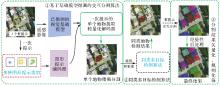
Fig. 2
A minimal-interaction framework for accurate and batch extraction of geospatial objects from remote sensing imagery"


Fig. 3
Interactive segmentation with one interaction based on visual model fine-tuning and cross-attention fusion"


Fig. 4
An identical-class object detection approach integrating image-level and object-level feature similarities"
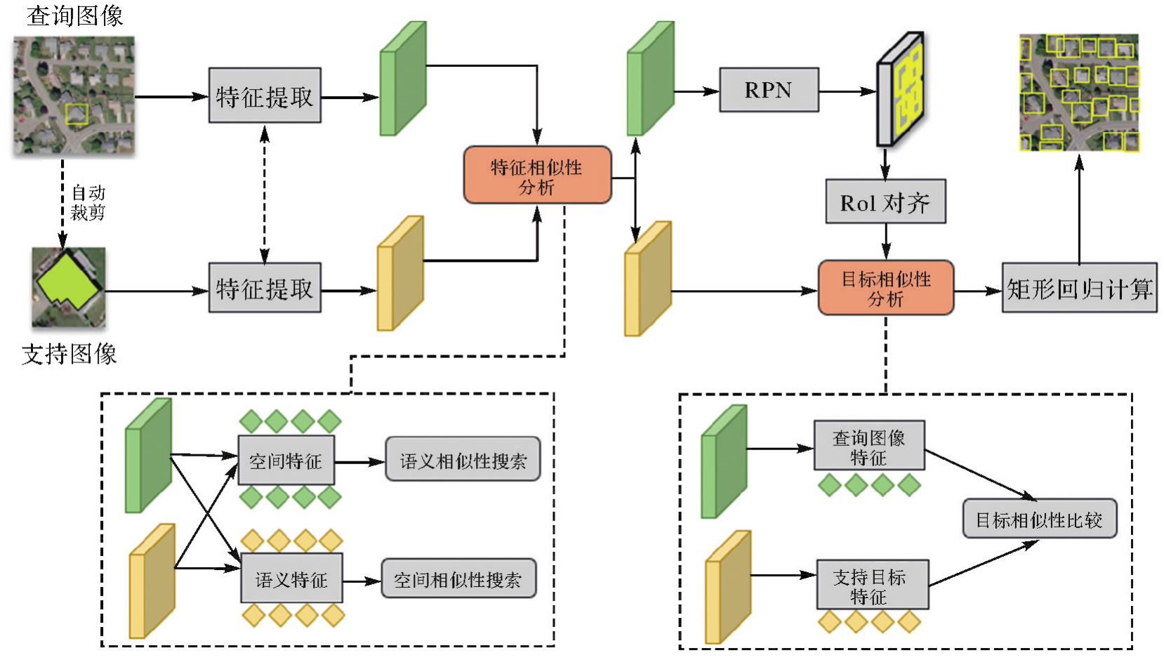

Fig. 5
Post-processing pipeline of vectorization and regularization"

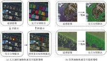
Fig. 6
Workflow of minimalist-interaction-driven intelligent extraction and batch processing of high-resolution remote sensing geo-objects"

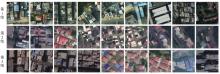
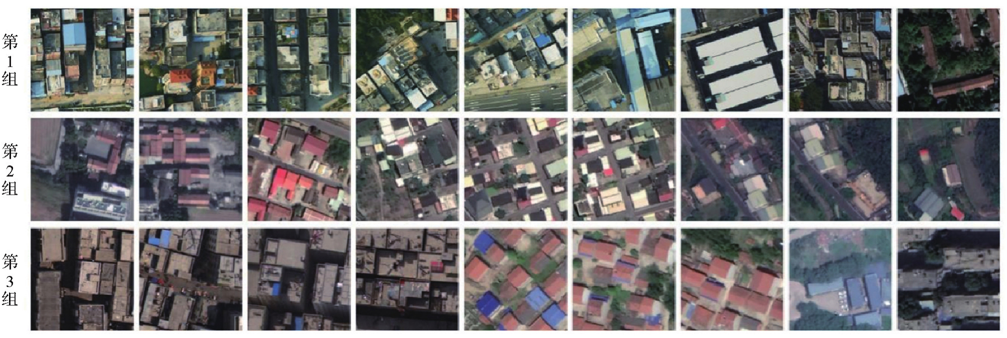
Fig. 7
EVLab building test dataset"
Tab. 1
Performance evaluation on the EVLab building test dataset"
| 方法 | 第1组 | 第2组 | 第3组 | |||
|---|---|---|---|---|---|---|
| 耗时 | IoU/(%) | 耗时 | IoU/(%) | 耗时 | IoU/(%) | |
| SAM | 14 min 47 s | 82.94 | 12 min 38 s | 77.51 | 11 min 17 s | 81.82 |
| EISeg | 14 min 36 s | 85.45 | 10 min 46 s | 77.44 | 47 s 10 min | 83.88 |
| X-AnyLabeling | 16 min 53 s | 86.32 | 11 min 58 s | 76.15 | 9 min 37 s | 85.19 |
| Rein-Lora | 9 min 37 s | 86.59 | 8 min 23 s | 77.52 | 24 s 7 min | 86.91 |
| 本文方法 | 7 min 42 s | 86.85 | 8 min 32 s | 77.45 | 7 min 29 s | 87.61 |
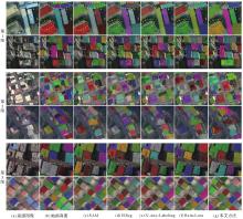
Fig. 8
Comparison of different methods on the EVLab building test dataset"

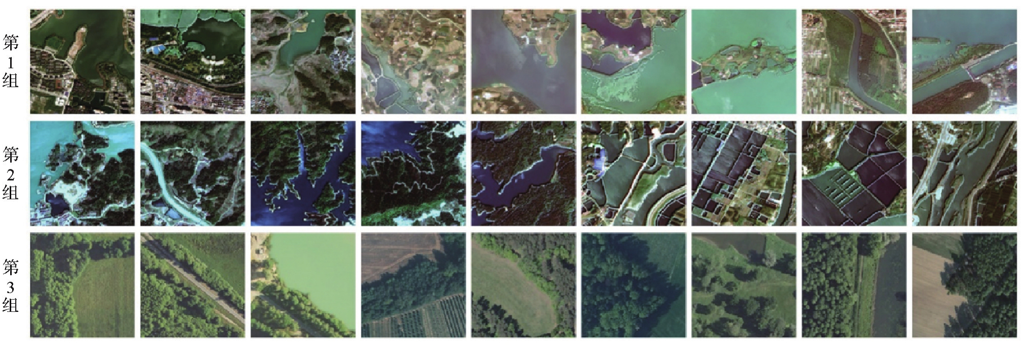
Fig. 9
HBD water-body test dataset and LandCover. ai forest test dataset"
Tab. 2
Performance evaluation on the HBD water-body test dataset and LandCover. ai forest test dataset"
| 方法 | 第1组 | 第2组 | 第3组 | |||
|---|---|---|---|---|---|---|
| 耗时 | IoU/(%) | 耗时 | IoU/(%) | 耗时 | IoU/(%) | |
| SAM | 6 min 38 s | 91.96 | 11 min 45 s | 89.78 | 6 min 37 s | 89.55 |
| EISeg | 7 min 28 s | 91.13 | 10 min 36 s | 84.37 | 12 s 4 min | 86.08 |
| X-AnyLabeling | 5 min 32 s | 91.95 | 9 min 52 s | 84.37 | 5 min 25 s | 87.16 |
| Rein-Lora | 4 min 52 s | 93.78 | 6 min 48 s | 90.13 | 35 s 4 min | 91.25 |
| 本文方法 | 4 min 38 s | 94.24 | 6 min 41 s | 90.38 | 5 min 3 s | 91.33 |

Fig. 10
Comparison of different methods on the HBD water-body test dataset and LandCover. ai forest test dataset"


Fig. 11
Challenges in areal object extraction from remote sensing images"

| [1] |
张兵, 杨晓梅, 高连如, 等. 遥感大数据智能解译的地理学认知模型与方法[J]. 测绘学报, 2022, 51(7): 1398-1415. DOI: .
doi: 10.11947/j.AGCS.2022.20220279 |
|
ZHANG Bing, YANG Xiaomei, GAO Lianru, et al. Geo-cognitive models and methods for intelligent interpretation of remotely sensed big data[J]. Acta Geodaetica et Cartographica Sinica, 2022, 51(7): 1398-1415. DOI: .
doi: 10.11947/j.AGCS.2022.20220279 |
|
| [2] |
李德仁. 展望大数据时代的地球空间信息学[J]. 测绘学报, 2016, 45(4): 379-384. DOI: .
doi: 10.11947/j.AGCS.2016.20160057 |
|
LI Deren. Towards geo-spatial information science in big data era[J]. Acta Geodaetica et Cartographica Sinica, 2016, 45(4): 379-384. DOI: .
doi: 10.11947/j.AGCS.2016.20160057 |
|
| [3] | 龚健雅. 人工智能时代测绘遥感技术的发展机遇与挑战[J]. 武汉大学学报(信息科学版), 2018, 43(12): 1788-1796. |
| GONG Jianya. Chances and challenges for development of surveying and remote sensing in the age of artificial intelligence[J]. Geomatics and Information Science of Wuhan University, 2018, 43(12): 1788-1796. | |
| [4] | BOYKOV Y Y, JOLLY M P. Interactive graph cuts for optimal boundary & region segmentation of objects in N-D images[C]//Proceedings of the 8th IEEE International Conference on Computer Vision. Vancouver: IEEE Computer Society, 2001: 105-112. |
| [5] | ROTHER C, KOLMOGOROV V, BLAKE A. GrabCut: interactive foreground extraction using iterated graph cut[J]. ACM Transactions on Graphics, 2004, 23(3): 309-314. |
| [6] | GRADY L. Random walks for image segmentation[J]. IEEE Transactions on Pattern Analysis and Machine Intelligence, 2006, 28(11): 1768-1783. |
| [7] | XU Ning, PRICE B, COHEN S, et al. Deep interactive object selection[C]//Proceedings of 2016 IEEE Conference on Computer Vision and Pattern Recognition. Las Vegas: IEEE, 2016: 373-381. |
| [8] | LIEW J, WEI Yunchao, XIONG Wei, et al. Regional interactive image segmentation networks[C]//Proceedings of 2017 IEEE International Conference on Computer Vision. Venice: IEEE, 2017: 2746-2754. |
| [9] | LEE K M, MYEONG H, SONG G. SeedNet: automatic seed generation with deep reinforcement learning for robust interactive segmentation[C]//Proceedings of 2018 IEEE/CVF Conference on Computer Vision and Pattern Recognition. Salt Lake City: IEEE, 2018: 1760-1768. |
| [10] | VASWANI A, SHAZEER N, PARMAR N, et al. Attention is all you need[C]//Proceedings of the 31st Conference on Neural Information Processing Systems. Long Beach: NIPS, 2017. |
| [11] | KIRILLOV A, MINTUN E, RAVI N, et al. Segment anything[C]//Proceedings of 2023 IEEE/CVF International Conference on Computer Vision. Paris: IEEE, 2023: 3992-4003. |
| [12] | OSCO L P, WU Qiusheng, DE LEMOS E L, et al. The segment anything model (SAM) for remote sensing applications: from zero to one shot[J]. International Journal of Applied Earth Observation and Geoinformation, 2023, 124: 103540. |
| [13] | HAO Y, LIU Y, CHEN Y, et al. Eiseg: an efficient interactive segmentation tool based on paddlepaddle[EB/OL]. [2025-02-08]. https://arxiv.org/pdf/2210.08788. |
| [14] | WANG Wei. Advanced auto labeling solution with added features[EB/OL]. [2025-02-08]. https://github.com/CVHub520/X-AnyLabeling. |
| [15] | ZHANG Zhili, HU Xiangyun, YANG Yue, et al. High-quality one-shot interactive segmentation for remote sensing images via hybrid adapter-enhanced foundation models[J]. International Journal of Applied Earth Observation and Geoinformation, 2025, 139: 104466. |
| [16] | ZHANG Zhili, XU Jiabo, HU Xiangyun, et al. Faster interactive segmentation of identical-class objects with one mask in high-resolution remotely sensed imagery[J]. IEEE Transactions on Geoscience and Remote Sensing, 2025, 63: 4500516. |
| [17] | ZHANG Zhili, ZHANG Qi, HU Xiangyun, et al. On the automatic quality assessment of annotated sample data for object extraction from remote sensing imagery[J]. ISPRS Journal of Photogrammetry and Remote Sensing, 2023, 201: 153-173. |
| [18] | BOGUSZEWSKI A, BATORSKI D, ZIEMBA-JANKOWSKA N, et al. LandCover. ai: dataset for automatic mapping of buildings, woodlands, water and roads from aerial imagery[C]//Proceedings of 2021 IEEE/CVF Conference on Computer Vision and Pattern Recognition Workshops. Nashville: IEEE, 2021: 1102-1110. |
| [19] | GLOROT X, BENGIO Y. Understanding the difficulty of training deep feedforward neural networks[C]//Proceedings of the 13th International Conference on Artificial Intelligence and Statistics. Sardinia: [s. n.], 2010. |
| [20] | HE Kaiming, ZHANG Xiangyu, REN Shaoqing, et al. Delving deep into rectifiers: surpassing human-level performance on ImageNet classification[C]//Proceedings of 2015 IEEE International Conference on Computer Vision. Santiago: IEEE, 2015: 1026-1034. |
| [21] | KINGMA D P, BA J. Adam: a method for stochastic optimization[C]//Proceedings of 2015 International Conference on Learning Representations. San Diego: ICLR, 2015. |
| [22] | KE Lei, YE Mingqiao, DANELLJAN M, et al. Segment anything in high quality[J]. Advances in Neural Information Processing Systems, 2023, 36: 29914-29934. |
| [23] | WEI Zhixiang, CHEN Lin, JIN Yi, et al. Stronger fewer & superior: harnessing vision foundation models for domain generalized semantic segmentation[C]//Proceedings of 2024 IEEE/CVF Conference on Computer Vision and Pattern Recognition. Seattle: IEEE, 2024. |
| [1] | Jiayao WANG, Lin CHEN, Shiyuan CHENG, Lijun WANG, Siqi XIONG. Artificial intelligence empowering the digital-intelligent transformation of cartographic science [J]. Acta Geodaetica et Cartographica Sinica, 2026, 55(3): 381-389. |
| [2] | Xiaomin LU, Zhiyi ZHANG, Haowen YAN, Yi HE, Xiaoning SU. A recognition method for building group pattern integrating deep graph infomax and multilayer perceptron [J]. Acta Geodaetica et Cartographica Sinica, 2026, 55(3): 425-438. |
| [3] | Shunping JI, Jin LIU, Jian GAO, Jianya GONG. An intelligent 3D reconstruction framework via deep learning based multi-view image matching [J]. Acta Geodaetica et Cartographica Sinica, 2025, 54(9): 1633-1646. |
| [4] | Jixian ZHANG, Haiyan GU, Huan NI, Haitao LI, Yi YANG, Shaopeng DING, Songman SUI. Deep learning methods for remote sensing intelligent change detection: evolution and development [J]. Acta Geodaetica et Cartographica Sinica, 2025, 54(8): 1347-1370. |
| [5] | Shuai FANG, Jiaen LIU, Jing ZHANG. Spatio-temporal fusion algorithm based on adaptive reference feature incorporation and multi-scale feature aggregation [J]. Acta Geodaetica et Cartographica Sinica, 2025, 54(8): 1476-1488. |
| [6] | Nina MENG, Fengmei LI, Xiaodong ZHOU. Data and cognition dual-driven building group generalization results and scale consistency assessment [J]. Acta Geodaetica et Cartographica Sinica, 2025, 54(7): 1318-1331. |
| [7] | Yaqing WANG, Zhonghui WANG. River network automated selection method based on heterogeneous graph convolutional networks [J]. Acta Geodaetica et Cartographica Sinica, 2025, 54(7): 1332-1345. |
| [8] | Xiaoya AN, Weiru GUO, Pengxin ZHANG, Xinxin LI, Lei SHI. Ship trajectories clustering method considering similarity in geometric position and mobility features [J]. Acta Geodaetica et Cartographica Sinica, 2025, 54(6): 1107-1121. |
| [9] | Chao WANG, Tianyu CHEN, Tong ZHANG, Tanvir AHMED, Liqiang JI, Tao XIE, Jiajun YANG, Shuai WANG. Multi-sensor optical remote sensing images change detection based on global differential enhancement module and balance penalty loss [J]. Acta Geodaetica et Cartographica Sinica, 2025, 54(5): 873-887. |
| [10] | Qingli LUO, Xueyan LI, Guoman HUANG, Honghui CHEN, Minglong XUE, Jian LI. AOSN: alpha optimal structure network for height estimation from a single SAR image in mountain areas [J]. Acta Geodaetica et Cartographica Sinica, 2025, 54(5): 888-898. |
| [11] | Wei TU, Xiangyuan CHI, Tianhong ZHAO, Jian YANG, Shiping ZHU, Deli CHEN. Multi-view spatio-temporal graph convolutional networks model for urban drainage networks flow prediction [J]. Acta Geodaetica et Cartographica Sinica, 2025, 54(2): 334-344. |
| [12] | Zhenghua ZHANG, Guoliang CHEN. A lightweight rotation-invariant network for LiDAR-based place recognition [J]. Acta Geodaetica et Cartographica Sinica, 2025, 54(1): 90-103. |
| [13] | Yan SHI, Da WANG, Min DENG, Xuexi YANG. Spatio-temporal anomaly detection: connotation transformation and implementation path from data-driven to knowledge-driven modeling [J]. Acta Geodaetica et Cartographica Sinica, 2024, 53(8): 1493-1504. |
| [14] | Xin YAN, Li SHEN, Junjie PAN, Yanshuai DAI, Jicheng WANG, Xiaoli ZHENG, Zhi-lin LI. Weakly supervised building change detection integrating multi-scale feature fusion and spatial refinement for high resolution remote sensing images [J]. Acta Geodaetica et Cartographica Sinica, 2024, 53(8): 1586-1597. |
| [15] | Jinwei BU, Kegen YU, Qiulan WANG, Linghui LI, Xinyu LIU, Xiaoqing ZUO, Jun CHANG. Deep learning retrieval method for global ocean significant wave height by integrating spaceborne GNSS-R data and multivariable parameters [J]. Acta Geodaetica et Cartographica Sinica, 2024, 53(7): 1321-1335. |
| Viewed | ||||||
|
Full text |
|
|||||
|
Abstract |
|
|||||