

Acta Geodaetica et Cartographica Sinica ›› 2025, Vol. 54 ›› Issue (5): 888-898.doi: 10.11947/j.AGCS.2025.20230431
• Photogrammetry and Remote Sensing • Previous Articles Next Articles
Qingli LUO1( ), Xueyan LI1, Guoman HUANG2, Honghui CHEN1, Minglong XUE1, Jian LI1
Received:2024-09-27
Revised:2025-04-08
Online:2025-06-23
Published:2025-06-23
About author:LUO Qingli (1985—), female, PhD, associate professor, majors in SAR remote sensing and InSAR applications. E-mail: luoqingli@tju.edu.cn
Supported by:CLC Number:
Qingli LUO, Xueyan LI, Guoman HUANG, Honghui CHEN, Minglong XUE, Jian LI. AOSN: alpha optimal structure network for height estimation from a single SAR image in mountain areas[J]. Acta Geodaetica et Cartographica Sinica, 2025, 54(5): 888-898.

Fig. 1
Network structure of IM2HEIGHT"
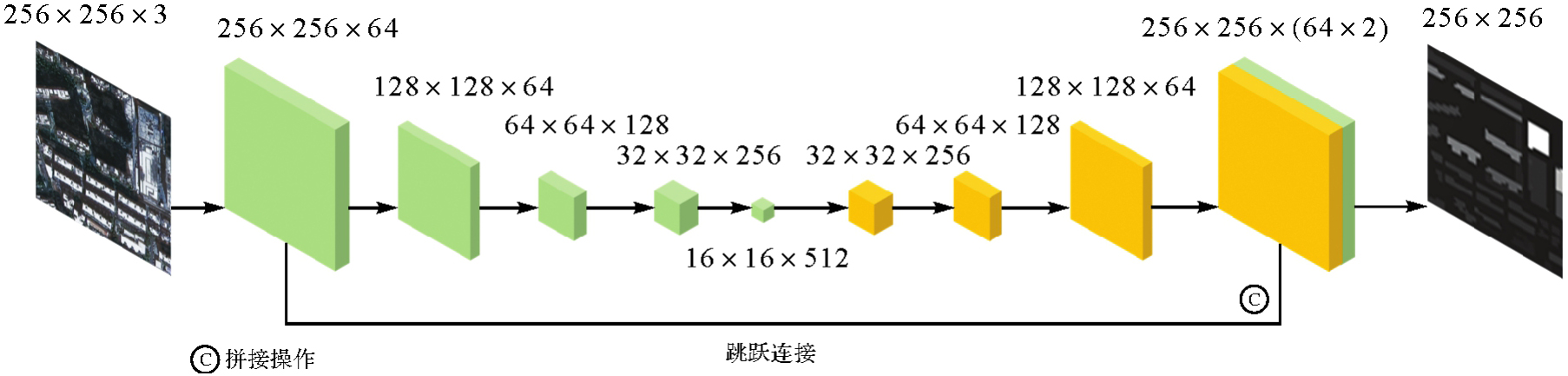
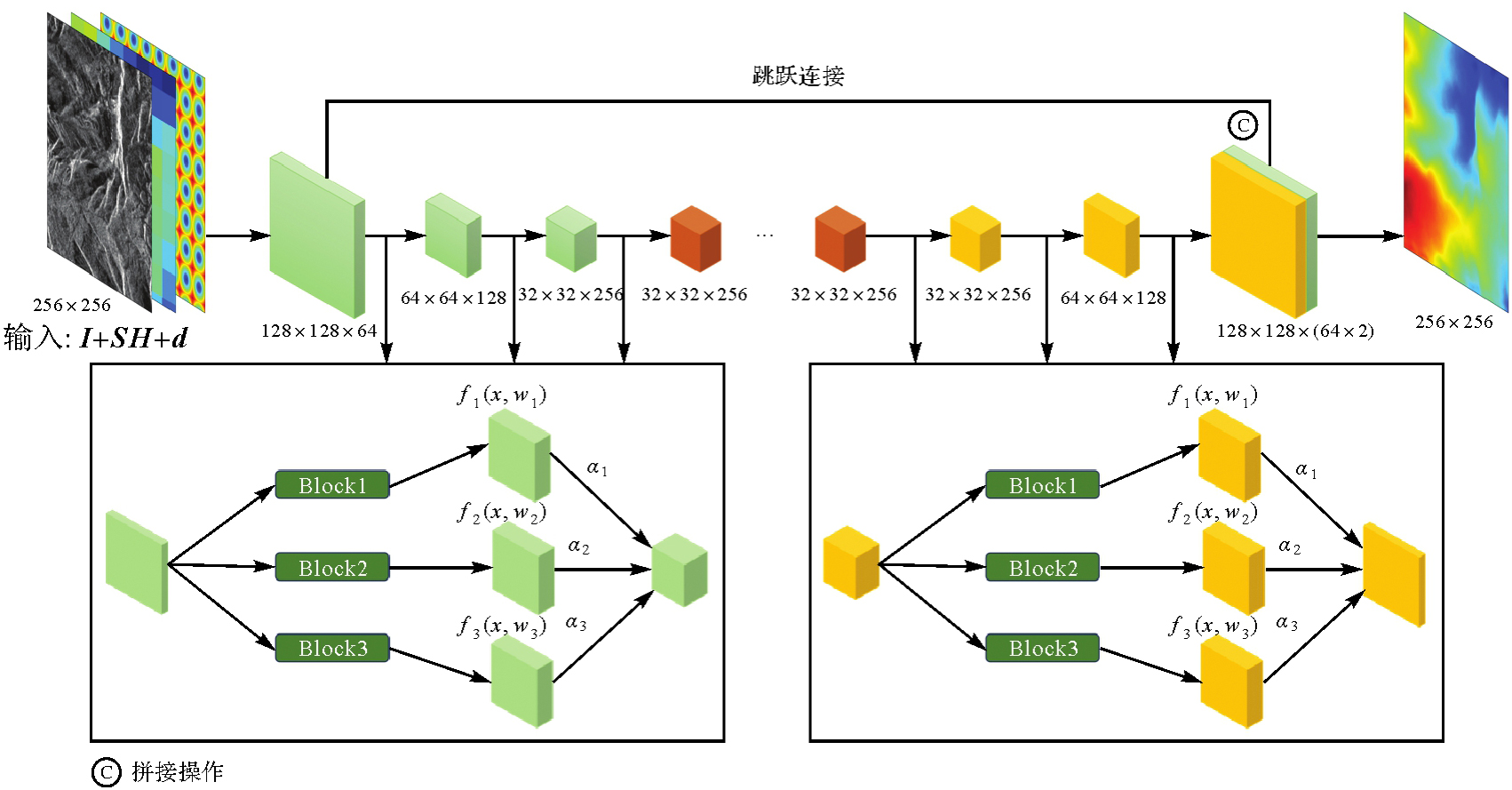
Fig. 2
Network structure of AOSN"
Tab. 1
Network structure details of AOSN"
| 模块 | 层 | 操作 | 输出尺寸 |
|---|---|---|---|
| Input | 拼接 | (256,256,3) | |
| Down1 | 3×3Conv+5×5Conv+Pool | (128,128,64) | |
| Down Block | Down2 | 3×3Conv+5×5Conv+Pool | (64,64,128) |
| Down3 | 3×3Conv+5×5Conv+Pool | (32,32,256) | |
| [Conv1 | Conv | (32,32,512) | |
| 5×[Down Resblocks] | Conv2 | Conv | (32,32,512) |
| Conv3] | Conv | (32,32,256) | |
| [Conv1 | Conv | (32,32,512) | |
| 5×[Up Resblocks] | Conv2 | Conv | (32,32,512) |
| Conv3] | Conv | (32,32,512) | |
| Up1 | 3×3TransConv+5×5 TransConv+Bilinear | (32,32,256) | |
| Up Block | Up2 | 3×3TransConv+5×5 TransConv+Bilinear | (64,64,128) |
| Up3 | 3×3TransConv+5×5 TransConv+Bilinear | (128,128,64) | |
| Output | Out | TransConv | (256,256,1) |
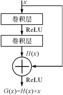
Fig. 3
Structure of residual block"
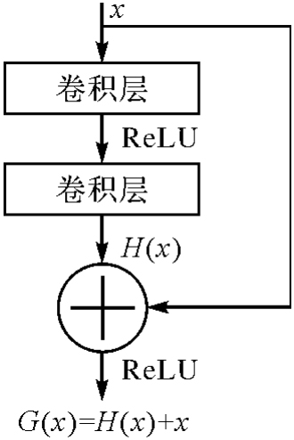
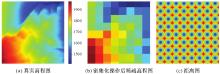
Fig. 4
Sparse height and distance"
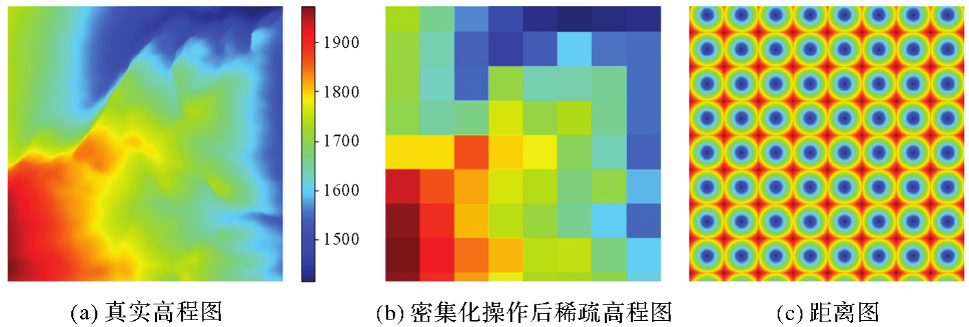
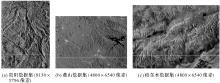
Fig. 5
Experimental datasets"
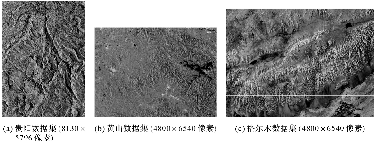
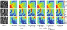
Fig. 6
Results of ablation experiments"

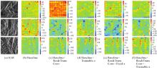
Fig. 7
Errors of ablation experiments"

Tab. 2
Results of ablation experiments"
| 数据集 | 残差模块和转置卷积模块 | 结构参数α | RMSE/m | MAE/m | SSIM |
|---|---|---|---|---|---|
| 贵阳 | N | N | 43.18 | 29.63 | 0.33 |
| Y | N | 36.72 | 24.51 | 0.47 | |
| N | Y,Trainable | 34.81 | 23.77 | 0.54 | |
| Y | Y,Fixed | 28.93 | 20.08 | 0.56 | |
| Y | Y,Trainable | 24.54 | 16.37 | 0.68 | |
| 黄山 | N | N | 49.05 | 33.56 | 0.37 |
| Y | N | 39.92 | 31.09 | 0.42 | |
| N | Y,Trainable | 39.47 | 30.26 | 0.47 | |
| Y | Y,Fixed | 30.10 | 27.64 | 0.49 | |
| Y | Y,Trainable | 26.29 | 21.64 | 0.61 | |
| 格尔木 | N | N | 51.02 | 44.57 | 0.28 |
| Y | N | 46.19 | 39.28 | 0.44 | |
| N | Y,Trainable | 44.16 | 35.80 | 0.52 | |
| Y | Y,Fixed | 36.69 | 32.94 | 0.56 | |
| Y | Y,Trainable | 29.19 | 24.16 | 0.58 |
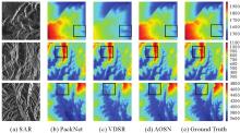
Fig. 8
Results of comparison experiments"
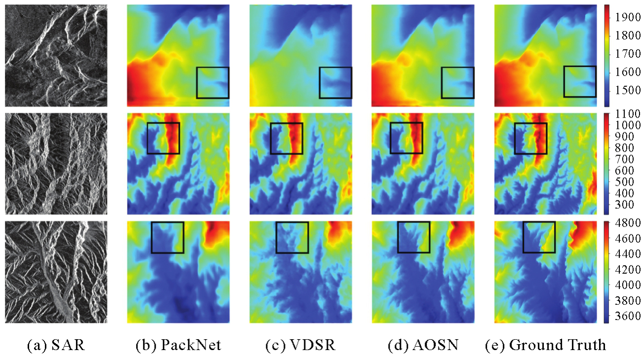
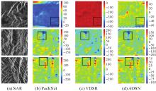
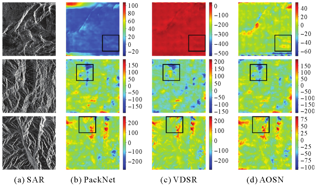
Fig. 9
Errors of comparison experiments"
Tab. 3
Results of comparison experiments with advanced methods"
| 数据集 | 网络 | RMSE/m | MAE/m | SSIM |
|---|---|---|---|---|
| 贵阳 | PackNet | 28.67 | 19.73 | 0.54 |
| VDSR | 31.93 | 23.59 | 0.49 | |
| AOSN | 24.54 | 16.37 | 0.68 | |
| 黄山 | PackNet | 29.48 | 23.19 | 0.57 |
| VDSR | 34.38 | 26.11 | 0.52 | |
| AOSN | 26.29 | 21.64 | 0.61 | |
| 格尔木 | PackNet | 35.58 | 28.53 | 0.51 |
| VDSR | 41.51 | 34.89 | 0.42 | |
| AOSN | 29.19 | 24.16 | 0.58 |
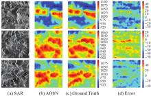
Fig. 10
Test of the generalization ability of AOSN"

Tab. 4
RMSE and SSIM on Geermu testing dataset and Huangshan dataset"
| 数据集 | RMSE/m | SSIM |
|---|---|---|
| 格尔木测试集 | 29.19 | 0.58 |
| 黄山数据集 | 192.25 | 0.31 |
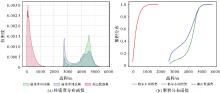
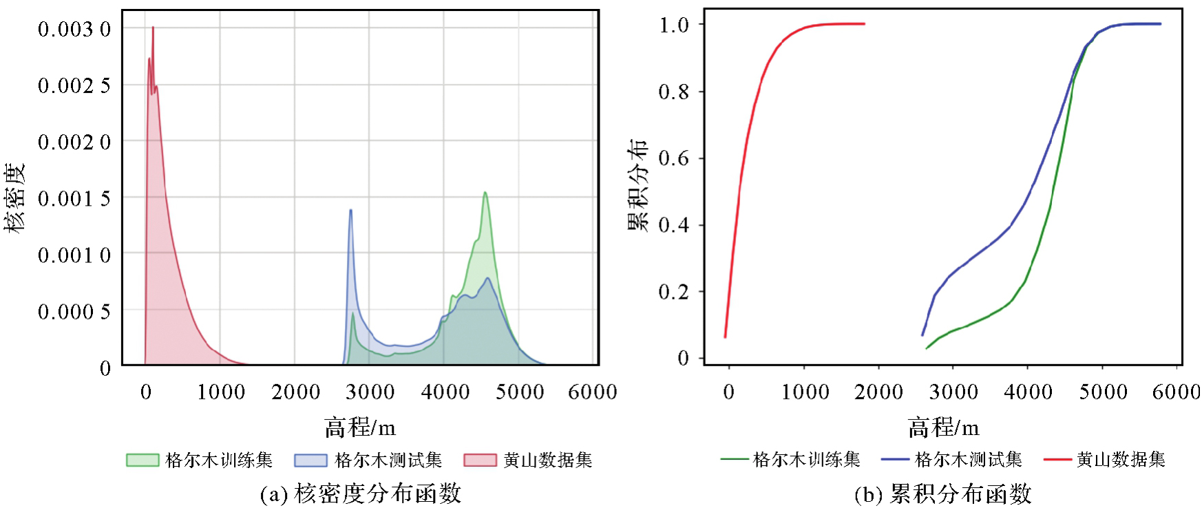
Fig. 11
Kernel density distribution and cumulative distribution function of DEM of Geermu training dataset, testing dataset and Huangshan dataset"
| [1] |
罗卿莉, 崔峰志, 魏钜杰, 等. SAR影像变化检测的前景特征流形排序法[J]. 测绘学报, 2022, 51(11): 2365-2378. DOI: .
doi: 10.11947/j.AGCS.2024.20240040 |
|
LUO Qingli, CUI Fengzhi, WEI Jujie, et al. Foreground feature manifold ranking method for SAR image change detection[J]. Acta Geodaetica et Cartographica Sinica, 2022, 51(11): 2365-2378. DOI: .
doi: 10.11947/j.AGCS.2024.20240040 |
|
| [2] | STUBBS D C, SILWAL L, THUROW B S, et al. Three-dimensional measurement of the crater formation during plume-surface interactions using stereo-photogrammetry[J]. AIAA Journal, 2022, 60(3): 1316-1331. |
| [3] | WU Songbo, ZHANG Bochen, DING Xiaoli, et al. A hybrid method for MT-InSAR phase unwrapping for deformation monitoring in urban areas[J]. International Journal of Applied Earth Observation and Geoinformation, 2022, 112: 102963. |
| [4] | LUO Qingli, LI Jian, ZHANG Yuanzhi. Monitoring subsidence over the planned Jakarta-Bandung (Indonesia) high-speed railway using Sentinel-1 multi-temporal InSAR data[J]. Remote Sensing, 2022, 14(17): 4138. |
| [5] | DANA K J, VAN GINNEKEN B, NAYAR S K, et al. Reflectance and texture of real-world surfaces[J]. ACM Transactions on Graphics, 1999, 18(1): 1-34. |
| [6] | WU B, LIU W C, GRUMPE A, et al. Construction of pixel-level resolution DEMs from monocular images by shape and albedo from shading constrained with low-resolution DEM[J]. ISPRS Journal of Photogrammetry and Remote Sensing, 2018, 140: 3-19. |
| [7] | 张艳超, 庄载椿, 肖宇钊, 等. 基于运动恢复结构算法的油菜NDVI三维分布[J]. 农业工程学报, 2015, 31(17): 207-214. |
| ZHANG Yanchao, ZHUANG Zaichun, XIAO Yuzhao, et al. Rape plant NDVI 3D distribution based on structure from motion[J]. Transactions of the Chinese Society of Agricultural Engineering, 2015, 31(17): 207-214. | |
| [8] | MOULON P, MONASSE P, MARLET R. Adaptive structure from motion with a Contrario model estimation[C]//Proceedings of 2012 Asian Conference on Computer Vision. Berlin: Springer, 2013: 257-270. |
| [9] | SARITAS M M, YASAR A. Performance analysis of ANN and naive Bayes classification algorithm for data classification[J]. International Journal of Intelligent Systems and Applications in Engineering, 2019, 7(2): 88-91. |
| [10] | ZHOU Tinghui, BROWN M, SNAVELY N, et al. Unsupervised learning of depth and ego-motion from video[C]//Proceedings of 2017 IEEE Conference on Computer Vision and Pattern Recognition. Honolulu: IEEE, 2017: 6612-6619. |
| [11] | LIU B Y, GOULD S, KOLLER D. Single image depth estimation from predicted semantic labels[C]//Proceedings of 2010 IEEE Computer Society Conference on Computer Vision and Pattern Recognition. San Francisco: IEEE, 2010: 1253-1260. |
| [12] | SHI Wenzhe, CABALLERO J, HUSZAR F, et al. Real-time single image and video super-resolution using an efficient sub-pixel convolutional neural network[C]//Proceedings of 2016 IEEE Conference on Computer Vision and Pattern Recognition. Las Vegas: IEEE, 2016: 1874-1883. |
| [13] | FAROOQ BHAT S, ALHASHIM I, WONKA P. AdaBins: depth estimation using adaptive bins[C]//Proceedings of 2021 IEEE/CVF Conference on Computer Vision and Pattern Recognition. Nashville: IEEE, 2021: 4008-4017. |
| [14] | REZA M A, KOSECKA J, DAVID P. FarSight: long-range depth estimation from outdoor images[C]//Proceedings of 2018 IEEE/RSJ International Conference on Intelligent Robots and Systems. Madrid: IEEE, 2018: 4751-4757. |
| [15] | CHO J, MIN Dongbo, KIM Y, et al. Deep monocular depth estimation leveraging a large-scale outdoor stereo dataset[J]. Expert Systems with Applications, 2021, 178: 114877. |
| [16] | FENG Qi, SHUM H P H, MORISHIMA S. 360 depth estimation in the wild - the Depth360 dataset and the SegFuse network[C]//Proceedings of 2022 IEEE Conference on Virtual Reality and 3D User Interfaces. Christchurch: IEEE, 2022: 664-673. |
| [17] | YUAN Haobo, LI Xiangtai, YANG Yibo, et al. PolyphonicFormer: unified query learning for depth-aware video panoptic segmentation[C]//Proceedings of 2022 European Conference on Computer Vision. Cham: Springer Nature Switzerland, 2022: 582-599. |
| [18] | KIM J, LEE J K, LEE K M. Accurate image super-resolution using very deep convolutional networks[C]//Proceedings of 2016 IEEE Conference on Computer Vision and Pattern Recognition. Las Vegas: IEEE, 2016: 1646-1654. |
| [19] | GUIZILINI V, AMBRUS R, PILLAI S, et al. 3D packing for self-supervised monocular depth estimation[C]//Proceedings of 2020 IEEE/CVF Conference on Computer Vision and Pattern Recognition. Seattle: IEEE, 2020: 2482-2491. |
| [20] | SRIVASTAVA S, VOLPI M, TUIA D. Joint height estimation and semantic labeling of monocular aerial images with CNNS[C]//Proceedings of 2017 IEEE International Geoscience and Remote Sensing Symposium. Fort Worth: IEEE, 2017: 5173-5176. |
| [21] | MOU Lichao, ZHU Xiaoxiang. IM2HEIGHT: height estimation from single monocular imagery via fully residual convolutional-deconvolutional network[EB/OL]. [2024-02-04]. https://arxiv.org/abs/1802.10249v1. |
| [22] | GHAMISI P, YOKOYA N. IMG2DSM: height simulation from single imagery using conditional generative adversarial net[J]. IEEE Geoscience and Remote Sensing Letters, 2018, 15(5): 794-798. |
| [23] | XUE Minglong, LI Jian, ZHAO Zheng, et al. SAR2HEIGHT: height estimation from a single SAR image in mountain areas via sparse height and proxyless depth-aware penalty neural architecture search for Unet[J]. Remote Sensing, 2022, 14(21): 5392. |
| [24] | RONNEBERGER O, FISCHER P, BROX T. U-Net: convolutional networks for biomedical image segmentation[C]//Proceedings of 2015 International Conference on Medical Image Computing and Computer-Assisted Intervention. Cham: Springer International Publishing, 2015: 234-241. |
| [25] | XUE Minglong, LI Jian, LUO Qingli. A geometry-aware consistent constraint for height estimation from a single SAR imagery in mountain areas[J]. IEEE Geoscience and Remote Sensing Letters, 2023, 20: 1-5. |
| [1] | Jiayao WANG, Lin CHEN, Shiyuan CHENG, Lijun WANG, Siqi XIONG. Artificial intelligence empowering the digital-intelligent transformation of cartographic science [J]. Acta Geodaetica et Cartographica Sinica, 2026, 55(3): 381-389. |
| [2] | Xiaomin LU, Zhiyi ZHANG, Haowen YAN, Yi HE, Xiaoning SU. A recognition method for building group pattern integrating deep graph infomax and multilayer perceptron [J]. Acta Geodaetica et Cartographica Sinica, 2026, 55(3): 425-438. |
| [3] | Bin HAN, Xin HUANG, Fengyi LI, Xiaozhen LU. Water body segmentation network for SAR images combining dual-encoder and adaptive feature fuse [J]. Acta Geodaetica et Cartographica Sinica, 2026, 55(1): 101-113. |
| [4] | Shunping JI, Jin LIU, Jian GAO, Jianya GONG. An intelligent 3D reconstruction framework via deep learning based multi-view image matching [J]. Acta Geodaetica et Cartographica Sinica, 2025, 54(9): 1633-1646. |
| [5] | Jixian ZHANG, Haiyan GU, Huan NI, Haitao LI, Yi YANG, Shaopeng DING, Songman SUI. Deep learning methods for remote sensing intelligent change detection: evolution and development [J]. Acta Geodaetica et Cartographica Sinica, 2025, 54(8): 1347-1370. |
| [6] | Shuai FANG, Jiaen LIU, Jing ZHANG. Spatio-temporal fusion algorithm based on adaptive reference feature incorporation and multi-scale feature aggregation [J]. Acta Geodaetica et Cartographica Sinica, 2025, 54(8): 1476-1488. |
| [7] | Nina MENG, Fengmei LI, Xiaodong ZHOU. Data and cognition dual-driven building group generalization results and scale consistency assessment [J]. Acta Geodaetica et Cartographica Sinica, 2025, 54(7): 1318-1331. |
| [8] | Yaqing WANG, Zhonghui WANG. River network automated selection method based on heterogeneous graph convolutional networks [J]. Acta Geodaetica et Cartographica Sinica, 2025, 54(7): 1332-1345. |
| [9] | Xiaoya AN, Weiru GUO, Pengxin ZHANG, Xinxin LI, Lei SHI. Ship trajectories clustering method considering similarity in geometric position and mobility features [J]. Acta Geodaetica et Cartographica Sinica, 2025, 54(6): 1107-1121. |
| [10] | Chao WANG, Tianyu CHEN, Tong ZHANG, Tanvir AHMED, Liqiang JI, Tao XIE, Jiajun YANG, Shuai WANG. Multi-sensor optical remote sensing images change detection based on global differential enhancement module and balance penalty loss [J]. Acta Geodaetica et Cartographica Sinica, 2025, 54(5): 873-887. |
| [11] | Wei TU, Xiangyuan CHI, Tianhong ZHAO, Jian YANG, Shiping ZHU, Deli CHEN. Multi-view spatio-temporal graph convolutional networks model for urban drainage networks flow prediction [J]. Acta Geodaetica et Cartographica Sinica, 2025, 54(2): 334-344. |
| [12] | Zhili ZHANG, Huiwei JIANG, Xiangyun HU. A minimal-interaction framework for accurate and batch extraction of geospatial objects from remote sensing imagery [J]. Acta Geodaetica et Cartographica Sinica, 2025, 54(10): 1863-1876. |
| [13] | Zhenghua ZHANG, Guoliang CHEN. A lightweight rotation-invariant network for LiDAR-based place recognition [J]. Acta Geodaetica et Cartographica Sinica, 2025, 54(1): 90-103. |
| [14] | Yan SHI, Da WANG, Min DENG, Xuexi YANG. Spatio-temporal anomaly detection: connotation transformation and implementation path from data-driven to knowledge-driven modeling [J]. Acta Geodaetica et Cartographica Sinica, 2024, 53(8): 1493-1504. |
| [15] | Xin YAN, Li SHEN, Junjie PAN, Yanshuai DAI, Jicheng WANG, Xiaoli ZHENG, Zhi-lin LI. Weakly supervised building change detection integrating multi-scale feature fusion and spatial refinement for high resolution remote sensing images [J]. Acta Geodaetica et Cartographica Sinica, 2024, 53(8): 1586-1597. |
| Viewed | ||||||
|
Full text |
|
|||||
|
Abstract |
|
|||||