

Acta Geodaetica et Cartographica Sinica ›› 2026, Vol. 55 ›› Issue (4): 618-631.doi: 10.11947/j.AGCS.2026.20250409
• Coastal and Marine Surveying, Mapping, and Remote Sensing • Previous Articles Next Articles
Lanxin WU1,2( ), Jiangtao PENG1,2, Weiwei SUN3,4,5(), Bing YANG5,6
Received:2025-09-30
Revised:2026-03-13
Online:2026-05-11
Published:2026-05-11
Contact:
Weiwei SUN
E-mail:hubulanxinwu@163.com;sunweiwei@nbu.edu.cn
About author:WU Lanxin (2000—), male, master, majors in coastal hyperspectral remote sensing. E-mail: hubulanxinwu@163.com
Supported by:CLC Number:
Lanxin WU, Jiangtao PENG, Weiwei SUN, Bing YANG. An Euler embedding and complementary feature modeling framework for hyperspectral change detection in coastal wetlands[J]. Acta Geodaetica et Cartographica Sinica, 2026, 55(4): 618-631.
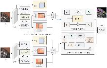
Fig. 1
Overall framework of the Euler embedding and complementary feature modeling method for coastal remote sensing change detection"
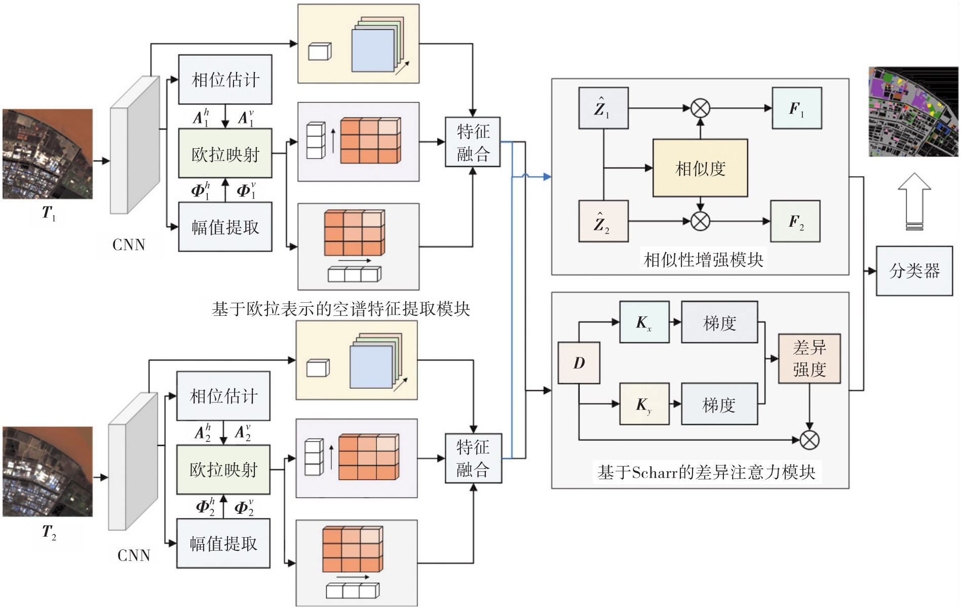
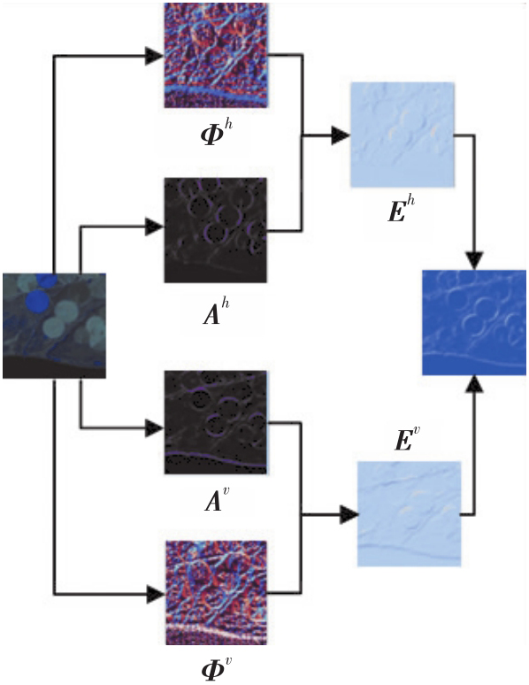
Fig. 2
Schematic illustration of ETSS module structure and workflow"
Tab. 1
Detailed information of three datasets"
| 数据集 | 图像尺寸/像素 | 通道数 | 采集时间 | 传感器 | |
|---|---|---|---|---|---|
| 图像1 | 图像2 | ||||
| USA-Hermiston | 307×241 | 154 | 2004-05-01 | 2007-05-08 | Hyperion |
| HZB | 400×400 | 166 | 2021-01-29 | 2022-02-27 | ZY-02D |
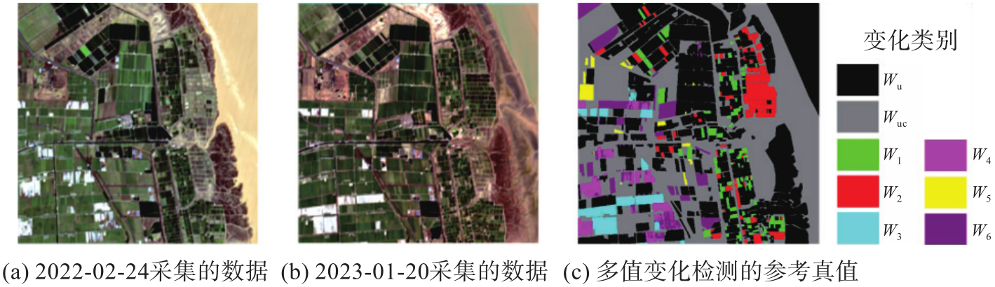
| Yancheng | 512×512 | 166 | 2022-02-24 | 2023-01-20 | ZY-02D |
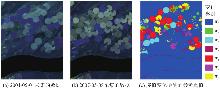
Fig. 3
USA-Hermiston dataset"
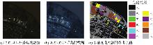
Fig. 4
HZB dataset"
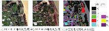
Fig. 5
Yancheng dataset"
Tab. 2
Multi-class change detection accuracy of different methods on USA-Hermiston dataset"
| 方法 | 变化类别准确率 | OA | AA | κ | ||||||
|---|---|---|---|---|---|---|---|---|---|---|
| 未变化 | 1 | 2 | 3 | 4 | 5 | 6 | ||||
| Re3FCN | 97.69±0.45 | 0.00±0.00 | 0.00±0.00 | 37.61±21.83 | 91.65±4.58 | 0.00±0.00 | 37.96±30.71 | 83.26±0.34 | 28.61±1.95 | 52.21±1.53 |
| BIT | 97.37±0.74 | 29.41±5.64 | 78.45±7.40 | 46.62±6.36 | 85.55±0.59 | 42.89±3.37 | 45.21±9.37 | 89.68±0.55 | 60.80±3.09 | 72.28±1.72 |
| ConvLSTM | 98.45±0.53 | 0.00±0.00 | 4.52±2.97 | 0.00±0.00 | 86.56±7.32 | 0.00±0.00 | 10.68±5.34 | 84.49±0.77 | 31.71±4.86 | 54.45±4.30 |
| GLAFormer | 96.96±0.51 | 22.23±5.91 | 69.28±2.96 | 30.32±8.85 | 78.91±5.03 | 38.21±5.50 | 33.82±7.30 | 87.38±0.69 | 52.82±2.09 | 66.14±1.79 |
| BTCDNet | 97.63±0.73 | 0.00±0.00 | 23.17±13.37 | 10.22±8.57 | 84.50±6.12 | 0.13±0.07 | 14.60±10.85 | 83.47±1.08 | 30.95±5.47 | 47.29±5.18 |
| BT-SCD | 96.91±1.07 | 42.19±11.91 | 57.81±7.65 | 38.68±5.54 | 82.14±4.27 | 34.27±12.47 | 51.35±5.72 | 88.38±1.19 | 57.63±0.92 | 68.77±2.39 |
| EECFM | 97.95±0.28 | 43.22±4.03 | 80.53±2.01 | 54.11±3.24 | 91.82±0.09 | 55.75±7.17 | 60.95±0.14 | 92.11±0.12 | 69.19±0.60 | 78.97±0.18 |
Fig. 6
Multi-class change detection results of USA-Hermiston dataset"
Tab. 3
Multi-class change detection accuracy of different methods on HZB dataset"
| 方法 | 变化类别准确率 | OA | AA | κ | |||||||||
|---|---|---|---|---|---|---|---|---|---|---|---|---|---|
| 未变化 | 1 | 2 | 3 | 4 | 5 | 6 | 7 | 8 | 9 | ||||
| Re3FCN | 98.42±0.41 | 0.00±0.00 | 0.00±0.00 | 0.00±0.00 | 0.00±0.00 | 63.76±3.24 | 11.48±8.15 | 0.00±0.00 | 91.58±0.95 | 0.00±0.00 | 89.90±0.13 | 26.92±1.65 | 68.63±0.43 |
| BIT | 98.64±0.08 | 96.09±2.71 | 100.00±0.00 | 50.19±8.08 | 63.52±1.10 | 76.20±3.28 | 61.81±4.36 | 64.17±12.79 | 85.84±2.82 | 49.47±12.57 | 93.84±0.47 | 74.60±2.97 | 81.27±1.64 |
| ConvLSTM | 98.63±0.58 | 0.00±0.00 | 0.00±0.00 | 0.00±0.00 | 0.00±0.00 | 65.92±19.48 | 0.00±0.00 | 0.00±0.00 | 94.85±1.19 | 0.00±0.00 | 90.19±1.09 | 25.94±1.93 | 68.51±5.32 |
| GLAFormer | 96.67±0.22 | 87.07±8.97 | 77.36±6.54 | 27.15±9.91 | 39.09±6.62 | 69.66±2.07 | 49.60±1.92 | 36.10±1.15 | 84.07±3.34 | 39.49±13.68 | 90.66±0.33 | 60.62±1.56 | 72.12±1.23 |
| BTCDNet | 98.05±0.22 | 55.77±8.40 | 64.78±6.11 | 0.00±0.00 | 0.73±0.42 | 64.69±13.38 | 2.59±1.50 | 32.76±19.48 | 84.36±13.21 | 27.30±5.46 | 89.47±1.33 | 41.64±2.34 | 65.02±6.22 |
| BT-SCD | 97.84±0.03 | 92.67±5.28 | 95.27±1.33 | 58.67±6.88 | 78.31±3.93 | 75.01±1.38 | 60.16±0.43 | 64.32±1.82 | 90.61±4.19 | 62.36±8.40 | 93.89±0.24 | 77.53±1.13 | 82.15±0.89 |
| EECFM | 98.86±0.14 | 85.37±4.87 | 93.08±8.91 | 61.28±6.04 | 74.92±4.21 | 80.83±3.23 | 70.96±6.61 | 72.59±5.33 | 93.58±2.45 | 68.50±12.31 | 95.62±0.19 | 82.72±5.85 | 86.94±0.58 |
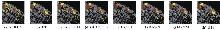
Fig. 7
Multi-class change detection results of HZB dataset"
Tab. 4
Multi-class change detection accuracy of different methods on Yancheng dataset"
| 方法 | 变化类别准确率 | OA | AA | κ | ||||||
|---|---|---|---|---|---|---|---|---|---|---|
| 未变化 | 1 | 2 | 3 | 4 | 5 | 6 | ||||
| Re3FCN | 97.20±0.12 | 49.39±10.51 | 79.56±6.01 | 86.50±2.82 | 65.79±6.99 | 48.90±9.12 | 79.36±4.45 | 90.06±0.56 | 72.33±0.23 | 78.71±1.12 |
| BIT | 98.68±0.22 | 50.82±18.11 | 65.86±18.46 | 55.24±10.48 | 71.83±9.02 | 71.19±4.22 | 77.99±0.67 | 89.19±1.25 | 70.24±2.94 | 76.82±2.63 |
| ConvLSTM | 97.91±0.67 | 72.98±4.98 | 92.48±2.94 | 96.89±0.40 | 86.05±4.93 | 31.80±17.26 | 84.04±2.54 | 90.40±5.57 | 78.79±3.63 | 86.83±1.14 |
| GLAFormer | 97.14±0.39 | 66.69±5.18 | 82.85±3.51 | 90.97±2.43 | 82.02±1.82 | 71.10±0.21 | 78.61±1.40 | 92.14±0.32 | 81.34±1.27 | 83.29±0.78 |
| BTCDNet | 97.59±0.44 | 51.00±6.60 | 83.59±3.80 | 83.26±5.16 | 61.60±15.15 | 3.68±1.65 | 80.90±6.31 | 89.78±1.29 | 65.66±3.72 | 77.89±2.68 |
| BT-SCD | 98.08±0.25 | 67.93±2.17 | 83.06±2.13 | 95.30±0.49 | 90.21±3.24 | 80.63±1.65 | 77.79±1.22 | 93.27±0.03 | 84.72±0.76 | 86.01±0.17 |
| EECFM | 98.76±0.23 | 79.18±1.94 | 90.22±1.58 | 96.90±0.72 | 85.55±3.65 | 87.26±4.59 | 88.31±1.68 | 95.90±0.09 | 90.64±0.56 | 91.01±0.19 |
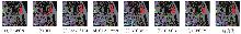
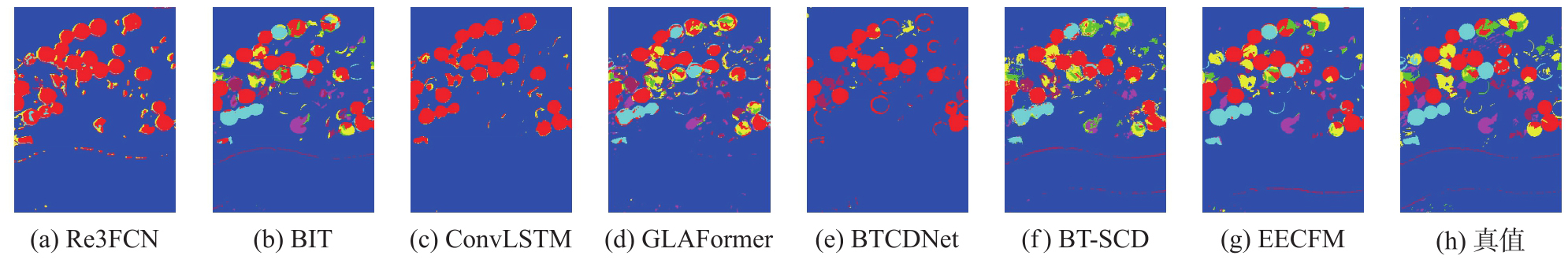
Fig. 8
Multi-class change detection results of different methods on the Yancheng dataset"
Tab. 5
Ablation study settings and accuracy evaluation results"
| 组别 | 模块 | 数据集 | ||||||||||
|---|---|---|---|---|---|---|---|---|---|---|---|---|
| USA-Hermiston | HZB | Yancheng | ||||||||||
| ETSS | BSE+SDA | L | OA | AA | κ | OA | AA | κ | OA | AA | κ | |
| 1 | × | × | × | 88.10 | 43.92 | 65.04 | 93.65 | 67.21 | 80.67 | 94.01 | 86.12 | 88.12 |
| 2 | √ | × | × | 90.27 | 62.44 | 73.34 | 94.87 | 80.89 | 84.85 | 95.09 | 85.96 | 89.41 |
| 3 | √ | × | √ | 90.95 | 65.10 | 75.52 | 94.73 | 75.95 | 84.12 | 95.29 | 89.20 | 89.82 |
| 4 | × | √ | √ | 89.84 | 59.33 | 72.88 | 94.86 | 76.85 | 93.62 | 95.42 | 89.75 | 90.81 |
| 5 | √ | √ | × | 91.19 | 66.58 | 76.89 | 95.25 | 81.29 | 85.85 | 95.67 | 90.26 | 90.91 |
| 6 | √ | √ | √ | 92.11 | 69.19 | 78.97 | 95.62 | 82.72 | 96.94 | 95.90 | 90.64 | 91.01 |
Tab. 6
Computational complexity analysis on the Yancheng dataset"
| 方法 | FLOPs/亿次 | 参数量/万个 |
|---|---|---|
| Re3FCN | 8.91 | 28.94 |
| BIT | 134.53 | 1 644.58 |
| ConvLSTM | 44.18 | 27.69 |
| GLAFormer | 1 018.37 | 1 303.90 |
| BTCDNet | 40.29 | 157.50 |
| BT-SCD | 226.86 | 2 543.61 |
| EECFM | 17.58 | 70.05 |
Tab. 7
Comparison of overall accuracy of different edge operators across datasets"
| 算子 | USA-Hermiston | HZB | Yancheng |
|---|---|---|---|
| Prewitt | 91.55 | 95.04 | 95.52 |
| Sobel | 91.47 | 95.32 | 95.66 |
| Scharr | 92.11 | 95.62 | 95.90 |
| [1] | 王宗明, 颜洋洋, 赵传朋, 等. 滨海湿地遥感研究进展与展望[J]. 遥感学报, 2025, 29(6): 1938-1962. |
| WANG Zongming, YAN Yangyang, ZHAO Chuanpeng, et al. Advances and perspectives in coastal wetland remote sensing research[J]. National Remote Sensing Bulletin, 2025, 29(6): 1938-1962. | |
| [2] | HAN Zheng, LING Ziyan, DONG Li, et al. Heterogeneity effect of human disturbances on landscape patterns in the Yellow River Delta wetland, China[J]. Journal of Geodesy and Geoinformation Science, 2024, 7(4): 75-93. |
| [3] | 薛曌娜, 王毅勇, 霍轩琳, 等. 小微湿地遥感分类和解译研究进展[J]. 遥感信息, 2025, 40(2): 1-10. |
| XUE Zhaona, WANG Yiyong, HUO Xuanlin, et al. Research progress on remote sensing classification and interpretation of small and micro wetlands[J]. Remote Sensing Information, 2025, 40(2): 1-10. | |
| [4] | 顾容, 张东, 钱林峰, 等. GEE平台下考虑潮位变化及植被物候特征的盐城滨海湿地精细化遥感分类[J]. 海洋学报, 2024, 46(5): 103-115. |
| GU Rong, ZHANG Dong, QIAN Linfeng, et al. Refined remote sensing classification of Yancheng coastal wetland considering tide-level changes and vegetation phenological characteristics on the GEE platform[J]. Acta Oceanologica Sinica, 2024, 46(5): 103-115. | |
| [5] | 杨漫, 刘恩勤, 杨扬, 等. 基于Landsat时间序列遥感影像的若尔盖高原湿地演变特征及其驱动因子定量分析[J]. 环境科学, 2025, 46(7): 4461-4472. |
| YANG Man, LIU Enqin, YANG Yang, et al. Quantitative analysis of wetland evolution characteristics and driving factors in Ruoergai Plateau based on landsat time series remote sensing images[J]. Environmental Science, 2025, 46(7): 4461-4472. | |
| [6] | YANG Bing, PAN Shirui, SUN Weiwei, et al. FCFDA: fine-coarse-fine progressive graph framework with distribution alignment for hyperspectral image change detection[J]. IEEE Transactions on Geoscience and Remote Sensing, 2024, 62: 5538714. |
| [7] | QUINTERO-CAMPOS P, SALVADOR-CLAVELL R, MARTÍN B, et al. Environmental monitoring of a climate change indicator (Vibrio vulnificus) in coastal wetland water samples based on field-deployable detection[J]. Science of the Total Environment, 2025, 986: 179791. |
| [8] | 杜培军, 方宏, 郭山川, 等. 深度学习遥感变化检测研究进展:像素—对象—场景[J]. 遥感技术与应用, 2025, 40(4): 783-794. |
| DU Peijun, FANG Hong, GUO Shanchuan, et al. Research progress of remote sensing change detection based on deep learning: pixel-level, object-level, and scene-level[J]. Remote Sensing Technology and Application, 2025, 40(4): 783-794. | |
| [9] | ZHANG Xinyu, CHEN Haihua, ZHAO Yanzhi, et al. Change detection of buildings in remote sensing images using a spatially and contextually aware Siamese network[J]. Expert Systems with Applications, 2025, 276: 127110. |
| [10] | LIU Wensong, JI Xinyuan, LIU Jie, et al. A novel unsupervised change detection method with structure consistency and GFLICM based on UAV images[J]. Journal of Geodesy and Geoinformation Science, 2022, 5(1): 91-102. |
| [11] |
张继贤, 顾海燕, 倪欢, 等. 遥感智能变化检测的深度学习方法:演变与发展趋势[J]. 测绘学报, 2025, 54(8): 1347-1370. DOI: .
doi: 10.11947/j.AGCS.2025.20240417 |
|
ZHANG Jixian, GU Haiyan, NI Huan, et al. Deep learning methods for remote sensing intelligent change detection: evolution and development[J]. Acta Geodaetica et Cartographica Sinica, 2025, 54(8): 1347-1370. DOI: .
doi: 10.11947/j.AGCS.2025.20240417 |
|
| [12] | PENG Jiangtao, SUN Weiwei, LI Hengchao, et al. Low-rank and sparse representation for hyperspectral image processing: a review[J]. IEEE Geoscience and Remote Sensing Magazine, 2022, 10(1): 10-43. |
| [13] | CHEN Yurong, WANG Yaonan, WANG Xiaodong, et al. LCTC: lightweight convolutional thresholding sparse coding network prior for compressive hyperspectral imaging[J]. IEEE Transactions on Image Processing, 2025, 34: 4286-4301. |
| [14] | KıLıÇ D K, NIELSEN P. Comparative analyses of unsupervised PCA K-means change detection algorithm from the viewpoint of follow-up plan[J]. Sensors, 2022, 22(23): 9172. |
| [15] |
赵金奇, 李宇轩, 刘子蓉, 等. 基于相似性衡量函数优化的SAR时空极化信息一体化洪涝变化检测方法[J]. 测绘学报, 2024, 53(12): 2375-2390. DOI: .
doi: 10.11947/j.AGCS.2024.20230355 |
|
ZHAO Jinqi, LI Yuxuan, LIU Zirong, et al. Flood change detection method using optimized similarity measurement function with temporal-spatial-polarized SAR information[J]. Acta Geodaetica et Cartographica Sinica, 2024, 53(12): 2375-2390. DOI: .
doi: 10.11947/j.AGCS.2024.20230355 |
|
| [16] | BOVOLO F, BRUZZONE L. A theoretical framework for unsupervised change detection based on change vector analysis in the polar domain[J]. IEEE Transactions on Geoscience and Remote Sensing, 2007, 45(1): 218-236. |
| [17] | NIELSEN A A. The regularized iteratively reweighted MAD method for change detection in multi-and hyperspectral data[J]. IEEE Transactions on Image Processing, 2007, 16(2): 463-478. |
| [18] | CELIK T. Unsupervised change detection in satellite images using principal component analysis and K-means clustering[J]. IEEE Geoscience and Remote Sensing Letters, 2009, 6(4): 772-776. |
| [19] | BOVOLO F, MARCHESI S, BRUZZONE L. A framework for automatic and unsupervised detection of multiplechanges in multitemporal images[J]. IEEE Transactions on Geoscience and Remote Sensing, 2012, 50(6): 2196-2212. |
| [20] | BI Yaxin, CHRISTODOULOU V, WILKIE G, et al. Automatic anomaly detection for Swarm observations[J]. Journal of Geodesy and Geoinformation Science, 2021, 4(1): 94-108. |
| [21] | 李相潭, 高峰, 孙悦, 等. 针对高光谱遥感图像变化检测的混合注意力和双向门控网络[J]. 中国图象图形学报, 2025, 30(4): 1017-1026. |
| LI Xiangtan, GAO Feng, SUN Yue, et al. Hybrid attention and bidirectional-gated network for hyperspectral image change detection[J]. Journal of Image and Graphics, 2025, 30(4): 1017-1026. | |
| [22] | MOU Lichao, BRUZZONE L, ZHU Xiaoxiang. Learning spectral-spatial-temporal features via a recurrent convolutional neural network for change detection in multispectral imagery[J]. IEEE Transactions on Geoscience and Remote Sensing, 2019, 57(2): 924-935. |
| [23] | LIN Yun, LI Shutao, FANG Leyuan, et al. Multispectral change detection with bilinear convolutional neural networks[J]. IEEE Geoscience and Remote Sensing Letters, 2020, 17(10): 1757-1761. |
| [24] | WU Lanxin, MA Lei, PENG Jiangtao, et al. DIEFEN: differential information-enhanced feature exchange network for hyperspectral change detection[J]. IEEE Transactions on Geoscience and Remote Sensing, 2024, 62: 5533312. |
| [25] |
董子博, 王竞雪, 卜丽静, 等. MAFNet:基于多尺度空洞融合网络的遥感影像建筑物提取方法[J]. 测绘学报, 2025, 54(6): 1094-1106. DOI: .
doi: 10.11947/j.AGCS.2025.20240439 |
|
DONG Zibo, WANG Jingxue, BU Lijing, et al. MAFNet: building extraction method from remote sensing images based on multiscale atrous fusion network[J]. Acta Geodaetica et Cartographica Sinica, 2025, 54(6): 1094-1106. DOI: .
doi: 10.11947/j.AGCS.2025.20240439 |
|
| [26] | SONG A, CHOI J, HAN Y, et al. Change detection in hyperspectral images using recurrent 3D fully convolutional networks[J]. Remote Sensing, 2018, 10(11): 1827. |
| [27] | YANG Bing, SUN Weiwei, PENG Jiangtao. SAGN: sharpening-aware graph network for hyperspectral image change detection[J]. IEEE Transactions on Geoscience and Remote Sensing, 2024, 62: 5518812. |
| [28] |
王超, 陈天宇, 张同, 等. 基于全局差分增强模块和平衡惩罚损失的多源光学遥感影像变化检测[J]. 测绘学报, 2025, 54(5): 873-887. DOI: .
doi: 10.11947/j.AGCS.2025.20240300 |
|
WANG Chao, CHEN Tianyu, ZHANG Tong, et al. Multi-sensor optical remote sensing image change detection based on global differential enhancement module and balance penalty loss[J]. Acta Geodaetica et Cartographica Sinica, 2025, 54(5): 873-887. DOI: .
doi: 10.11947/j.AGCS.2025.20240300 |
|
| [29] | WANG Qi, YUAN Zhenghang, DU Qian, et al. GETNET: a general end-to-end 2-D CNN framework for hyperspectral image change detection[J]. IEEE Transactions on Geoscience and Remote Sensing, 2019, 57(1): 3-13. |
| [30] | OU Xianfeng, LIU Liangzhen, TU Bing, et al. A CNN framework with slow-fast band selection and feature fusion grouping for hyperspectral image change detection[J]. IEEE Transactions on Geoscience and Remote Sensing, 2022, 60: 5524716. |
| [31] | SHI Changjiang, ZHANG Zhijie, ZHANG Wanchang, et al. Learning multiscale temporal-spatial-spectral features via a multipath convolutional LSTM neural network for change detection with hyperspectral images[J]. IEEE Transactions on Geoscience and Remote Sensing, 2022, 60: 5529816. |
| [32] | CHEN Hao, QI Zipeng, SHI Zhenwei. Remote sensing image change detection with transformers[J]. IEEE Transactions on Geoscience and Remote Sensing, 2022, 60: 5607514. |
| [33] | WANG Ziyi, GAO Feng, DONG Junyu, et al. Global and local attention-based transformer for hyperspectral image change detection[J]. IEEE Geoscience and Remote Sensing Letters, 2025, 22: 5500405. |
| [34] |
龚良雄, 李星华, 程远明, 等. 时空差异增强与自适应特征融合的轻量级遥感影像变化检测网络[J]. 测绘学报, 2025, 54(1): 136-153. DOI: .
doi: 10.11947/j.AGCS.2025.20240299 |
|
GONG Liangxiong, LI Xinghua, CHENG Yuanming, et al. A lightweight remote sensing image change detection network utilizing spatiotemporal difference enhancement and adaptive feature fusion[J]. Acta Geodaetica et Cartographica Sinica, 2025, 54(1): 136-153. DOI: .
doi: 10.11947/j.AGCS.2025.20240299 |
|
| [35] | WU Lanxin, PENG Jiangtao, YANG Bing, et al. CGMNet: a center-pixel and gated mechanism-based attention network for hyperspectral change detection[J]. IEEE Transactions on Image Processing, 2026, 35: 1951-1965. |
| [36] | 刘文力, 高峰, 张浩鹏, 等. 基于通道变换和Transformer的高光谱图像变化检测方法[J]. 计算机学报, 2025, 48(4): 971-984. |
| LIU Wenli, GAO Feng, ZHANG Haopeng, et al. Hyperspectral image change detection method based on channel transformation and transformer[J]. Chinese Journal of Computers, 2025, 48(4): 971-984. | |
| [37] | WANG Yanheng, SHA Jianjun, GAO Lianru, et al. A semi-supervised domain alignment transformer for hyperspectral image change detection[J]. IEEE Transactions on Geoscience and Remote Sensing, 2023, 61: 5525411. |
| [38] | ZHANG Wuxia, SU Liangxu, ZHANG Yuhang, et al. A spectrum-aware Transformer network for change detection in hyperspectral imagery[J]. IEEE Transactions on Geoscience and Remote Sensing, 2023, 61: 5518612. |
| [39] | ZHANG Cui, WANG Liejun, CHENG Shuli, et al. SwinSUNet: pure transformer network for remote sensing image change detection[J]. IEEE Transactions on Geoscience and Remote Sensing, 2022, 60: 5224713. |
| [40] | WU Lanxin, PENG Jiangtao, YANG Bing, et al. AIWSEN: adaptive information weighting and synchronized enhancement network for hyperspectral change detection[J]. IEEE Transactions on Geoscience and Remote Sensing, 2025, 63: 5503412. |
| [41] | LI Qingyang, ZHONG Ruofei, DU Xin, et al. TransUNetCD: a hybrid transformer network for change detection in optical remote-sensing images[J]. IEEE Transactions on Geoscience and Remote Sensing, 2022, 60: 5622519. |
| [42] | WANG Xianghai, ZHAO Keyun, ZHAO Xiaoyang, et al. TriTF: a triplet transformer framework based on parents and brother attention for hyperspectral image change detection[J]. IEEE Transactions on Geoscience and Remote Sensing, 2023, 61: 5507213. |
| [43] | LUO Junshen, LI Jiahe, CHU Xinlin, et al. BTCDNet: Bayesian tile attention network for hyperspectral image change detection[J]. IEEE Geoscience and Remote Sensing Letters, 2025, 22: 5504205. |
| [44] | TANG Yingjie, FENG Shou, ZHAO Chunhui, et al. A semantic change detection network based on boundary detection and task interaction for high-resolution remote sensing images[J]. IEEE Transactions on Neural Networks and Learning Systems, 2025, 36(9): 17184-17198. |
| [1] | Daifeng PENG, Xuelian LIU, Mengfei LU, Haiyan GUAN. Heterogeneous remote sensing image flood change detection based on multi-scale cross-modal feature fusion [J]. Acta Geodaetica et Cartographica Sinica, 2026, 55(2): 328-343. |
| [2] | Haopeng HU, Hangbin WU, Shihao ZHAN, Zaihao WEN, Chun LIU. Road pole-like object change detection supported by visual point cloud quality optimization [J]. Acta Geodaetica et Cartographica Sinica, 2026, 55(2): 344-358. |
| [3] | Jixian ZHANG, Haiyan GU, Huan NI, Haitao LI, Yi YANG, Shaopeng DING, Songman SUI. Deep learning methods for remote sensing intelligent change detection: evolution and development [J]. Acta Geodaetica et Cartographica Sinica, 2025, 54(8): 1347-1370. |
| [4] | Qing CHENG, Boxuan WANG, Hongyan ZHANG. DRformer: a progressive coupled multiscale CNN and condensed attention Transformer method for hyperspectral image super-resolution [J]. Acta Geodaetica et Cartographica Sinica, 2025, 54(7): 1230-1242. |
| [5] | Chao WANG, Tianyu CHEN, Tong ZHANG, Tanvir AHMED, Liqiang JI, Tao XIE, Jiajun YANG, Shuai WANG. Multi-sensor optical remote sensing images change detection based on global differential enhancement module and balance penalty loss [J]. Acta Geodaetica et Cartographica Sinica, 2025, 54(5): 873-887. |
| [6] | Jin ZHANG, Fan FENG, Chenguang DAI, Zhenchao ZHANG, Ying YU, Bing LIU. Small-sample classification of hyperspectral images based on mixed CNN-ViT feature optimization [J]. Acta Geodaetica et Cartographica Sinica, 2025, 54(12): 2233-2246. |
| [7] | Liangxiong GONG, Xinghua LI, Yuanming CHENG, Xingyou ZHAO, Renping XIE, Honggen WANG. A lightweight remote sensing images change detection network utilizing spatio-temporal difference enhancement and adaptive feature fusion [J]. Acta Geodaetica et Cartographica Sinica, 2025, 54(1): 136-153. |
| [8] | Xin YAN, Li SHEN, Junjie PAN, Yanshuai DAI, Jicheng WANG, Xiaoli ZHENG, Zhi-lin LI. Weakly supervised building change detection integrating multi-scale feature fusion and spatial refinement for high resolution remote sensing images [J]. Acta Geodaetica et Cartographica Sinica, 2024, 53(8): 1586-1597. |
| [9] | Xiaogang NING, Hanchao ZHANG, Ruiqian ZHANG. Practical framework and methodology for high-performance intelligent invariant detection in remote sensing imagery [J]. Acta Geodaetica et Cartographica Sinica, 2024, 53(6): 1098-1112. |
| [10] | Haiyan GU, Yi YANG, Haitao LI, Lijian SUN, Shaopeng DING, Shiqi LIU. Dynamic construction of high-resolution remote sensing image sample datasets and intelligent interpretation applications [J]. Acta Geodaetica et Cartographica Sinica, 2024, 53(6): 1165-1179. |
| [11] | Daifeng PENG, Chenchen ZHAI, Dingwei ZHOU, Yongjun ZHANG, Haiyan GUAN, Yufu ZANG. High-resolution optical images change detection based on global information enhancement by pyramid semantic token [J]. Acta Geodaetica et Cartographica Sinica, 2024, 53(6): 1195-1211. |
| [12] | Shaopeng DING, Xiushan LU, Rufei LIU, Yi YANG, Haiyan GU, Haitao LI. Building change detection method combining object feature guidance and multiple attention mechanism [J]. Acta Geodaetica et Cartographica Sinica, 2024, 53(6): 1224-1235. |
| [13] | Weiying XIE, Zixuan WANG, Yunsong LI. Efficient-communication on-orbit distributed hyperspectral image processing [J]. Acta Geodaetica et Cartographica Sinica, 2024, 53(4): 589-598. |
| [14] | Shiyan PANG, Jingjing HAO, Zhiqi ZUO, Jingjing LAN, Xiangyun HU. A high-resolution remote sensing images change detection method via the integration of dense connections and self-attention mechanisms [J]. Acta Geodaetica et Cartographica Sinica, 2024, 53(12): 2244-2253. |
| [15] | Jinqi ZHAO, Yuxuan LI, Zirong LIU, Qing AN, Shiyu SONG, Yufen NIU. Flood change detection method using optimized similarity measurement function with temporal-spatial-polarized SAR information [J]. Acta Geodaetica et Cartographica Sinica, 2024, 53(12): 2375-2390. |
| Viewed | ||||||
|
Full text |
|
|||||
|
Abstract |
|
|||||