

Acta Geodaetica et Cartographica Sinica ›› 2026, Vol. 55 ›› Issue (4): 604-617.doi: 10.11947/j.AGCS.2026.20250393
• Coastal and Marine Surveying, Mapping, and Remote Sensing • Previous Articles Next Articles
bolin FU1( ), Keyue HUANG1, Yanli YANG2, Weiwei SUN3,4,5(), Zhaoyin WANG1
Received:2025-09-19
Revised:2026-03-13
Online:2026-05-11
Published:2026-05-11
Contact:
Weiwei SUN
E-mail:fubolin@glut.edu.cn;sunweiwei@nbu.edu.cn
About author:FU Bolin (1988—), male, professor, majors in fine wetland remote sensing. E-mail: fubolin@glut.edu.cn
Supported by:CLC Number:
bolin FU, Keyue HUANG, Yanli YANG, Weiwei SUN, Zhaoyin WANG. Multi-scene analysis of mangrove soil spectral response characteristics and inversion of soil organic carbon content based on measured full-spectrum hyperspectral data[J]. Acta Geodaetica et Cartographica Sinica, 2026, 55(4): 604-617.
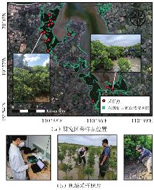
Fig. 1
Location of study area sampling points and on-site data collection"
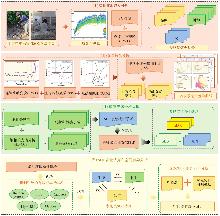
Fig. 2
Technical route"
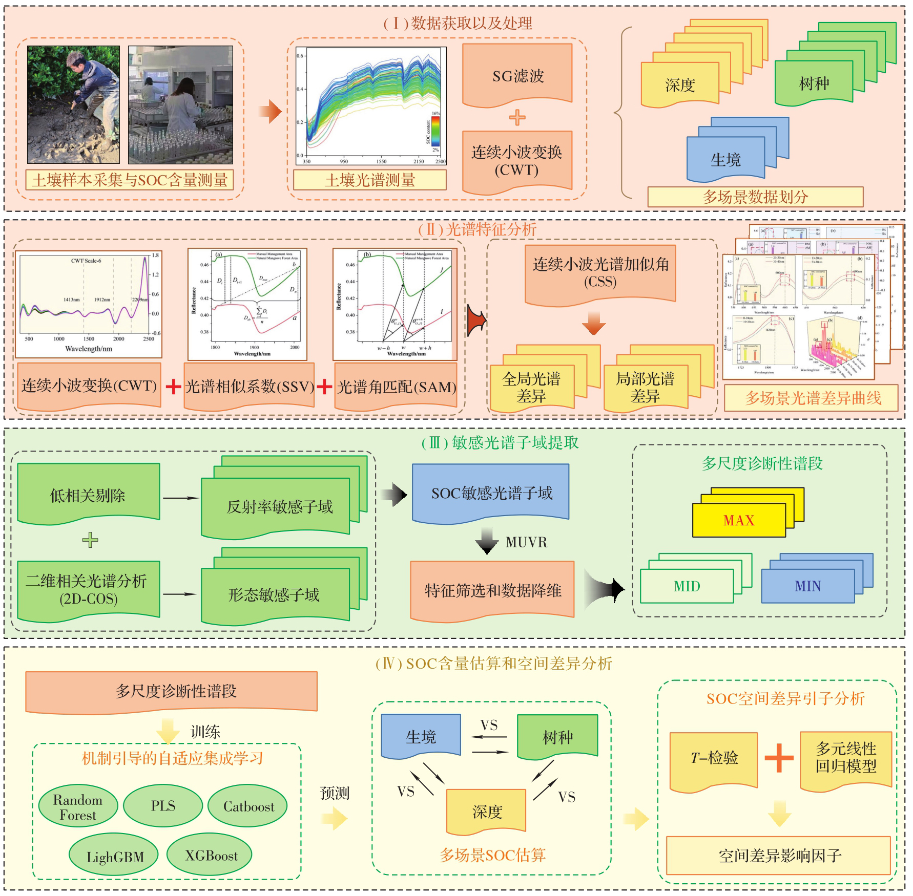
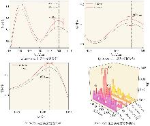
Fig. 3
SAM curves with different soil depths"
Fig. 4
SAM curves with different tree species"
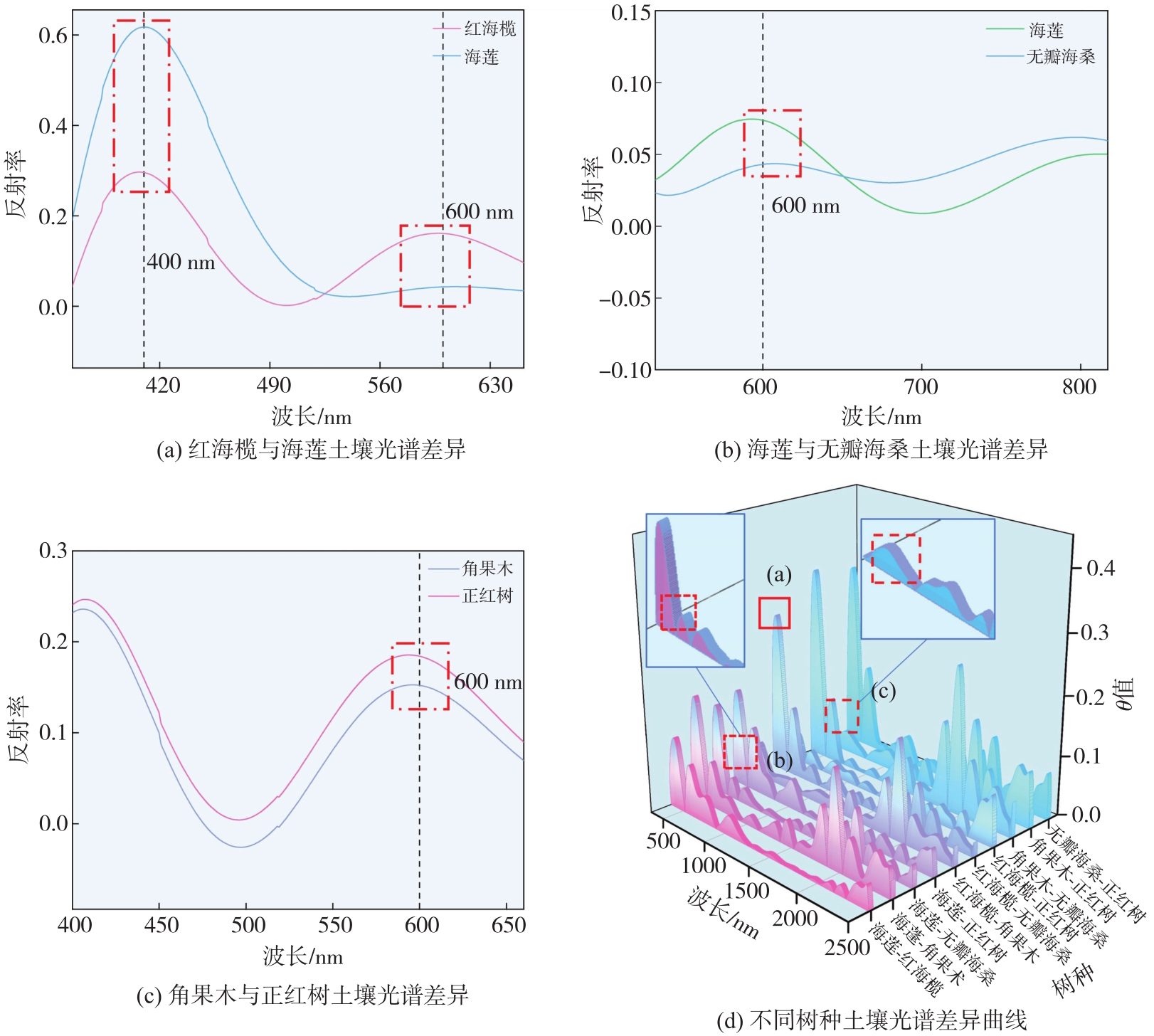
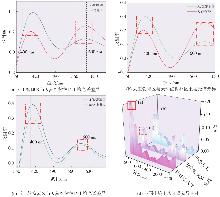
Fig. 5
SAM curves with different habitats"
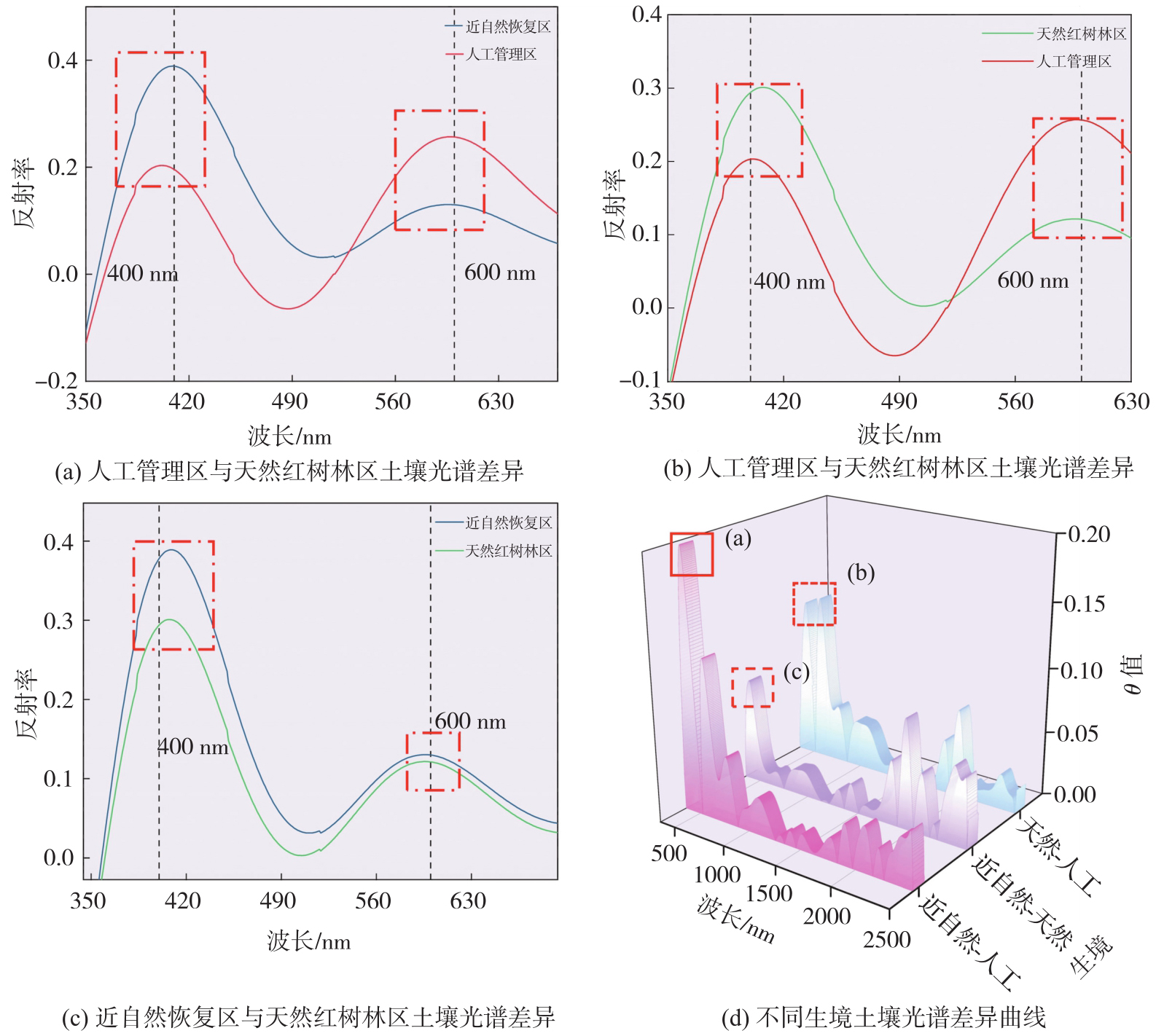
Fig. 6
SOC sensitive spectral subdomains and diagnostic spectral bands at different depths"
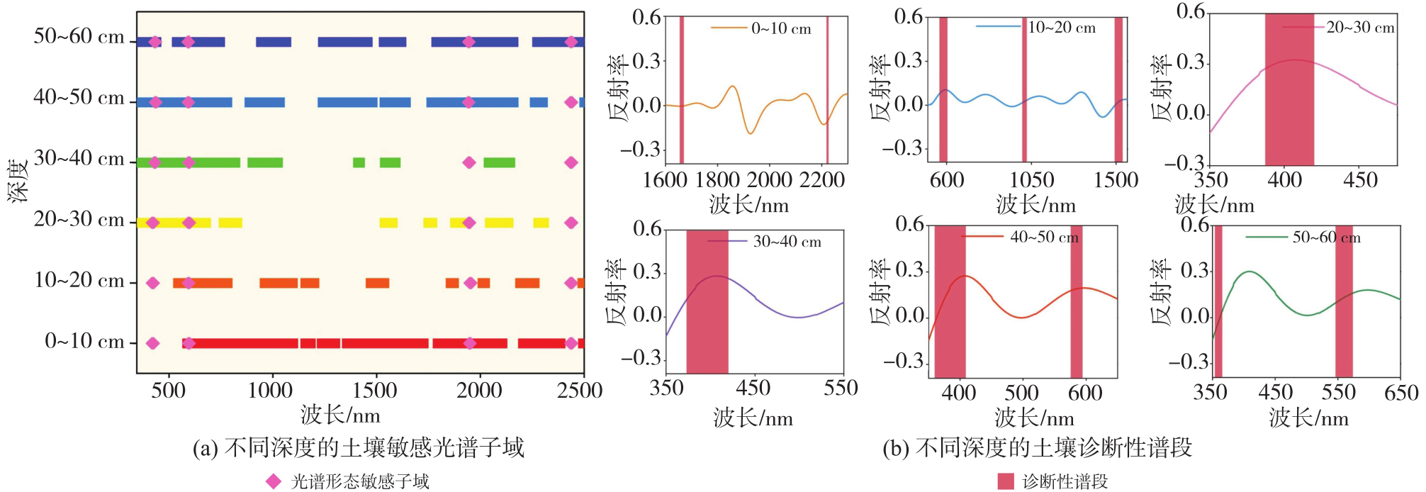
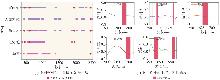
Fig. 7
SOC sensitive spectral subdomains and diagnostic spectral bands at different tree species"
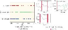
Fig. 8
SOC sensitive spectral subdomains and diagnostic spectral bands at different habitats"
Tab. 1
The inversion results of mangrove SOC under different soil depths"
| 深度/cm | 反演精度(R2) | 最优反演基模型 | ||||
|---|---|---|---|---|---|---|
| Max | Mid | Min | Max | Mid | Min | |
| 0~10 | 0.65 | 0.95 | 0.96 | AEL-PLS | AEL-XGBoost | AEL-RF |
| 10~20 | 0.60 | 0.55 | 0.46 | AEL-RF | AEL-PLS | AEL-PLS |
| 20~30 | 0.75 | 0.77 | 0.76 | AEL-PLS | AEL-PLS | AEL-PLS |
| 30~40 | 0.88 | 0.82 | 0.50 | AEL-RF | AEL-PLS | AEL-PLS |
| 40~50 | 0.82 | 0.63 | 0.57 | AEL-XGBoost | AEL-PLS | AEL-PLS |
| 50~60 | 0.90 | 0.79 | 0.71 | AEL-XGBoost | AEL-RF | AEL-XGBoost |
Tab. 2
The inversion results of mangroves SOC under different tree species"
| 树种 | 反演精度(R2) | 最优反演基模型 | ||||
|---|---|---|---|---|---|---|
| Max | Mid | Min | Max | Mid | Min | |
| 海莲 | 0.95 | 0.97 | 0.97 | PLS | PLS | PLS |
| 角果木 | 0.80 | 0.92 | 0.66 | AEL-PLS | AEL-XGBoost | AEL-RF |
| 红海榄 | 0.78 | 0.85 | 0.86 | AEL-RF | AEL-PLS | AEL-PLS |
| 正红树 | 0.98 | 0.96 | 0.99 | PLS | PLS | PLS |
| 无瓣海桑 | 0.96 | 0.95 | 0.94 | PLS | PLS | PLS |
Tab. 3
Inversion results of mangroves SOC under different habitats"
| 生境 | 反演精度(R2) | 最优反演基模型 | ||||
|---|---|---|---|---|---|---|
| Max | Mid | Min | Max | Mid | Min | |
| 天然红树林区 | 0.70 | 0.61 | 0.62 | AEL-LightGBM | AEL-PLS | AEL-RF |
| 近自然恢复区 | 0.85 | 0.62 | 0.76 | AEL-PLS | AEL-PLS | AEL-PLS |
| 人工管理区 | 0.71 | 0.73 | 0.78 | AEL-PLS | AEL-PLS | AEL-Catboost |
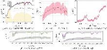
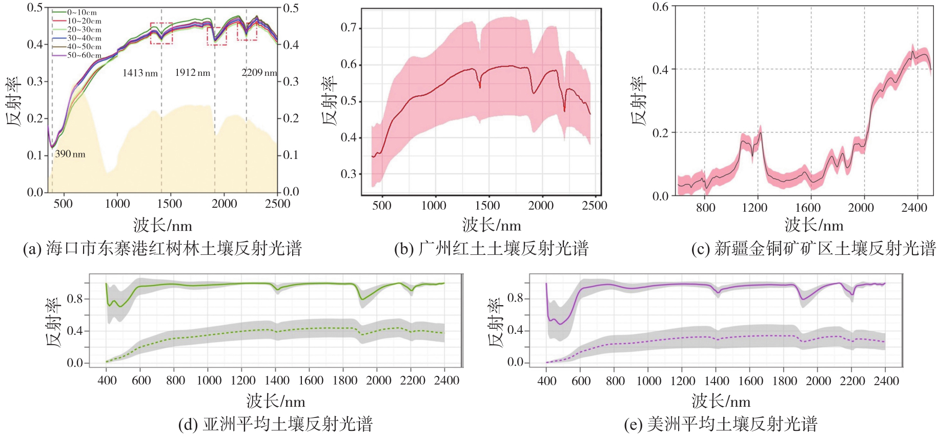
Fig. 9
Spectral curves with different types of soil"
| [1] | LOVELOCK C E, REEF R Variable impacts of climate change on blue carbon[J]. One Earth, 2020, 3(2): 195-211. |
| [2] | CEANTURI A, TUAHATU J W, LOKOLLO F F, et al. Mangrove ecosystems in southeast Asia region: mangrove extent, blue carbon potential and CO2 emissions in 1996—2020[J]. Science of the Total Environment, 2024(915): 170052. |
| [3] | SHARMA S, SUWA R, RAY R, et al. Preface: blue carbon studies in Asia-Pacific regions: current status, gaps, and future perspectives[J]. Ecological Research, 2022, 37(1): 5-8. |
| [4] | HUANG X, WANG X, LI X, et al. Distribution pattern and influencing factors for soil organic carbon (SOC) in mangrove communities at Dongzhaigang, China[J]. Journal of Coastal Research, 2018, 34(2): 434-442. |
| [5] | BARRETO M B, LO MÓNACO S, DÍAZ R, et al. Soil organic carbon of mangrove forests (Rhizophora and Avicennia) of the Venezuelan Caribbean coast[J]. Organic Geochemistry, 2016, 100: 51-61. |
| [6] | 马文婷, 高若. 蓝碳经济与海洋生态文明协同发展研究[J]. 江苏海洋大学学报(人文社会科学版), 2025, 23(3): 1-10. |
| MA Wenting, GAO Ruo. Research on the coordinated development of blue carbon economy and marine ecological civilization[J]. Journal of Jiangsu Ocean University (Humanities and Social Sciences Edition), 2025, 23(3): 1-10. | |
| [7] | 尹成卓, 高小红, 宋奇, 等. 基于Sentinel-2影像的农田土壤有机碳含量估算——以湟水流域典型区域为例[J]. 激光与光电子学进展, 2025, 62(12): 294-305. |
| YIN Chengzhuo, GAO Xiaohong, SONG, Qi, et al. Estimation of soil organic carbon content in farmland based on Sentinel-2 imagery: case study of a typical area in the Huangshui river basin[J]. Laser & Optoelectronics Progress, 2025, 62(12): 294-305. | |
| [8] | 曹霸, 凌成星. 基于GF-1遥感数据的若尔盖高寒沼泽湿地地上生物量与土壤有机碳密度估算[J]. 遥感技术与应用, 2021, 36(1): 229-236. |
| CAO Ba, LING Chengxing, Estimation of aboveground biomass and soil organic carbon density of Zoige Alpine wetland based on GF-1 remote sensing data[J]. Remote Sensing Technology and Application, 2021, 36(1): 229-236. | |
| [9] | HUANG C, GONG W, PANG Y. Remote sensing and forest carbon monitoring—a review of recent progress, challenges and opportunities[J]. Journal of Geodesy and Geoinformation Science, 2022, 5(2): 124. |
| [10] | 周涛, 史培军, 罗巾英, 等. 基于遥感与碳循环过程模型估算土壤有机碳储量[J]. 遥感学报, 2007(1): 127-136. |
| ZHOU Tao, SHI Peijun, LUO Jinying, et al. Estimation of soil organic carbon based on remote sensing and process model[J]. National Remote Sensing Bulletin, 2007(1): 127-136. | |
| [11] | CASTALDI F, HALIL K M, WETTERLIND J, et al. Assessing the capability of Sentinel-2 time-series to estimate soil organic carbon and clay content at local scale in croplands[J]. ISPRS Journal of Photogrammetry and Remote Sensing, 2023, 199: 40-60. |
| [12] | ŽÍŽALA D, MINAŘÍK R, ZÁDOŘOVÁ T. Soil organic carbon mapping using multispectral remote sensing data: prediction ability of data with different spatial and spectral resolutions[J]. Remote Sensing, 2019, 11(24): 2947. |
| [13] | 杨珺婷, 李晓松. 应用哨兵2号卫星遥感影像数据和机器学习算法对锡林郭勒草原土壤表层有机碳及全氮的估算[J]. 东北林业大学学报, 2022, 50(1): 64-71. |
| YANG Junting, LI Xiaosong. Estimation of topsoil organic carbon and total nitrogen in Xilin Gol grassland using Sentinel-2 and machine learning[J]. Journal of Northeast Forestry University, 2022, 50(1): 64-71. | |
| [14] | XU X, CHEN S, XU Z, et al. Exploring appropriate preprocessing techniques for hyperspectral soil organic matter content estimation in black soil area[J]. Remote Sensing, 2020, 12(22): 3765. |
| [15] | MENG X, BAO Y, LIU J, et al. Regional soil organic carbon prediction model based on a discrete wavelet analysis of hyperspectral satellite data[J]. International Journal of Applied Earth Observation and Geoinformation, 2020, 89: 102111. |
| [16] | XIAO B, LI S, DOU S, et al. Comparison of leaf Chlorophyll content retrieval performance of citrus using FOD and CWT methods with field-based full-spectrum hyperspectral reflectance data[J]. Computers and Electronics in Agriculture, 2024, 217: 108559. |
| [17] | HUANG X, WANG X, BAISHAN K, et al. Hyperspectral estimation of soil organic carbon content based on continuous wavelet transform and successive projection algorithm in arid area of Xinjiang, China[J]. Sustainability, 2023, 15(3): 2587. |
| [18] | XIA K, WU T, ZHANG S, et al. A new method for high-precision estimation of soil organic matter using two-dimensional correlation spectroscopy—to support collaborative use of global open soil spectral libraries[J]. Geoderma, 2024, 445: 116877. |
| [19] | LAUNER H F, TOMIMATSU Y. Rapid accurate determination of carbohydrates and other substances with dichromate heat-of-dilution method[J]. Analytical Chemistry, 1953, 25(11): 1767-1769. |
| [20] | SAVITZKY A, GOLAY M J E. Smoothing and differentiation of data by simplified least squares procedures[J]. Analytical Chemistry, 1964, 36(8): 1627-1639. |
| [21] | RIOUL O, DUHAMEL P. Fast algorithms for discrete and continuous wavelet transforms[J]. IEEE Transactions on Information Theory, 1992, 38(2): 569-586. |
| [22] | FU B, LIANG Y, LAO Z, et al. Quantifying scattering characteristics of mangrove species from Optuna-based optimal machine learning classification using multi-scale feature selection and SAR image time series[J]. International Journal of Applied Earth Observation and Geoinformation, 2023, 122: 103446. |
| [23] | SHEPHERD K D, FERGUSON R, HOOVER D, et al. A global soil spectral calibration library and estimation service[J]. Soil Security, 2022, 7: 100061. |
| [24] | WANG Z, CHEN S, LU R, et al. Non-linear memory-based learning for predicting soil properties using a regional vis-NIR spectral library[J]. Geoderma, 2024, 441: 116752. |
| [25] | ROWLEY M C, NICO P S, BONE S E, et al. Association between soil organic carbon and calcium in acidic grassland soils from Point Reyes National Seashore, CA[J]. Biogeochemistry, 2023, 165(1): 91-111. |
| [26] | WEI D L, BARET F, XING F G, et al. Relating soil surface moisture to reflectance[J]. Remote Sensing of Environment, 2002, 81(2): 238-246. |
| [27] | DING J, YANG A, WANG J, et al. Machine-learning-based quantitative estimation of soil organic carbon content by VIS/NIR spectroscopy[J]. PeerJ, 2018, 6: e5714. |
| [28] | DEMATTÊJ A M, TERRA F D S, QUARTAROLI C F. Spectral behavior of some modal soil profiles from S ã o Paulo State, Brazil[J]. Bragantia, 2012, 71(3): 413-423. |
| [1] | Peng LI, Jiahan ZHANG, Zhihan WANG, Houjie WANG, Zhenhong LI. A review of intertidal topography reconstruction methods: current status, challenges and trends [J]. Acta Geodaetica et Cartographica Sinica, 2026, 55(4): 571-587. |
| [2] | Lanxin WU, Jiangtao PENG, Weiwei SUN, Bing YANG. An Euler embedding and complementary feature modeling framework for hyperspectral change detection in coastal wetlands [J]. Acta Geodaetica et Cartographica Sinica, 2026, 55(4): 618-631. |
| [3] | Ertao GAO, Jing LIU, Shujin LI, Guoqing ZHOU, Bolin FU, Shuxian LI. Multi-dimensional spatiotemporal monitoring and analysis of tidal flats in the Maowei Sea using integrated optical remote sensing and SAR [J]. Acta Geodaetica et Cartographica Sinica, 2026, 55(4): 632-646. |
| [4] | Hao XU, Nan XU, Huichao XIN, Yue MA, Wei TU, Qingquan LI. A topographic photon extraction method for intertidal zones using ICESat-2 satellite altimeter data [J]. Acta Geodaetica et Cartographica Sinica, 2026, 55(4): 658-672. |
| [5] | Jinwei BU, Shuhui LIU, Shunshuang XU, Tongsu XIANG, Qiulan WANG, Chaoying JI, Xiaoqing ZUO. Construction of an empirical model for estimating the global wave period of spaceborne GNSS-R [J]. Acta Geodaetica et Cartographica Sinica, 2026, 55(4): 684-697. |
| [6] | Zexin YANG. Research on key technologies for reconstructing building models with multi-LODs using point clouds [J]. Acta Geodaetica et Cartographica Sinica, 2026, 55(4): 755-755. |
| [7] | Yongxiang YAO. Generalized similarity feature-based robust matching of multi-modal remote sensing images [J]. Acta Geodaetica et Cartographica Sinica, 2026, 55(4): 757-757. |
| [8] | Dong XU. Research on key technologies of global localization using multisource geo-referenced point cloud [J]. Acta Geodaetica et Cartographica Sinica, 2026, 55(4): 760-760. |
| [9] | Chenming YE, Zhizhong KANG, Jinhao CAI, Bingzheng ZUO, Shuai SHAO, Yan LI. A morphology-guided real-scene 3D modeling method of lunar geo-entities [J]. Acta Geodaetica et Cartographica Sinica, 2026, 55(3): 525-535. |
| [10] | Meilian WANG. Machine learning based methods for tree species classification and wood-leaf separation from handheld LiDAR data [J]. Acta Geodaetica et Cartographica Sinica, 2026, 55(3): 569-569. |
| [11] | Daifeng PENG, Xuelian LIU, Mengfei LU, Haiyan GUAN. Heterogeneous remote sensing image flood change detection based on multi-scale cross-modal feature fusion [J]. Acta Geodaetica et Cartographica Sinica, 2026, 55(2): 328-343. |
| [12] | Haopeng HU, Hangbin WU, Shihao ZHAN, Zaihao WEN, Chun LIU. Road pole-like object change detection supported by visual point cloud quality optimization [J]. Acta Geodaetica et Cartographica Sinica, 2026, 55(2): 344-358. |
| [13] | Donghang YU. Research on scene and object recognition in high resolution remote sensing images [J]. Acta Geodaetica et Cartographica Sinica, 2026, 55(2): 377-377. |
| [14] | Bin HAN, Xin HUANG, Fengyi LI, Xiaozhen LU. Water body segmentation network for SAR images combining dual-encoder and adaptive feature fuse [J]. Acta Geodaetica et Cartographica Sinica, 2026, 55(1): 101-113. |
| [15] | Yu DANG, Jianjun ZHU, Haiqiang FU, Haitao ZHAO, Haipeng CHEN. Anomaly detection method for small-sample optical remote sensing constrained by diffusion characteristics [J]. Acta Geodaetica et Cartographica Sinica, 2026, 55(1): 114-123. |
| Viewed | ||||||
|
Full text |
|
|||||
|
Abstract |
|
|||||