

Acta Geodaetica et Cartographica Sinica ›› 2026, Vol. 55 ›› Issue (1): 101-113.doi: 10.11947/j.AGCS.2026.20250303
• Photogrammetry and Remote Sensing • Previous Articles Next Articles
Bin HAN1( ), Xin HUANG1, Fengyi LI1, Xiaozhen LU2()
Received:2025-07-28
Revised:2026-01-04
Online:2026-02-13
Published:2026-02-13
Contact:
Xiaozhen LU
E-mail:njupt.bh@foxmail.com;luxiaozhen@nuaa.edu.cn
About author:HAN Bin (1990—), male, PhD, associate professor, majors in remote sensing image processing. E-mail: njupt.bh@foxmail.com
Supported by:CLC Number:
Bin HAN, Xin HUANG, Fengyi LI, Xiaozhen LU. Water body segmentation network for SAR images combining dual-encoder and adaptive feature fuse[J]. Acta Geodaetica et Cartographica Sinica, 2026, 55(1): 101-113.
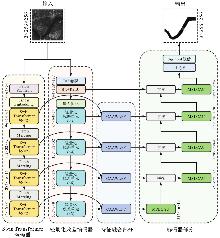
Fig. 1
Overall structure of DEAFFNet"

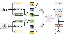
Fig. 2
Specific structure of CAAWLFF module"

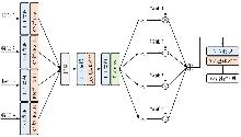
Fig. 3
Specific approach to AWLM-based hybrid feature fusion"
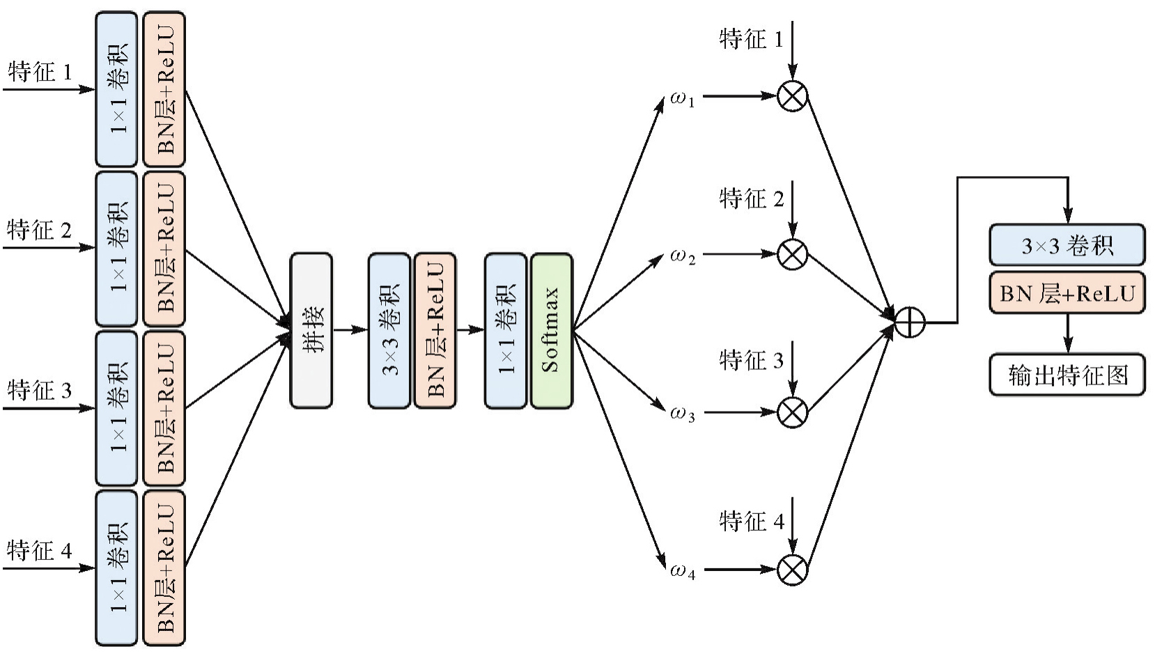
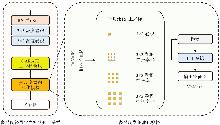
Fig. 4
Specific structure of MSLCAU module"

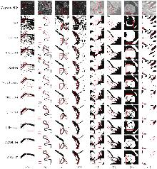
Fig. 5
Water body segmentation results on SAR images, including the original label and the outputs from eight different models"

Tab. 1
Comparison of performances of different methods on the ALOS PALSAR dataset"
| 模型 | 数据集 | IoU | mIoU | POA | Kappa |
|---|---|---|---|---|---|
| UNet | ALOS PALSAR | 89.81 | 71.19 | 93.45 | 68.89 |
| Sen1-SAR | 68.43 | 68.35 | 78.62 | 68.21 | |
| ResUNet | ALOS PALSAR | 91.37 | 72.37 | 94.07 | 71.76 |
| Sen1-SAR | 73.24 | 71.61 | 81.21 | 70.25 | |
| SwinUNet | ALOS PALSAR | 92.57 | 79.08 | 94.74 | 78.36 |
| Sen1-SAR | 76.78 | 77.13 | 83.25 | 76.45 | |
| WaterFormer | ALOS PALSAR | 93.42 | 74.29 | 94.64 | 72.01 |
| Sen1-SAR | 85.11 | 84.52 | 91.47 | 83.57 | |
| DSHNet | ALOS PALSAR | 93.82 | 83.28 | 94.97 | 85.22 |
| Sen1-SAR | 84.35 | 83.21 | 90.56 | 82.56 | |
| MAFUNet | ALOS PALSAR | 94.28 | 84.75 | 97.23 | 86.81 |
| Sen1-SAR | 91.28 | 86.43 | 92.32 | 84.98 | |
| LEFormer | ALOS PALSAR | 93.98 | 84.37 | 96.43 | 85.92 |
| Sen1-SAR | 90.76 | 85.45 | 91.47 | 84.54 | |
| QTU-Net | ALOS PALSAR | 94.13 | 85.02 | 96.91 | 86.43 |
| Sen1-SAR | 90.97 | 86.21 | 91.83 | 84.72 | |
| DEAFFNet | ALOS PALSAR | 95.67 | 86.17 | 97.89 | 89.96 |
| Sen1-SAR | 92.26 | 88.71 | 93.67 | 87.09 |
Tab. 2
Ablation experimental results of different modules of the model"
| 模块 | IoU | mIoU | POA | Kappa |
|---|---|---|---|---|
| 基线 | 90.16 | 71.89 | 93.82 | 71.28 |
| 双编码器 | 92.37 | 77.38 | 94.38 | 76.97 |
| 双编码器+CAAWLFF | 94.11 | 82.85 | 97.18 | 85.92 |
| 双编码器+MSLCAU | 93.27 | 81.79 | 96.54 | 83.38 |
| DEAFFNet | 95.67 | 86.17 | 97.89 | 89.96 |
Tab. 3
Comparison of performances under different loss functions"
| 函数 | IoU | mIoU | POA | Kappa |
|---|---|---|---|---|
| Baseline+BCE | 89.64 | 71.12 | 92.97 | 68.71 |
| Baseline+Focal | 90.02 | 71.64 | 93.54 | 70.82 |
| Baseline+Focal+AC | 90.16 | 71.89 | 93.82 | 71.28 |
| DEAFFNet+BCE | 94.98 | 84.81 | 97.31 | 86.89 |
| DEAFFNet+Focal | 95.32 | 85.19 | 97.58 | 87.11 |
| DEAFFNet+Focal+AC | 95.67 | 86.17 | 97.89 | 89.96 |
| [1] |
刘帅, 李笑迎, 于梦, 等. 高分辨率遥感图像双解耦语义分割网络模型[J]. 测绘学报, 2023, 52(4): 638-647. DOI: .
doi: 10.11947/j.AGCS.2023.20210455 |
|
LIU Shuai, LI Xiaoying, YU Meng, et al. Dual decoupling semantic segmentation model for high-resolution remote sensing images[J]. Acta Geodaetica et Cartographica Sinica, 2023, 52(4): 638-647. DOI: .
doi: 10.11947/j.AGCS.2023.20210455 |
|
| [2] |
董子博, 王竞雪, 卜丽静, 等. MAFNet:基于多尺度空洞融合网络的遥感影像建筑物提取方法[J]. 测绘学报, 2025, 54(6): 1094-1106. DOI: .
doi: 10.11947/j.AGCS.2025.20240439 |
|
DONG Zibo, WANG Jingxue, BU Lijing, et al. MAFNet: building extraction method from remote sensing images based on multi-scale atrous fusion network[J]. Acta Geodaetica et Cartographica Sinica, 2025, 54(6): 1094-1106. DOI: .
doi: 10.11947/j.AGCS.2025.20240439 |
|
| [3] | PULVIRENTI L, PIERDICCA N, CHINI M, et al. An algorithm for operational flood mapping from synthetic aperture radar (SAR) data using fuzzy logic[J]. Natural Hazards and Earth System Sciences, 2011, 11(2): 529-540. |
| [4] | QIN Xingli, YANG Jie, LI Pingxiang, et al. Research on water body extraction from Gaofen-3 imagery based on polarimetric decomposition and machine learning[C]//Proceedings of 2019 IEEE International Geoscience and Remote Sensing Symposium. Yokohama: IEEE, 2019: 6903-6906. |
| [5] | GASNIER N, DENIS L, FJØRTOFT R, et al. Narrow river extraction from SAR images using exogenous information[J]. IEEE Journal of Selected Topics in Applied Earth Observations and Remote Sensing, 2021, 14: 5720-5734. |
| [6] | ZHANG Tianyi, JI Wenbo, LI Weibin, et al. EDWNet: a novel encoder-decoder architecture network for water body extraction from optical images[J]. Remote Sensing, 2024, 16(22): 4275. |
| [7] | WANG Jing, JIA Dongmei, XUE Jiaxing, et al. Automatic water body extraction from SAR images based on MADF-Net[J]. Remote Sensing, 2024, 16(18): 3419. |
| [8] | WENG Zhi, LI Qiyan, ZHENG Zhiqiang, et al. SCR-Net: a dual-channel water body extraction model based on multi-spectral remote sensing imagery: a case study of Daihai Lake, China[J]. Sensors, 2025, 25(3): 763. |
| [9] | YUAN Da, WANG Chao, WU Lin, et al. Water stream extraction via feature-fused encoder-decoder network based on SAR images[J]. Remote Sensing, 2023, 15(6): 1559. |
| [10] | NI Hao, LI Jianfeng, WANG Chenxu, et al. SDNet: sandwich decoder network for waterbody segmentation in remote sensing imagery[J]. IEEE Journal of Selected Topics in Applied Earth Observations and Remote Sensing, 2025, 18: 13895-13911. |
| [11] | WANG Jingming, WANG Shixin, WANG Futao, et al. FWENet: a deep convolutional neural network for flood water body extraction based on SAR images[J]. International Journal of Digital Earth, 2022, 15(1): 345-361. |
| [12] | WANG Zhen, YOU Zhuhong, XU Nan, et al. UAVSeg: dual-encoder cross-scale attention network for UAV images'semantic segmentation[J]. IEEE Transactions on Geoscience and Remote Sensing, 2025, 63: 5600117. |
| [13] | YU Mouzhe, HE Liheng, SHEN Zhehui, et al. STRD-net: a dual-encoder semantic segmentation network for urban green space extraction[J]. IEEE Transactions on Geoscience and Remote Sensing, 2024, 62: 4413913. |
| [14] | LIU Ye, SONG Shitao, WANG Miaohui, et al. DE-Unet: dual-encoder U-Net for ultra-high resolution remote sensing image segmentation[J]. IEEE Journal of Selected Topics in Applied Earth Observations and Remote Sensing, 2025, 18: 12290-12302. |
| [15] | FU Yujia, ZHANG Xiangrong, WANG Mingyang. DSHNet: a semantic segmentation model of remote sensing images based on dual stream hybrid network[J]. IEEE Journal of Selected Topics in Applied Earth Observations and Remote Sensing, 2024, 17: 4164-4175. |
| [16] | KANG Jian, GUAN Haiyan, MA Lingfei, et al. WaterFormer: a coupled transformer and CNN network for waterbody detection in optical remotely-sensed imagery[J]. ISPRS Journal of Photogrammetry and Remote Sensing, 2023, 206: 222-241. |
| [17] | LI Y, ZHANG Y, WANG Z, et al. LEFormer: Lake extraction from remote sensing imagery using a dual-encoder transformer network[C]//Proceedings of 2023 IEEE/CVF International Conference on Computer Vision. VANCOUVER: IEEE, 2023: 10693-10702. |
| [18] | LI Yansheng, CHEN Wei, HUANG Xin, et al. MFVNet: a deep adaptive fusion network with multiple field-of-views for remote sensing image semantic segmentation[J]. Science China Information Sciences, 2023, 66(4): 140305. |
| [19] | WU Kang, ZHANG Yingying, RU Lixiang, et al. A semantic-enhanced multi-modal remote sensing foundation model for Earth observation[J]. Nature Machine Intelligence, 2025, 7(8): 1235-1249. |
| [20] | HE Kaiming, ZHANG Xiangyu, REN Shaoqing, et al. Deep residual learning for image recognition[C]//Proceedings of 2016 IEEE Conference on Computer Vision and Pattern Recognition. Las Vegas: IEEE, 2016: 770-778. |
| [21] | LIU Ze, LIN Yutong, CAO Yue, et al. Swin Transformer: hierarchical vision transformer using shifted windows[C]//Proceedings of 2021 IEEE/CVF International Conference on Computer Vision. Montreal: IEEE, 2022: 9992-10002. |
| [22] | CHEN C R, FAN Quanfu, PANDA R. CrossViT: cross-attention multi-scale vision transformer for image classification[C]//Proceedings of 2021 IEEE/CVF International Conference on Computer Vision. Montreal: IEEE, 2022: 347-356. |
| [23] | WANG Jiaqi, CHEN Kai, XU Rui, et al. CARAFE: content-aware reassembly of features[C]//Proceedings of 2019 IEEE/CVF International Conference on Computer Vision. Seoul: IEEE, 2019: 3007-3016. |
| [24] | LIN T Y, GOYAL P, GIRSHICK R, et al. Focal loss for dense object detection[C]//Proceedings of 2017 IEEE International Conference on Computer Vision. Venice: IEEE, 2017: 2999-3007. |
| [25] | PHAM V T, TRAN T T, WANG Pachun, et al. Tympanic membrane segmentation in otoscopic images based on fully convolutional network with active contour loss[J]. Signal, Image and Video Processing, 2021, 15(3): 519-527. |
| [26] | GU Jia, FANG Zhijun, GAO Yongbin, et al. Segmentation of coronary arteries images using global feature embedded network with active contour loss[J]. Computerized Medical Imaging and Graphics, 2020, 86: 101799. |
| [27] | CHICCHON M, COLOSI F, MALINVERNI E S, et al. Urban sprawl monitoring by VHR images using active contour loss and improved U-Net with mix transformer encoders[J]. Remote Sensing, 2025, 17(9): 1593. |
| [28] | CHEN Bo, JI Jing, LI Junwei, et al. An adaptive weighted active contour based HRNet for underwater image segmentation[J]. Pattern Recognition, 2026, 172: 112368. |
| [29] | CHICCHON M, TRUJILLO F J L, SIPIRAN I, et al. Land-cover semantic segmentation for very-high-resolution remote sensing imagery using deep transfer learning and active contour loss[J]. IEEE Access, 2025, 13: 59007-59019. |
| [30] | DIAKOGIANNIS F I, WALDNER F, CACCETTA P, et al. ResUNet-a: a deep learning framework for semantic segmentation of remotely sensed data[J]. ISPRS Journal of Photogrammetry and Remote Sensing, 2020, 162: 94-114. |
| [31] | CAO Hu, WANG Yueyue, CHEN J, et al. Swin-unet: unet-like pure transformer for medical image segmentation[EB/OL]. [2025-10-05]. https://arxiv.org/abs/2105.05537. |
| [32] |
邢广澳, 卢官明, 韩斌. MAFUNet:结合注意力机制和主动轮廓损失的SAR图像水体分割算法[J]. 测绘学报, 2025, 54(5): 924-936. DOI: .
doi: 10.11947/j.AGCS.2025.20240235 |
|
XING Guang'ao, LU Guanming, HAN Bin. MAFUNet: water body segmentation algorithm for SAR images combining attention mechanisms and active contour loss[J]. Acta Geodaetica et Cartographica Sinica, 2025, 54(5): 924-936. DOI: .
doi: 10.11947/j.AGCS.2025.20240235 |
|
| [33] | WANG Mingzhi, LI Chunshan, YANG Xiaofei, et al. QTU-Net: quaternion transformer-based U-Net for water body extraction of RGB satellite image[J]. IEEE Transactions on Geoscience and Remote Sensing, 2024, 62: 5634816. |
| [1] | Peng LI, Jiahan ZHANG, Zhihan WANG, Houjie WANG, Zhenhong LI. A review of intertidal topography reconstruction methods: current status, challenges and trends [J]. Acta Geodaetica et Cartographica Sinica, 2026, 55(4): 571-587. |
| [2] | bolin FU, Keyue HUANG, Yanli YANG, Weiwei SUN, Zhaoyin WANG. Multi-scene analysis of mangrove soil spectral response characteristics and inversion of soil organic carbon content based on measured full-spectrum hyperspectral data [J]. Acta Geodaetica et Cartographica Sinica, 2026, 55(4): 604-617. |
| [3] | Lanxin WU, Jiangtao PENG, Weiwei SUN, Bing YANG. An Euler embedding and complementary feature modeling framework for hyperspectral change detection in coastal wetlands [J]. Acta Geodaetica et Cartographica Sinica, 2026, 55(4): 618-631. |
| [4] | Ertao GAO, Jing LIU, Shujin LI, Guoqing ZHOU, Bolin FU, Shuxian LI. Multi-dimensional spatiotemporal monitoring and analysis of tidal flats in the Maowei Sea using integrated optical remote sensing and SAR [J]. Acta Geodaetica et Cartographica Sinica, 2026, 55(4): 632-646. |
| [5] | Hao XU, Nan XU, Huichao XIN, Yue MA, Wei TU, Qingquan LI. A topographic photon extraction method for intertidal zones using ICESat-2 satellite altimeter data [J]. Acta Geodaetica et Cartographica Sinica, 2026, 55(4): 658-672. |
| [6] | Jinwei BU, Shuhui LIU, Shunshuang XU, Tongsu XIANG, Qiulan WANG, Chaoying JI, Xiaoqing ZUO. Construction of an empirical model for estimating the global wave period of spaceborne GNSS-R [J]. Acta Geodaetica et Cartographica Sinica, 2026, 55(4): 684-697. |
| [7] | Zexin YANG. Research on key technologies for reconstructing building models with multi-LODs using point clouds [J]. Acta Geodaetica et Cartographica Sinica, 2026, 55(4): 755-755. |
| [8] | Yongxiang YAO. Generalized similarity feature-based robust matching of multi-modal remote sensing images [J]. Acta Geodaetica et Cartographica Sinica, 2026, 55(4): 757-757. |
| [9] | Dong XU. Research on key technologies of global localization using multisource geo-referenced point cloud [J]. Acta Geodaetica et Cartographica Sinica, 2026, 55(4): 760-760. |
| [10] | Chenming YE, Zhizhong KANG, Jinhao CAI, Bingzheng ZUO, Shuai SHAO, Yan LI. A morphology-guided real-scene 3D modeling method of lunar geo-entities [J]. Acta Geodaetica et Cartographica Sinica, 2026, 55(3): 525-535. |
| [11] | Meilian WANG. Machine learning based methods for tree species classification and wood-leaf separation from handheld LiDAR data [J]. Acta Geodaetica et Cartographica Sinica, 2026, 55(3): 569-569. |
| [12] | Daifeng PENG, Xuelian LIU, Mengfei LU, Haiyan GUAN. Heterogeneous remote sensing image flood change detection based on multi-scale cross-modal feature fusion [J]. Acta Geodaetica et Cartographica Sinica, 2026, 55(2): 328-343. |
| [13] | Haopeng HU, Hangbin WU, Shihao ZHAN, Zaihao WEN, Chun LIU. Road pole-like object change detection supported by visual point cloud quality optimization [J]. Acta Geodaetica et Cartographica Sinica, 2026, 55(2): 344-358. |
| [14] | Donghang YU. Research on scene and object recognition in high resolution remote sensing images [J]. Acta Geodaetica et Cartographica Sinica, 2026, 55(2): 377-377. |
| [15] | Yu DANG, Jianjun ZHU, Haiqiang FU, Haitao ZHAO, Haipeng CHEN. Anomaly detection method for small-sample optical remote sensing constrained by diffusion characteristics [J]. Acta Geodaetica et Cartographica Sinica, 2026, 55(1): 114-123. |
| Viewed | ||||||
|
Full text |
|
|||||
|
Abstract |
|
|||||