

Acta Geodaetica et Cartographica Sinica ›› 2025, Vol. 54 ›› Issue (11): 2009-2025.doi: 10.11947/j.AGCS.2025.20250199
• Photogrammetry and Remote Sensing • Previous Articles Next Articles
Xi GONG1,2( ), Zhanlong CHEN3,4,5, Hengqiang ZHENG1, Sheng HU6(), Hongyan ZHANG3
Received:2025-05-09
Revised:2025-09-27
Online:2025-12-15
Published:2025-12-15
Contact:
Sheng HU
E-mail:gongxi@hue.edu.cn;husheng@m.scnu.edu.cn
About author:GONG Xi (1992—), female, PhD, lecturer, majors in remote sensing and spatial data analysis. E-mail: gongxi@hue.edu.cn
Supported by:CLC Number:
Xi GONG, Zhanlong CHEN, Hengqiang ZHENG, Sheng HU, Hongyan ZHANG. Remote sensing image scene classification method integrating spatial and semantic information of transferred features[J]. Acta Geodaetica et Cartographica Sinica, 2025, 54(11): 2009-2025.
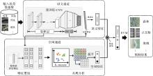
Fig. 1
Flowchart of the proposed method"

Tab. 1
Structure of convolutional layers in VGG-19"
| 组别 | 卷积层数目 | 特征尺寸 |
|---|---|---|
| conv1 | 2 | 64×224×224 |
| conv2 | 2 | 128×112×112 |
| conv3 | 4 | 256×56×56 |
| conv4 | 4 | 512×28×28 |
| conv5 | 4 | 512×14×14 |
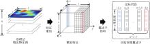
Fig. 2
Extraction of the initial descriptors"
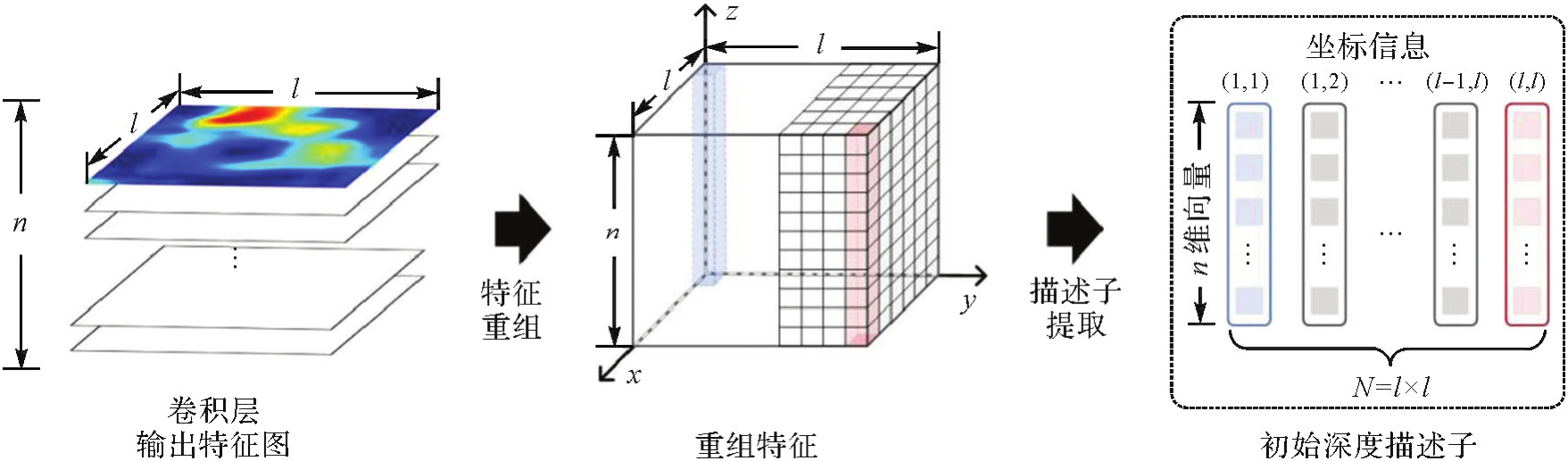
Fig. 3
Statistics of matching pairs of local deep descriptors that satisfy spatial distance constraints"
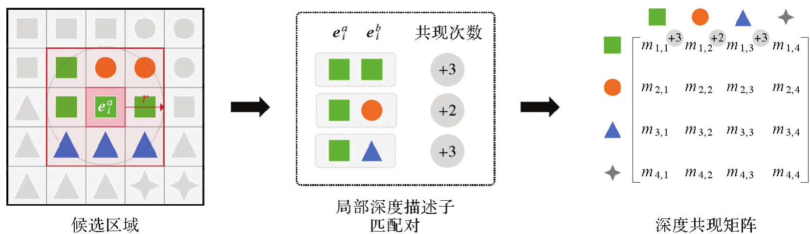
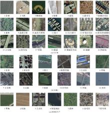
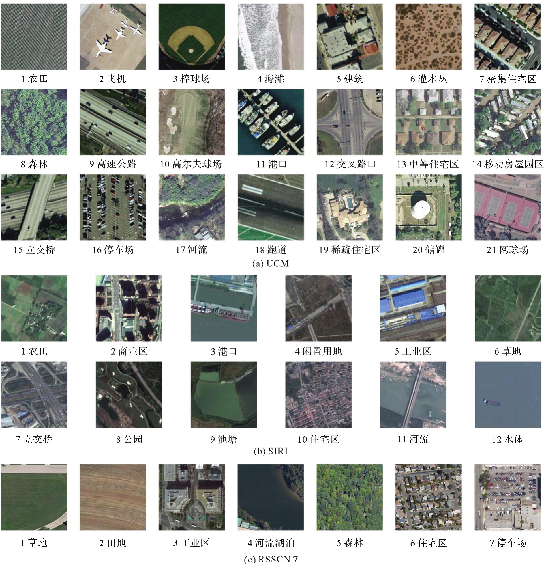
Fig. 4
Experimental remote sensing image scene datasets"
Tab. 2
Parameter information of experimental datasets"
| 数据集 | 场景尺寸 | 场景数目 | 训练样本占比/(%) |
|---|---|---|---|
| UCM | 256像素×256像素 | 2100 | 80 |
| SIRI | 200像素×200像素 | 2400 | 80 |
| RSSCN7 | 400像素×400像素 | 2800 | 50 |
Tab. 3
Experimental parameter information of spatial feature"
| 卷积层 | r值 | K值 |
|---|---|---|
| conv4:conv4_1、conv4_2、conv4_3、conv4_4 | 2、4、6、8、10、12、14 | UCM:50、200、400、600、800、1000、1200、1400、1600、1800、2000 |
| conv5:conv5_1、conv5_2、conv5_3、conv5_4 | 1、2、3、4、5、6、7 | SIRI:50、100、200、300、400、500、600、700、800、900、1000 |
Fig. 5
Classification results of spatial features with different parameters on UCM dataset"

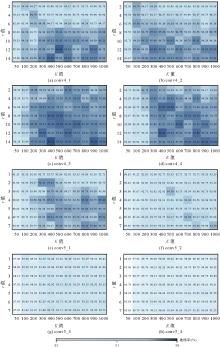
Fig. 6
Classification results of spatial features with different parameters on SIRI dataset"

Tab. 4
Classification results of spatial features and classical features"
| 分类特征 | 准确率 | |
|---|---|---|
| UCM | SIRI | |
| 方向梯度直方图特征 | 52.14 | 44.79 |
| 尺度不变特征变换特征 | 58.33 | 53.96 |
| 局部二值模式特征 | 31.43 | 46.25 |
| SIFT+BoVW | 76.81 | 75.63 |
| VGG-19卷积层级联深度特征[ | 93.33 | 93.48 |
| 空间特征的Min-acc | 84.01 | 84.79 |
| 空间特征的Mid-acc | 95.47 | 94.38 |
| 空间特征的Max-acc | 98.33 | 96.25 |
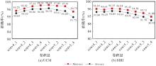
Fig. 7
Accuracy comparison of spatial features derived from different convolutional features"

Tab. 5
Settings of K value ranges"
| 数据集 | Low_K | Mid_K | High_K |
|---|---|---|---|
| UCM | {400,600,800} | {1000,1200,1400} | {1600,1800,2000} |
| SIRI | {200,300,400} | {500,600,700} | {800,900,1000} |
Tab. 6
Average accuracy comparison of spatial features with different K values on UCM dataset"
| 卷积层 | r值 | 不同K值下的平均准确率/(%) | ||
|---|---|---|---|---|
| Low_K | Mid_K | High_K | ||
| conv4 | 2 | 95.25 | 95.57 | 95.39 |
| 4 | 95.65 | 95.84 | 95.70 | |
| 6 | 96.05 | 96.15 | 96.13 | |
| 8 | 96.08 | 96.39 | 96.47 | |
| 10 | 96.37 | 96.69 | 96.47 | |
| 12 | 96.63 | 96.74 | 96.66 | |
| 14 | 96.66 | 96.76 | 96.84 | |
| 均值 | 96.10 | 96.31 | 96.24 | |
| conv5 | 1 | 94.94 | 95.36 | 94.62 |
| 2 | 95.58 | 96.00 | 95.60 | |
| 3 | 95.56 | 96.50 | 96.08 | |
| 4 | 96.12 | 96.95 | 96.58 | |
| 5 | 96.28 | 97.48 | 97.22 | |
| 6 | 96.48 | 97.37 | 97.19 | |
| 7 | 96.38 | 97.27 | 97.19 | |
| 均值 | 95.91 | 96.70 | 96.35 | |
Tab. 7
Average accuracy comparison of spatial features with different K values on SIRI dataset"
| 卷积层 | r值 | 不同K值下的平均准确率/(%) | ||
|---|---|---|---|---|
| Low_K | Mid_K | High_K | ||
| conv4 | 2 | 94.41 | 94.29 | 94.22 |
| 4 | 94.48 | 94.55 | 94.44 | |
| 6 | 94.86 | 94.72 | 94.62 | |
| 8 | 94.91 | 95.09 | 94.88 | |
| 10 | 94.97 | 95.30 | 95.09 | |
| 12 | 95.00 | 95.30 | 95.24 | |
| 14 | 95.19 | 95.28 | 95.43 | |
| 均值 | 94.83 | 94.93 | 94.85 | |
| conv5 | 1 | 92.95 | 93.13 | 93.09 |
| 2 | 93.46 | 93.44 | 93.65 | |
| 3 | 93.31 | 94.17 | 94.13 | |
| 4 | 93.49 | 94.41 | 94.44 | |
| 5 | 93.15 | 94.34 | 94.31 | |
| 6 | 93.49 | 94.48 | 94.41 | |
| 7 | 93.46 | 94.31 | 94.65 | |
| 均值 | 93.33 | 94.04 | 94.10 | |
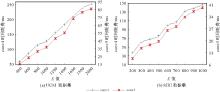
Fig. 8
Clustering time consumption at different K values"
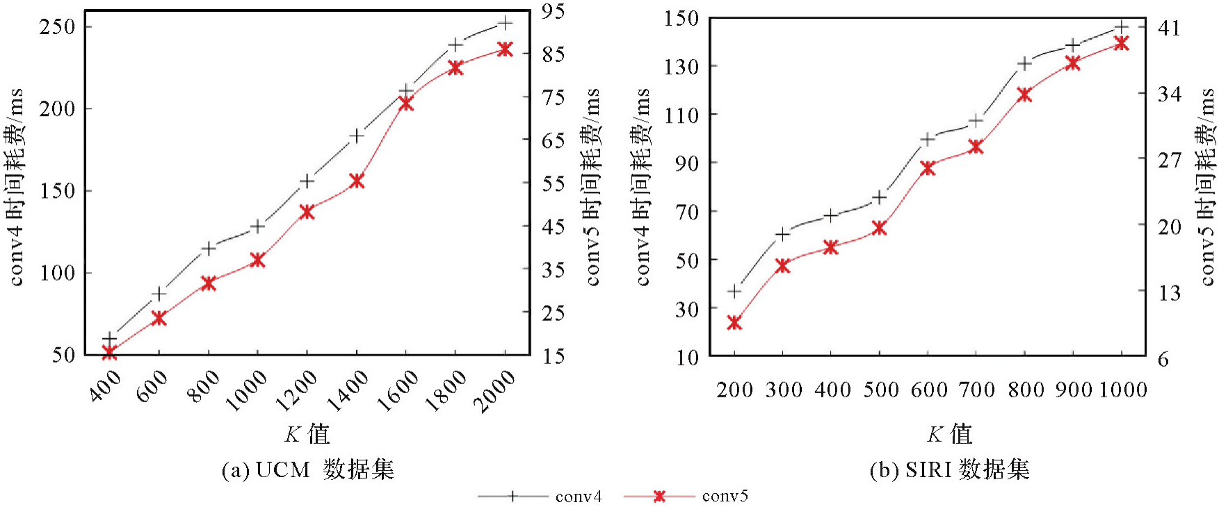
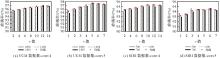
Fig. 9
Accuracy of spatial features with different r values on UCM and SIRI datasets"

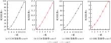
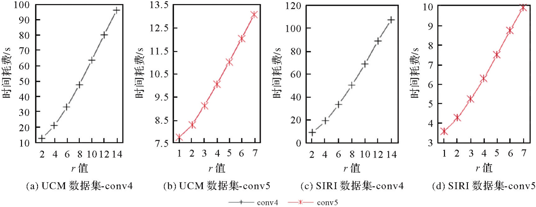
Fig. 10
Time consumption of deep spatial co-occurrence matrix calculation at different r values"
Tab. 8
Performance comparison of semantic features, spatial features and fusion features"
| 特征 | 准确率 | ||
|---|---|---|---|
| UCM | SIRI | RSSCN7 | |
| 语义特征G | 95.00 | 93.75 | 86.35 |
| 空间特征F | 98.33 | 96.25 | 92.78 |
| 联合特征z | 98.81 | 97.08 | 93.71 |
Tab. 9
Classification results on UCM dataset"
| 方法 | 准确率 |
|---|---|
| RF[ | 44.77 |
| SIFT+BoVW[ | 76.81 |
| SIFT+SPCK[ | 77.38 |
| VGG-19(从头训练) | 83.48 |
| JMCNN[ | 89.30 |
| 预训练VGG-19特征+SVM | 94.29 |
| GLDFB[ | 97.62 |
| TLMoE-VGG19[ | 98.10 |
| 本文方法 | 98.81 |
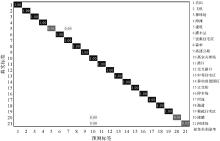
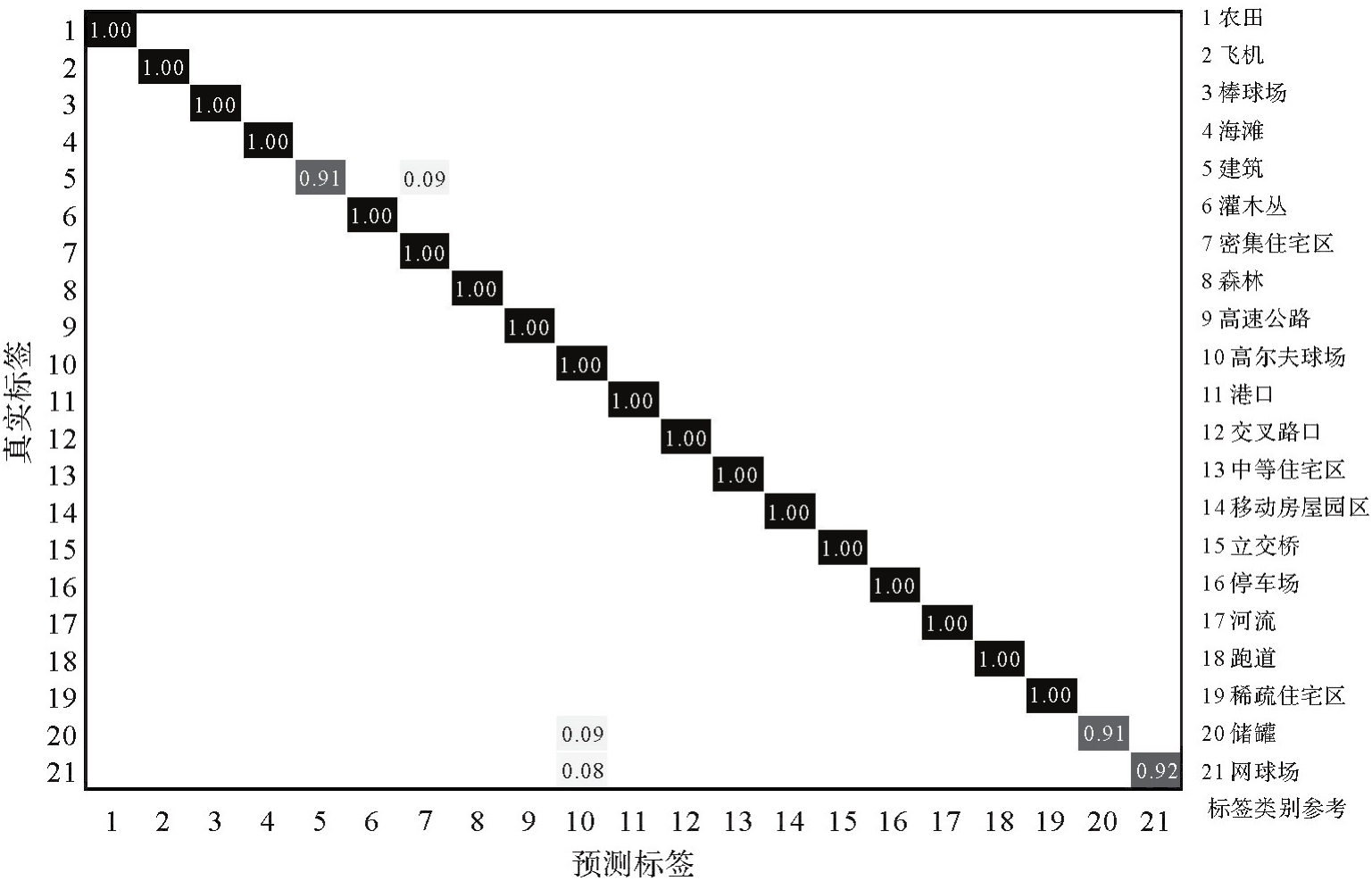
Fig. 11
Confusion matrix on UCM dataset"
Tab. 10
Classification results on SIRI dataset"
| 方法 | 准确率 |
|---|---|
| RF[ | 49.90 |
| SIFT+BoVW[ | 75.63 |
| SIFT+SPMK[ | 77.69±1.01 |
| VGG-19(从头训练) | 86.13 |
| 预训练VGG-19特征+SVM | 94.79 |
| GLDFB[ | 96.67 |
| ADC-CPANet[ | 96.04 |
| LAG-MANet[ | 97.04 |
| 本文方法 | 97.08 |
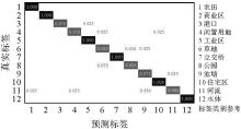
Fig. 12
Confusion matrix on SIRI dataset"
Tab. 11
Classification results on the RSSCN7 dataset"
| 方法 | 准确率 |
|---|---|
| RF[ | 55.43 |
| VGG-19(从头训练) | 82.50 |
| MECo-2-2[ | 86.67 |
| bank[ | 90.04±0.60 |
| 预训练VGG-19特征+SVM | 91.93 |
| TLMoE-VGG19[ | 93.21 |
| Dual Attention-Aware Network[ | 93.25±0.28 |
| 本文方法 | 93.71 |
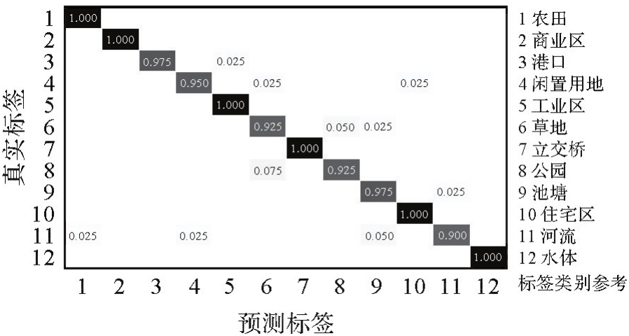
Fig. 13
Confusion matrix on RSSCN7 dataset"
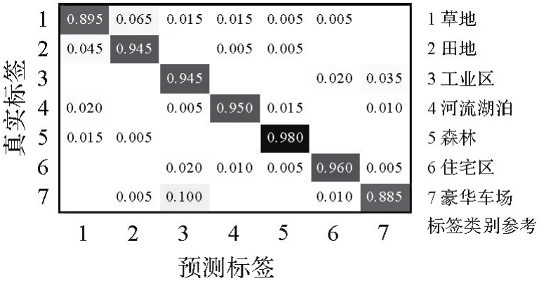
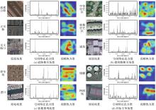
Fig. 14
Visualization of spatial features and spatial co-occurrence relationship contribution heatmap for different scenes"

Tab. 12
Classification results of the proposed method with other pre-trained CNNs on UCM dataset"
| 预训练网络 | 空间特征提取层 | 准确率 | ||
|---|---|---|---|---|
| 语义特征 | 空间特征 | 联合特征 | ||
| Alexnet[ | conv4 | 93.33 | 95.48 | 97.14 |
| Goog LeNet[ | inception4d | 93.81 | 96.67 | 97.38 |
| VGG16[ | conv4_2 | 95.47 | 97.14 | 97.62 |
| Resnet18[ | Res3a | 96.19 | 96.91 | 98.09 |
| Resnet50[ | Res3a | 96.91 | 97.85 | 98.33 |
| Resnet101[ | Res3a | 96.66 | 97.14 | 98.09 |
| DenseNet[ | denseblock3 | 97.62 | 97.85 | 98.57 |
| ShuffleNet[ | stage4 | 96.17 | 96.43 | 97.62 |
Tab. 13
Classification results of the proposed method with different pre-trained models on NWPU-RESISC45 dataset"
| 预训练模型 | 训练集占比10% | 训练集占比20% | ||
|---|---|---|---|---|
| 原始模型准确率 | 本文方法准确率 | 原始模型准确率 | 本文方法准确率 | |
| Alexnet[ | 81.98 | 82.64 | 85.73 | 86.48 |
| VGG16[ | 87.20 | 88.15 | 90.12 | 91.20 |
| VGG19[ | 87.53 | 88.33 | 90.75 | 91.46 |
| Resnet50[ | 89.78 | 90.55 | 92.41 | 92.72 |
| DenseNet[ | 90.17 | 90.46 | 92.32 | 92.75 |
| ShuffleNet[ | 84.23 | 85.25 | 88.70 | 89.04 |
| JMCNN[ | 56.44 | 57.02 | 65.57 | 66.44 |
| MF2CNet[ | 92.07 | 92.60 | 93.85 | 93.99 |
| EMTCAL[ | 91.63 | 92.51 | 93.65 | 94.35 |
| [1] | ROWLEY J. The wisdom hierarchy: representations of the DIKW hierarchy[J]. Journal of Information Science, 2007, 33(2): 163-180. |
| [2] | 郑卓, 方芳, 刘袁缘, 等. 高分辨率遥感影像场景的多尺度神经网络分类法[J]. 测绘学报, 2018, 47(5): 620-630. DOI: 10.11947/j.AGCS.2018.20170191. |
| ZHENG Zhuo, FANG Fang, LIU Yuanyuan, et al. Joint multi-scale convolution neural network for scene classification of high resolution remote sensing imagery[J]. Acta Geodaetica et Cartographica Sinica, 2018, 47(5): 620-630. DOI: 10.11947/j.AGCS.2018.20170191. | |
| [3] | 李彦胜, 吴敏郎, 张永军. 知识图谱约束深度网络的高分辨率遥感影像场景分类[J]. 测绘学报, 2024, 53(4): 677-688. DOI: 10.11947/j.AGCS.2024.20230125. |
| LI Yansheng, WU Minlang, ZHANG Yongjun. Knowledge graph-guided deep network for high-resolution remote sensing image scene classification[J]. Acta Geodaetica et Cartographica Sinica, 2024, 53(4): 677-688. DOI: 10.11947/j.AGCS.2024.20230125. | |
| [4] | LI Yansheng, WU Yuning, CHENG Gong, et al. MEET: a million-scale dataset for fine-grained geospatial scene classification with zoom-free remote sensing imagery[J]. CAA Journal of Automatica Sinica, 2025, 12(5): 1004-1023. |
| [5] | HU Fan, XIA Guisong, HU Jingwen, et al. Transferring deep convolutional neural networks for the scene classification of high-resolution remote sensing imagery[J]. Remote Sensing, 2015, 7(11): 14680-14707. |
| [6] | NOGUEIRA K, PENATTI O A B, DOS SANTOS J A. Towards better exploiting convolutional neural networks for remote sensing scene classification[J]. Pattern Recognition, 2017, 61: 539-556. |
| [7] | CASTELLUCCIO M, POGGI G, SANSONE C, et al. Land use classification in remote sensing images by convolutional neural networks[J]. Acta Ecologica Sinica, 2015, 28(2): 627-635. |
| [8] | ZHOU Weixun, SHAO Zhenfeng, CHENG Qimin. Deep feature representations for high-resolution remote sensing scene classification[C]//Proceedings of 2016 International Workshop on Earth Observation and Remote Sensing Applications. Guangzhou: IEEE, 2016: 338-342. |
| [9] | CHAIB S, LIU Huan, GU Yanfeng, et al. Deep feature fusion for VHR remote sensing scene classification[J]. IEEE Transactions on Geoscience and Remote Sensing, 2017, 55(8): 4775-4784. |
| [10] | ÖZYURT F. Efficient deep feature selection for remote sensing image recognition with fused deep learning architectures[J]. The Journal of Supercomputing, 2020, 76: 8413-8431. |
| [11] | PENATTI O A B, NOGUEIRA K, DOS SANTOS J A. Do deep features generalize from everyday objects to remote sensing and aerial scenes domains?[C]//Proceedings of 2015 IEEE Conference on Computer Vision and Pattern Recognition Workshops. Boston: IEEE, 2015: 44-51. |
| [12] | YANDEX A B, LEMPITSKY V. Aggregating local deep features for image retrieval[C]//Proceedings of 2015 IEEE International Conference on Computer Vision. Santiago: IEEE, 2015: 1269-1277. |
| [13] | CSURKA G, DANCEC R, FAN L X, et al. Visual categorization with bags of keypoints[C]//Proceedings of 2014 Workshop on Statistical Learning in Computer Vision. Zurich: Springer, 2014: 1-22. |
| [14] | JEGOU H, DOUZE M, SCHMID C, et al. Aggregating local descriptors into a compact image representation[C]//Proceedings of 2010 IEEE Computer Society Conference on Computer Vision and Pattern Recognition. San Francisco: IEEE, 2010: 3304-3311. |
| [15] | WANG Jinjun, YANG Jianchao, YU Kai, et al. Locality-constrained linear coding for image classification[C]//Proceedings of 2010 IEEE Computer Society Conference on Computer Vision and Pattern Recognition. San Francisco: IEEE, 2010: 3360-3367. |
| [16] | 龚希, 吴亮, 谢忠, 等. 融合全局和局部深度特征的高分辨率遥感影像场景分类方法[J]. 光学学报, 2019, 39(3): 19-29. |
| GONG Xi, WU Liang, XIE Zhong, et al. Classification method of high-resolution remote sensing scenes based on fusion of global and local deep features[J]. Acta Optica Sinica, 2019, 39(3): 19-29. | |
| [17] | BRATASANU D, NEDELCU I, DATCU M. Bridging the semantic gap for satellite image annotation and automatic mapping applications[J]. IEEE Journal of Selected Topics in Applied Earth Observations and Remote Sensing, 2011, 4(1): 193-204. |
| [18] | LAZEBNIK S, SCHMID C, PONCE J. Beyond bags of features: spatial pyramid matching for recognizing natural scene categories[C]//Proceedings of 2006 IEEE Computer Society Conference on Computer Vision and Pattern Recognition. New York: IEEE, 2006: 2169-2178. |
| [19] | YANG Yi, NEWSAM S. Spatial pyramid co-occurrence for image classification[C]//Proceedings of 2011 International Conference on Computer Vision. Barcelona: IEEE, 2011: 1465-1472. |
| [20] | SIMONYAN K, ZISSERMAN A. Very deep convolutional networks for large scale image recognition[EB/OL]. [2025-05-08]. https://arxiv.org/abs/1409.1556. |
| [21] | 龚希, 陈占龙, 吴亮, 等. 用于高分辨遥感影像场景分类的迁移学习混合专家分类模型[J]. 光学学报, 2021, 41(23): 19-31. |
| GONG Xi, CHEN Zhanlong, WU Liang, et al. Transfer learning based mixture of experts classification model for high-resolution remote sensing scene classification[J]. Acta Optica Sinica, 2021, 41(23): 19-31. | |
| [22] | BREIMAN L. Random forests[J]. Machine Learning, 2001, 45(1): 5-32. |
| [23] | 王威, 李希杰, 王新. ADC-CPANet:一种局部—全局特征融合的遥感图像分类方法[J]. 遥感学报, 2024, 28(10): 2661-2672. |
| WANG Wei, LI Xijie, WANG Xin. ADC-CPANet: a remote sensing image classification method based on local-global feature fusion[J]. National Remote Sensing Bulletin, 2024, 28(10): 2661-2672. | |
| [24] | 王威, 郑薇, 王新. 面向遥感图像场景分类的LAG-MANet模型[J]. 测绘学报, 2024, 53(7): 1371-1383. DOI: 10.11947/j.AGCS.2024.20230074. |
| WANG Wei, ZHENG Wei, WANG Xin. LAG-MANet model for remote sensing image scene classification[J]. Acta Geodaetica et Cartographica Sinica, 2024, 53(7): 1371-1383. DOI: 10.11947/j.AGCS.2024.20230074. | |
| [25] | XU Yin, GUO Weiwei, ZHANG Zenghui, et al. Multiple embeddings contrastive pretraining for remote sensing image classification[J]. IEEE Geoscience and Remote Sensing Letters, 2022, 19(6): 451060501-451060505. |
| [26] | WU Hang, LIU Baozhen, SU Weihua, et al. Deep filter banks for land-use scene classification[J]. IEEE Geoscience and Remote Sensing Letters, 2016, 13(12): 1895-1899. |
| [27] | GAO Yue, SHI Jun, LI Jun, et al. Remote sensing scene classification with dual attention-aware network[C]//Proceedings of 2020 IEEE International Conference on Image, Vision and Computing. Beijing: IEEE, 2020: 171-175. |
| [28] | KRIZHEVSKY A, SUTSKEVER I, HINTON G E. ImageNet classification with deep convolutional neural networks[C]//Proceedings of 2012 International Conference on Neural Information Processing Systems. Lake Tahoe: NIPS, 2012: 1097-1105. |
| [29] | SZEGEDY C, LIU Wei, JIA Yangqing, et al. Going deeper with convolutions[C]//Proceedings of 2015 IEEE Conference on Computer Vision and Pattern Recognition. Boston: IEEE, 2015: 1-9. |
| [30] | HE Kaiming, ZHANG Xiangyu, REN Shaoqing, et al. Deep residual learning for image recognition[C]//Proceedings of 2016 IEEE Conference on Computer Vision and Pattern Recognition. Las Vega: IEEE, 2016: 770-778. |
| [31] | HUANG Gao, LIU Zhuang, VAN DER MAATEN L, et al. Densely connected convolutional networks[C]//Proceedings of 2017 IEEE Conference on Computer Vision and Pattern Recognition. Honolulu: IEEE, 2017: 2261-2269. |
| [32] | ZHANG Xiangyu, ZHOU Xinyu, LIN Mengxiao, et al. ShuffleNet: an extremely efficient convolutional neural network for mobile devices[C]//Proceedings of 2018 IEEE/CVF Conference on Computer Vision and Pattern Recognition. Salt Lake City: IEEE, 2018: 6848-6856. |
| [33] | BAI Lin, LIU Qingxin, LI Cuiling, et al. Remote sensing image scene classification using multiscale feature fusion covariance network with octave convolution[J]. IEEE Transactions on Geoscience and Remote Sensing, 2022, 60: 5620214. |
| [34] | TANG Xu, LI Mingteng, MA Jingjing, et al. EMTCAL: efficient multiscale transformer and cross-level attention learning for remote sensing scene classification[J]. IEEE Transactions on Geoscience and Remote Sensing, 2022, 60: 5626915. |
| [1] | Shunping JI, Jin LIU, Jian GAO, Jianya GONG. An intelligent 3D reconstruction framework via deep learning based multi-view image matching [J]. Acta Geodaetica et Cartographica Sinica, 2025, 54(9): 1633-1646. |
| [2] | Yakun XIE, Yaoji ZHAO, Jiaxing TU, Ruifeng XIA, Dejun FENG, Suning LIU, Hongyu CHEN, Jun ZHU. Edge and global features integrated network for salient object detection in optical remote sensing images [J]. Acta Geodaetica et Cartographica Sinica, 2025, 54(7): 1265-1279. |
| [3] | Zibo DONG, Jingxue WANG, Lijing BU, Lin FANG, Zhenghui XU. MAFNet: building extraction method from remote sensing images based on multi-scale atrous fusion network [J]. Acta Geodaetica et Cartographica Sinica, 2025, 54(6): 1094-1106. |
| [4] | Haifeng LI, Wang GUO, Mengwei WU, Chengli PENG, Qing ZHU, Yu LIU, Chao TAO. Visual-language joint representation and intelligent interpretation of remote sensing geo-objects: principles, challenges and opportunities [J]. Acta Geodaetica et Cartographica Sinica, 2025, 54(5): 853-872. |
| [5] | Chao WANG, Tianyu CHEN, Tong ZHANG, Tanvir AHMED, Liqiang JI, Tao XIE, Jiajun YANG, Shuai WANG. Multi-sensor optical remote sensing images change detection based on global differential enhancement module and balance penalty loss [J]. Acta Geodaetica et Cartographica Sinica, 2025, 54(5): 873-887. |
| [6] | Yiming ZHAO, Kelin HU, Kelong TU, Yaxian QING, Chao YANG, Kunlun QI, Huayi WU. Multi-label scene classification method based on fusion of SAR and optical remote sensing images [J]. Acta Geodaetica et Cartographica Sinica, 2025, 54(5): 911-923. |
| [7] | Xinchang ZHANG, Ji QI, Chao TAO, Siyang FU, Mingning GUO, Yongjian RUAN. A survey on cloud removal in optical remote sensing images: progress, challenges, and future works [J]. Acta Geodaetica et Cartographica Sinica, 2025, 54(4): 603-620. |
| [8] | Zhaoyang HOU, Haowen YAN, Liming ZHANG, Rongjuan MA, Ruitao QU. Zero-watermark copyright protection method for remote sensing images based on coupled neural P system and blockchain [J]. Acta Geodaetica et Cartographica Sinica, 2025, 54(12): 2247-2261. |
| [9] | Zhili ZHANG, Huiwei JIANG, Xiangyun HU. A minimal-interaction framework for accurate and batch extraction of geospatial objects from remote sensing imagery [J]. Acta Geodaetica et Cartographica Sinica, 2025, 54(10): 1863-1876. |
| [10] | Liangxiong GONG, Xinghua LI, Yuanming CHENG, Xingyou ZHAO, Renping XIE, Honggen WANG. A lightweight remote sensing images change detection network utilizing spatio-temporal difference enhancement and adaptive feature fusion [J]. Acta Geodaetica et Cartographica Sinica, 2025, 54(1): 136-153. |
| [11] | Jialing LI, Ji QI, Weipeng LU, Chao TAO. Self-supervised learning based urban functional zone classification by integrating optical remote sensing image-OSM data [J]. Acta Geodaetica et Cartographica Sinica, 2025, 54(1): 154-164. |
| [12] | Xin YAN, Li SHEN, Junjie PAN, Yanshuai DAI, Jicheng WANG, Xiaoli ZHENG, Zhi-lin LI. Weakly supervised building change detection integrating multi-scale feature fusion and spatial refinement for high resolution remote sensing images [J]. Acta Geodaetica et Cartographica Sinica, 2024, 53(8): 1586-1597. |
| [13] | Zhiwei XIE, Shuaizhi ZHAI, Fengyuan ZHANG, Min CHEN, Lishuang SUN. Object-oriented high-resolution image classification using inductive graph neural networks [J]. Acta Geodaetica et Cartographica Sinica, 2024, 53(8): 1610-1623. |
| [14] | Wei WANG, Wei ZHENG, Xin WANG. LAG-MANet model for remote sensing image scene classification [J]. Acta Geodaetica et Cartographica Sinica, 2024, 53(7): 1371-1383. |
| [15] | Jichong YIN, Fang WU, Renjian ZHAI, Yue QIU, Xianyong GONG, Ruixing XING. Two-stream boundary constraints and relativistic generation adversarial network for building contour regularization [J]. Acta Geodaetica et Cartographica Sinica, 2024, 53(7): 1444-1457. |
| Viewed | ||||||
|
Full text |
|
|||||
|
Abstract |
|
|||||