

Acta Geodaetica et Cartographica Sinica ›› 2024, Vol. 53 ›› Issue (6): 1165-1179.doi: 10.11947/j.AGCS.2024.20230469
• Smart Surveying and Mapping • Previous Articles Next Articles
Haiyan GU1,2( ), Yi YANG1,2, Haitao LI1,2(), Lijian SUN1,2, Shaopeng DING1,2, Shiqi LIU1,2
Received:2023-10-11
Published:2024-07-22
Contact:
Haitao LI
E-mail:guhy@casm.ac.cn;lhtao@casm.ac.cn
About author:GU Haiyan (1982—), female, PhD, researcher, majors in intelligent interpretation and high-performance computing of remote sensing images. E-mail: guhy@casm.ac.cn
Supported by:CLC Number:
Haiyan GU, Yi YANG, Haitao LI, Lijian SUN, Shaopeng DING, Shiqi LIU. Dynamic construction of high-resolution remote sensing image sample datasets and intelligent interpretation applications[J]. Acta Geodaetica et Cartographica Sinica, 2024, 53(6): 1165-1179.
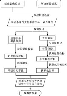
Fig.1
Sample generating process based on historical interpretation results"
Tab.1
Code conversion"
| 地理国情信息分类码 | 深度学习的自定义编码 | ||||
|---|---|---|---|---|---|
| 代码 | 一级 | 二级 | 三级 | 代码 | 类别 |
| 100 | 种植土地 | 1 | 水田 | ||
| 110 | 水田 | 1 | |||
| 120 | 旱地 | 2 | 旱地 | ||
| 130 | 果园 | 3 | 园地 | ||
| 131 | 乔灌果园 | 3 | |||
| 132 | 藤本果园 | 3 | |||
| 133 | 草本果园 | 3 | |||
| 140 | 茶园 | 3 | |||
| 150 | 桑园 | 3 | |||
| 160 | 橡胶园 | 3 | |||
| 170 | 苗圃 | 3 | |||
| 180 | 花圃 | 3 | |||
| 190 | 其他经济苗木 | 3 | |||
| 191 | 其他乔灌经济苗木 | 3 | |||
| 192 | 其他藤本经济苗木 | 3 | |||
| 193 | 其他草本经济苗木 | 3 | |||
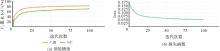
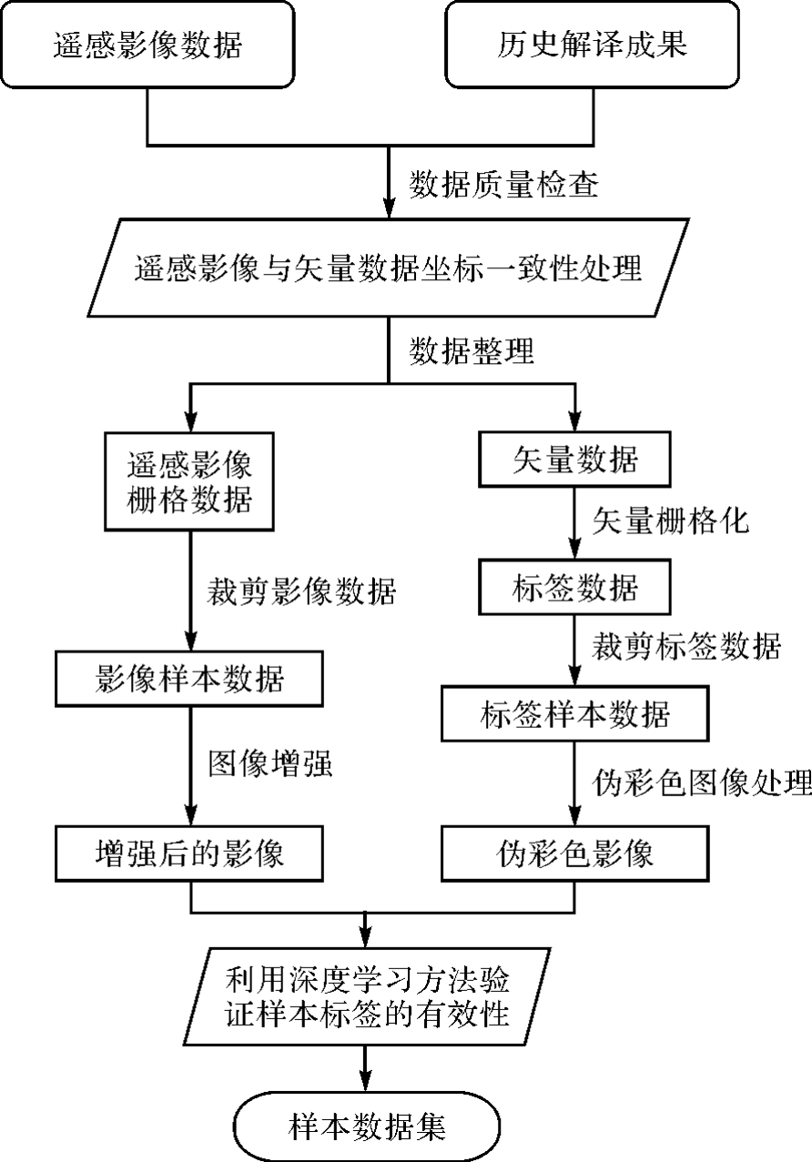
Fig.2
Accuracy index consistency analysis"

Fig.3
Example of automatic sample production"
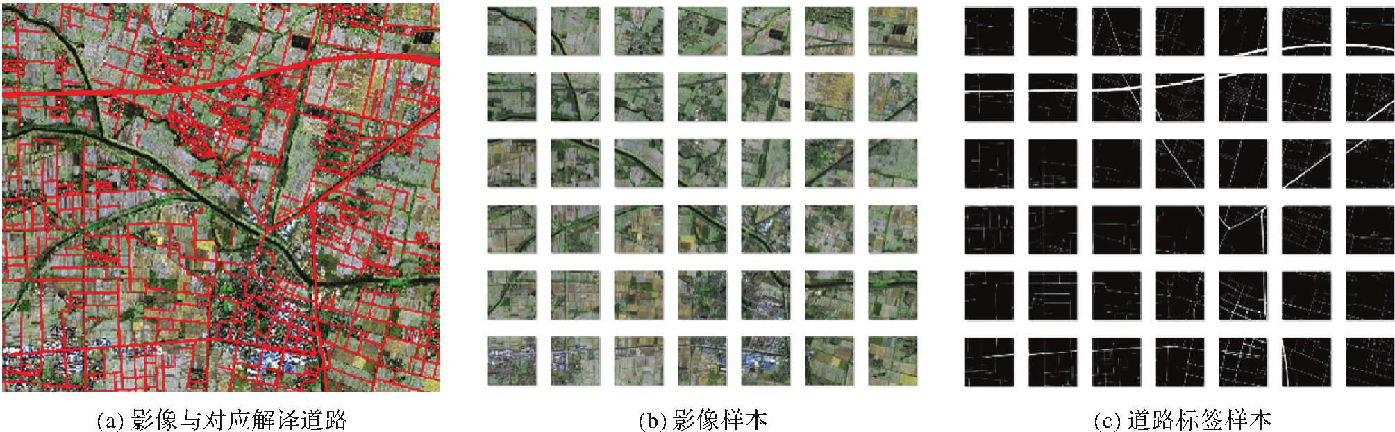

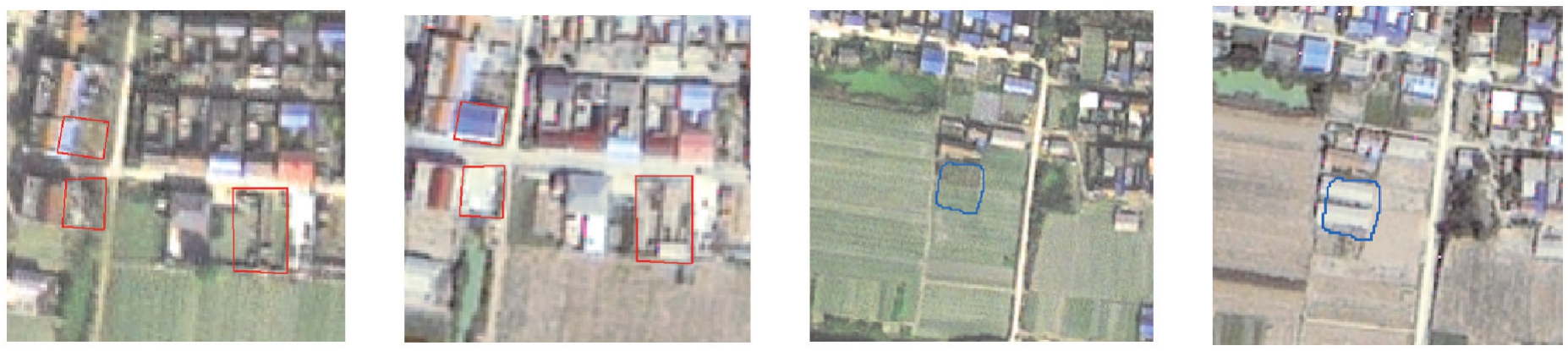
Fig.4
Sample cleaning method"
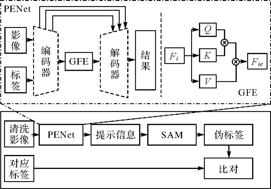
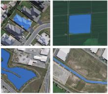
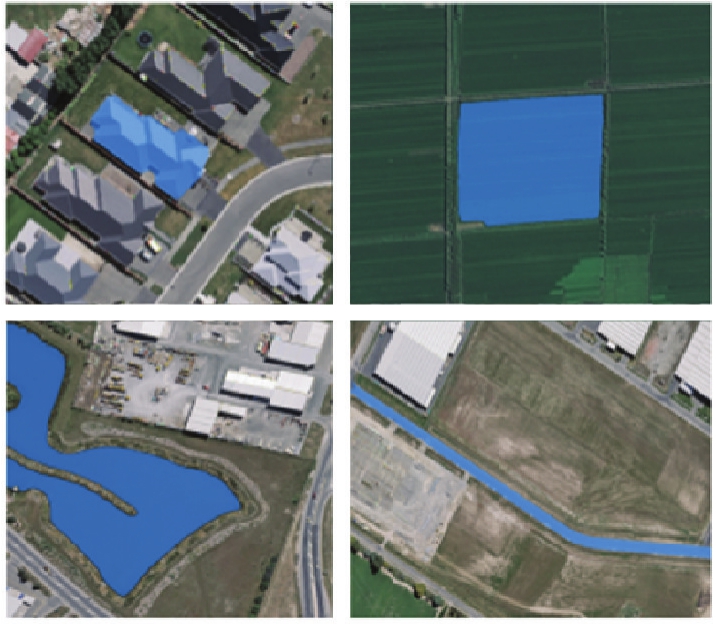
Fig.5
The refined results of SAM"
Tab.2
Design content of spatio-temporal sample dataset"
| 项目 | 内容 |
|---|---|
| 分区 | 东北、华北、华东、华中、华南、西南、西北 |
| 时相 | 覆盖全年多时相,主要考虑夏季和冬季两个差异度最大的时相,其中冬季时相的时间跨度设定为12月—次年3月,夏季时相的时间跨度设定为6—9月 |
| 地形地貌 | 平地、丘陵地、山地、高山地 |
| 影像类型 | 分辨率优于2 m的高分辨率遥感影像(如北京二号、高分一号、高分二号、资源三号等) |
| 数据集类型 | 要素提取、地表覆盖分类、变化检测 |
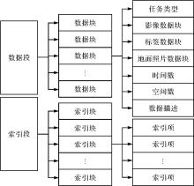
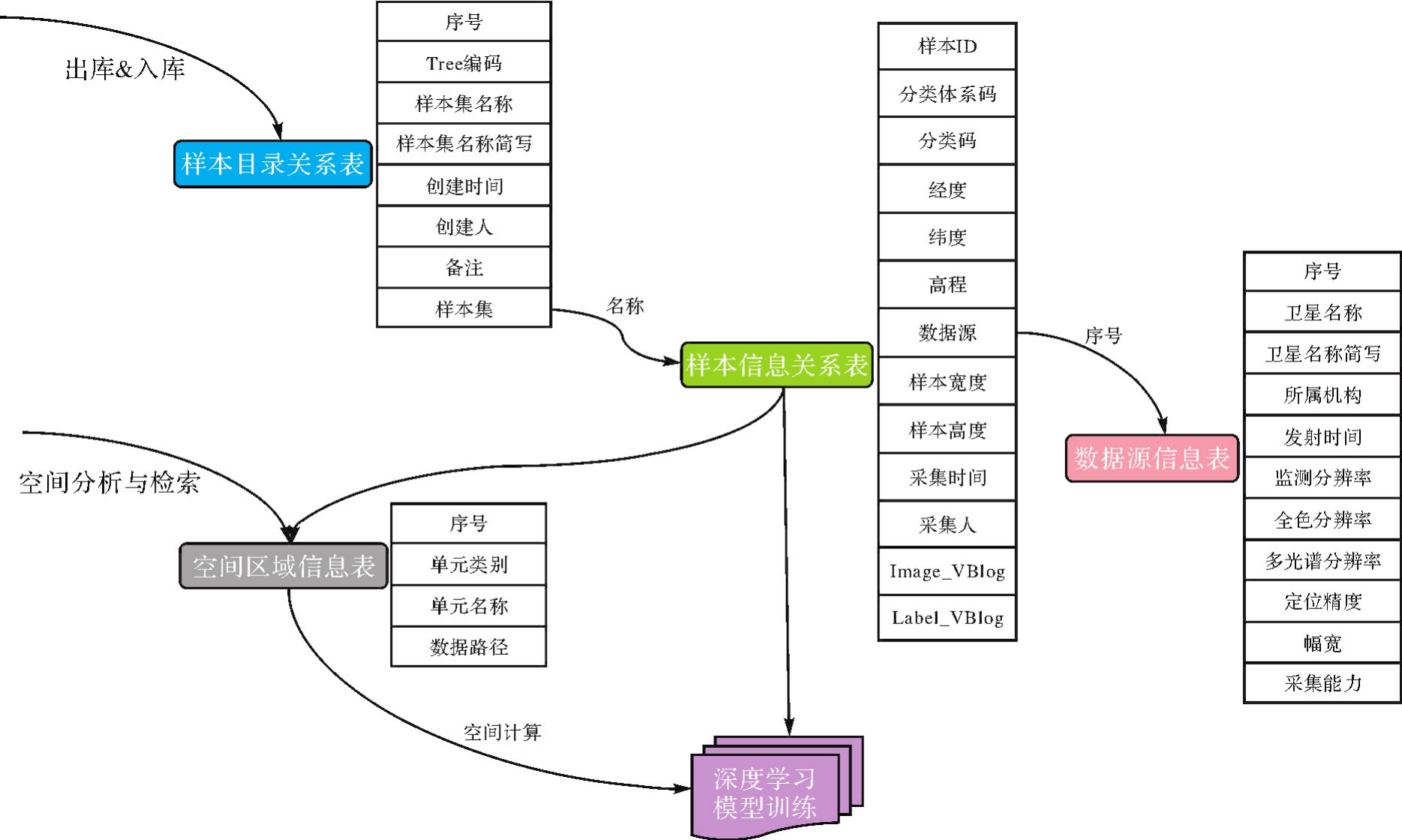
Fig.6
The structure of the dynamic sample database model"


Fig.7
The process of dynamically the sample dataset reconstruction"
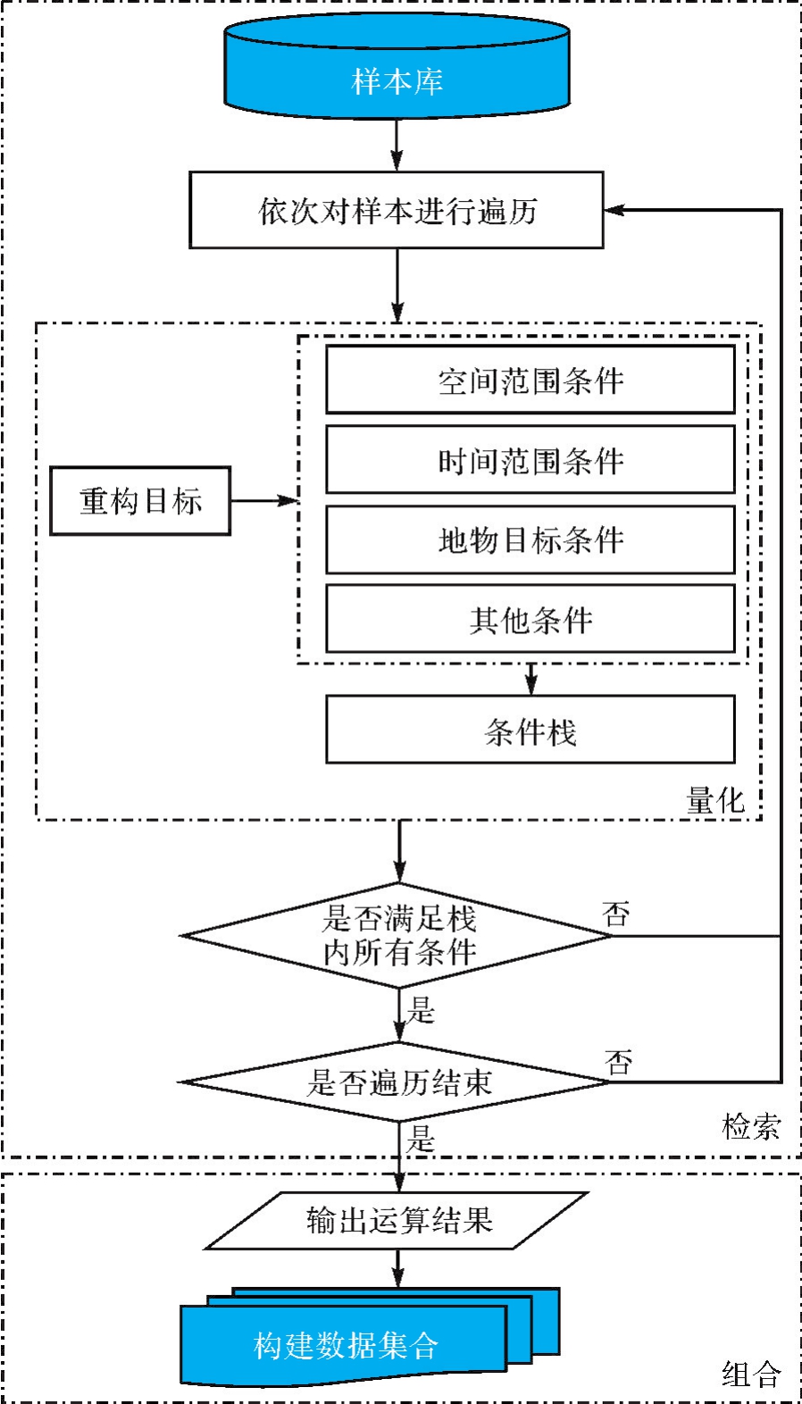

Fig.8
Sample datasets structure"
Tab.3
Sample directory relationship"
| 序号 | 字段名 | 字段简写 | 字段含义 | 填写规则 | 填写方式 | 类型 | 示例 |
|---|---|---|---|---|---|---|---|
| 1 | FID | FID | 序号ID | 自增ID | 自动 | Int | 27 |
| 2 | TreeID | TreeID | Tree编码 | 样本的Tree编码,采用3位序列编码,同层最大编码不超过1000个节点 | 自动 | String | 003029 |
| 3 | SamSet Name | YBMC | 样本集名称 | 对应并总结概括样本集中样本内容 | 人工 | String | 内蒙古耕地 |
| 4 | SampSet Nano | YBJX | 样本集名称简写 | 样本集名称的简写形式 | 人工 | String | 蒙耕地 |
| 5 | SampSetDate | JCJSJ | 创建时间 | 采集时间 | 自动 | Date | 2022-08-30 |
| 6 | Creator | JCJR | 创建人 | 操作人员姓名 | 人工 | String | 张三 |
| 7 | SampBak | JBak | 备注 | 样本集的辅助性说明 | 人工 | String | 该样本集主要针对草原生态监测有关的科研样本 |
| 8 | SampSet Link | YBJ | 样本集 | 关联样本信息表 | 自动 | String | YB3715_2022 |
Tab.4
Sample information relationship"
| 序号 | 字段名 | 字段简写 | 字段含义 | 填写规则 | 填写方式 | 类型 | 示例 |
|---|---|---|---|---|---|---|---|
| 1 | FID | FID | 数据记录ID | 自增ID | 自动 | Int | 99 |
| 2 | SampleID | YBID | 样本ID | 样本唯一标识码:数据源_X_Y | 自动 | Int | GF1293_75 |
| 3 | Classification scheme | YBCS | 分类体系码 | — | 自动 | Int | 2 |
| 4 | Classification Code | CC | 分类码 | — | 自动 | Int | |
| 5 | Longitude | X | 经度 | 度(小数) | 自动 | Double | 118.653 498 7 |
| 6 | Latitude | Y | 纬度 | 度(小数) | 自动 | Double | 41.349 348 47 |
| 7 | Elevation | Z | 高程 | 整数(米) | 自动 | Double | 155 |
| 8 | DataSource | SJY | 数据源 | 数据源信息表中序号 | 自动 | Int | 14 |
| 9 | SampleWidth | YBKD | 样本宽度 | 样本宽度(像素) | 人工 | Int | 1024 |
| 10 | Sample Height | YBGD | 样本高度 | 样本高度(像素) | 人工 | Int | 1024 |
| 11 | SampleDate | CJSJ | 采集时间 | 采集时间 | 自动 | Date | 2021-08-30 |
| 12 | Operator | CJR | 采集人 | 人名 | 人工 | String | 张某 |
| 13 | Bak | Bak | 备注 | 辅助性说明 | 人工 | String | 钢架大棚房 |
| 14 | SampleImage | YBIM | 样本影像 | 大对象 | 自动 | Blob | |
| 15 | SampleLabel | YBLB | 样本标签 | 大对象 | 自动 | Blob |
Tab.5
Data source information"
| 序号 | 国产光学卫星名称 | 卫星名称简写 | 全色分辨率/m | 多光谱分辨率/m | 幅宽/km |
|---|---|---|---|---|---|
| 1 | 北京二号 | BJ2 | 0.8 | 3.2 | 24 |
| 2 | 高分一号 | GF1 | 2 | 8 | 35 |
| 3 | 高分二号 | GF2 | 0.8 | 3.2 | 45 |
| 4 | 高分六号 | GF6 | 2 | 8 | 90 |
| 5 | 资源三号 | ZY3 | 2.1 | 5.8 | 50 |
| 6 | 高景一号 | GJ1 | 0.5 | 2 | 12 |
Tab.6
Geographical region information"
| 代码 | 地理单元类别 | 地理单元名称 | 数据路径 |
|---|---|---|---|
| 1 | 行政区域 | 全国行政区划单元(省域) | \a.shp |
| 2 | 行政区域 | 全国行政区划单元(地、市域) | \b.shp |
| 3 | 行政区域 | 全国行政区划单元(县域) | \c.shp |
| 4 | 格网 | 全国10 km地理格网单元 | \d.shp |
| 5 | 格网 | 全国5 km地理格网单元 | \e.shp |
| 6 | 格网 | 全国3 km地理格网单元 | \f.shp |
| 7 | 其他 | 其他,如地形地貌、流域、保护区、草原、粮食主产区、经济开发区等 | \** |
Fig.9
Samples of land cover classification"

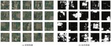
Fig.10
Samples of single feature building"
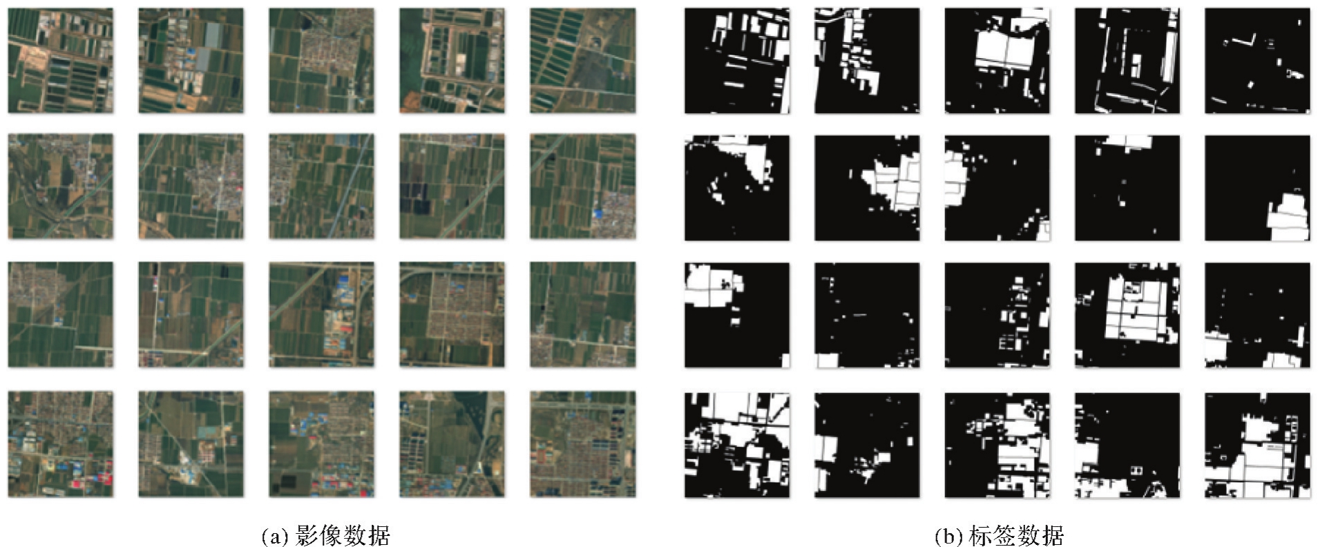
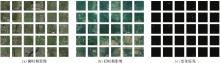
Fig.11
Samples of change detection"
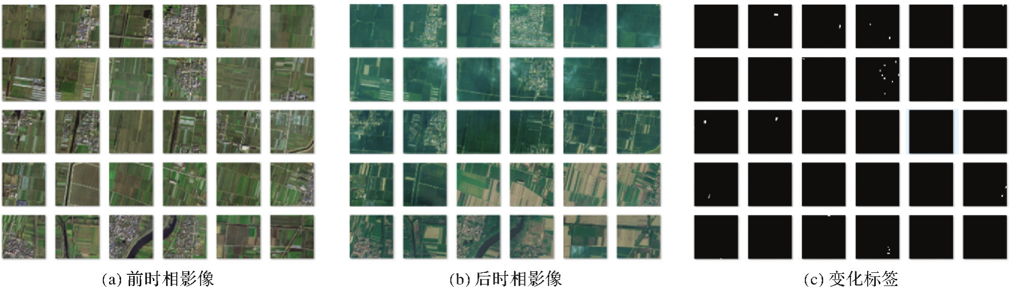

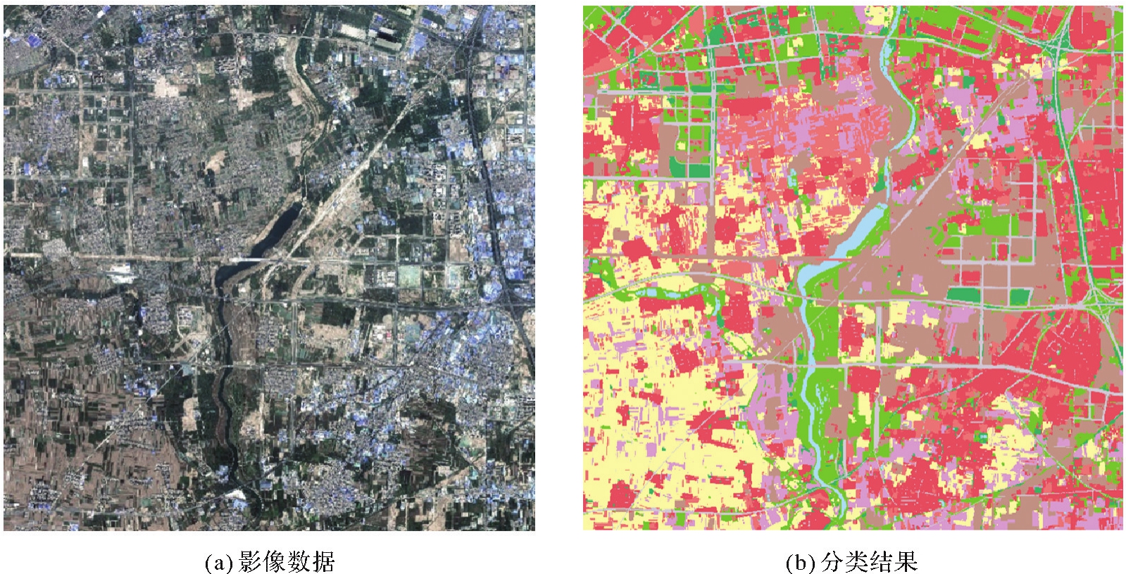
Fig.12
Land cover classification results"
Tab.7
Land cover classification accuracy"
| 指标 | 耕地 | 园地 | 林地 | 草地 | 建筑物 | 道路 | 构筑物 | 人工堆砌地 | 裸地 | 水域 | 平均 |
|---|---|---|---|---|---|---|---|---|---|---|---|
| OA | 88.95 | 81.0 | 60.49 | 83.53 | 91.0 | 67.88 | 72.21 | 88.97 | 71.04 | 75.26 | 78.03 |
| IoU | 78.41 | 68.23 | 51.16 | 66.72 | 78.4 | 56.92 | 63.08 | 79.84 | 64.63 | 68.39 | 67.58 |
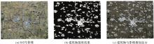
Fig.13
Building extraction results"
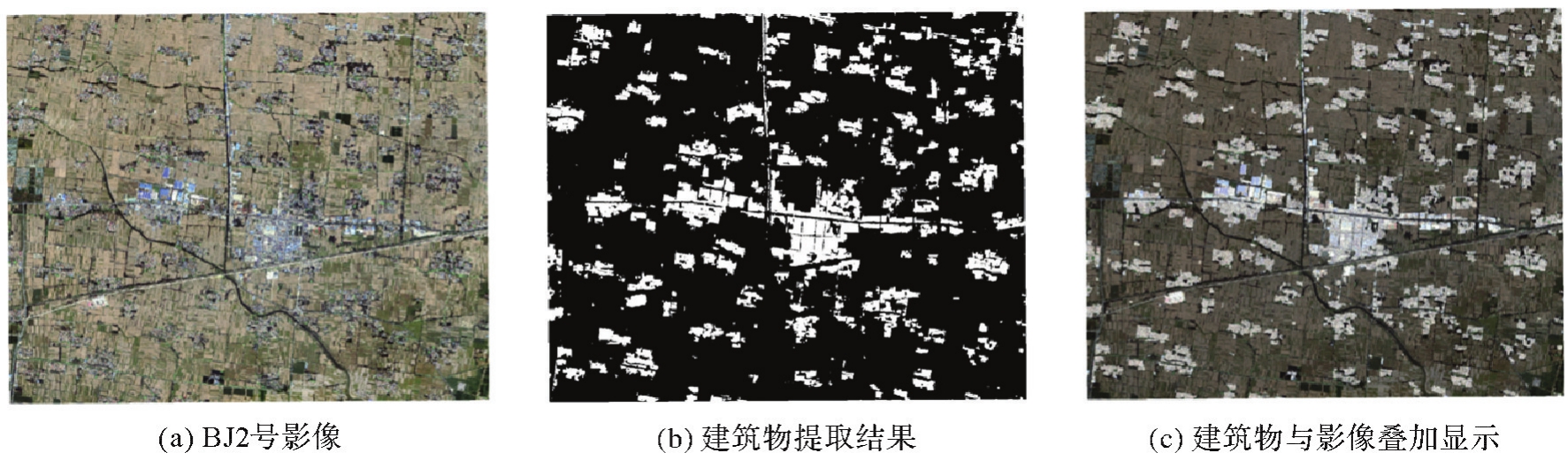
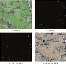
Fig.14
Results of building change detection"

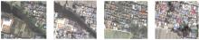
Fig.15
Results of local area change detection"
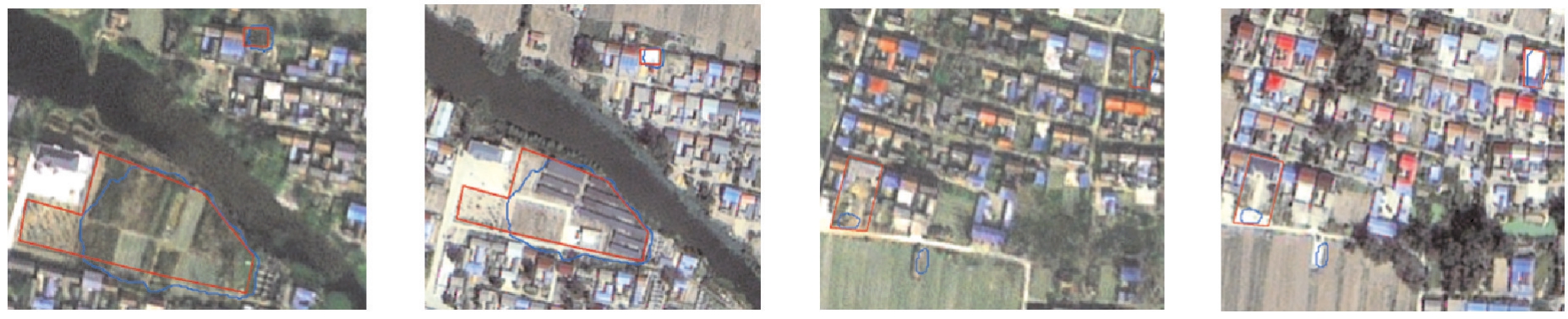

Fig.16
Miss results and error results"
| [1] | 李德仁, 童庆禧, 李荣兴, 等. 高分辨率对地观测的若干前沿科学问题[J]. 中国科学:地球科学, 2012, 42(6):805-813. |
| LI Deren, TONG Qingxi, LI Rongxing, et al. Current issues in high-resolution Earth observation technology[J]. Scientia Sinica (Terrae), 2012, 42(6):805-813. | |
| [2] | 李德仁, 王密, 沈欣, 等. 从对地观测卫星到对地观测脑[J]. 武汉大学学报(信息科学版), 2017, 42(2):143-149. |
| LI Deren, WANG Mi, SHEN Xin, et al. From earth observation satellite to earth observation brain[J]. Geomatics and Information Science of Wuhan University, 2017, 42(2):143-149. | |
| [3] | 张继贤, 顾海燕, 杨懿, 等. 高分辨率遥感影像智能解译研究进展与趋势[J]. 遥感学报, 2021, 25(11):2198-2210. |
| ZHANG Jixian, GU Haiyan, YANG Yi, et al. Research progress and trend of high-resolution remote sensing imagery intelligent interpretation[J]. National Remote Sensing Bulletin, 2021, 25(11):2198-2210. | |
| [4] | 张继贤, 李海涛, 顾海燕, 等. 人机协同的自然资源要素智能提取方法[J]. 测绘学报, 2021, 50(8):1023-1032.DOI:10.11947/j.AGCS.2021.20210102. |
| ZHANG Jixian, LI Haitao, GU Haiyan, et al. Study on man-machine collaborative intelligent extraction for natural resource features[J]. Acta Geodaetica et Cartographica Sinica, 2021, 50(8):1023-1032.DOI:10.11947/j.AGCS.2021.20210102. | |
| [5] | 冯权泷, 陈泊安, 李国庆, 等. 遥感影像样本数据集研究综述[J]. 遥感学报, 2022, 26(4):589-605. |
| FENG Quanlong, CHEN Boan, LI Guoqing, et al. A review for sample datasets of remote sensing imagery[J]. National Remote Sensing Bulletin, 2022, 26(4):589-605. | |
| [6] | 龚健雅, 许越, 胡翔云, 等. 遥感影像智能解译样本库现状与研究[J]. 测绘学报, 2021, 50(8):1013-1022. DOI:10.11947/j.AGCS.2021.20210085. |
| GONG Jianya, XU Yue, HU Xiangyun, et al. Status analysis and research of sample database for intelligent interpretation of remote sensing image[J]. Acta Geodaetica et Cartographica Sinica, 2021, 50(8):1013-1022.DOI:10.11947/j.AGCS.2021.20210085. | |
| [7] | MNIH V. Machine learning for aerial image labeling[D]. Toronto: University of Toronto, 2013. |
| [8] | LU Xiaoqiang, WANG Binqiang, ZHENG Xiangtao, et al. Exploring models and data for remote sensing image caption generation[J]. IEEE Transactions on Geoscience and Remote Sensing, 2018, 56(4):2183-2195. |
| [9] | MAGGIORI E, TARABALKA Y, CHARPIAT G, et al. Can semantic labeling methods generalize to any city? The Inria aerial image labeling benchmark[C]//Proceedings of 2017 IEEE International Geoscience and Remote Sensing Symposium. Fort Worth: IEEE, 2017. |
| [10] | JI Shunping, WEI Shiqing, LU Meng. Fully convolutional networks for multisource building extraction from an open aerial and satellite imagery dataset[J]. IEEE Transactions on Geoscience and Remote Sensing, 2019, 57(1):574-586. |
| [11] | YANG Yongke, XIAO Pengfeng, FENG Xuezhi, et al. Accuracy assessment of seven global land cover datasets over China[J]. ISPRS Journal of Photogrammetry and Remote Sensing, 2017, 125:156-173. |
| [12] | FRIEDLM A, SULLA-MENASHE D, TAN Bin, et al. MODIS collection 5 global land cover: algorithm refinements and characterization of new datasets[J]. Remote Sensing of Environment, 2010, 114(1):168-182. |
| [13] | JOHNSON B, XIE Zhixiao. Classifying a high resolution image of an urban area using super-object information[J]. ISPRS Journal of Photogrammetry and Remote Sensing, 2013, 83:40-49. |
| [14] | VOLPI M, FERRARI V. Semantic segmentation of urban scenes by learning local class interactions[C]//Proceedings of 2015 IEEE Conferenceon Computer Vision and Pattern Recognition Workshops. Boston: IEEE, 2015. |
| [15] | TONG Xinyi, XIA Guisong, LU Qikai, et al. Land-cover classification with high-resolution remote sensing images using transferable deep models[J]. Remote Sensing of Environment, 2020, 237:111322. |
| [16] | TIAN Shiqi, ZHENG Zhuo, MA Ailong, et al. Hi-UCD: a large-scale dataset for urban semantic change detection in remote sensing imagery[EB/OL]. [2023-10-08]. https://arxiv.org/pdf/2011.03247. |
| [17] | CHEN Hao, SHI Zhenwei. A spatial-temporal attention-based method and a new dataset for remote sensing image change detection[J]. Remote Sensing, 2020, 12(10):1662. |
| [18] | PETRIŞOR A. Assessment of the green infrastructure of bucharest using corine and urban atlas data[J]. Urbanism, Arhitectura, Constructii, 2015, 6(2):19-24. |
| [19] | LONG Yang, XIA Guisong, LI Shengyang, et al. On creating benchmark dataset for aerial image interpretation: reviews, guidances, and million-AID[J]. IEEE Journal of Selected Topics in Applied Earth Observations and Remote Sensing, 2021, 14:4205-4230. |
| [20] | ZUO Yi, LI Lingling, LIU Xu, et al. Robust instance-based semi-supervised learning change detection for remote sensing images[J]. IEEE Transactions on Geoscience and Remote Sensing, 2024, 62:1-15. |
| [21] | WANG Lukang, ZHANG Min, SHI Wenzhong. CS-WSCDNet: class activation mapping and segment anything model-based framework for weakly supervised change detection[J]. IEEE Transactions on Geoscience and Remote Sensing, 2023, 61:1-12. |
| [22] | RUSSELL B C, TORRALBA A, MURPHY K P, et al. LabelMe: a database and web-based tool for image annotation[J]. International Journal of Computer Vision, 2008, 77(1):157-173. |
| [23] | DUTTA A, ZISSERMAN A. The VIA annotation software for images, audio and video[C]//Proceedings of the 27th ACM International Conference on Multimedia. Nice: ACM Press, 2019: 2276-2279. |
| [24] | CASTREJON L, KUNDU K, URTASUN R, et al. Annotating object instances with a polygon-RNN[C]//Proceedings of 2017 IEEE Conference on Computer Vision and Pattern Recognition. Honolulu: IEEE, 2017. |
| [25] | ACUNA D, LING Huan, KAR A, et al. Efficient interactive annotation of segmentation datasets with polygon-RNN++[C]//Proceedings of 2018 IEEE/CVF Conferenceon Computer Vision and Pattern Recognition. Salt Lake City: IEEE, 2018: 859-868. |
| [26] | KIRILLOV A, MINTUN E, RAVI N, et al. Segment anything[EB/OL]. [2023-10-08]. https://arxiv.org/abs/2304.02643. |
| [27] | ZOU Xueyan, YANG Jianwei, ZHANG Hao, et al. Segment everything everywhere all at once[EB/OL]. [2023-10-08]. https://arxiv.org/pdf/2304.06718. |
| [28] | ZHANG Chaoning, HAN Dongshen, QIAO Yu, et al. Faster segment anything: towards lightweight SAM for mobile applications[EB/OL]. [2023-10-08]. https://arxiv.org/pdf/2306.14289. |
| [29] | XIONG Yunyang, VARADARAJAN B, WU Lemeng, et al. EfficientSAM: leveraged masked image pretraining for efficient segment anything[EB/OL]. [2023-10-08]. https://arxiv.org/pdf/2312.00863. |
| [30] | SONG Yanfei, PU Bangzheng, WANG Peng, et al. SAM-lightening: alightweight segment anything model with dilated flash attention to achieve 30 times acceleration[EB/OL]. [2023-10-08]. https://arxiv.org/pdf/2403.09195. |
| [31] | 蒋正锋, 何韬, 施艳玲, 等. 融合卷积注意力机制与深度残差网络的遥感图像分类[J]. 激光杂志, 2022, 43(4):76-81. |
| JIANG Zhengfeng, HE Tao, SHI Yanling, et al. Remote sensing image classification based on convolutional block attention module and deep residual network[J]. Laser Journal, 2022, 43(4):76-81. | |
| [32] | 李道纪, 郭海涛, 卢俊, 等. 遥感影像地物分类多注意力融和U型网络法[J]. 测绘学报, 2020, 49(8):1051-1064.DOI:10.11947/j.AGCS.2020.20190407. |
| LI Daoji, GUO Haitao, LU Jun, et al. A remote sensing image classification procedure based on multilevel attention fusion U-Net[J]. Acta Geodaetica et Cartographica Sinica, 2020, 49(8):1051-1064. DOI:10.11947/j.AGCS.2020.20190407. | |
| [33] | ZHENG Xianwei, HUAN Linxi, XIA Guisong, et al. Parsing very high resolution urban scene images by learning deep ConvNets with edge-aware loss[J]. ISPRS Journal of Photogrammetry and Remote Sensing, 2020, 170:15-28. |
| [34] | 张永生, 张振超, 童晓冲, 等. 地理空间智能研究进展和面临的若干挑战[J]. 测绘学报, 2021, 50(9):1137-1146.DOI:10.11947/j.AGCS.2021.20200420. |
| ZHANG Yongsheng, ZHANG Zhenchao, TONG Xiaochong, et al. Progress and challenges of geospatial artificial intelligence[J]. Acta Geodaetica et Cartographica Sinica, 2021, 50(9):1137-1146.DOI:10.11947/j.AGCS.2021.20200420. | |
| [35] | 史文中, 张敏. 人工智能用于遥感目标可靠性识别:总体框架设计、现状分析及展望[J]. 测绘学报, 2021, 50(8):1049-1058.DOI:10.11947/j.AGCS.2021.20210095. |
| SHI Wenzhong, ZHANG Min. Artificial intelligence for reliable object recognition from remotely sensed data: overall framework design, review and prospect[J]. Acta Geodaetica et Cartographica Sinica, 2021, 50(8):1049-1058.DOI:10.11947/j.AGCS.2021.20210095. | |
| [36] | 龚健雅, 张觅, 胡翔云, 等. 智能遥感深度学习框架与模型设计[J]. 测绘学报, 2022, 51(4):475-487.DOI:10.11947/j.AGCS.2022.20220027. |
| GONG Jianya, ZHANG Mi, HU Xiangyun, et al. The design of deep learning framework and model for intelligent remote sensing[J]. Acta Geodaetica et Cartographica Sinica, 2022, 51(4):475-487.DOI:10.11947/j.AGCS.2022.20220027. | |
| [37] | TAO Cheng, YANG Zhang, JAMES H. Network spacetime AI: concepts, methods and applications[J]. Journal of Geodesy and Geoinformation Science, 2022, 5(3):78-92. |
| [38] | GONG Jianya, JI Shunping. Photogrammetry and deep learning[J]. Journal of Geodesy and Geoinformation Science, 2018, 1(1):1-15. |
| [39] | 陈军, 刘万增, 武昊, 等. 智能化测绘的基本问题与发展方向[J]. 测绘学报, 2021, 50(8):995-1005.DOI:10.11947/j.AGCS.2021.20210235. |
| CHEN Jun, LIU Wanzeng, WU Hao, et al. Smart surveying and mapping: fundamental issues and research agenda[J]. Acta Geodaetica et Cartographica Sinica, 2021, 50(8):995-1005.DOI:10.11947/j.AGCS.2021.20210235. | |
| [40] | 陈军, 艾廷华, 闫利, 等. 智能化测绘的混合计算范式与方法研究[J/OL]. 测绘学报: 1-19 [2024-05-18]. http://kns.cnki.net/kcms/detail/11.2089.P.20240415.1049.002.html. |
| CHEN Jun, AI Tinghua, YAN Li, et al. Hybrid computational paradigm and methods for intelligentized surveying and mapping[J/OL]. Acta Geodaetica et Cartographica Sinica: 1-19 [2024-05-18]. http://kns.cnki.net/kcms/detail/11.2089.P.20240415.1049.002.html. | |
| [41] | CHEN Jun, LI Zhilin, LI songnian, et al. From digitalized to intelligentized surveying and mapping: fundamental issues and research agenda[J]. Journal of Geodesy and Geoinformation Science, 2022, 5(2):148-160. DOI:10.11947/j.JGGS.2022.0213. |
| [1] | Lanxin WU, Jiangtao PENG, Weiwei SUN, Bing YANG. An Euler embedding and complementary feature modeling framework for hyperspectral change detection in coastal wetlands [J]. Acta Geodaetica et Cartographica Sinica, 2026, 55(4): 618-631. |
| [2] | Jiayao WANG, Lin CHEN, Shiyuan CHENG, Lijun WANG, Siqi XIONG. Artificial intelligence empowering the digital-intelligent transformation of cartographic science [J]. Acta Geodaetica et Cartographica Sinica, 2026, 55(3): 381-389. |
| [3] | Xiaomin LU, Zhiyi ZHANG, Haowen YAN, Yi HE, Xiaoning SU. A recognition method for building group pattern integrating deep graph infomax and multilayer perceptron [J]. Acta Geodaetica et Cartographica Sinica, 2026, 55(3): 425-438. |
| [4] | Daifeng PENG, Xuelian LIU, Mengfei LU, Haiyan GUAN. Heterogeneous remote sensing image flood change detection based on multi-scale cross-modal feature fusion [J]. Acta Geodaetica et Cartographica Sinica, 2026, 55(2): 328-343. |
| [5] | Haopeng HU, Hangbin WU, Shihao ZHAN, Zaihao WEN, Chun LIU. Road pole-like object change detection supported by visual point cloud quality optimization [J]. Acta Geodaetica et Cartographica Sinica, 2026, 55(2): 344-358. |
| [6] | Shunping JI, Jin LIU, Jian GAO, Jianya GONG. An intelligent 3D reconstruction framework via deep learning based multi-view image matching [J]. Acta Geodaetica et Cartographica Sinica, 2025, 54(9): 1633-1646. |
| [7] | Jixian ZHANG, Haiyan GU, Huan NI, Haitao LI, Yi YANG, Shaopeng DING, Songman SUI. Deep learning methods for remote sensing intelligent change detection: evolution and development [J]. Acta Geodaetica et Cartographica Sinica, 2025, 54(8): 1347-1370. |
| [8] | Shuai FANG, Jiaen LIU, Jing ZHANG. Spatio-temporal fusion algorithm based on adaptive reference feature incorporation and multi-scale feature aggregation [J]. Acta Geodaetica et Cartographica Sinica, 2025, 54(8): 1476-1488. |
| [9] | Nina MENG, Fengmei LI, Xiaodong ZHOU. Data and cognition dual-driven building group generalization results and scale consistency assessment [J]. Acta Geodaetica et Cartographica Sinica, 2025, 54(7): 1318-1331. |
| [10] | Yaqing WANG, Zhonghui WANG. River network automated selection method based on heterogeneous graph convolutional networks [J]. Acta Geodaetica et Cartographica Sinica, 2025, 54(7): 1332-1345. |
| [11] | Xiaoya AN, Weiru GUO, Pengxin ZHANG, Xinxin LI, Lei SHI. Ship trajectories clustering method considering similarity in geometric position and mobility features [J]. Acta Geodaetica et Cartographica Sinica, 2025, 54(6): 1107-1121. |
| [12] | Haifeng LI, Wang GUO, Mengwei WU, Chengli PENG, Qing ZHU, Yu LIU, Chao TAO. Visual-language joint representation and intelligent interpretation of remote sensing geo-objects: principles, challenges and opportunities [J]. Acta Geodaetica et Cartographica Sinica, 2025, 54(5): 853-872. |
| [13] | Chao WANG, Tianyu CHEN, Tong ZHANG, Tanvir AHMED, Liqiang JI, Tao XIE, Jiajun YANG, Shuai WANG. Multi-sensor optical remote sensing images change detection based on global differential enhancement module and balance penalty loss [J]. Acta Geodaetica et Cartographica Sinica, 2025, 54(5): 873-887. |
| [14] | Qingli LUO, Xueyan LI, Guoman HUANG, Honghui CHEN, Minglong XUE, Jian LI. AOSN: alpha optimal structure network for height estimation from a single SAR image in mountain areas [J]. Acta Geodaetica et Cartographica Sinica, 2025, 54(5): 888-898. |
| [15] | Wei TU, Xiangyuan CHI, Tianhong ZHAO, Jian YANG, Shiping ZHU, Deli CHEN. Multi-view spatio-temporal graph convolutional networks model for urban drainage networks flow prediction [J]. Acta Geodaetica et Cartographica Sinica, 2025, 54(2): 334-344. |
| Viewed | ||||||
|
Full text |
|
|||||
|
Abstract |
|
|||||