

Acta Geodaetica et Cartographica Sinica ›› 2026, Vol. 55 ›› Issue (5): 798-808.doi: 10.11947/j.AGCS.2026.20250376
• BDS/GNSS and Multi-Sensor Fusion for PNT • Previous Articles Next Articles
Feng ZHU1( ), Yuanmu LIAO1, Rui ZHOU1, Xiaohong ZHANG1,2()
Received:2025-09-16
Revised:2026-04-16
Online:2026-06-23
Published:2026-06-23
Contact:
Xiaohong ZHANG
E-mail:fzhu@whu.edu.cn;xhzhang@sgg.whu.edu.cn
About author:ZHU Feng (1989—), male, PhD, associate professor, majors in GNSS precise positioning and multi-sensor fusion navigation. E-mail: fzhu@whu.edu.cn
Supported by:CLC Number:
Feng ZHU, Yuanmu LIAO, Rui ZHOU, Xiaohong ZHANG. Continuous-time state estimation methods for multi-sensor fusion navigation[J]. Acta Geodaetica et Cartographica Sinica, 2026, 55(5): 798-808.
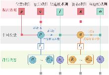
Fig. 1
A continuous-time state estimation framework for multi-sensor fusion"
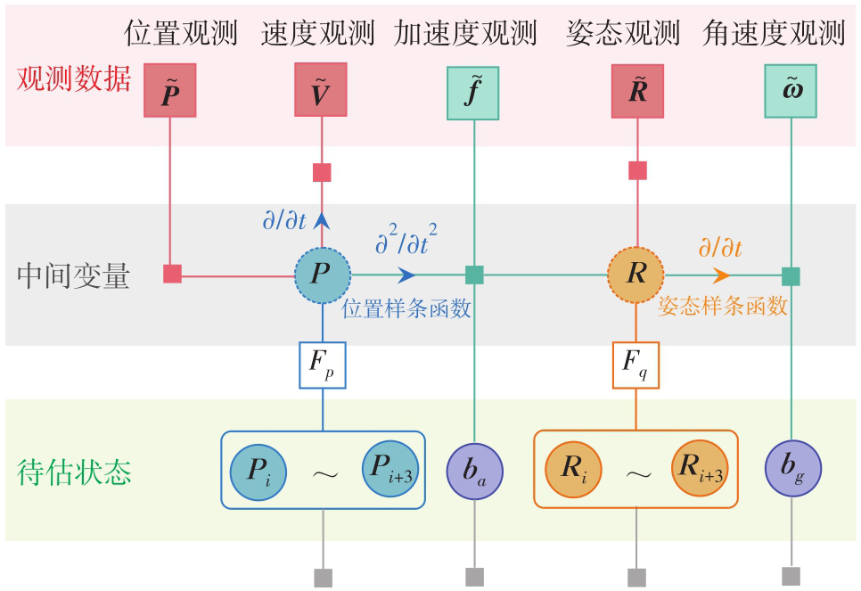
Fig. 2
Continuous-time state system design"
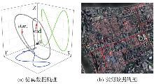
Fig. 3
Vehicle motion trajectory"

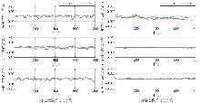
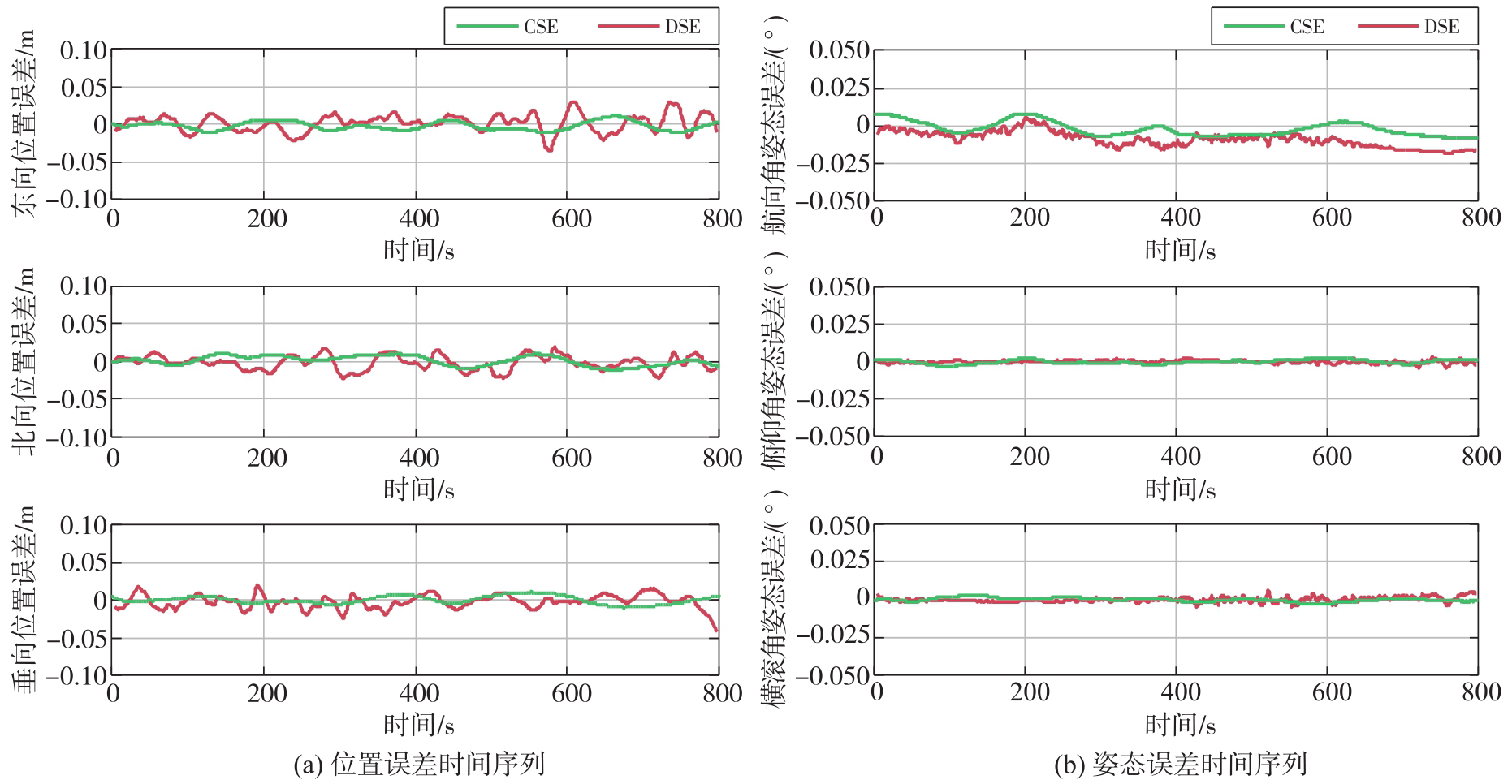
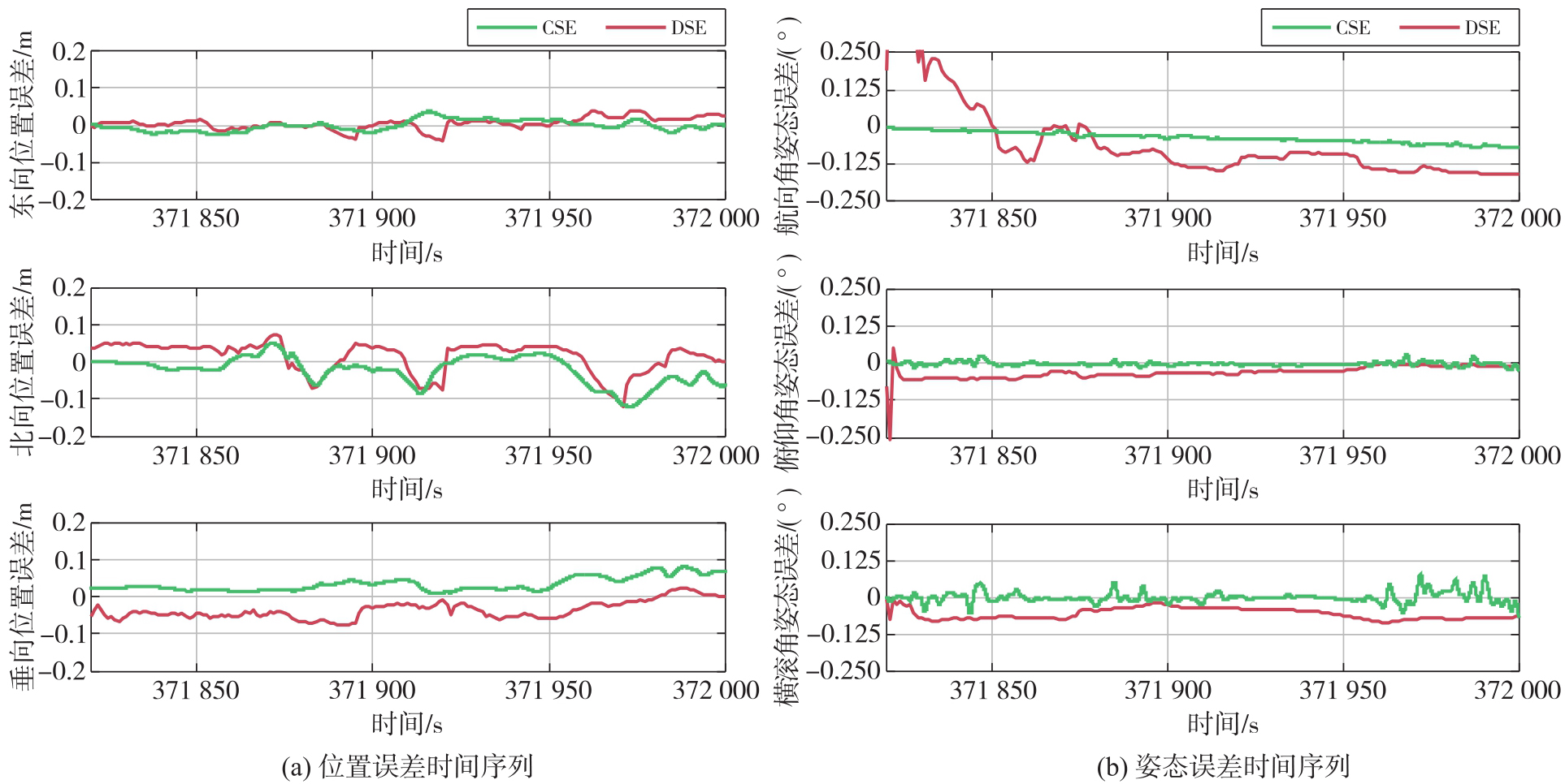
Fig. 4
Pose error time series during normal data operation"
Tab. 1
RMS of pose errors during normal data operation"
| 误差类型 | 分量 | RMS | 精度提升/(%) | |
|---|---|---|---|---|
| DSE | CSE | |||
| 位置误差/cm | 东向 | 1.14 | 0.60 | 47.4 |
| 北向 | 0.96 | 0.64 | 33.3 | |
| 垂向 | 0.92 | 0.52 | 43.5 | |
| 姿态误差/arcmin | 航向角 | 0.62 | 0.31 | 50.0 |
| 俯仰角 | 0.08 | 0.06 | 25.0 | |
| 横滚角 | 0.10 | 0.07 | 30.0 | |
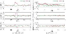
Fig. 5
Pose error time series during GNSS signal loss"
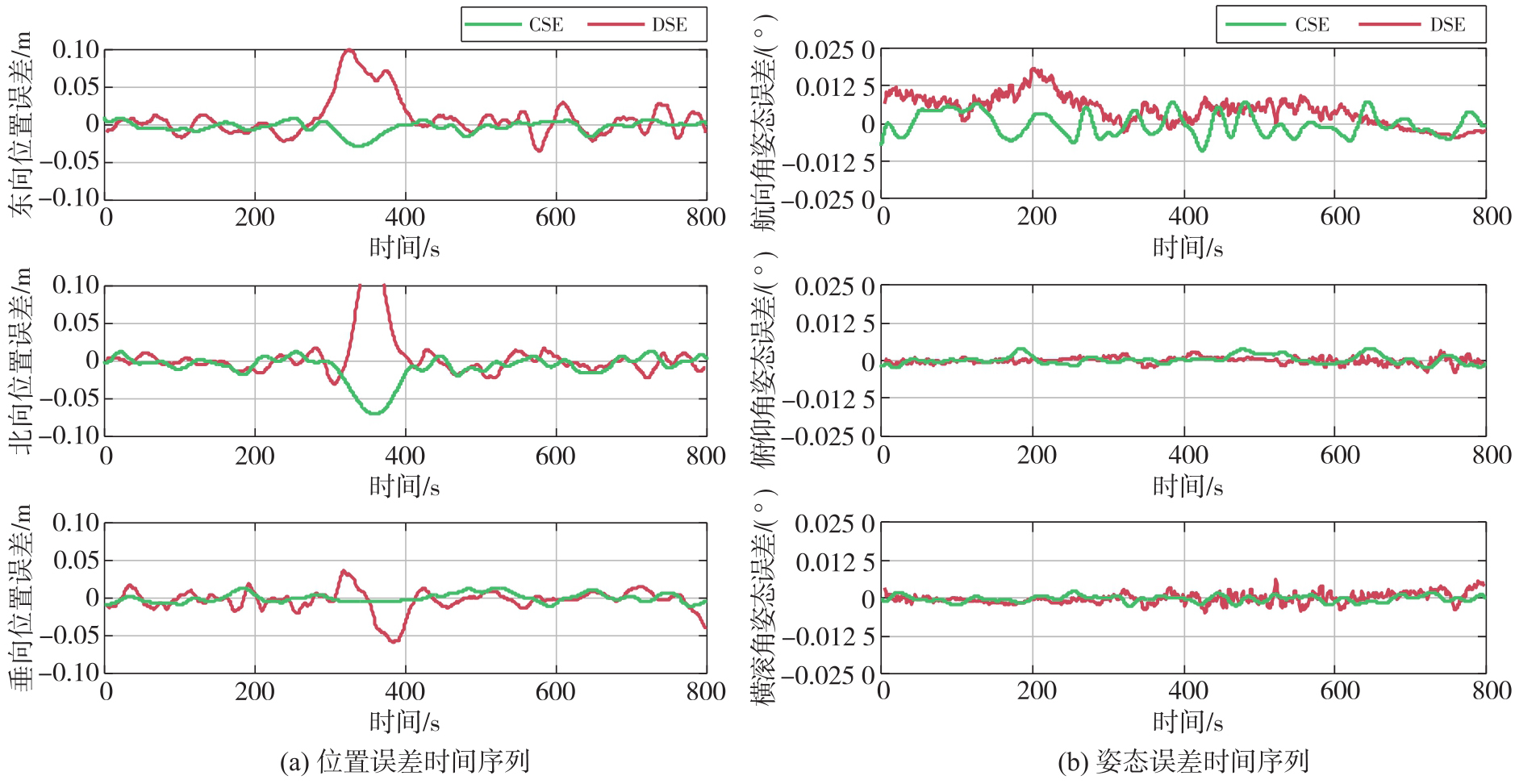
Tab. 2
The maximum pose errors during GNSS signal loss"
| 误差类型 | 分量 | 最大误差 | 精度提升/(%) | |
|---|---|---|---|---|
| DSE | CSE | |||
| 位置误差/cm | 东向 | 10.08 | 2.80 | 72.2 |
| 北向 | 15.94 | 7.02 | 55.9 | |
| 垂向 | 5.90 | 1.35 | 77.1 | |
| 姿态误差/arcmin | 航向角 | 1.10 | 0.54 | 50.9 |
| 俯仰角 | 0.25 | 0.24 | 4.0 | |
| 横滚角 | 0.38 | 0.15 | 60.5 | |
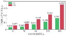
Fig. 6
Comparison of maximum 3D positioning errors under different GNSS signal outage durations"

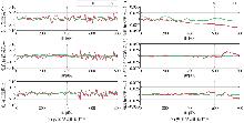
Fig. 7
Pose error time series during IMU data outage"
Tab. 3
RMS of pose errors during INS data outage"
| 误差类型 | 分量 | RMS | 精度提升/(%) | |
|---|---|---|---|---|
| DSE | CSE | |||
| 位置误差/cm | 东向 | 1.44 | 0.90 | 37.5 |
| 北向 | 1.91 | 0.82 | 57.1 | |
| 垂向 | 1.76 | 0.88 | 50.0 | |
| 姿态误差/arcmin | 航向角 | 1.64 | 0.39 | 76.2 |
| 俯仰角 | 0.50 | 0.11 | 78.0 | |
| 横滚角 | 0.50 | 0.10 | 80.0 | |
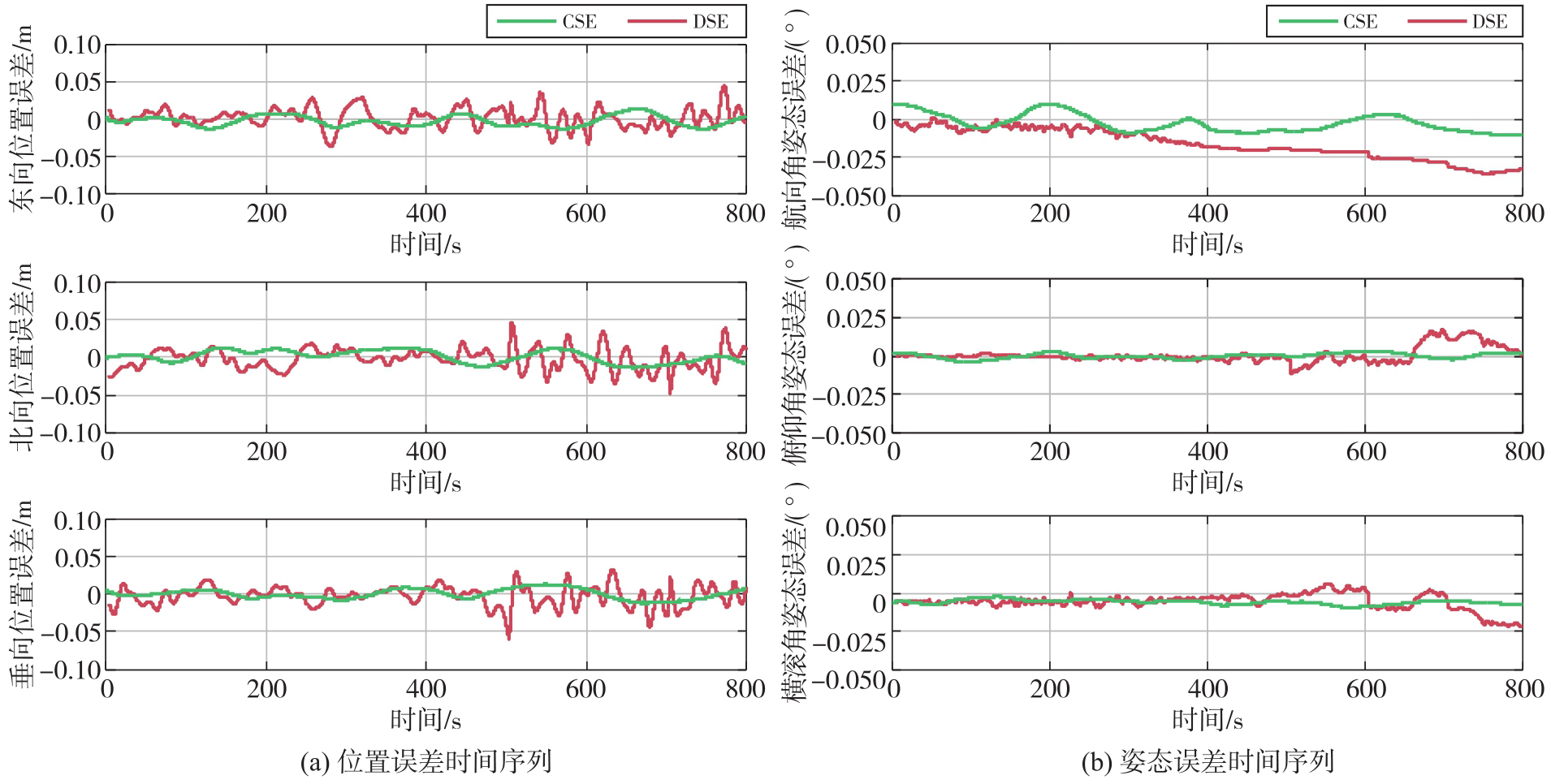
Fig. 8
Pose error time series from actual measurement data"
| [1] |
李德仁, 洪勇, 王密, 等. 测绘遥感能为智能驾驶做什么?[J]. 测绘学报, 2021, 50(11): 1421-1431. DOI: .
doi: 10.11947/j.AGCS.2021.20210280 |
|
LI Deren, HONG Yong, WANG Mi, et al. What can photogrammetry and remote sensing do for intelligent driving?[J]. Acta Geodaetica et Cartographica Sinica, 2021, 50(11): 1421-1431. DOI: .
doi: 10.11947/j.AGCS.2021.20210280 |
|
| [2] |
杨元喜. 综合PNT体系及其关键技术[J]. 测绘学报, 2016, 45(5): 505-510. DOI: .
doi: 10.11947/j.AGCS.2016.20160127 |
|
YANG Yuanxi. Integrated PNT system and its key technologies[J]. Acta Geodaetica et Cartographica Sinica, 2016, 45(5): 505-510. DOI: .
doi: 10.11947/j.AGCS.2016.20160127 |
|
| [3] | 赵万龙, 孟维晓, 韩帅. 多源融合导航技术综述[J]. 遥测遥控, 2016, 37(6): 54-60. |
| ZHAO Wanlong, MENG Weixiao, HAN Shuai. A survey of multi-source fusion navigation technology[J]. Journal of Telemetry, Tracking and Command, 2016, 37(6): 54-60. | |
| [4] | BARFOOT T D. State estimation for robotics[M]. Cambridge: Cambridge University Press, 2017: 55-86. |
| [5] | MOURIKIS A I, ROUMELIOTIS S I. A multi-state constraint Kalman filter for vision-aided inertial navigation[C]//Proceedings of 2007 IEEE International Conference on Robotics and Automation. Piscataway: IEEE, 2007: 3565-3572. |
| [6] | 徐昊玮, 廉保旺, 刘尚波. 基于滑动窗迭代最大后验估计的多源组合导航因子图融合算法[J]. 兵工学报, 2019, 40(4): 807-819. |
| XU Haowei, LIAN Baowang, LIU Shangbo. A factor graph fusion algorithm for multi-source integrated navigation based on sliding window iterative maximum a posteriori estimation[J]. Acta Armamentarii, 2019, 40(4): 807-819. | |
| [7] | DELLAERT F, KAESS M. Factor graphs for robot perception[M]. Boston-Delft: Now Publishers, 2017: 19-24. |
| [8] | QIN Tong, LI Peiliang, SHEN Shaojie. VINS-mono: a robust and versatile monocular visual-inertial state estimator[J]. IEEE Transactions on Robotics, 2018, 34(4): 1004-1020. |
| [9] | SHAN Tixiao, ENGLOT B, MEYERS D, et al. LIO-SAM: tightly-coupled lidar inertial odometry via smoothing and mapping[C]//Proceedings of 2020 IEEE/RSJ International Conference on Intelligent Robots and Systems. Las Vegas: IEEE, 2020: 5135-5142. |
| [10] | LYNEN S, ACHTELIK M W, WEISS S, et al. A robust and modular multi-sensor fusion approach applied to MAV navigation[C]//Proceedings of 2013 IEEE International Conference on Robotics and Automation. Tokyo: IEEE, 2013: 3924-3931. |
| [11] | LÜ Jiajun, LANG Xiaobei, XU Jinhong, et al. Continuous-time fixed-lag smoothing for LiDAR-inertial-camera SLAM[J]. IEEE Transactions on Robotics, 2023, 39(4): 3017-3032. |
| [12] | FURGALE P, BARFOOT T D, SIBLEY G. Continuous-time batch estimation using temporal basis functions[C]//Proceedings of 2012 IEEE International Conference on Robotics and Automation. Piscataway: IEEE, 2012: 2088-2095. |
| [13] | FURGALE P, REHDER J, SIEGWART R. Unified temporal and spatial calibration for multi-sensor systems[C]//Proceedings of 2013 IEEE/RSJ International Conference on Intelligent Robots and Systems. Tokyo: IEEE, 2013: 1280-1286. |
| [14] | FURGALE P, TONG C H, BARFOOT T D, et al. Continuous-time batch trajectory estimation using temporal basis functions[J]. International Journal of Robotics Research, 2015, 34(14): 1688-1710. |
| [15] | 吕佳俊, 郎晓磊, 李宝润, 等. 基于B样条的连续时间轨迹状态估计研究综述[J]. 机器人, 2024, 46(6): 743-752. |
| LÜ Jiajun, LANG Xiaolei, LI Baorun, et al. Review of continuous-time trajectory state estimation based on B-splines[J]. Robot, 2024, 46(6): 743-752. | |
| [16] | QIAN Kun, WANG Jianguo, HU Baoxin. Novel integration strategy for GNSS-aided inertial integrated navigation[J]. Geomatica, 2015, 69(2): 217-230. |
| [17] | WU Yuanxin. iNavFIter: next-generation inertial navigation computation based on functional iteration[J]. IEEE Transactions on Aerospace and Electronic Systems, 2022, 58(5): 4220-4233. |
| [18] | ZHANG Hongyu, ZHU Maoran, CAI Qi, et al. Visual-inertial state estimation based on Chebyshev polynomial optimization[J]. IEEE Sensors Journal, 2025, 25(15): 29618-29629. |
| [19] | LANG Xiaolei, CHEN Chao, TANG Kai, et al. Coco-LIC: continuous-time tightly-coupled LiDAR-inertial-camera odometry using non-uniform B-spline[J]. IEEE Robotics and Automation Letters, 2023, 8(11): 7074-7081. |
| [20] | 高翔, 张涛, 刘毅, 等. 视觉SLAM十四讲:从理论到实践[M]. 2版. 北京: 电子工业出版社, 2019: 70-75. |
| GAO Xiang, ZHANG Tao, LIU Yi, et al. Fourteen lectures on visual SLAM: from theory to practice[M]. 2nd ed. Beijing: Publishing House of Electronics Industry, 2019: 70-75. | |
| [21] | QIN Kaihuai. General matrix representations for B-splines[C]//Proceedings of 1998 IEEE International Conference on Systems, Man, and Cybernetics. Singapore: IEEE, 1998: 3903-3908. |
| [22] | OVRÉN H, FORSSÉN P E. Trajectory representation and landmark projection for continuous-time structure from motion[J]. The International Journal of Robotics Research, 2019, 38(6): 686-701. |
| [23] | SOLÀ J, DERAY J, ATCHUTHAN D. A micro Lie theory for state estimation in robotics[J]. arXiv Preprint, 2018(11): 1-17. |
| [24] | SOMMER C, USENKO V, SCHUBERT D, et al. Efficient derivative computation for cumulative B-splines on lie groups[C]//Proceedings of 2020 IEEE/CVF Conference on Computer Vision and Pattern Recognition. Seattle: IEEE, 2020: 11145-11153. |
| [25] |
张小红, 胡家欢, 任晓东. PPP/PPP-RTK新进展与北斗/GNSS PPP定位性能比较[J]. 测绘学报, 2020, 49(9): 1084-1100. DOI: .
doi: 10.11947/j.AGCS.2020.20200328 |
|
ZHANG Xiaohong, HU Jiahuan, REN Xiaodong. New progress of PPP/PPP-RTK and positioning performance comparison of BDS/GNSS PPP[J]. Acta Geodaetica et Cartographica Sinica, 2020, 49(9): 1084-1100. DOI: .
doi: 10.11947/j.AGCS.2020.20200328 |
| [1] | Linghan YAO, Tianhe XU, Yangzi CONG, Zhen ZHANG, Jianping XING. Tightly coupled LiDAR/UWB/INS multi-sensor fusion model based on IESRKF [J]. Acta Geodaetica et Cartographica Sinica, 2026, 55(5): 809-825. |
| [2] | Jianghui GENG, Feng WANG. Componentized PNT framework for blind-plug-and-play multi-sensor fusion and its principles and experimental verification [J]. Acta Geodaetica et Cartographica Sinica, 2026, 55(5): 787-797. |
| [3] | Rui ZHOU, Feng ZHU, Xiaohong ZHANG. Camera-IMU extrinsic calibration based on prior poses and motion planning [J]. Acta Geodaetica et Cartographica Sinica, 2026, 55(3): 465-476. |
| [4] | Weitong WU, Chi CHEN, Bisheng YANG, Xiufeng HE. Robust multi-sensor fusion-based odometry method of LiDAR, millimeter-wave radar and IMU in degraded scenes [J]. Acta Geodaetica et Cartographica Sinica, 2025, 54(9): 1677-1686. |
| [5] | WANG Xuanbin, LI Xingxing, LIAO Jianchi, FENG Shaoquan, LI Shengyu, ZHOU Yuxuan. Tightly-coupled stereo visual-inertial-LiDAR SLAM based on graph optimization [J]. Acta Geodaetica et Cartographica Sinica, 2022, 51(8): 1744-1756. |
| [6] | XIE Donghai, ZHONG Ruofei, WU Yu, FU Han, HUANG Xiaochuan, SUN Zhenxing. Relative Pose Estimation and Accuracy Verification of Spherical Panoramic Image [J]. Acta Geodaetica et Cartographica Sinica, 2017, 46(11): 1822-1829. |
| [7] | DENG Fei, WU Yousi, HU Yulei, CUI Hongxia. Position and Pose Estimation of Spherical Panoramic Image with Improved EPnP Algorithm [J]. Acta Geodaetica et Cartographica Sinica, 2016, 45(6): 677-684. |
| Viewed | ||||||
|
Full text |
|
|||||
|
Abstract |
|
|||||