

Acta Geodaetica et Cartographica Sinica ›› 2026, Vol. 55 ›› Issue (3): 439-450.doi: 10.11947/j.AGCS.2026.20250466
• Geodesy and Navigation • Previous Articles Next Articles
Tangting WU1( ), Xinyu LUO1, Liguo LU1(), Zhanke LIU2, Nengfang CHAO3
Received:2025-10-28
Revised:2026-03-20
Online:2026-04-16
Published:2026-04-16
Contact:
Liguo LU
E-mail:ttwu@ecut.edu.cn;lglu66@163.com
About author:WU Tangting (1990—), female, PhD, lecturer, majors in satellite gravimetry. E-mail: ttwu@ecut.edu.cn
Supported by:CLC Number:
Tangting WU, Xinyu LUO, Liguo LU, Zhanke LIU, Nengfang CHAO. Assessment of water resource changes and drought characteristics in the Shaanxi, Gansu and Ningxia region based on GNSS and GRACE/GRACE-FO[J]. Acta Geodaetica et Cartographica Sinica, 2026, 55(3): 439-450.
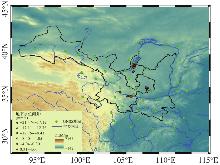
Fig. 1
Geographical location and topographic overview of the Shaanxi, Gansu and Ningxia region"
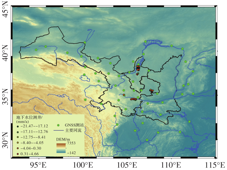
Tab. 1
List of datasets"
| 数据名称 | 数据来源 | 研究时间 | 测站点数 | 时空分辨率 | 数据下载网址 |
|---|---|---|---|---|---|
| GNSS | 中国地壳运动观测网 | 2011-01—2024-08 | 52 | 日 | |
| GRACE/GRACE-FO | 美国喷气动力实验室 | 2011-01—2024-08 | — | 0.5°/月 | |
| GLDAS | 戈达德地球科学数据与信息服务中心 | 2011-01—2024-08 | — | 0.25°/月 | |
| P、E、R、T | ERA5-Land | 2011-01—2024-08 | — | 0.25°/月 | |
| 水资源总量 | 中国统计年鉴 | 2011—2023 | — | 年 | |
| 地下水位测井 | 国家地下水监测工程信息应用服务系统 | 2018—2024 | 44 | 日 |
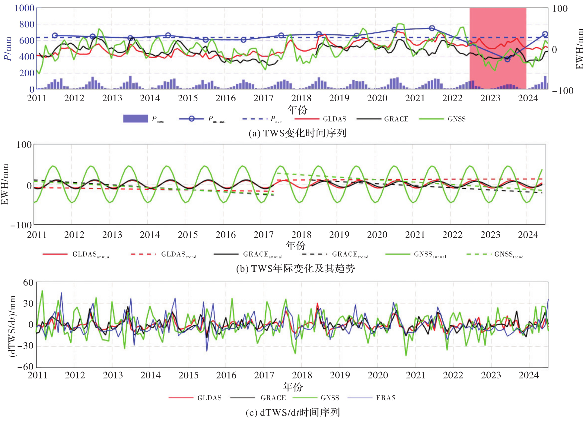
Fig. 2
Time series of TWS changes and dTWS/dt obtained from different datasets"
Tab. 2
Correlation coefficients between precipitation and TWS changes derived from different datasets"
| 相关系数 | GLDAS-TWS | GRACE-TWS | GNSS-TWS | P | Plag2m |
|---|---|---|---|---|---|
| GLDAS-TWS | — | — | — | — | — |
| GRACE-TWS | 0.66 | — | — | — | — |
| GNSS-TWS | 0.67 | 0.66 | — | — | — |
| P | 0.39 | 0.14 | 0.56 | — | — |
| Plag2m | 0.82 | 0.55 | 0.61 | 0.42 | — |
Fig. 3
Annual amplitude ((a)—(c)) and phase of TWS ((d)—(f)) obtained from different datasets"
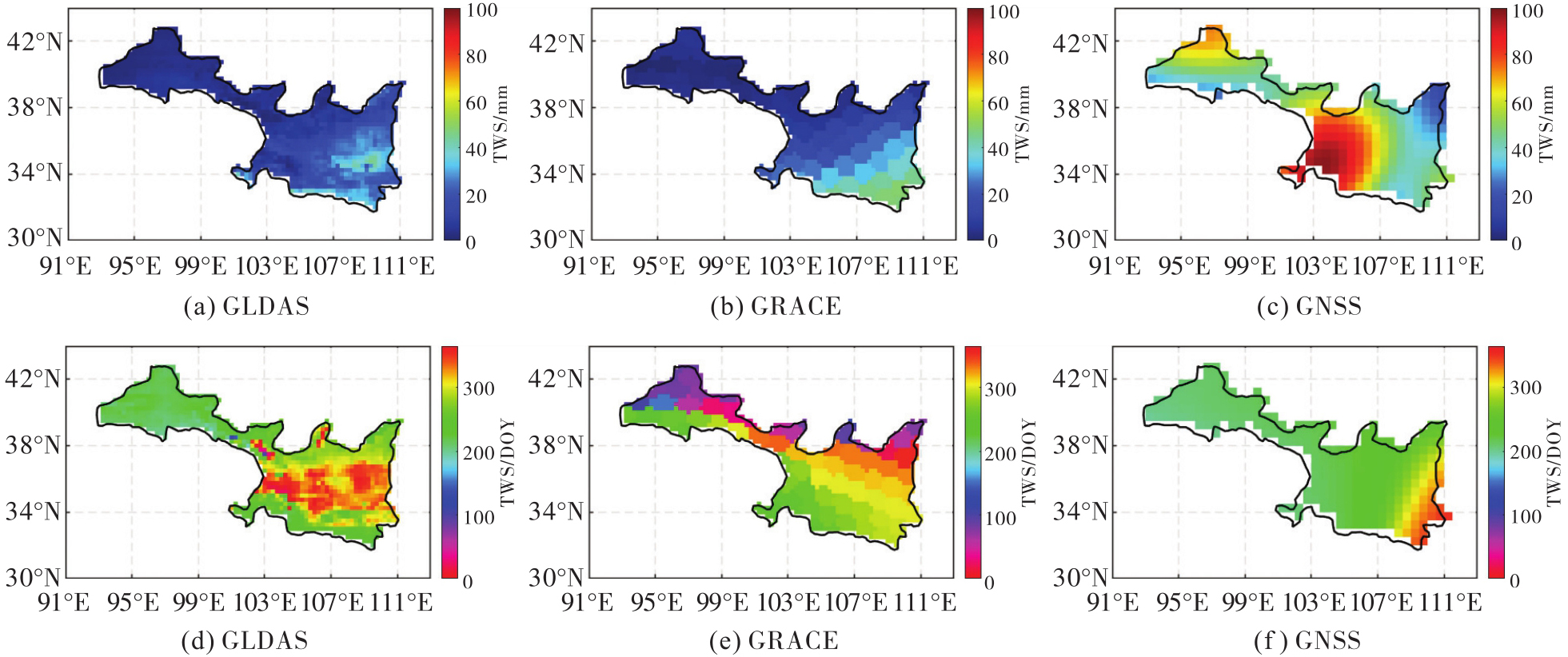
Fig. 4
Time series of GWS changes"
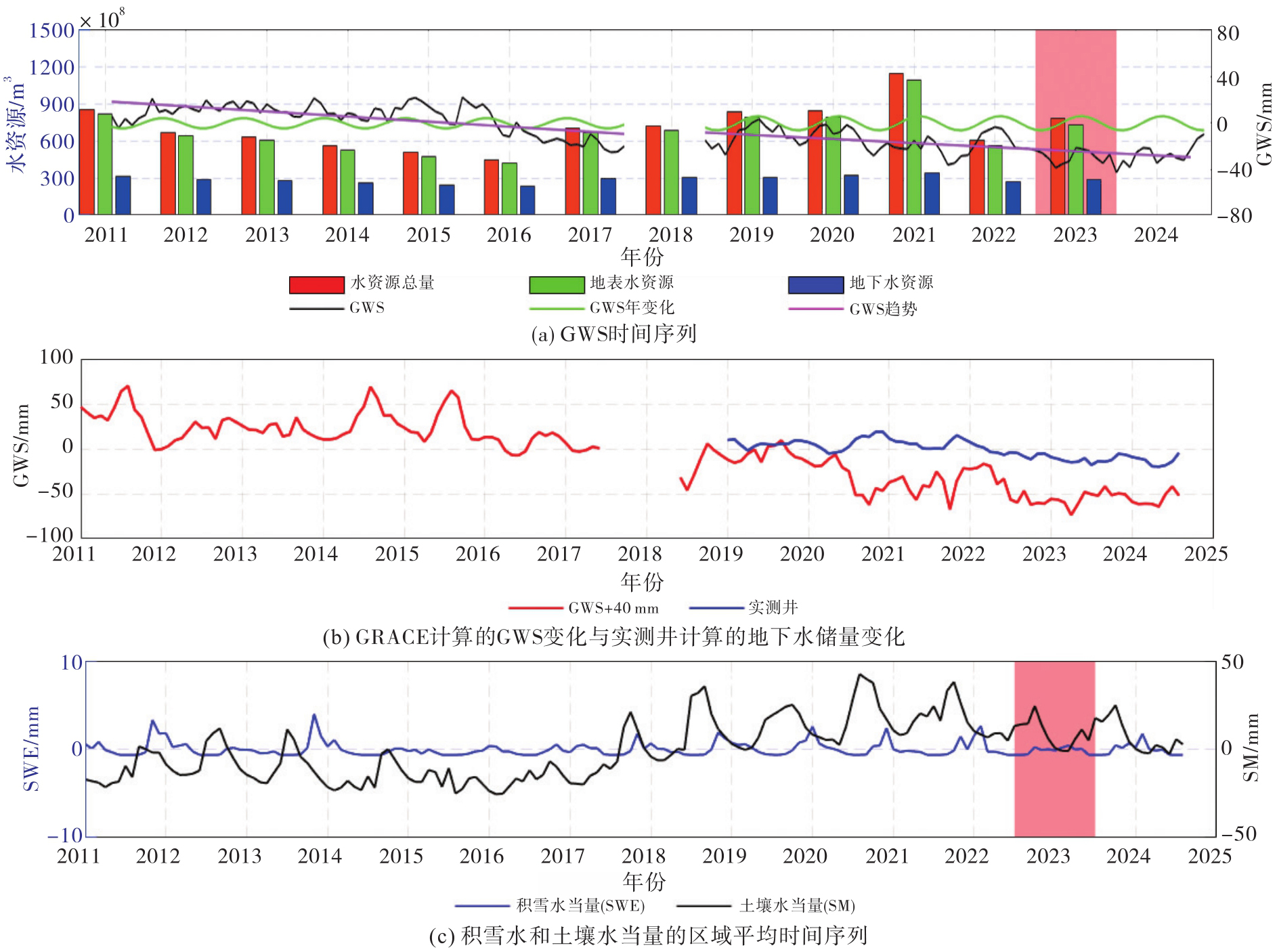
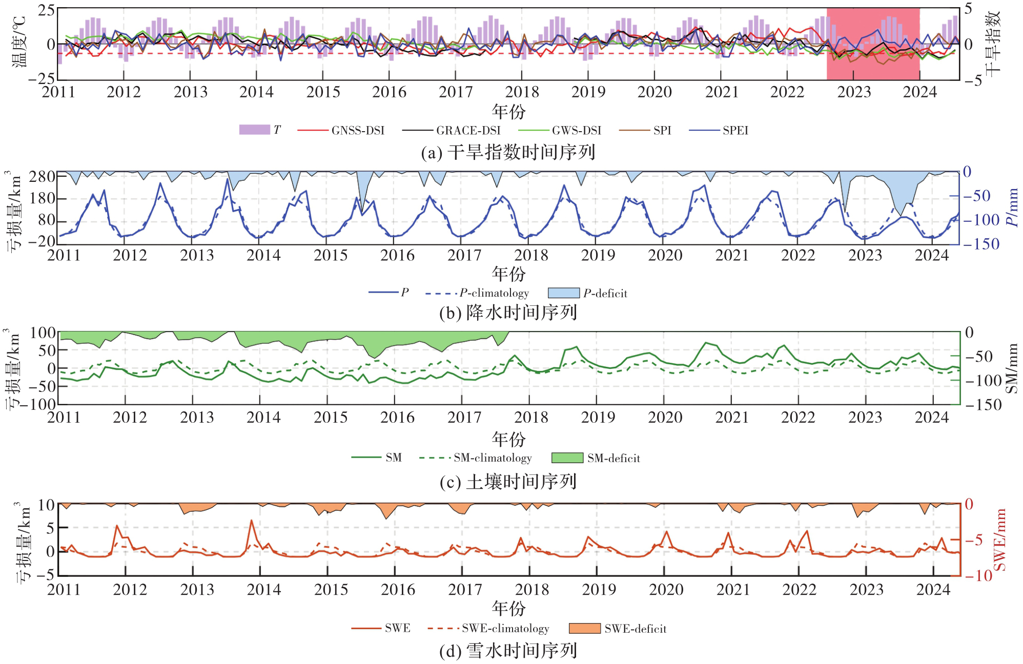
Fig. 5
Hydrological drought index and meteorological hydrological data deficit time series"
Tab. 3
Drought events in the Shaanxi, Gansu and Ningxia region monitored by different drought indices"
| 干旱指数 | 持续时间 | 持续时长 | DSI峰值(峰值年日) | 平均DSI | 主要干旱类型 |
|---|---|---|---|---|---|
| GNSS-DSI | 2011-05—2011-09 | 5个月 | -1.68(2011-07) | -1.08 | D1 |
| 2016-05—2016-10 | 6个月 | -1.36(2016-08) | -0.92 | D1 | |
| 2016-12—2017-02 | 3个月 | -1.32(2017-02) | -1.08 | D1 | |
| 2017-05—2017-08 | 4个月 | -1.47(2017-07) | -0.99 | D1 | |
| 2018-02—2018-06 | 5个月 | -1.77(2018-04) | -1.03 | D1 | |
| 2022-09—2023-06 | 10个月 | -1.73(2022-12) | -1.23 | D1 | |
| 2023-09—2024-05 | 9个月 | -1.66(2023-09) | -1.23 | D1 | |
| GRACE-DSI | 2015-08—2015-12 | 5个月 | -1.75(2015-11) | -1.19 | D1 |
| 2016-02—2017-06 | 17个月 | -1.71(2017-02) | -1.18 | D1 | |
| 2022-09—2023-04 | 8个月 | -1.82(2022-10) | -1.12 | D1 | |
| 2023-07—2024-07 | 13个月 | -2.05(2024-01) | -1.23 | D1 | |
| GWS-DSI | 2016-08—2016-10 | 3个月 | -0.70(2016-09) | -0.66 | D0 |
| 2021-06—2021-11 | 6个月 | -1.55(2021-09) | -0.98 | D1 | |
| 2022-04—2023-05 | 14个月 | -2.09(2022-10) | -1.27 | D1 | |
| 2023-07—2024-08 | 13个月 | -2.16(2024-01) | -1.54 | D2 | |
| SPI | 2011-03—2011-06 | 4个月 | -1.22(2011-05) | -1.01 | D1 |
| 2013-02—2013-04 | 3个月 | -1.22(2013-03) | -1.10 | D1 | |
| 2013-10—2014-01 | 4个月 | -0.91(2013-10) | -0.90 | D1 | |
| 2015-07—2015-09 | 3个月 | -1.22(all time) | -1.22 | D1 | |
| 2022-09—2024-03 | 19个月 | -1.75(2023-10) | -1.52 | D2 | |
| SPEI | 2013-01—2013-04 | 4个月 | -2.10(2013-03) | -1.24 | D1 |
| 2013-08—2013-0 | 3个月 | -1.56(2013-10) | -1.32 | D2 | |
| 2016-11—2016-01 | 3个月 | -0.87(2016-11) | -0.76 | D0 | |
| 2022-05—2022-07 | 3个月 | -1.49(2022-06) | -0.92 | D1 |
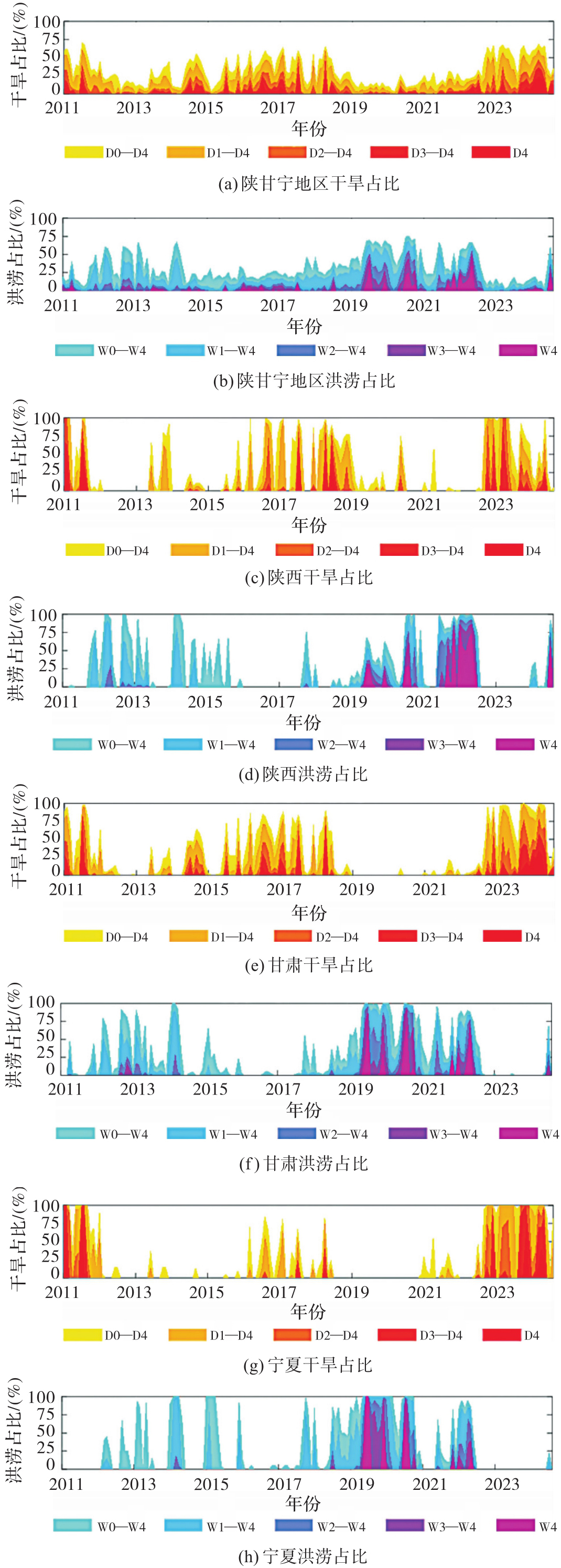
Fig. 6
Proportion of drought areas"
| [1] | LI Shuangshuang, YANG Saini, LIU Xianfeng, et al. NDVI-based analysis on the influence of climate change and human activities on vegetation restoration in the Shaanxi-Gansu-Ningxia Region, Central China[J]. Remote Sensing, 2015, 7(9): 11163-11182. |
| [2] | RODELL M, FAMIGLIETTI J S. Detectability of variations in continental water storage from satellite observations of the time dependent gravity field[J]. Water Resources Research, 1999, 35(9): 2705-2723. |
| [3] | 王林松, 彭桢燃, 谢扬, 等. 利用重力与形变监测陆地水储量的时空响应:数据方法模型与技术应用现状及展望[J]. 地球与行星物理论评(中英文), 2026, 57(2): 129-147. |
| WANG Linsong, PENG Zhenran, XIE Yang, et al. Monitoring the spatiotemporal response of terrestrial water storage using gravity and deformation: current status and prospects for data, methods, models, technologies and applications[J]. Reviews of Geophysics and Planetary Physics, 2026, 57(2): 129-147. | |
| [4] | FARRELL W E. Deformation of the Earth by surface loads[J]. Reviews of Geophysics, 1972, 10(3): 761-797. |
| [5] | BLEWITT G, LAVALLÉE D, CLARKE P, et al. A new global mode of Earth deformation: seasonal cycle detected[J]. Science, 2001, 294(5550): 2342-2345. |
| [6] | TAPLEY B D, BETTADPUR S, RIES J C, et al. GRACE measurements of mass variability in the Earth system[J]. Science, 2004, 305(5683): 503-505. |
| [7] | WHITE A M, GARDNER W P, BORSA A A, et al. A review of GNSS/GPS in hydrogeodesy: hydrologic loading applications and their implications for water resource research[J]. Water Resources Research, 2022, 58(7): e2022WR032078. |
| [8] | FENG Wei. GRAMAT: a comprehensive Matlab toolbox for estimating global mass variations from GRACE satellite data[J]. Earth Science Informatics, 2019, 12(3): 389-404. |
| [9] | WU Xiaoping, HEFLIN M B, IVINS E R, et al. Large-scale global surface mass variations inferred from GPS measurements of load-induced deformation[J]. Geophysical Research Letters, 2003, 30(14): 2003GL017546. |
| [10] | FU Yuning, ARGUS D F, LANDERER F W. GPS as an independent measurement to estimate terrestrial water storage variations in Washington and Oregon[J]. Journal of Geophysical Research: Solid Earth, 2015, 120(1): 552-566. |
| [11] | LI Xianpao, ZHONG Bo, LI Jiancheng, et al. Inversion of GNSS vertical displacements for terrestrial water storage changes using slepian basis functions[J]. Earth and Space Science, 2023, 10(2): e2022EA002608. |
| [12] | ARGUS D F, FU Yuning, LANDERER F W. Seasonal variation in total water storage in California inferred from GPS observations of vertical land motion[J]. Geophysical Research Letters, 2014, 41(6): 1971-1980. |
| [13] | SLEPIAN D. Some comments on Fourier analysis, uncertainty and modeling[J]. SIAM Review, 1983, 25(3): 379-393. |
| [14] | BORSA A A, AGNEW D C, CAYAN D R. Ongoing drought-induced uplift in the western United States[J]. Science, 2014, 345(6204): 1587-1590. |
| [15] | LU Liguo, LUO Xinyu, CHAO Nengfang, et al. Using integrated geodetic data for enhanced monitoring of drought characteristics across four provinces and municipalities in southwest China[J]. Remote Sensing, 2025, 17(3): 397. |
| [16] | CHEN Jianli, TAPLEY B, RODELL M, et al. Basin-scale river runoff estimation from GRACE gravity satellites, climate models, and in situ observations: a case study in the Amazon Basin[J]. Water Resources Research, 2020, 56(10): e2020WR028032. |
| [17] | ZHANG Rui, PENG Yujie, CHAO Nengfang, et al. A rapid increase of groundwater in 2021 over the North China Plain from GPS and GRACE observations[J]. GPS Solutions, 2024, 29(1): 37. |
| [18] | YAN Feng, ZHANG Yuwen, WANG Xinpeng, et al. Characteristics of spatial and temporal non-stationarity of groundwater storage in different basins of China and its driving mechanisms[J]. Journal of Hydrology, 2025, 655: 132882. |
| [19] | LIU Sulan, WU Yunlong, XU Guodong, et al. Revealing the spatio temporal evolution of the 2024 extreme flood in Guangdong province: insights from GRACE-FO and in situ measurements[J]. Journal of Hydrology: Regional Studies, 2025, 59: 102451. |
| [20] | HAN Zhiming, HUANG Shengzhi, HUANG Qiang, et al. Propagation dynamics from meteorological to groundwater drought and their possible influence factors[J]. Journal of Hydrology, 2019, 578: 124102. |
| [21] | LIU Renli, ZHONG Bo, LI Xianpao, et al. Analysis of groundwater changes (2003-2020) in the North China Plain using geodetic measurements[J]. Journal of Hydrology: Regional Studies, 2022, 41: 101085. |
| [22] | ZHONG Bo, LI Xianpao, CHEN Jianli, et al. Surface mass variations from GPS and GRACE/GFO: a case study in southwest China[J]. Remote Sensing, 2020, 12(11): 1835. |
| [23] | YANG Xinghai, YUAN Linguo, TANG Miao, et al. Assessing and attributing flood potential in Brazil using GPS 3D deformation[J]. Remote Sensing of Environment, 2025, 318: 114535. |
| [24] | HERRING T, KING R, MCCLUSKY S. GAMIT reference manual[R]. Massachusetts: Massachusetts Institute of Technology, 2010. |
| [25] | DONG D, HERRING T A, KING R W. Estimating regional deformation from a combination of space and terrestrial geodetic data[J]. Journal of Geodesy, 1998, 72(4): 200-214. |
| [26] | LIU Ning, DAI Wujiao, SANTERRE R, et al. A Matlab-based Kriged Kalman Filter software for interpolating missing data in GNSS coordinate time series[J]. GPS Solutions, 2017, 22(1): 1-8. |
| [27] | DILL R, DOBSLAW H. Numerical simulations of global-scale high-resolution hydrological crustal deformations[J]. Journal of Geophysical Research: Solid Earth, 2013, 118(9): 5008-5017. |
| [28] | WATKINS M M, WIESE D N, YUAN D N, et al. Improved methods for observing Earth's time variable mass distribution with GRACE using spherical cap mascons[J]. Journal of Geophysical Research: Solid Earth, 2015, 120(4): 2648-2671. |
| [29] | RODELL M, HOUSER P R, JAMBOR U, et al. The global land data assimilation system[J]. Bulletin of the American Meteorological Society, 2004, 85(3): 381-394. |
| [30] | 李建成, 李贤炮, 钟波. 利用GNSS地表形变反演区域陆地水储量变化的进展[J]. 武汉大学学报(信息科学版), 2023, 48(11): 1724-1735. |
| LI Jiancheng, LI Xianpao, ZHONG Bo. Review of inverting GNSS surface deformations for regional terrestrial water storage changes[J]. Geomatics and Information Science of Wuhan University, 2023, 48(11): 1724-1735. | |
| [31] | HAN S C, RAZEGHI S M. GPS recovery of daily hydrologic and atmospheric mass variation: a methodology and results from the Australian Continent[J]. Journal of Geophysical Research: Solid Earth, 2017, 122(11): 9328-9343. |
| [32] | 冯伟, 王长青, 穆大鹏, 等. 基于GRACE的空间约束方法监测华北平原地下水储量变化[J]. 地球物理学报, 2017, 60(5): 1630-1642. |
| FENG Wei, WANG Changqing, MU Dapeng, et al. Groundwater storage variations in the North China Plain from GRACE with spatial constraints[J]. Chinese Journal of Geophysics, 2017, 60(5): 1630-1642. | |
| [33] | HARTMANN J, MOOSDORF N. The new global lithological map database GLiM: a representation of rock properties at the Earth surface[J]. Geochemistry, Geophysics, Geosystems, 2012, 13(12): 2012GC004370. |
| [34] | XIE Xiaowei, XU Caijun, WEN Yangmao, et al. Monitoring groundwater storage changes in the Loess Plateau using GRACE satellite gravity data, hydrological models and coal mining data[J]. Remote Sensing, 2018, 10(4): 605. |
| [35] | ZHU Hai, CHEN Kejie, HU Shunqiang, et al. A novel GNSS and precipitation-based integrated drought characterization framework incorporating both meteorological and hydrological indicators[J]. Remote Sensing of Environment, 2024, 311: 114261. |
| [36] | THOMAS A C, REAGER J T, FAMIGLIETTI J S, et al. A GRACE-based water storage deficit approach for hydrological drought characterization[J]. Geophysical Research Letters, 2014, 41(5): 1537-1545. |
| [37] | 吴汤婷, 罗馨语, 超能芳, 等. 基于GNSS垂直位移量化分析新疆干旱特征[J]. 地球物理学报, 2025, 68(8): 3050-3068. |
| WU Tangting, LUO Xinyu, CHAO Nengfang, et al. Quantitative analysis of drought characteristics in Xinjiang based on GNSS vertical displacements[J]. Chinese Journal of Geophysics, 2025, 68(8): 3050-3068. | |
| [38] | ZHAO Zixian, SHI Wei, YANG Yong, et al. The Late Cenozoic crustal shortening in the north-east margin of the Qilian Shan: Evidence from the Fengle Basin, Gansu Province[J]. Geological Journal, 2020, 55(11): 7193-7205. |
| [1] | Wentao HOU, Yun XIAO, Jie CAO, Yukang WANG, Chunting CAO, Han WANG. A downscaling method for gravity satellite derived groundwater storage changes based on a feature-weighted CatBoost model [J]. Acta Geodaetica et Cartographica Sinica, 2026, 55(3): 490-501. |
| [2] | Qingzhi ZHAO, Lulu CHANG, Yibin YAO, Haojie LI. A method for constructing a hydrological drought index integrated with GNSS and meteorological data [J]. Acta Geodaetica et Cartographica Sinica, 2025, 54(7): 1192-1205. |
| [3] | Dongxu LIU, Litang HU, Jianchong SUN, Qi CHENG, Yixuan MA, Xin LIU. Retrieval of groundwater storage anomalies in eastern region of Korla by downscaling GRACE/GRACE-FO data [J]. Acta Geodaetica et Cartographica Sinica, 2024, 53(7): 1265-1277. |
| [4] | Xinghai YANG, Linguo YUAN, Zhongshan JIANG, Miao TANG. Joint inversion of GNSS and GRACE/GRACE-FO data for terrestrial water storage changes in Southwest China [J]. Acta Geodaetica et Cartographica Sinica, 2024, 53(5): 813-822. |
| [5] | QU Wei, JIN Zehui, ZHANG Qin, GAO Yuan, ZHANG Pufang. Drought characteristics of the Yellow River basin from 2002 to 2020 revealed by GRACE and GRACE Follow-On data [J]. Acta Geodaetica et Cartographica Sinica, 2023, 52(5): 714-724. |
| [6] | CHEN Chao, ZOU Rong, CAO Jiaming, LI Yu, LIANG Hong, FANG Zhiwei. Comparative analysis of Green's functions and Slepian basis functions for GNSS inversion of terrestrial water [J]. Acta Geodaetica et Cartographica Sinica, 2023, 52(12): 2066-2077. |
| [7] | ZHANG Lin, SHEN Yunzhong, CHEN Qiujie, WANG Fengwei. Analysis of terrestrial water storage change and its driving factors of Hongliu River region [J]. Acta Geodaetica et Cartographica Sinica, 2022, 51(4): 622-630. |
| [8] | YAO Chaolong, LUO Zhicai, HU Yueming, WANG Changwei, ZHANG Rui, LI Jinming. Detecting droughts in Southwest China from GPS vertical position displacements [J]. Acta Geodaetica et Cartographica Sinica, 2019, 48(5): 547-554. |
| [9] | HE Siyuan, GU Yanchao, FAN Dongming, ZHAO Hongbin, ZHENG Rong. Seasonal Variation of Terrestrial Water Storage in Yunnan Province Inferred from GPS Vertical Observations [J]. Acta Geodaetica et Cartographica Sinica, 2018, 47(3): 332-340. |
| [10] | JIA Lulu, WANG Hansheng, XIANG Longwei. Measuring Terrestrial Water Storage Change Using GRACE, GPS and Absolute Gravity Data in Scandinavia [J]. Acta Geodaetica et Cartographica Sinica, 2017, 46(2): 170-178. |
| Viewed | ||||||
|
Full text |
|
|||||
|
Abstract |
|
|||||