

Acta Geodaetica et Cartographica Sinica ›› 2026, Vol. 55 ›› Issue (7): 1212-1228.doi: 10.11947/j.AGCS.2026.20260094
• Geodesy and Navigation • Previous Articles
Jun Li( ), Huizhong Zhu(), Bo Li, Yangyang Lu, Zijia Wang, Zhiqiang Liu
Received:2026-03-19
Revised:2026-06-29
Published:2026-08-18
Contact:
Huizhong Zhu
E-mail:lijun_ch@lntu.edu.cn;zhuhuizhong@lntu.edu.cn
About author:Li Jun (1994—), male, PhD, lecturer, majors in GNSS ground-based enhanced positioning algorithm. E-mail: lijun_ch@lntu.edu.cn
Supported by:CLC Number:
Jun Li, Huizhong Zhu, Bo Li, Yangyang Lu, Zijia Wang, Zhiqiang Liu. Reference station position moving method for high-precision positioning and orbit determination[J]. Acta Geodaetica et Cartographica Sinica, 2026, 55(7): 1212-1228.
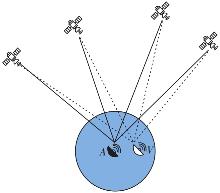
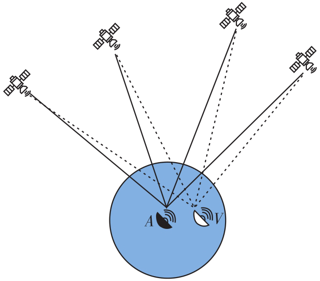
Fig. 1
The moving observations generation"

Tab. 1
The errors comparison between the move reference station and the real reference station"
| 参考站类型 | 接收机端误差 | 卫星端误差 | 大气延迟误差 |
|---|---|---|---|
| 实际参考站 | 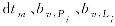 |  |  |
| 偏置参考站 | 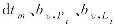 |  |  |
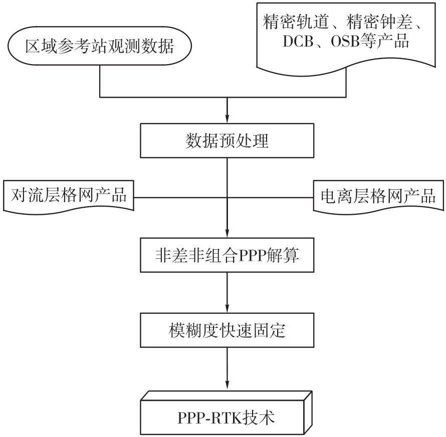
Fig. 2
PPP-RTK technology flow"
Tab. 2
Precision orbit determination observation model"
| 参数 | 描述 |
|---|---|
| 观测量 | 非差无电离层组合 |
| 估计器 | 最小二乘 |
| 卫星系统 | BDS-3、GPS、Galileo |
| 观测值权 | 高度角定权 |
| 截止高度角 | 7° |
| 卫星钟差 | 历元白噪声进行估计 |
| 卫星天线相位中心改正 | GPS:M14.ATX改正PCO/PCV |
| BDS:M14.ATX仅改正PCO | |
| 对流层延迟 | SAAS+GMF投影 |
| 接收机钟差 | 过程估计+白噪声 |
| 系统间延迟 | 按常数估计 |
| 模糊度 | 固定解 |
Tab. 3
Precise orbit determination dynamics model"
| 模型 | 处理策略 |
|---|---|
| 轨道积分 | RKF+Adams |
| 卫星姿态 | 名义姿态 |
| 天线推力 | 改正 |
| 地球反照辐射 | 改正 |
| 太阳光压 | GPS:ECOM1光压模型 |
| BDS:ECOM2+EMP光压模型 | |
| Galileo:ECOM1+BW模型 | |
| 潮汐 | 固体潮、海潮和极潮 |
| N体引力 | 太阳、月亮和其他行星 |
| 地球重力场 | 12阶次EGM |
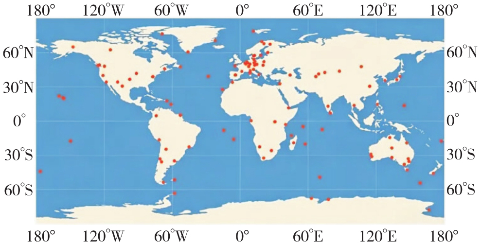
Fig. 3
Global station distribution"
Tab. 4
Position moving distance of reference station"
| 偏置 | 最大距离 | 最小距离 | 中位数 | 平均值 |
|---|---|---|---|---|
| 距离/m | 887.75 | 68.30 | 414.19 | 430.32 |
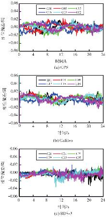
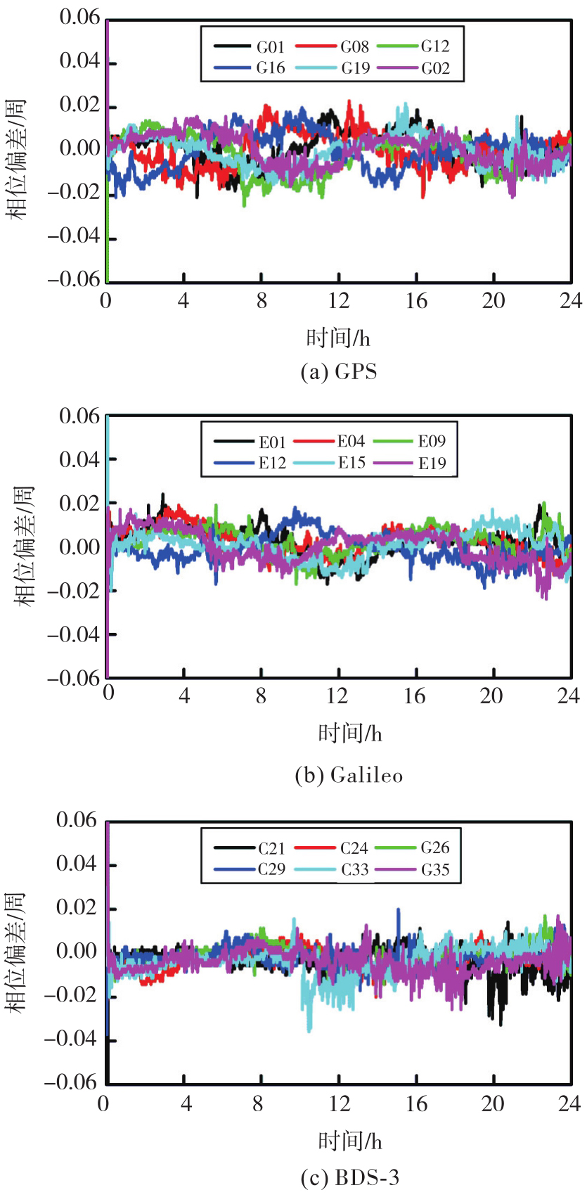
Fig. 4
Reference station position moving difference sequence of NL-UPD"
Tab. 5
The influence of position moving on NL-UPD"
| 卫星 | 偏置前/周 | 偏置后/周 | 差异/周 |
|---|---|---|---|
| GPS | 0.018 1 | 0.018 3 | 0.002 |
| Galileo | 0.018 1 | 0.019 0 | 0.009 |
| BDS-3 | 0.038 5 | 0.038 3 | 0.002 |
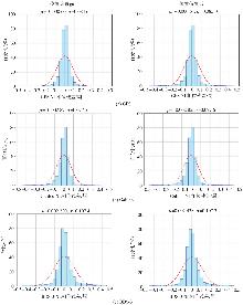
Fig. 5
The influence of reference station position moving on the residual errors of NL-UPD"

Tab. 6
The influence of position moving on the residual error of NL-UPD"
| 卫星 | [-0.10,0.10]周 | [-0.15,0.15]周 | ||
|---|---|---|---|---|
| 偏置前 | 偏置后 | 偏置前 | 偏置后 | |
| GPS | 88.83 | 88.70 | 93.25 | 93.17 |
| Galileo | 90.09 | 90.12 | 94.34 | 94.30 |
| BDS-3 | 82.46 | 82.43 | 88.86 | 88.82 |
Tab. 7
Statistics of the influence of reference station position moving on PPP"
| 测站 | 偏置距离/m | E/mm | N/mm | U/mm | 收敛时间/s |
|---|---|---|---|---|---|
| ABPO | 525 | 0.5 | 0.3 | 0 | 0 |
| ALIC | 431 | 0.6 | 0.4 | 0.7 | 30 |
| AMC4 | 807 | 0.7 | 0.1 | 0.4 | 0 |
| AREG | 440 | 0.9 | 0.1 | 0.2 | 30 |
| ARHT | 261 | 0 | 0 | 0.3 | 0 |
| ARUC | 400 | 0.3 | 0.1 | 0.5 | 30 |
| ASCG | 447 | 0.5 | 0.1 | 0.2 | 0 |
| BAMF | 381 | 0.5 | 0 | 0.2 | 0 |
| BOGT | 538 | 0.4 | 0.3 | 0.1 | 0 |
| BREW | 76 | 0 | 0.1 | 0 | 0 |
| BRST | 382 | 0 | 0.1 | 0.1 | 0 |
| BRUX | 679 | 0.1 | 0.5 | 0.8 | 30 |
| BSHM | 748 | 0.1 | 0.1 | 0.6 | 0 |
| CEBR | 800 | 0.9 | 0.1 | 0.2 | 60 |
| CEDU | 83 | 0 | 0 | 0.1 | 0 |
| 均值 | 466 | 0.36 | 0.15 | 0.29 | 12 |
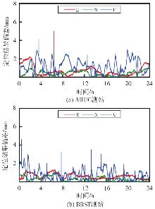
Fig. 6
Position difference between ARUC station and BRST station"
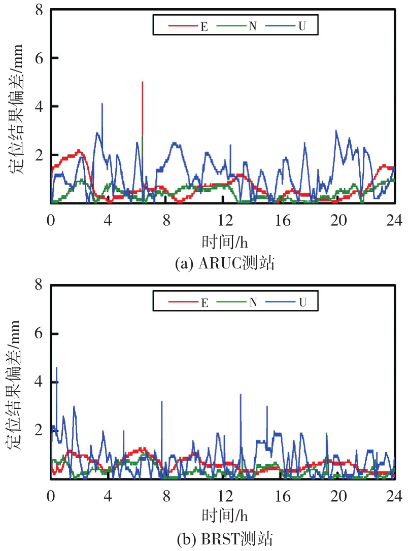
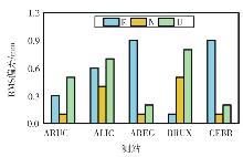
Fig. 7
The influence of reference station position moving on positioning results"
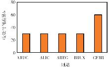
Fig. 8
The influence of reference station position moving on convergence time"
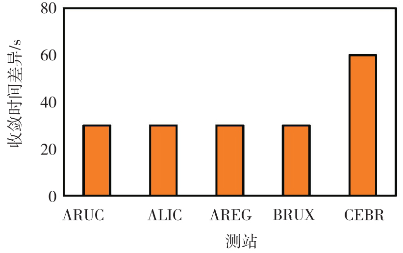
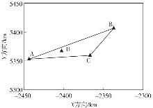
Fig. 9
Distribution of stations"
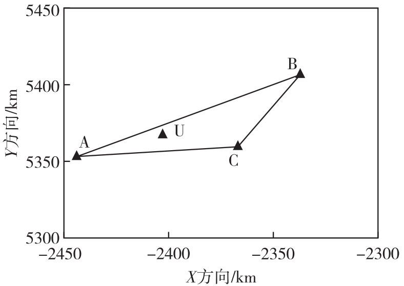
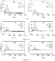
Fig. 10
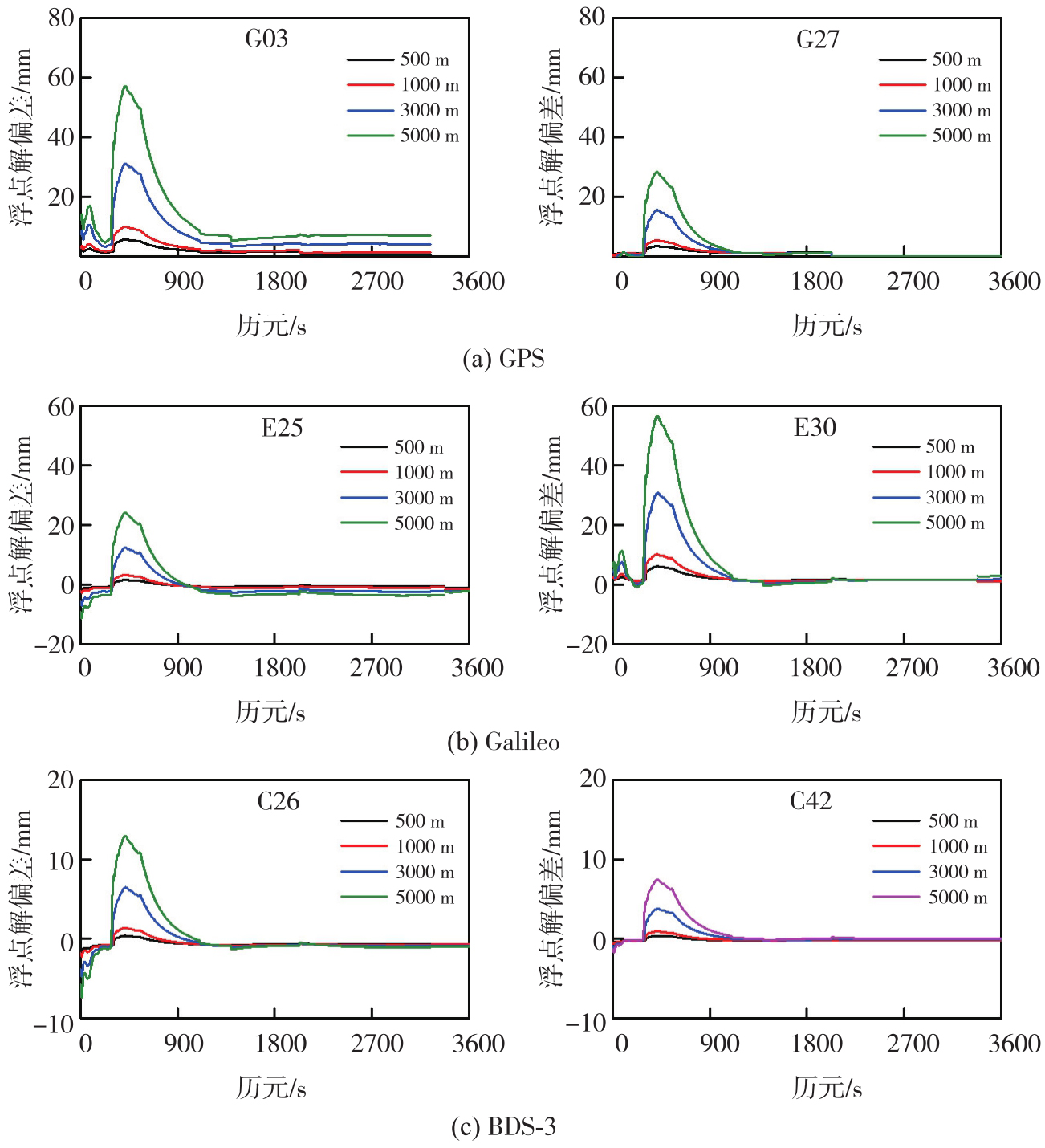
Variation of floating ambiguity difference with time at different moving distances"
Tab. 8
Variation of RMS of ambiguity float solution"
| 卫星 | RMS | |||||
|---|---|---|---|---|---|---|
| 100 m | 500 m | 1000 m | 2000 m | 3000 m | 5000 m | |
| G03 | 1.58 | 2.21 | 3.60 | 6.21 | 10.44 | 18.70 |
| G27 | 0.94 | 1.34 | 1.77 | 2.67 | 4.34 | 7.77 |
| E25 | 0.36 | 0.72 | 1.25 | 2.35 | 3.83 | 7.11 |
| E30 | 1.85 | 2.36 | 3.26 | 5.97 | 8.69 | 15.77 |
| C26 | 0.29 | 0.67 | 0.79 | 1.23 | 1.94 | 3.66 |
| C42 | 0.06 | 0.19 | 0.29 | 0.87 | 1.04 | 2.04 |
Fig. 11
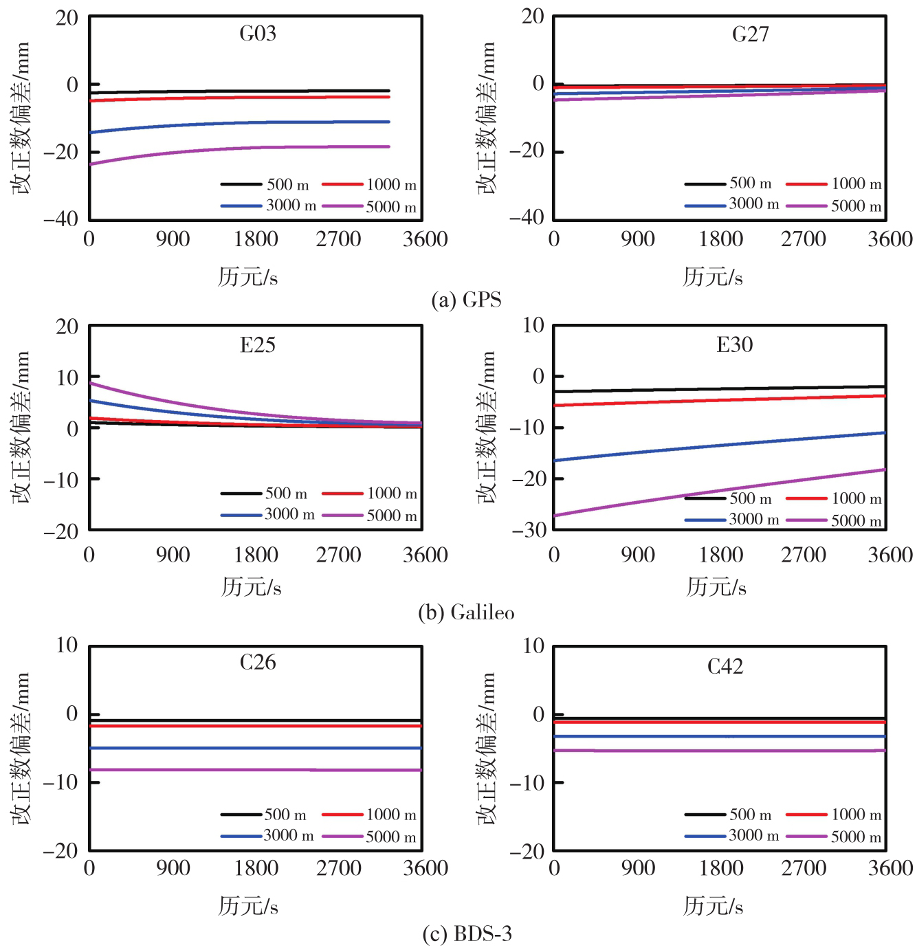
The variation of errors correction number at differents moving distances of reference station"
Tab. 9
Variation of RMS of undifferenced error correction"
| 卫星 | RMS | |||||
|---|---|---|---|---|---|---|
| 100 m | 500 m | 1000 m | 2000 m | 3000 m | 5000 m | |
| G03 | 1.19 | 2.13 | 4.08 | 7.54 | 11.85 | 19.61 |
| G27 | 0.16 | 0.39 | 0.71 | 1.32 | 2.01 | 3.31 |
| E25 | 0.14 | 0.39 | 0.72 | 1.35 | 2.04 | 3.36 |
| E30 | 1.21 | 2.43 | 4.62 | 7.93 | 13.37 | 22.12 |
| C26 | 0.43 | 0.89 | 1.70 | 3.45 | 4.92 | 8.13 |
| C42 | 0.35 | 0.59 | 1.12 | 2.47 | 3.22 | 5.32 |
Fig. 12
User position of different moving distances of reference station"
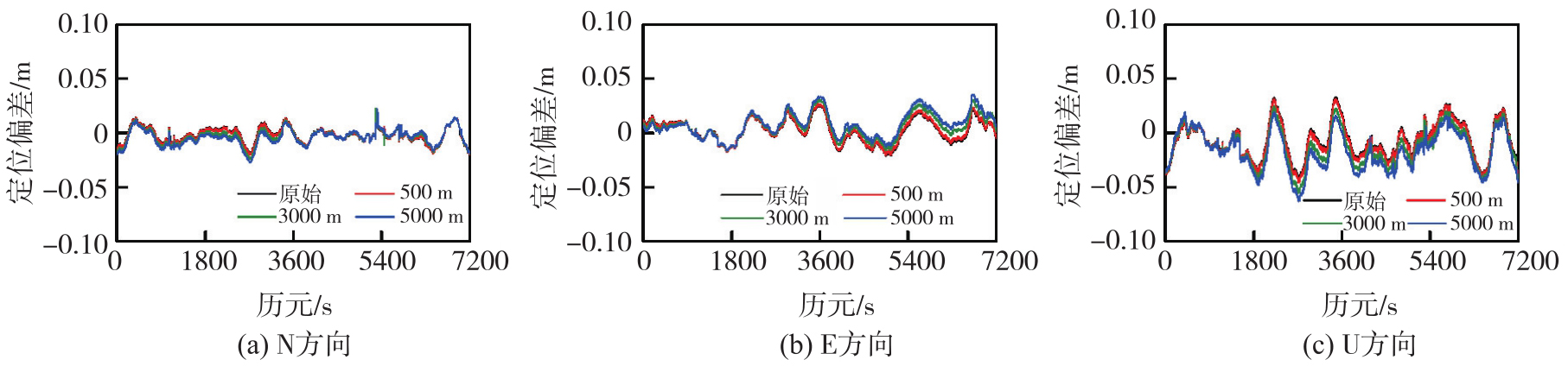
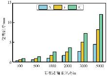
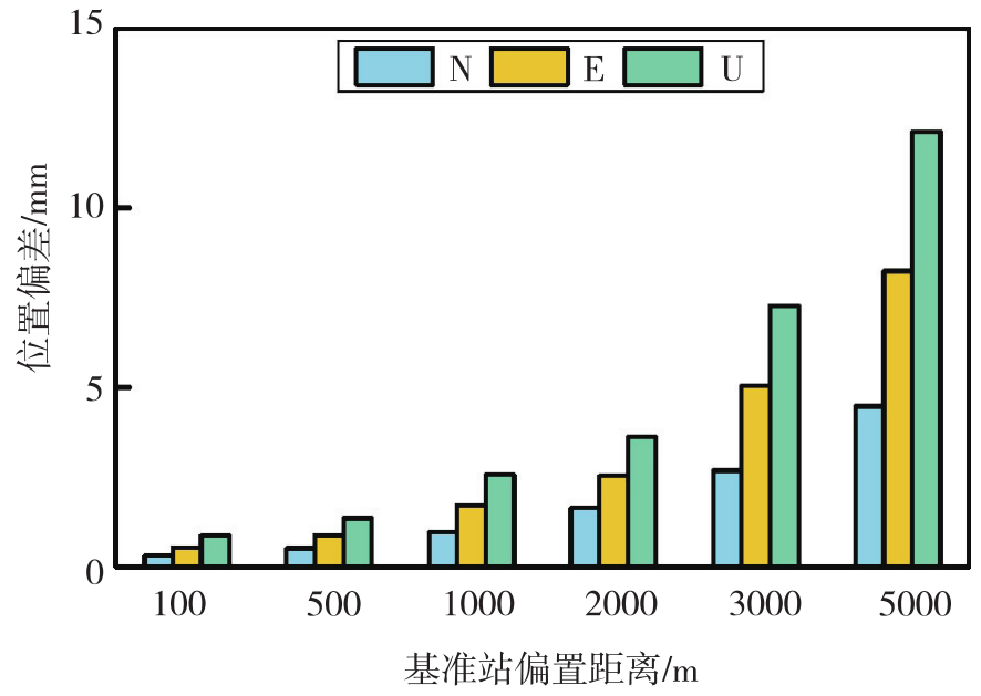
Fig. 13
RMS of user positioning accuracy errors for different moving distances of reference stations"
Tab. 10
Variation of positioning difference of user stations"
| RMS | N/mm | E/mm | U/mm | 收敛速度差异/s |
|---|---|---|---|---|
| 100 m | 0.31 | 0.54 | 0.87 | 0 |
| 500 m | 0.52 | 0.89 | 1.36 | 0 |
| 1 000 m | 0.96 | 1.71 | 2.57 | 1 |
| 2 000 m | 1.64 | 2.53 | 3.61 | 1 |
| 3 000 m | 2.68 | 5.04 | 7.28 | 1 |
| 5 000 m | 4.46 | 8.25 | 12.12 | 2 |
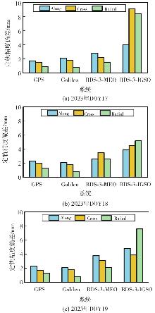
Fig. 14
Orbit determination errors statistics"
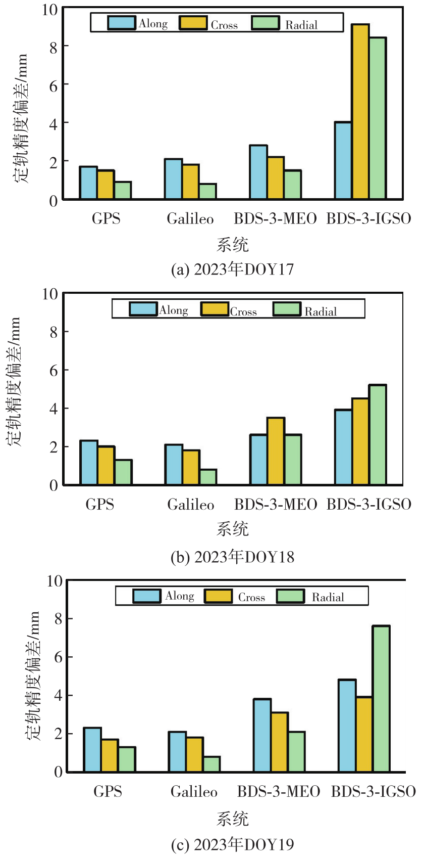
Tab. 11
Statistical values of the influence of reference station position moving on orbit determination accuracy"
| 日期 | 系统 | 3D-mean | Along | Cross | Radial |
|---|---|---|---|---|---|
| 2023年DOY17 | GPS | 1.4 | 1.7 | 1.5 | 0.9 |
| Galileo | 1.9 | 2.1 | 1.8 | 0.8 | |
| BDS-3-MEO | 2.3 | 2.8 | 2.2 | 1.5 | |
| BDS-3-IGSO | 7.7 | 4.0 | 9.1 | 8.4 | |
| 2023年DOY18 | GPS | 2.0 | 2.3 | 2.0 | 1.3 |
| Galileo | 1.9 | 2.1 | 1.8 | 0.8 | |
| BDS-3-MEO | 4.3 | 2.6 | 3.5 | 2.6 | |
| BDS-3-IGSO | 4.8 | 3.9 | 4.5 | 5.2 | |
| 2023年DOY19 | GPS | 1.9 | 2.3 | 1.7 | 1.3 |
| Galileo | 1.9 | 2.1 | 1.8 | 0.8 | |
| BDS-3-MEO | 3.2 | 3.8 | 3.1 | 2.1 | |
| BDS-3-IGSO | 5.7 | 4.8 | 3.9 | 7.6 |
| [1] | 刘经南, 刘晖. 建立我国卫星定位连续运行站网的若干思考[J]. 武汉大学学报(信息科学版), 2003, 28(S1): 27-31. |
| Liu Jingnan, Liu Hui. Thought on establishing a continuous operational reference station network in China[J]. Geomatics and Information Science of Wuhan University, 2003, 28(S1): 27-31. | |
| [2] | 李健, 吕志平, 乔书波. 连续运行参考站网的演化与发展趋势[J]. 测绘科学, 2008, 33(S1): 44-46. |
| Li Jian, Lü Zhiping, Qiao Shubo. Concept, evolvement and tendency of CORS[J]. Science of Surveying and Mapping, 2008, 33(S1): 44-46. | |
| [3] |
姜卫平. 卫星导航定位基准站网的发展现状、机遇与挑战[J]. 测绘学报, 2017, 46(10): 1379-1388. DOI: .
doi: 10.11947/j.AGCS.2017.20170424 |
|
Jiang Weiping. Challenges and opportunities of GNSS reference station network[J]. Acta Geodaetica et Cartographica Sinica, 2017, 46(10): 1379-1388. DOI: .
doi: 10.11947/j.AGCS.2017.20170424 |
|
| [4] |
沈飞. 采用非差模型的区域连续运行参考站网地学应用方法研究[J]. 测绘学报, 2020, 49(8): 1072. DOI: .
doi: 10.11947/j.AGCS.2020.20200152 |
|
Shen Fei. Research on regional CORS applications in geoscience using undifferenced precise point positioning[J]. Acta Geodaetica et Cartographica Sinica, 2020, 49(8): 1072. DOI: .
doi: 10.11947/j.AGCS.2020.20200152 |
|
| [5] | Tang Weiming, Liu Wenjian, Zou Xuan, et al. Improved ambiguity resolution for URTK with dynamic atmosphere constraints[J]. Journal of Geodesy, 2016, 90(12): 1359-1369. |
| [6] | Zou Xuan, Wang Yawei, Deng Chenlong, et al. Instantaneous BDS+GPS undifferenced NRTK positioning with dynamic atmospheric constraints[J]. GPS Solutions, 2017, 22(1): 17. |
| [7] | Odijk D, Zhang Baocheng, Khodabandeh A, et al. On the estimability of parameters in undifferenced, uncombined GNSS network and PPP-RTK user models by means of S-system theory[J]. Journal of Geodesy, 2016, 90(1): 15-44. |
| [8] | Li Zhao, Chen Wu, Ruan Rengui, et al. Evaluation of PPP-RTK based on BDS-3/BDS-2/GPS observations: a case study in Europe[J]. GPS Solutions, 2020, 24(2): 38. |
| [9] | Zhang Baocheng, Chen Yongchang, Yuan Yunbin. PPP-RTK based on undifferenced and uncombined observations: theoretical and practical aspects[J]. Journal of Geodesy, 2019, 93(7): 1011-1024. |
| [10] | 朱威, 任晓东, 张小红. 不同纬度和站间距的电离层单星模型对PPP-RTK增强定位效果分析[J]. 武汉大学学报(信息科学版), 2025, 50(11): 2381-2390. |
| Zhu Wei, Ren Xiaodong, Zhang Xiaohong. Performance of PPP-RTK enhanced by slant ionospheric model based on reference stations with different latitudes and distances[J]. Geomatics and Information Science of Wuhan University, 2025, 50(11): 2381-2390. | |
| [11] | 自然资源部. 自然资源部举行12月份例行新闻发布会[EB/OL]. (2025-12-30) [2026-04-26]. http://www.scio.gov.cn/xwfb/bwxwfb/gbwfbh/zrzyb/202601/t20260104_944629.html. |
| Ministry of Natural Resources of China. The Ministry of Natural Resources held a regular press conference in December[EB/OL]. (2025-12-30) [2026-04-26]. http://www.scio.gov.cn/xwfb/bwxwfb/gbwfbh/zrzyb/202601/t20260104_944629.html. | |
| [12] | 徐彦田, 窦世标, 刘艳辉, 等. 我国GNSS基准站空间分布特征分析[J]. 测绘科学, 2023, 48(6): 33-37, 72. |
| Xu Yantian, Dou Shibiao, Liu Yanhui, et al. Study on the spatial distribution characteristics of GNSS reference station in China[J]. Science of Surveying and Mapping, 2023, 48(6): 33-37, 72. | |
| [13] | 国家市场监督管理总局, 国家标准化管理委员会. GB/T 44977—2024 卫星导航定位基准站网终端定位服务安全技术规范[S]. 北京: 中国标准出版社, 2024. |
| State Administration for Market Regulation, Standardization Administration of China. GB/T 44977—2024 Specification for security of positioning service terminal of reference stations using global navigation satellite system[S]. Beijing: Standards Press of China, 2024. | |
| [14] | Brandl M, Chen X M, Landau H, et al. Anatomy of a centimeter-level precise point positioning service[J]. GPS World, 2019, 30(5): 28-35. |
| [15] | 张伟, 王林. 城市CORS系统加密转换参数的研究与应用[J]. 全球定位系统, 2022, 47(3): 46-50. |
| Zhang Wei, Wang Lin. Research and application of encryption conversion parameters in urban CORS system[J]. GNSS World of China, 2022, 47(3): 46-50. | |
| [16] | 程鹏飞, 蔡艳辉, 徐彦田. 一种GNSS原始观测数据变换方法: CN201710369236.6[P]. 2018-06-15. |
| Cheng Pengfei, Cai Yanhui, Xu Yantian. A GNSS original observation data transformation method: CN201710369236.6[P]. 2018-06-15. | |
| [17] | 姜益昊, 陶钧, 杨超, 等. GNSS基准站原始观测数据的一种虚拟化算法[J]. 测绘地理信息, 2020, 45(5): 29-34. |
| Jiang Yihao, Tao Jun, Yang Chao, et al. A virtualization algorithm for raw observation data of GNSS base station[J]. Journal of Geomatics, 2020, 45(5): 29-34. | |
| [18] | 石波, 王云鹏, 李太恒. 基准站观测数据加密方法及其在差分GNSS后处理中的应用[J]. 武汉大学学报(信息科学版), 2018, 43(5): 651-657. |
| Shi Bo, Wang Yunpeng, Li Taiheng. A densification method for base station observation data and its application to post processing of differential GNSS[J]. Geomatics and Information Science of Wuhan University, 2018, 43(5): 651-657. | |
| [19] | Wanninger L. Virtual reference stations (VRS)[J]. GPS Solutions, 2003, 7(2): 143-144. |
| [20] |
黄丁发, 冯威, 李剑锋, 等. 高精度实时位置服务的格网化VRS技术[J]. 测绘学报, 2022, 51(8): 1717-1724. DOI: .
doi: 10.11947/j.AGCS.2022.20210435 |
|
Huang Dingfa, Feng Wei, Li Jianfeng, et al. Grid VRS technique of real time high-precision location-based service[J]. Acta Geodaetica et Cartographica Sinica, 2022, 51(8): 1717-1724. DOI: .
doi: 10.11947/j.AGCS.2022.20210435 |
|
| [21] |
周锋, 徐天河. GPS/BDS/Galileo三频精密单点定位模型及性能分析[J]. 测绘学报, 2021, 50(1): 61-70. DOI: .
doi: 10.11947/J.AGCS.2021.20200146 |
|
Zhou Feng, Xu Tianhe. Modeling and assessment of GPS/BDS/Galileo triple-frequency precise point positioning[J]. Acta Geodaetica et Cartographica Sinica, 2021, 50(1): 61-70. DOI: .
doi: 10.11947/J.AGCS.2021.20200146 |
|
| [22] |
李军, 祝会忠, 刘智强. 北斗长距离参考站网模糊度固定中电离层参数的优化方法[J]. 测绘学报, 2025, 54(2): 221-232. DOI: .
doi: 10.11947/j.AGCS.2025.20240270 |
|
Li Jun, Zhu Huizhong, Liu Zhiqiang. An optimization method for ionospheric parameters in ambiguity resolution of BDS long-range reference station network[J]. Acta Geodaetica et Cartographica Sinica, 2025, 54(2): 221-232. DOI: .
doi: 10.11947/j.AGCS.2025.20240270 |
|
| [23] | 祝会忠, 郑人维, 张凯, 等. BDS/GPS非差误差改正数的实时动态定位方法[J]. 测绘科学, 2021, 46(1): 15-23. |
| Zhu Huizhong, Zheng Renwei, Zhang Kai, et al. The method of BDS/GPS real time kinematic non-difference error correction[J]. Science of Surveying and Mapping, 2021, 46(1): 15-23. | |
| [24] | 黄丁发, 李成钢, 吴耀强, 等. GPS/VRS实时网络改正数生成算法研究[J]. 测绘学报, 2007, 36(3): 256-261, 339. |
| Huang Dingfa, Li Chenggang, Wu Yaoqiang, et al. Study of the real-time network correction generation approach for GPS/VRS technique[J]. Acta Geodaetica et Cartographica Sinica, 2007, 36(3): 256-261, 339. | |
| [25] | 姚长虹. GPS卫星位置解算算法研究[J]. 科学技术与工程, 2010, 10(8): 1915-1918. |
| Yao Changhong. Research on GPS position calculation arithmetic[J]. Science Technology and Engineering, 2010, 10(8): 1915-1918. | |
| [26] | Schaffrin B, Bock Y. A unified scheme for processing GPS dual-band phase observations[J]. Bulletin Géodésique, 1988, 62(2): 142-160. |
| [27] | Li Jun, Zhu Huizhong, Xu Aigong, et al. Estimating ionospheric power spectral density for long-range RTK positioning using uncombined observations[J]. GPS Solutions, 2023, 27(3): 109. |
| [28] | Jiang Chunhua, Chen Shaoni, Wang Shuaimin, et al. A grid model of direct conversion between zenith tropospheric delay and precipitable water vapor in tropical regions[J]. GPS Solutions, 2024, 28(3): 127. |
| [29] | Niell A E. Global mapping functions for the atmosphere delay at radio wavelengths[J]. Journal of Geophysical Research: Solid Earth, 1996, 101(B2): 3227-3246. |
| [30] | Boehm J, Niell A, Tregoning P, et al. Global mapping function (GMF): a new empirical mapping function based on numerical weather model data[J]. Geophysical Research Letters, 2006, 33(7): 304-307. |
| [31] | Saastamoinen J H. Atmospheric correction for the troposphere and the stratosphere in radio ranging satellites[M]//The use of artificial satellites for geodesy. Washington, D. C.: American Geophysical Union, 1972, 247-251. |
| [32] | 葛茂荣, 刘经南. GPS定位中对流层折射估计研究[J]. 测绘学报, 1996, 25(4): 285-291. |
| Ge Maorong, Liu Jingnan. The estimation methods for tropospheric delays in global positioning system[J]. Acta Geodaetica et Cartographica Sinica, 1996, 25(4): 285-291. | |
| [33] | Verhagen S, Li Bofeng, Teunissen P J G. Ps-LAMBDA: ambiguity success rate evaluation software for interferometric applications[J]. Computers & Geosciences, 2013, 54: 361-376. |
| [34] |
祝会忠. 基于非差误差改正数的长距离单历元GNSS网络RTK算法研究[J]. 测绘学报, 2015, 44(1): 116. DOI: .
doi: 10.11947/j.AGCS.2015.20140358 |
|
Zhu Huizhong. The study of GNSS network RTK algorithm between long range at single epoch using un-difference error corrections[J]. Acta Geodaetica et Cartographica Sinica, 2015, 44(1): 116. DOI: .
doi: 10.11947/j.AGCS.2015.20140358 |
|
| [35] | 唐卫明, 刘经南, 刘晖, 等. 一种GNSS网络RTK改进的综合误差内插方法[J]. 武汉大学学报(信息科学版), 2007, 32(12): 1156-1159. |
| Tang Weiming, Liu Jingnan, Liu Hui, et al. A modified combined bias interpolation method for GNSS network RTK[J]. Geomatics and Information Science of Wuhan University, 2007, 32(12): 1156-1159. | |
| [36] | 赵齐乐, 刘经南, 葛茂荣, 等. 用PANDA对GPS和CHAMP卫星精密定轨[J]. 大地测量与地球动力学, 2005, 25(2): 113-116, 122. |
| Zhao Qile, Liu Jingnan, Ge Maorong, et al. Precise orbit determination of GPS and champ satellites with panda software[J]. Journal of Geodesy and Geodynamics, 2005, 25(2): 113-116, 122. | |
| [37] | 施闯, 赵齐乐, 楼益栋, 等. 卫星导航系统综合分析处理软件PANDA及研究进展[J]. 航天器工程, 2009, 18(4): 64-70. |
| Shi Chuang, Zhao Qile, Lou Yidong, et al. PANDA: comprehensive processing software for satellite navigation systems and its research progress[J]. Spacecraft Engineering, 2009, 18(4): 64-70. |
| [1] | SHU Bao, LIU Hui, WANG Li, ZHANG Qin, HUANG Guanwen. PPP and RTK integrated service method and performance based on regional reference station network [J]. Acta Geodaetica et Cartographica Sinica, 2022, 51(9): 1870-1880. |
| [2] | HUANG Dingfa, FENG Wei, LI Jianfeng, GONG Xiaoying, LI Shuaishuai. Grid VRS technique of real time high-precision location-based service [J]. Acta Geodaetica et Cartographica Sinica, 2022, 51(8): 1717-1724. |
| [3] | WANG Duo, HUANG Guanwen, DU Yuan, BAI Zhengwei, CHEN Zi, LI Yang. Switching method of GNSS landslide monitoring reference station considering the correction of motion state [J]. Acta Geodaetica et Cartographica Sinica, 2022, 51(10): 2117-2124. |
| [4] | ZHU Huizhong, LI Jun, YU Zeran, ZHANG Kai, XU Aigong. The algorithm of multi-frequency carrier phase integer ambiguity resolution with GPS/BDS between long range network RTK reference stations [J]. Acta Geodaetica et Cartographica Sinica, 2020, 49(3): 300-311. |
| [5] | ZHU Huizhong, LEI Xiaoting, LI Jun, GAO Meng, XU Aigong. The algorithm of integer ambiguity resolution with BDS triple-frequency between reference stations at single epoch [J]. Acta Geodaetica et Cartographica Sinica, 2020, 49(11): 1388-1398. |
| [6] | CHEN Ming, GUO Jiming, WU Junli, SONG Weiwei, ZHANG Longping. Accuracy Assessment of BDS Precision Orbit Determination and the Influence Analysis of Site Distribution [J]. Acta Geodaetica et Cartographica Sinica, 2018, 47(S0): 93-100. |
| [7] | JIANG Weiping. Challenges and Opportunities of GNSS Reference Station Network [J]. Acta Geodaetica et Cartographica Sinica, 2017, 46(10): 1379-1388. |
| [8] | . Precise Point Positioning Based on Reference Stations Augmentation Information [J]. Acta Geodaetica et Cartographica Sinica, 2014, 43(5): 481-485. |
| [9] | . Noise Model Establishment of IGS Reference Station Time Series inside China and its Analysis [J]. Acta Geodaetica et Cartographica Sinica, 2012, 41(4): 0-590. |
| [10] | . Extracting Precise Atmospheric Propaganda Delays from Multiple Reference Station GPS Networks [J]. Acta Geodaetica et Cartographica Sinica, 2012, 41(4): 0-590. |
| Viewed | ||||||
|
Full text |
|
|||||
|
Abstract |
|
|||||
