
Acta Geodaetica et Cartographica Sinica ›› 2026, Vol. 55 ›› Issue (9): 1612-1629.doi: 10.11947/j.AGCS.2026.20260129
• Photogrammetry and Remote Sensing • Previous Articles Next Articles
Shuhan Jia( ), Yuxiang Feng, Quanhua Zhao, Yu Li
Received:2026-04-07
Revised:2026-09-16
Online:2026-10-28
Published:2026-10-28
About author:Jia Shuhan (1995—), female, PhD, lecturer, majors in remote sensing image information recognition and extraction. E-mail: jiashlzh@163.com
Supported by:CLC Number:
Shuhan Jia, Yuxiang Feng, Quanhua Zhao, Yu Li. Cultivated land extraction in mountainous and hilly areas based on MSFE-OCNet algorithm[J]. Acta Geodaetica et Cartographica Sinica, 2026, 55(9): 1612-1629.
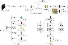
Fig. 1
Network architecture of the MSFE-OCNet algorithm"

Tab. 1
Branch details for the ASPP modules"
| 分支 | 核心操作 | 空洞率 | 作用 | 输出特征特点 |
|---|---|---|---|---|
| F1 | 全局平均池化+3×3卷积 | 无空洞 | 补充全局场景信息 | 全局上下文,增强理解 |
| F2 | 3×3空洞卷积分支 | 12 | 适配小尺度细碎耕地,捕捉田埂、水渠和零散耕地的局部细节 | 细节丰富 |
| F3 | 3×3空洞卷积分支 | 24 | 适配常规单元耕地,平衡地块细节与语义特征 | 平衡细节与语义 |
| F4 | 3×3空洞卷积分支 | 36 | 适配连片大面积耕地,捕捉大范围耕地的分布特征与语义关联 | 语义关联强,覆盖范围广 |
| F5 | 1×1卷积分支 | 无空洞 | 降维+保留原始特征:避免多分支信息冗余 | 通道数统一,保留基础语义 |
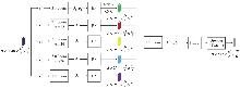
Fig. 2
ASPP processing module in the MSFE framework"
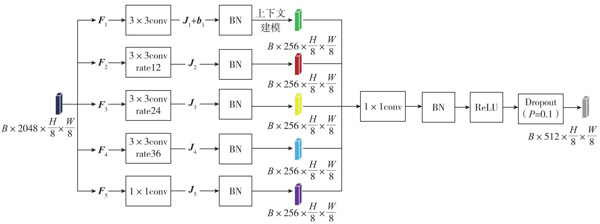
Fig. 3
OC self-attention mechanism"
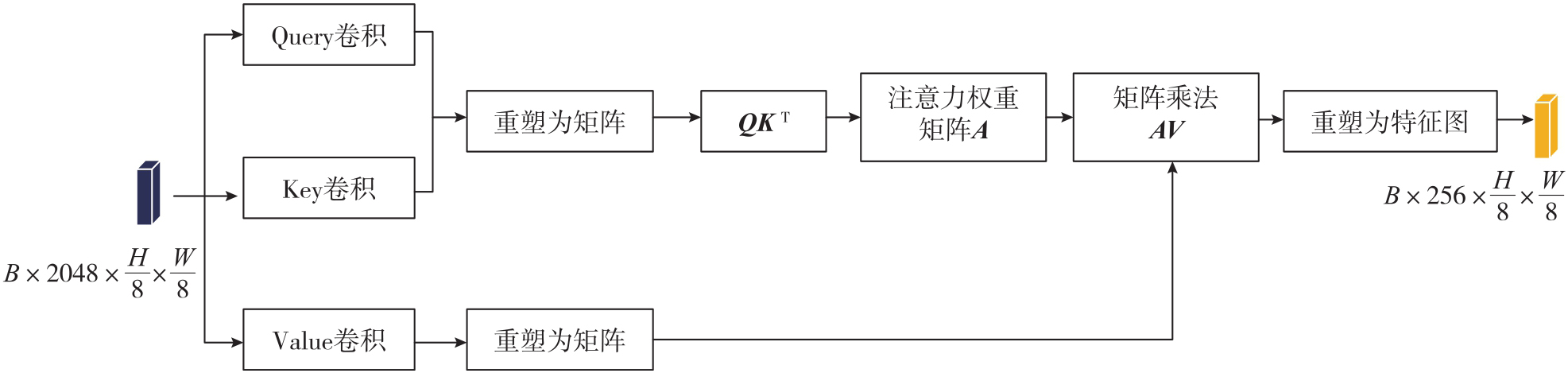
Fig. 4
Overview map of the study area"
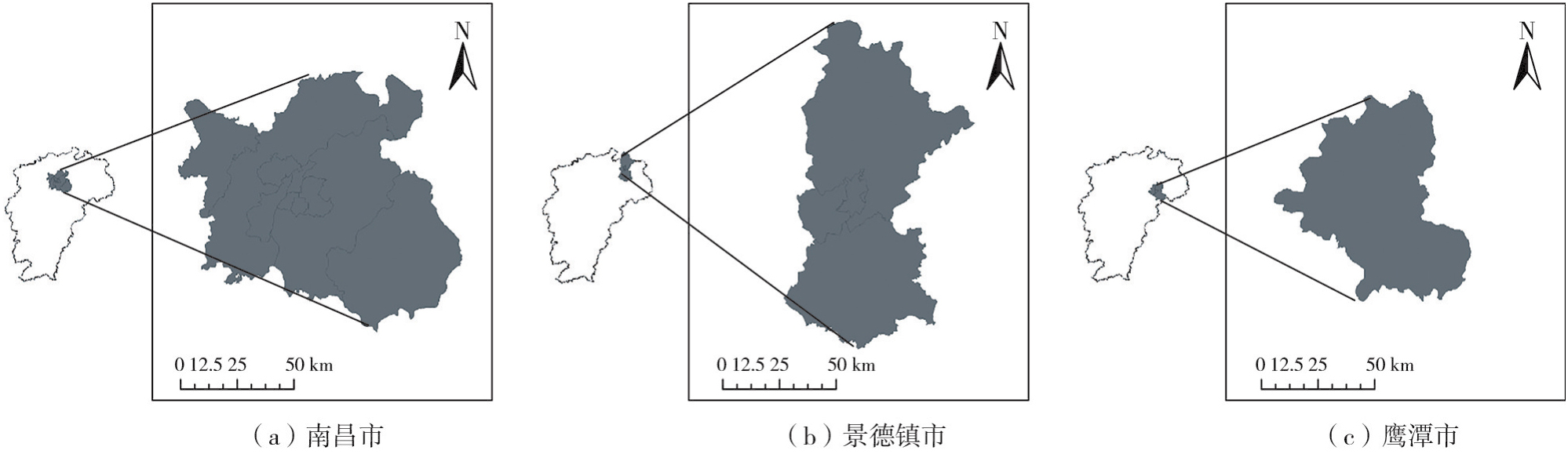
Fig. 5
Remote sensing image of study area"
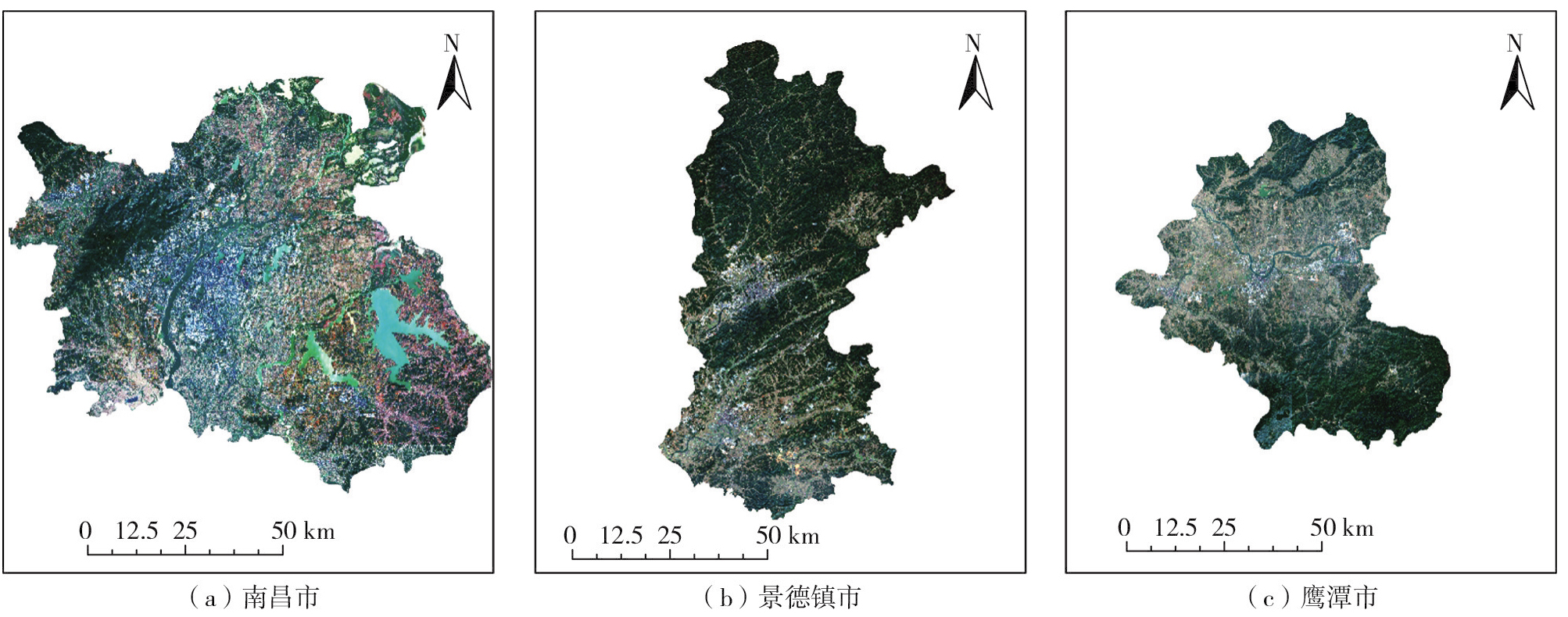
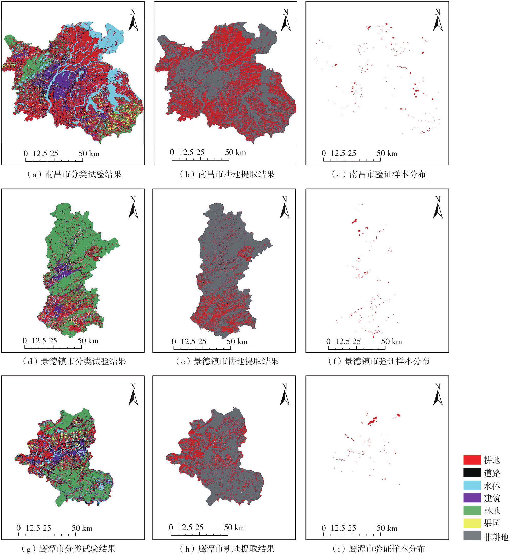
Fig. 6
Experimental results and distribution of verification samples"
Tab. 2
Accuracy evaluation of comparative experiments"
| 研究区 | 算法 | OA | Kappa | MCA | 耕地IoU | 耕地F1值 |
|---|---|---|---|---|---|---|
| 南昌市 | MSFE-OCNet | 92.87 | 90.50 | 91.33 | 90.03 | 94.76 |
| U-Net | 91.32 | 88.46 | 89.98 | 86.92 | 93.00 | |
| GTNet | 89.27 | 85.71 | 86.86 | 87.72 | 93.46 | |
| SAM | 89.10 | 85.48 | 87.22 | 84.44 | 91.56 | |
| DeepLabV3+ | 88.29 | 84.38 | 86.17 | 82.88 | 90.64 | |
| 景德镇市 | MSFE-OCNet | 93.69 | 91.56 | 92.15 | 92.73 | 96.23 |
| U-Net | 91.81 | 89.05 | 90.27 | 88.78 | 94.05 | |
| GTNet | 89.60 | 86.10 | 87.30 | 87.93 | 93.58 | |
| SAM | 89.56 | 86.01 | 87.44 | 86.18 | 92.58 | |
| DeepLabV3+ | 88.64 | 84.80 | 86.82 | 83.08 | 90.76 | |
| 鹰潭市 | MSFE-OCNet | 93.71 | 91.59 | 92.22 | 92.05 | 95.86 |
| U-Net | 91.64 | 88.84 | 90.55 | 87.14 | 93.13 | |
| GTNet | 90.08 | 86.75 | 87.78 | 88.89 | 94.12 | |
| SAM | 89.71 | 86.24 | 87.68 | 85.88 | 92.40 | |
| DeepLabV3+ | 88.95 | 85.21 | 86.92 | 84.02 | 91.32 |
Tab. 3
PA and UA metrics of different classes for each algorithm in comparative experiments in Nanchang"
| 类别 | MSFE-OCNet | U-Net | GTNet | SAM | DeepLabV3+ | |||||
|---|---|---|---|---|---|---|---|---|---|---|
| PA | UA | PA | UA | PA | UA | PA | UA | PA | UA | |
| 耕地 | 95.41 | 94.11 | 93.05 | 92.95 | 94.00 | 92.92 | 92.35 | 90.79 | 91.64 | 89.66 |
| 果园 | 86.96 | 88.26 | 85.64 | 86.83 | 81.76 | 81.67 | 82.50 | 84.28 | 81.23 | 82.53 |
| 林地 | 92.67 | 92.85 | 91.94 | 90.89 | 87.37 | 87.90 | 88.20 | 88.83 | 87.92 | 87.86 |
| 建筑 | 90.38 | 91.82 | 89.45 | 89.06 | 84.63 | 84.71 | 84.83 | 85.23 | 83.45 | 85.83 |
| 道路 | 88.39 | 88.93 | 86.82 | 86.79 | 82.39 | 82.76 | 83.20 | 84.10 | 81.51 | 83.35 |
| 水体 | 94.17 | 95.49 | 92.99 | 94.83 | 91.01 | 93.39 | 92.22 | 93.70 | 91.26 | 94.03 |
Tab. 4
PA and UA metrics of different classes for each algorithm in comparative experiments in Jingdezhen"
| 类别 | MSFE-OCNet | U-Net | GTNet | SAM | DeepLabV3+ | |||||
|---|---|---|---|---|---|---|---|---|---|---|
| PA | UA | PA | UA | PA | UA | PA | UA | PA | UA | |
| 耕地 | 96.74 | 95.72 | 94.38 | 93.73 | 94.07 | 93.09 | 93.79 | 91.40 | 91.68 | 89.86 |
| 果园 | 87.99 | 88.60 | 85.57 | 87.15 | 82.20 | 82.66 | 82.57 | 84.44 | 82.16 | 83.59 |
| 林地 | 92.78 | 93.16 | 91.84 | 91.14 | 88.28 | 88.30 | 88.06 | 89.73 | 88.29 | 89.12 |
| 建筑 | 91.44 | 91.55 | 89.38 | 89.49 | 84.69 | 85.22 | 84.85 | 85.98 | 84.80 | 86.34 |
| 道路 | 89.41 | 89.68 | 87.37 | 87.40 | 82.80 | 83.56 | 83.10 | 84.80 | 82.08 | 83.24 |
| 水体 | 94.54 | 96.76 | 93.10 | 95.67 | 91.76 | 94.10 | 92.28 | 93.22 | 91.92 | 93.21 |
Tab. 5
PA and UA metrics of different classes for each algorithm in comparative experiments in Yingtan"
| 类别 | MSFE-OCNet | U-Net | GTNet | SAM | DeepLabV3+ | |||||
|---|---|---|---|---|---|---|---|---|---|---|
| PA | UA | PA | UA | PA | UA | PA | UA | PA | UA | |
| 耕地 | 96.69 | 95.05 | 93.62 | 92.64 | 94.87 | 93.38 | 93.44 | 91.39 | 92.44 | 90.22 |
| 果园 | 88.49 | 89.61 | 86.95 | 87.05 | 83.00 | 83.17 | 83.07 | 84.63 | 82.08 | 84.18 |
| 林地 | 92.75 | 93.28 | 91.22 | 91.79 | 88.14 | 89.12 | 89.09 | 90.18 | 88.44 | 88.90 |
| 建筑 | 90.97 | 92.35 | 89.99 | 90.00 | 84.80 | 85.56 | 84.40 | 85.87 | 84.41 | 86.91 |
| 道路 | 89.59 | 90.06 | 88.04 | 88.14 | 83.35 | 84.15 | 83.96 | 84.95 | 82.15 | 83.31 |
| 水体 | 94.85 | 97.08 | 93.49 | 95.86 | 92.50 | 94.32 | 92.10 | 93.52 | 92.01 | 93.97 |
Fig. 7
Location of representative areas"
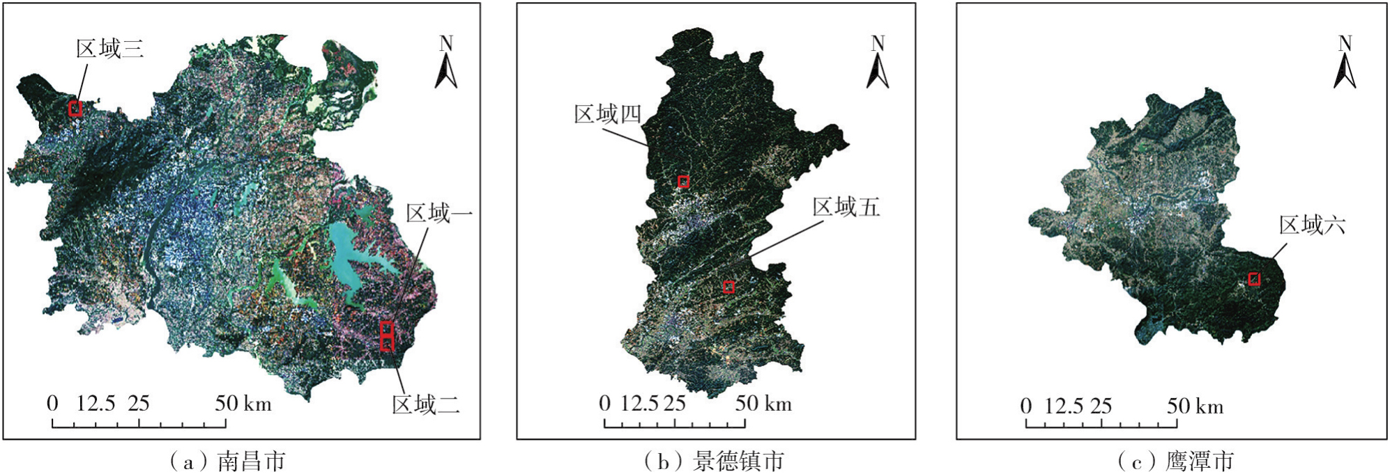
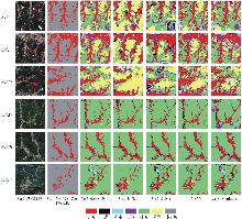
Fig. 8
Presentation of comparative experiment"

Tab. 6
Accuracy verification of ablation experiment in Nanchang"
| 算法 | 联合损失函数 | ASPP | 多分支OC | OA | Kappa | MCA | 耕地IoU | 耕地F1值 |
|---|---|---|---|---|---|---|---|---|
| MSFE-OCNet | √ | √ | √ | 92.87 | 90.50 | 91.33 | 90.03 | 94.76 |
| 算法A | √ | 90.29 | 84.12 | 78.80 | 78.87 | 88.19 | ||
| 算法B | √ | √ | 83.11 | 77.05 | 77.39 | 71.20 | 83.18 | |
| 算法C | √ | √ | 89.25 | 85.51 | 82.07 | 79.84 | 88.81 | |
| 算法D | √ | √ | 81.37 | 75.36 | 74.63 | 70.76 | 82.88 |
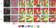
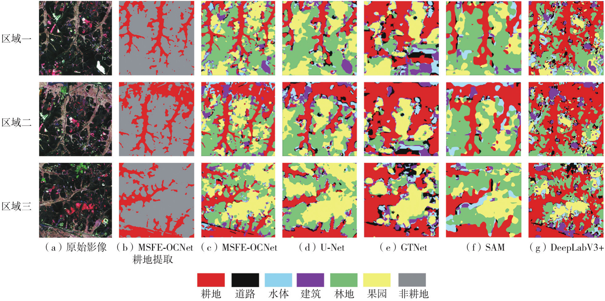
Fig. 9
Presentation of ablation experiment in Nanchang"
Tab. 7
Comparison of accuracy results with different weight ratios of joint loss function"
| 算法 | OA | 耕地IoU | 耕地F1值 |
|---|---|---|---|
| 0.1LCE+0.9LDice | 89.73 | 85.32 | 92.08 |
| 0.2LCE+0.8LDice | 90.67 | 87.61 | 93.40 |
| 0.5LCE+0.5LDice | 92.87 | 90.03 | 94.76 |
| 0.8LCE+0.2LDice | 91.39 | 88.47 | 93.88 |
| 0.9LCE+0.1LDice | 90.26 | 86.25 | 92.62 |
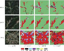
Fig. 10
Experimental results of dilation rate for multi-scale farmland parcels"

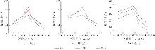
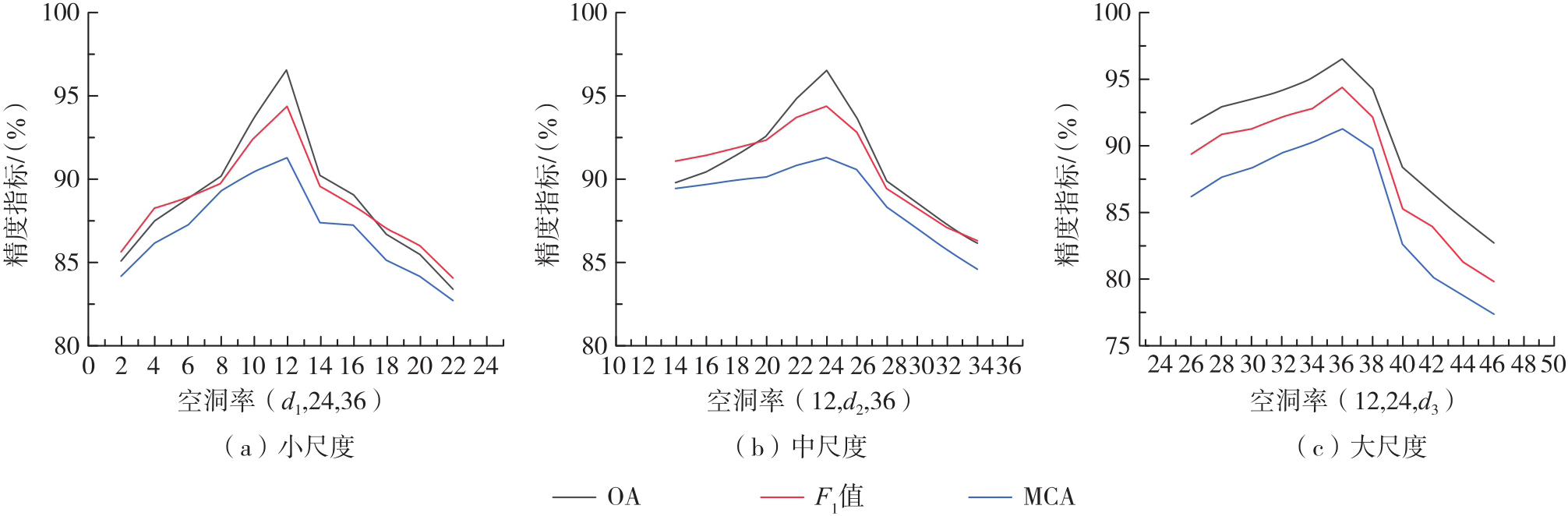
Fig. 11
Line chart of accuracy comparison among different scales"
Tab. 8
Ablation accuracy of OC branches, scales and attention mechanisms"
| 算法/注意力模块设置 | OA | Kappa系数 | MCA | 耕地IoU | 耕地F1值 |
|---|---|---|---|---|---|
| OC(1) | 82.24 | 81.75 | 78.36 | 77.18 | 87.12 |
| OC(1,2) | 83.43 | 83.21 | 79.54 | 78.25 | 87.80 |
| OC(1,2,3) | 89.05 | 88.14 | 83.72 | 82.43 | 90.37 |
| OC(1,2,4) | 92.87 | 90.50 | 91.33 | 90.03 | 94.76 |
| OC(1,2,5) | 91.06 | 89.73 | 85.21 | 83.86 | 91.22 |
| OC(1,2,4,8) | 84.21 | 83.54 | 79.86 | 78.52 | 87.97 |
| OC(2,4,8) | 86.47 | 85.62 | 81.47 | 80.15 | 88.98 |
| CBAM注意力 | 81.14 | 80.62 | 77.24 | 76.04 | 86.39 |
| SE注意力 | 82.12 | 81.63 | 78.15 | 77.03 | 87.02 |
| [1] | Wang Mengyu, Yan Zhiyuan, Feng Yingchao, et al. Multi-task learning of semantic segmentation and height estimation for multi-modal remote sensing images[J]. Journal of Geodesy and Geoinformation Science, 2023, 6(4): 27-39. |
| [2] |
吴田军, 李曼嘉, 骆剑承, 等. 耦合空间分布模式的复杂山区地块作物遥感分类方法[J]. 测绘学报, 2025, 54(7): 1215-1229. DOI: .
doi: 10.11947/j.AGCS.2025.20240440 |
|
Wu Tianjun, Li Manjia, Luo Jiancheng, et al. Remote sensing classification method of crops in complex mountainous parcels coupled with spatial distribution patterns[J]. Acta Geodaetica et Cartographica Sinica, 2025, 54(7): 1215-1229. DOI: .
doi: 10.11947/j.AGCS.2025.20240440 |
|
| [3] | Ma Xianguang, Tang Bohui, He Feng, et al. Extraction and prediction of spatiotemporal pattern characteristics of farmland non-grain conversion in Yunnan province based on multi-source data[J]. Remote Sensing, 2025, 17(19): 3295. |
| [4] | Xu Weicheng, Lan Yubin, Li Yuanhong, et al. Classification method of cultivated land based on UAV visible light remote sensing[J]. International Journal of Agricultural and Biological Engineering, 2019, 12(3): 103-109. |
| [5] | Wu Jiayong, Ding Xue, Wang Jinliang, et al. MAMNet: lightweight multi-attention collaborative network for fine-grained cropland extraction from Gaofen-2 remote sensing imagery[J]. Agriculture, 2025, 15(11): 1152. |
| [6] | 李倩楠, 张杜娟, 潘耀忠, 等. MPSPNet和UNet网络下山东省高分辨耕地遥感提取[J]. 遥感学报, 2023, 27(2): 471-491. |
| Li Qiannan, Zhang Dujuan, Pan Yaozhong, et al. High-resolution cropland extraction in Shandong province using MPSPNet and UNet network[J]. National Remote Sensing Bulletin, 2023, 27(2): 471-491. | |
| [7] | Liu Han, Wang Yu, Sang Lingling, et al. Evaluation of spatiotemporal changes in cropland quantity and quality with multi-source remote sensing[J]. Land, 2023, 12(9): 1764. |
| [8] | Tao Kunjian, Li He, Huang Chong, et al. Extraction of cropland based on multi-source remote sensing and an improved version of the deep learning-based segment anything model (SAM)[J]. Agronomy, 2025, 15(5): 1139. |
| [9] |
刘巍, 吴志峰, 骆剑承, 等. 深度学习支持下的丘陵山区耕地高分辨率遥感信息分区分层提取方法[J]. 测绘学报, 2021, 50(1): 105-116. DOI: .
doi: 10.11947/j.AGCS.2021.20190448 |
|
Liu Wei, Wu Zhifeng, Luo Jiancheng, et al. A divided and stratified extraction method of high-resolution remote sensing information for cropland in hilly and mountainous areas based on deep learning[J]. Acta Geodaetica et Cartographica Sinica, 2021, 50(1): 105-116. DOI: .
doi: 10.11947/j.AGCS.2021.20190448 |
|
| [10] | Zhang Dujuan, Zhu Xiufang, Pan Yaozhong, et al. Comparative analysis of deep learning and traditional methods for high-resolution cropland extraction with different training data characteristics[J]. Land, 2025, 14(10): 2038. |
| [11] | Xie Meilin, Liu Gang, He Jing, et al. Fine extraction of cultivated land parcels in Chengdu Plain area based on CDUSU-net network model of Gaofen-2 imagery[J]. Journal of the Indian Society of Remote Sensing, 2025, 53(6): 1785-1798. |
| [12] |
陈启浩, 李广潮, 曹文静, 等. 综合时序光学和SAR数据的南方多云雨地区耕地种植强度提取[J]. 测绘学报, 2024, 53(12): 2361-2374. DOI: .
doi: 10.11947/j.AGCS.2024.20230497 |
|
Chen Qihao, Li Guangchao, Cao Wenjing, et al. Cropland intensity extraction combined using optical and SAR time-series in cloudy and rainy areas of Southern China[J]. Acta Geodaetica et Cartographica Sinica, 2024, 53(12): 2361-2374. DOI: .
doi: 10.11947/j.AGCS.2024.20230497 |
|
| [13] | Liu Shukuan, Cao Shi, Lu Xia, et al. Lightweight deep learning model, ConvNeXt-U: an improved U-Net network for extracting cropland in complex landscapes from Gaofen-2 images[J]. Sensors, 2025, 25(1): 261. |
| [14] | Huang Zhongxin, Jing Haitao, Liu Yueming, et al. Segment anything model combined with multi-scale segmentation for extracting complex cultivated land parcels in high-resolution remote sensing images[J]. Remote Sensing, 2024, 16(18): 3489. |
| [15] | Zhang Dujuan, Li Yiping, Shen Yucai, et al. A dual-branch framework integrating the segment anything model and semantic-aware network for high-resolution cropland extraction[J]. Remote Sensing, 2025, 17(20): 3424. |
| [16] | Fang Zheng, Gong Yuhang, Zhu Heli, et al. A refined SMR-DeepLabV3+ model for cultivated land extraction from cross-view imagery using an attention mechanism[J]. Discover Sustainability, 2025, 6(1): 583. |
| [17] | Lu Yihang, Li Lin, Dong Wen, et al. A method for cropland layer extraction in complex scenes integrating edge features and semantic segmentation[J]. Agriculture, 2024, 14(9): 1553. |
| [18] | 段理, 王石英. 川中丘陵地区撂荒地的遥感提取方法研究[J]. 智能城市, 2023, 9(12): 35-38. |
| Duan Li, Wang Shiying. Research on remote sensing extraction methods for abandoned land in hilly areas of central Sichuan[J]. Intelligent City, 2023, 9(12): 35-38. | |
| [19] | 胡金梅, 董张玉, 杨学志. 一种面向对象的高分辨率遥感影像信息提取方法[J]. 地理空间信息, 2021, 19(9): 10-13, 18. |
| Hu Jinmei, Dong Zhangyu, Yang Xuezhi. Object-oriented high-resolution remote sensing image information extraction method[J]. Geospatial Information, 2021, 19(9): 10-13, 18. | |
| [20] | Chen Yanxi, Xiao Xingzhu, Zhang Yongle, et al. A novel deep learning model for extracting arable land from high-resolution remote sensing images in hilly areas: a case study in the Sichuan Basin of Southwest China[J]. Geocarto International, 2024, 39: 2400493. |
| [21] | Zhang Xinchang, Shi Qian, Sun Ying, et al. The review of land use/land cover mapping AI methodology and application in the era of remote sensing big data[J]. Journal of Geodesy and Geoinformation Science, 2024, 7(3): 1-23. |
| [22] | Liu Yunyu, Yuan Jinpeng. ERSNet: Lightweight attention-guided network for remote sensing scene image classification[J]. Journal of Geodesy and Geoinformation Science, 2025, 8(1): 30-46. |
| [23] | 王仁儒. 基于多源遥感与深度学习的山地耕地地块提取与分类研究[D]. 贵阳: 贵州师范大学, 2025. |
| Wang Renru. Research on extraction and classification of mountain cultivated land plots based on multi-source remote sensing and deep learning[D]. Guiyang: Guizhou Normal University, 2025. | |
| [24] | 郭宇航, 黄玉春. 基于Gabor卷积和拓扑连接的耕地地块提取网络[J]. 测绘地理信息, 2025, 50(6): 133-138. |
| Guo Yuhang, Huang Yuchun. Farmland plot extraction network based on Gabor convolution and topological connection[J]. Journal of Geomatics, 2025, 50(6): 133-138. | |
| [25] | 于洋, 李哲凡, 谢淑娟, 等. 基于面向对象法与U-Net模型的广东省云浮市云城区耕地后备资源遥感提取[J]. 华南农业大学学报, 2026, 47(1): 42-51. |
| Yu Yang, Li Zhefan, Xie Shujuan, et al. Remote sensing extraction of cultivated land reserve resources in Yuncheng district, Yunfu city, Guangdong province based on object-oriented method and U-Net model[J]. Journal of South China Agricultural University, 2026, 47(1): 42-51. | |
| [26] | 侯新刚, 王勤令, 伟锋. 基于多尺度注意力视觉Mamba U-Net的耕地遥感分割方法[J]. 农业机械学报, 2026, 57(4): 279-286. |
| Hou Xingang, Wang Qinling, Wei Feng. Remote sensing segmentation of cultivated land based on multi-scale attention vision Mamba U-Net[J]. Transactions of the Chinese Society for Agricultural Machinery, 2026, 57(4): 279-286. | |
| [27] | Dong Yong, Wang Hongyan, Zhang Yuan, et al. Accurate parcel extraction combined with multi-resolution remote sensing images based on SAM[J]. Agriculture, 2025, 15(9): 976. |
| [28] | Weng Yijie, Li Zongmei, Tang Guofeng, et al. OCNet-based water body extraction from remote sensing images[J]. Water, 2023, 15(20): 3557. |
| [29] |
彭代锋, 刘雪莲, 鲁梦飞, 等. 基于多尺度跨模态特征融合的异源遥感影像洪水变化检测[J]. 测绘学报, 2026, 55(2): 328-343. DOI: .
doi: 10.11947/j.AGCS.2026.20250331 |
|
Peng Daifeng, Liu Xuelian, Lu Mengfei, et al. Heterogeneous remote sensing image flood change detection based on multi-scale crossmodal feature fusion[J]. Acta Geodaetica et Cartographica Sinica, 2026, 55(2): 328-343. DOI: .
doi: 10.11947/j.AGCS.2026.20250331 |
| [1] | Xiaohu Lin, Tao Yan, Bisheng Yang, Chi Chen, Yinan Gao, Xiang Wang. An open-vocabulary semantic-enhanced 3DGS-SLAM method for complex underground spaces [J]. Acta Geodaetica et Cartographica Sinica, 2026, 55(9): 1582-1598. |
| [2] | Xin Xiong, Guowang Jin, Jiahao Li, Hao Ye, Le Yang. Research on rational function model for Tianhui-2 bistatic imaging geometry [J]. Acta Geodaetica et Cartographica Sinica, 2026, 55(9): 1599-1611. |
| [3] | Sihan Liu, Shiwei Shao, Yuefeng Lu, Ziqi Ding, Chunlin Mu, Xiaolei Dou, Chengzhe Lü, Zhirui Jia, Zhenjie Jiao. Heterogeneous building point cloud registration via deformable self-attention and density-invariant keypoint detection [J]. Acta Geodaetica et Cartographica Sinica, 2026, 55(9): 1630-1640. |
| [4] | Baokun Feng. Multi-scale forest above ground biomass estimation based on spaceborne, drone and terrestrial LiDAR data [J]. Acta Geodaetica et Cartographica Sinica, 2026, 55(9): 1706-1706. |
| [5] | Tengfeng Tang, Renyuan Liu, Chang Liu, Yangang Zhao, Dan Pan, Yuanxin Ye. Multi-modal image matching based on modality reconstruction and feature perturbation learning [J]. Acta Geodaetica et Cartographica Sinica, 2026, 55(8): 1343-1356. |
| [6] | Jianmei Wang, Yu Duan, Shaoming Zhang, Xinyan Li. Land use classification from evidence photos via the integration of vision foundation models and graph neural networks [J]. Acta Geodaetica et Cartographica Sinica, 2026, 55(8): 1400-1413. |
| [7] | Xijiang Chen, Minkun Zeng, Wei Xuan, Jingui Zou, Xianghong Hua. Multi-scale supervoxel feature aggregation network for three-dimensional point cloud semantic segmentation [J]. Acta Geodaetica et Cartographica Sinica, 2026, 55(8): 1414-1424. |
| [8] | Yongqi Sun, Chenguang Dai, Zhenchao Zhang, Jinchun Qin, Yu Su. A cross-domain semantic segmentation framework fusing relative depth for high-resolution optical satellite remote sensing imagery [J]. Acta Geodaetica et Cartographica Sinica, 2026, 55(8): 1425-1438. |
| [9] | Han Zhu, Chenguang Dai, Zhenchao Zhang, Xuanguang Liu, Jinhao Lu. Point cloud change detection with geometric structure refinement and entropy-attention mechanism [J]. Acta Geodaetica et Cartographica Sinica, 2026, 55(8): 1439-1451. |
| [10] | Xiangyu Zhao, Chunju Zhang, Yifan Pei, Chenxi Li, Jun Zhang, Wei Xu, Chun Lan, Linfeng Lü, Hongbo Liang. SCA-SAM: semantic segmentation for remote sensing images based on scale context attention and efficient SAM transfer [J]. Acta Geodaetica et Cartographica Sinica, 2026, 55(8): 1452-1464. |
| [11] | Shichao Jia. Active microwave remote sensing monitoring of permafrost surface deformation and active layer thickness along the Qinghai-Xizang engineering corridor [J]. Acta Geodaetica et Cartographica Sinica, 2026, 55(8): 1513-1513. |
| [12] | Yibo He. Research on algorithm for extracting surface damage information in mining areas using 3D point cloud data [J]. Acta Geodaetica et Cartographica Sinica, 2026, 55(8): 1516-1516. |
| [13] | Xin Bao. Monitoring and analyzing of dynamic evolution of crop phenology and soil moisture in the Eastern Henan Plain by SAR remote sensing [J]. Acta Geodaetica et Cartographica Sinica, 2026, 55(8): 1520-1520. |
| [14] | Jun Gong, Jianjun Luo, Shengnan Ke, Shibin Li, Weicong Chen, Le Qin, Shengjun Tang. An adaptive-pruning 3D Gaussian SLAM method for real-time high-fidelity indoor scene modeling [J]. Acta Geodaetica et Cartographica Sinica, 2026, 55(7): 1266-1277. |
| [15] | Qinghua Tan, Heng Qi, Hongyu Shi, Luliang Tang, Zihan Kan, Hong Yang, Lele Sun, Yafei Liu, Zhengxiong Gu. Multi-source low-altitude risk quantification and route generation in urban environments [J]. Acta Geodaetica et Cartographica Sinica, 2026, 55(7): 1306-1320. |
| Viewed | ||||||
|
Full text |
|
|||||
|
Abstract |
|
|||||
