

Acta Geodaetica et Cartographica Sinica ›› 2025, Vol. 54 ›› Issue (3): 563-576.doi: 10.11947/j.AGCS.2025.20240138
• Cartography and Geoinformation • Previous Articles Next Articles
Youneng SU1( ), Qing XU1(), Qun SUN1, Xinming ZHU1, Fubing ZHANG1, Bo LIU2
Received:2024-04-25
Online:2025-04-11
Published:2025-04-11
Contact:
Qing XU
E-mail:youneng_2000@163.com;xq1982_no.1@163.com
About author:SU Youneng (2000—), male, postgraduate, majors in geographic knowledge graph and automatic generalization of maps. E-mail: youneng_2000@163.com
Supported by:CLC Number:
Youneng SU, Qing XU, Qun SUN, Xinming ZHU, Fubing ZHANG, Bo LIU. A method for automatic buildings aggregation constrained by proximity edges[J]. Acta Geodaetica et Cartographica Sinica, 2025, 54(3): 563-576.
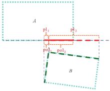
Fig. 1
MBR projection"
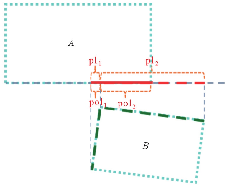
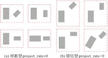
Fig. 2
Spatial structural relations of proximity buildings"
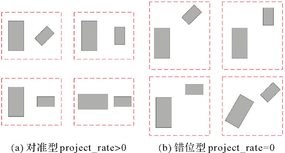
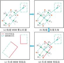
Fig. 3
The generation of MBR proximity edges"

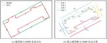
Fig. 4
Buildings boundaries classification"
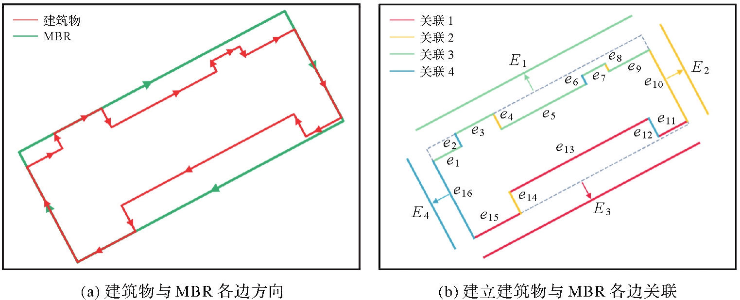
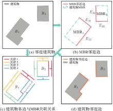
Fig. 5
The generation of building proximity edges"
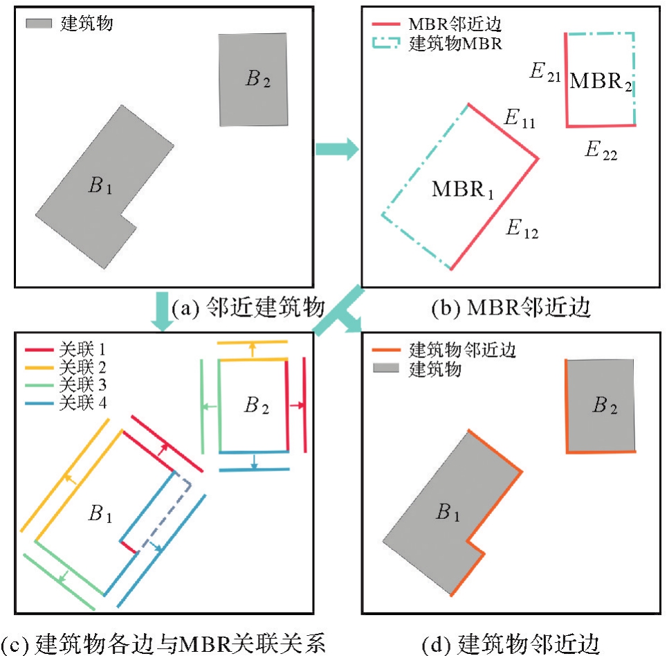
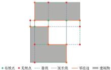
Fig. 6
Projection points selection for proximity edges"
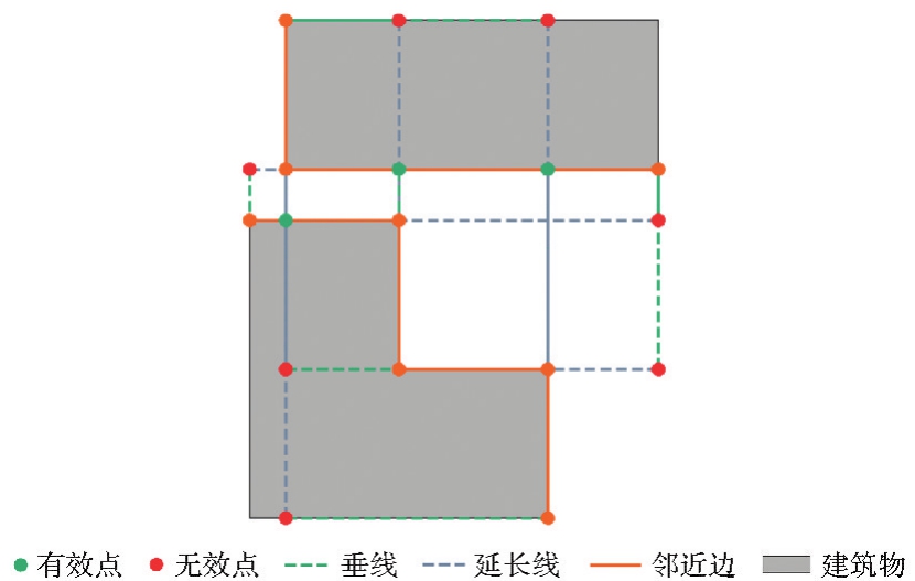
Fig. 7
Bridging polygon generation under cross projection"
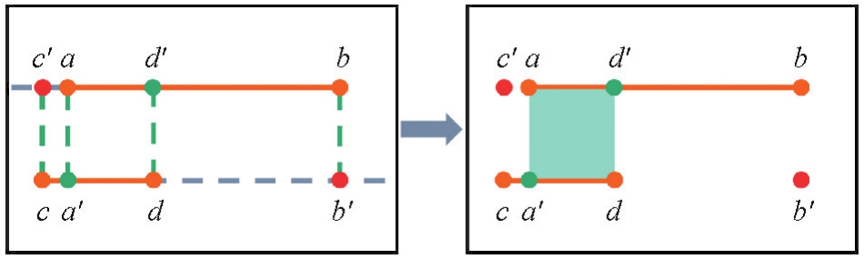
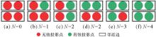
Fig. 8
Analysis of proximity edges projection points of alignment type buildings"
Tab. 1
Formation of alignment type buildings bridging polygons"
| 类别 | 邻近边上投影点数量 | 投影点图示 | 桥接面图示 | 是否构建桥接面 |
|---|---|---|---|---|
| Ⅰ | 2 |  |  | 是 |
| Ⅱ | 2 |  |  | 是 |
| Ⅲ | 3 |  |  | 是 |
| Ⅳ | 4 |  |  | 是 |
Tab. 2
Formation of dislocation type buildings bridging polygons"
| 类别 | 邻近边上交点数量 | 交点图示 | 桥接面图示 | 是否构建桥接面 |
|---|---|---|---|---|
| Ⅰ | 0 |  |  | 否 |
| Ⅱ | 1 |  |  | 是 |
| Ⅲ | 2 |  |  | 是 |
| Ⅳ | 1 |  |  | 是 |
| Ⅴ | 0 |  | 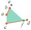 | 是 |
Fig. 9
Aggregation of alignment type buildings"

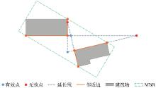
Fig. 10
Intersections selection for proximity edges"
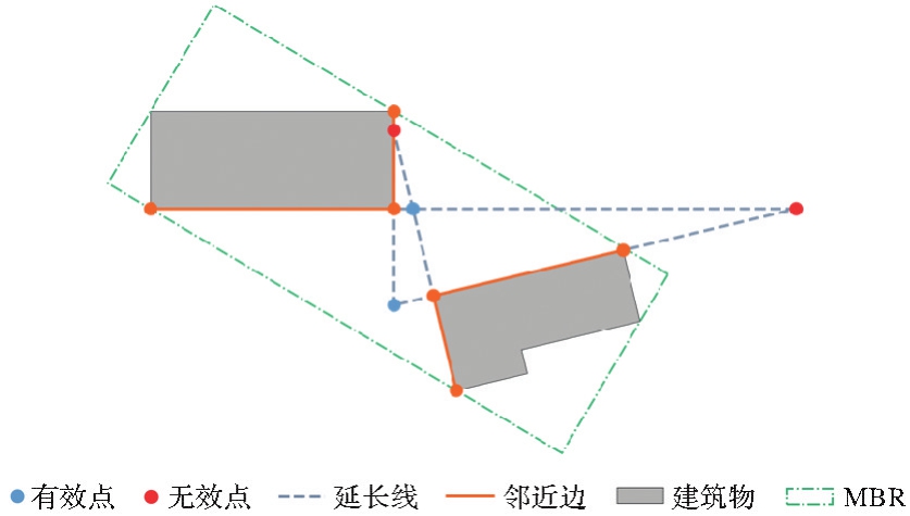
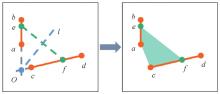
Fig. 11
Bridging polygon generation under the constraint of angular bisectors"
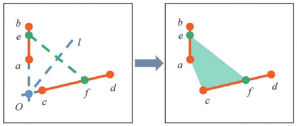
Fig. 12
Aggregation of dislocation type buildings"
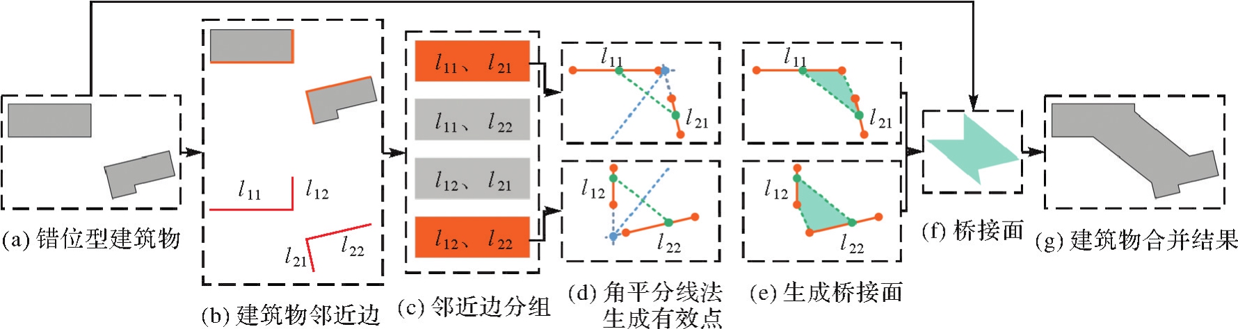
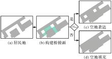
Fig. 13
Expression and filling of blank areas"
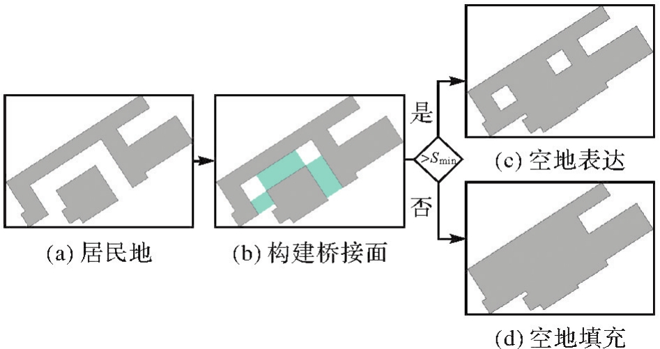

Fig. 14
The flowchart of building aggregation"
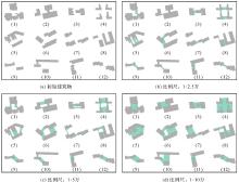
Fig. 15
Aggregation of typical buildings (non proportional display)"
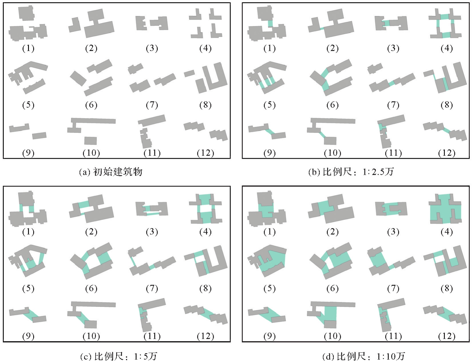
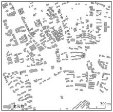
Fig. 16
Experiment data 2"
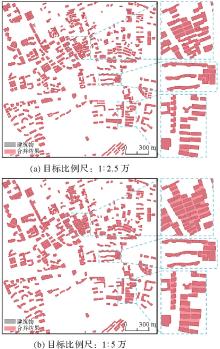
Fig. 17
Aggregation of group buildings"
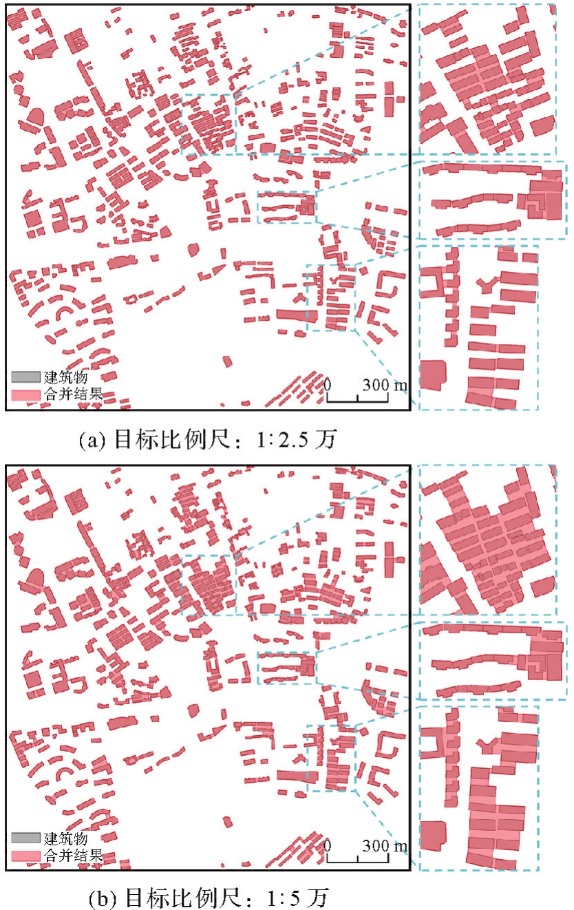
Tab. 3
Experimental indices of group buildings aggregation"
| 试验 | 建筑物数量 | 目标比例尺 | 总面积/m2 | 直角占比/(%) | 建筑物数量变化率/(%) | 建筑物面积变化率/(%) |
|---|---|---|---|---|---|---|
| 试验1 | 327 | 1∶2.5万 | 565 825.72 | 75.44 | -50.00 | 7.41 |
| 试验2 | 177 | 1∶5万 | 663 545.11 | 68.59 | -72.94 | 25.96 |
Tab. 4
Comparison results of the evaluation parameters"
| 试验方法 | 建筑物数量 | 建筑物面积/m2 | 建筑物直角占比/(%) | 建筑物数量变化率/(%) | 建筑物面积变化率/(%) |
|---|---|---|---|---|---|
| 本文方法 | 45 | 255 539.68 | 84.12 | -81.14 | 39.03 |
| Arc Map方法 | 82 | 247 399.73 | 82.31 | -64.04 | 34.60 |
| 文献[ | 53 | 250 345.93 | 77.39 | -76.75 | 36.20 |
| 文献[ | 54 | 247 482.89 | 81.49 | -76.32 | 34.65 |
| 文献[ | 65 | 252 183.39 | 81.17 | -71.49 | 37.20 |
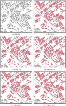
Fig. 18
Comparison test of the aggregation results"

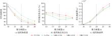
Fig. 19
Each index changes"

| [1] | 刘先林. 为社会进步服务的测绘高新技术[J]. 测绘科学, 2019, 44(6): 1-15. |
| LIU Xianlin. High technologies of surveying and mapping for social progress[J]. Science of Surveying and Mapping, 2019, 44(6): 1-15. | |
| [2] |
胡慧明, 钱海忠, 何海威, 等. 采用层次分析法的面状居民地自动选取[J]. 测绘学报, 2016, 45(6): 740-746,755. DOI:.
doi: 10.11947/j.AGCS.2016.20150078 |
|
HU Huiming, QIAN Haizhong, HE Haiwei, et al. Auto-selection of areal habitation based on analytic hierarchy process[J]. Acta Geodaetica et Cartographica Sinica, 2016, 45(6): 740-746,755. DOI:.
doi: 10.11947/j.AGCS.2016.20150078 |
|
| [3] | 王家耀. 地图集:重构复杂非线性地理世界的“百科全书”[J]. 测绘地理信息, 2021, 46(1): 1-8. |
| WANG Jiayao. Atlas: the “Encyclopedia” of reconstructing complex nonlinear geographical world[J]. Journal of Geomatics, 2021, 46(1): 1-8. | |
| [4] |
尹烁, 闫小明, 晏雄锋. 基于特征边重构的建筑物化简方法[J]. 测绘学报, 2020, 49(6): 703-710. DOI:.
doi: 10.11947/j.AGCS.2020.20190299 |
|
YIN Shuo, YAN Xiaoming, YAN Xiongfeng. Simplification method of building polygon based on feature edges reconstruction[J]. Acta Geodaetica et Cartographica Sinica, 2020, 49(6): 703-710. DOI:.
doi: 10.11947/j.AGCS.2020.20190299 |
|
| [5] | 唐曾杨, 艾廷华, 徐海江. 地理知识图谱下的建筑群空间分布模式推理[J]. 地球信息科学学报, 2023, 25(6): 1202-1214. |
| TANG Zengyang, AI Tinghua, XU Haijiang. Reasoning of spatial distribution pattern of building cluster based on geographic knowledge graph[J]. Journal of Geo-Information Science, 2023, 25(6): 1202-1214. | |
| [6] |
魏智威, 肖屹, 童莹, 等. 基于知识图谱的直线型建筑物模式识别方法[J]. 测绘学报, 2023, 52(8): 1355-1363. DOI:.
doi: 10.11947/j.AGCS.2023.20220121 |
|
WEI Zhiwei, XIAO Yi, TONG Ying, et al. Linear building pattern recognition via spatial knowledge graph[J]. Acta Geodaetica et Cartographica Sinica, 2023, 52(8): 1355-1363. DOI:.
doi: 10.11947/j.AGCS.2023.20220121 |
|
| [7] | 朵天林. 居民地综合决策模型和方法研究[D]. 郑州: 信息工程大学, 2020. |
| DUO Tianlin. Research on decision model and method of cartographic generalization of residential areas[D]. Zhengzhou: Information Engineering University, 2020. | |
| [8] | DU S, LUO L, CAO K, et al. Extracting building patterns with multilevel graph partition and building grouping[J]. ISPRS Journal of Photogrammetry and Remote Sensing, 2016, 122: 81-96. |
| [9] | YAN X, AI T, YANG M, et al. A graph convolutional neural network for classification of building patterns using spatial vector data[J]. ISPRS Journal of Photogrammetry and Remote Sensing, 2019, 150: 259-273. |
| [10] | WANG X, BURGHARDT D. A typification method for linear building groups based on stroke simplification[J]. Geocarto International, 2021, 36(15): 1732-1751. |
| [11] |
行瑞星, 武芳, 巩现勇, 等. 建筑群组合直线模式识别的模板匹配方法[J]. 测绘学报, 2021, 50(6): 800-811. DOI:.
doi: 10.11947/j.AGCS.2021.20200298 |
|
XING Ruixing, WU Fang, GONG Xianyong, et al. The template matching approach to combined collinear pattern recognition in building groups[J]. Acta Geodaetica et Cartographica Sinica, 2021, 50(6): 800-811. DOI:.
doi: 10.11947/j.AGCS.2021.20200298 |
|
| [12] | HE X, ZHANG X, XIN Q. Recognition of building group patterns in topographic maps based on graph partitioning and random forest[J]. ISPRS Journal of Photogrammetry and Remote Sensing, 2018, 136: 26-40. |
| [13] | WANG H, XU Y, HU A, et al. Building pattern recognition by using an edge-attention multi-head graph convolutional network[J]. International Journal of Geographical Information Science, 2018(32): 1-26. |
| [14] | WEI Z, XU W, XIAO Y, et al. Enhancing building pattern recognition through multi-scale data and knowledge graph: a case study of C-shaped patterns[J]. International Journal of Digital Earth, 2023, 16(1): 3860-3881. |
| [15] | 王光霞, 杨培. 数学形态学在居民地街区合并中的应用[J]. 测绘学院学报, 2000(3): 201-203,206. |
| WANG Guangxia, YANG Pei. Application of mathematic morphology in uniting blocks of residential area[J]. Journal of Institute of Surveying and Mapping, 2000(3): 201-203,206. | |
| [16] | 郭仁忠, 艾廷华. 制图综合中建筑物多边形的合并与化简[J]. 武汉测绘科技大学学报, 2000(1): 25-30. |
| GUO Renzhong, AI Tinghua. Simplification and aggregation of building polygon in automatic map generalization[J]. Journal of Wuhan Technical University of Surveying and Mapping, 2000(1): 25-30. | |
| [17] | SHEN Y, AI T, LI W, et al. A polygon aggregation method with global feature preservation using superpixel segmentation[J]. Computers, Environment and Urban Systems, 2019, 75: 117-131. |
| [18] | SESTER M, FENG Y, THIEMANN F. Building generalization using deep learning[J]. ISPRS-International Archives of the Photogrammetry, Remote Sensing and Spatial Information Sciences, 2018, XLII-4: 565-572. |
| [19] | 李安平, 翟仁健, 殷吉崇, 等. 顾及空间结构关系的居民地自动合并方法[J]. 武汉大学学报(信息科学版), 2024, 49(9): 1723-1733. |
| LI Anping, ZHAI Renjian, YIN Jichong, et al. Automatic aggregation of building considering the spatial structure[J]. Geomatics and Information Science of Wuhan University, 2024, 49(9): 1723-1733. | |
| [20] | PENG D, TOUYA G. Continuously generalizing buildings to built-up areas by aggregating and growing[C]//Proceedings of the 3rd ACM SIGSPATIAL Workshop on Smart Cities and Urban Analytics. Redondo Beach: ACM Press, 2017: 1-8. |
| [21] |
王勇, 罗安, 王慧慧, 等. 复杂建筑物最短邻近线多边形聚合法[J]. 测绘学报, 2021, 50(12): 1671-1682. DOI:.
doi: 10.11947/j.AGCS.2021.20200493 |
|
WANG Yong, LUO An, WANG Huihui, et al. A method of polygon aggregation for complex buildings based on shortest adjacent lines[J]. Acta Geodaetica et Cartographica Sinica, 2021, 50(12): 1671-1682. DOI:.
doi: 10.11947/j.AGCS.2021.20200493 |
|
| [22] |
陈占龙, 鲁谢春, 徐永洋. 基于图顶点深度聚类的建筑物合并方法[J]. 测绘学报, 2024, 53(4): 736-749. DOI:.
doi: 10.11947/j.AGCS.2024.20230316 |
|
CHEN Zhanlong, LU Xiechun, XU Yongyang. A building aggregation method based on deep clustering of graph vertices[J]. Acta Geodaetica et Cartographica Sinica, 2024, 53(4): 736-749. DOI:.
doi: 10.11947/j.AGCS.2024.20230316 |
|
| [23] | AI T, YIN H, SHEN Y, et al. A formal model of neighborhood representation and applications in urban building aggregation supported by Delaunay triangulation[J]. PLOS ONE, 2019, 14(7): e0218877. |
| [24] |
郭沛沛, 李成名, 殷勇. 建筑物合并的Delaunay三角网分类过滤法[J]. 测绘学报, 2016, 45(8): 1001-1007. DOI:.
doi: 10.11947/j.AGCS.2016.20150587 |
|
GUO Peipei, LI Chengming, YIN Yong. Classification and filtering of constrained delaunay triangulation for automated building aggregation[J]. Acta Geodaetica et Cartographica Sinica, 2016, 45(8): 1001-1007. DOI:.
doi: 10.11947/j.AGCS.2016.20150587 |
|
| [25] | 张巧凤. 应用Delaunay三角网进行城市居民地和路网自动综合理论和方法研究[D]. 太原: 太原理工大学, 2005. |
| ZHANG Qiaofeng. Study on the theory and method of automatic synthesis of urban residential land and road network by Delaunay triangulation[D]. Taiyuan: Taiyuan University of Technology, 2005. | |
| [26] | USUI H, TERAKI A, OKUNUKI KI, et al. A comparison of neighbourhood relations based on ordinary Delaunay diagrams and area Delaunay diagrams: an application to define the neighbourhood relations of buildings[J]. International Journal of Geographical Information Science, 2020, 34(11): 2177-2203. |
| [27] | ZHANG F, SUN Q, MA J, et al. A polygonal buildings aggregation method considering obstacle elements and visual clarity[J]. Geocarto International, 2023, 38(1): 2266672. |
| [28] | REGNAULD N. Algorithms for the amalgamation of topographic data[C]//Proceedings of the 21st International Cartographic Conference. Durban: [s.n.], 2003. |
| [29] | HE X, ZHANG X, YANG J. Progressive amalgamation of building clusters for map generalization based on scaling subgroups[J]. ISPRS International Journal of Geo-Information, 2018, 7(3): 116. |
| [30] | WANG L, ZHANG J, YAO G. The analysis and experiments of least-squares method for settlements generalization[C]//Proceedings of 2012 IEEE International Conference on Information Science and Technology. Wuhan: IEEE, 2012: 210-214. |
| [31] | 苏友能, 徐青, 朱新铭, 等. POI点要素空间邻近图质量评价——以Delaunay三角网和缓冲区构建方法为例[J]. 地理与地理信息科学, 2024, 40(3): 14-20. |
| SU Youneng, XU Qing, ZHU Xinming, et al. Quality evaluation on spatial proximity graph of POI based on Delaunay triangulation network and buffer construction method[J]. Geography and Geo-Information Science, 2024, 40(3): 14-20. | |
| [32] |
巩现勇, 武芳. 城市建筑群网格模式的图论识别方法[J]. 测绘学报, 2014, 43(9): 960-968. DOI:.
doi: 10.13485/j.cnki.11-2089.2014.0125 |
|
GONG Xianyong, WU Fang. The graph theory approach to grid pattern recognition in urban building groups[J]. Acta Geodaetica et Cartographica Sinica, 2014, 43(9): 960-968. DOI:.
doi: 10.13485/j.cnki.11-2089.2014.0125 |
|
| [33] |
肖天元, 艾廷华, 余华飞, 等. 地图综合图卷积神经网络点群简化方法[J]. 测绘学报, 2024, 53(1): 158-172. DOI:.
doi: 10.11947/j.AGCS.2024.20220584 |
|
XIAO Tianyuan, AI Tinghua, YU Huafei, et al. A point cluster simplification approach of graph convolutional neural network for map generalization[J]. Acta Geodaetica et Cartographica Sinica, 2024, 53(1): 158-172. DOI:.
doi: 10.11947/j.AGCS.2024.20220584 |
|
| [34] | 全国地理信息标准化技术委员会. 国家基本比例尺地图图式 第3部分:1∶25 000 1∶50 000 1∶100 000地形图图式:GB/T 20257.3—2017[S]. 北京: 中国标准出版社, 2017. |
| National Technical Committee for Geographic Information Standardization. Cartographic symbols for national fundamental scale maps: part 3: specifications for cartographic symbols 1∶25 000 1∶50 000 & 1∶100 000 topographic maps: GB/T 20257.3—2017[S]. Beijing: Standards Press of China, 2017. | |
| [35] | 张秀红, 陈迪, 刘纪平, 等. 结构化居民地群的多层次识别方法[J]. 武汉大学学报(信息科学版), 2018, 43(8): 1144-1151. |
| ZHANG Xiuhong, CHEN Di, LIU Jiping, et al. A multilevel identification approach to structured building clusters[J]. Geomatics and Information Science of Wuhan University, 2018, 43(8): 1144-1151. |
| [1] | Pengcheng LIU, Xiaoqiang CHENG, Tianyuan XIAO, Min YANG, Tinghua AI. A Transformer model for building polygon simplification in map generalization [J]. Acta Geodaetica et Cartographica Sinica, 2026, 55(1): 124-137. |
| [2] | Nina MENG, Fengmei LI, Xiaodong ZHOU. Data and cognition dual-driven building group generalization results and scale consistency assessment [J]. Acta Geodaetica et Cartographica Sinica, 2025, 54(7): 1318-1331. |
| [3] | Yaqing WANG, Zhonghui WANG. River network automated selection method based on heterogeneous graph convolutional networks [J]. Acta Geodaetica et Cartographica Sinica, 2025, 54(7): 1332-1345. |
| [4] | Pengcheng LIU, Hongran MA, Yang ZHOU, Ziqin SHAO. Autoencoder neural network method for curve data compression [J]. Acta Geodaetica et Cartographica Sinica, 2024, 53(8): 1634-1643. |
| [5] | Zhanlong CHEN, Xiechun LU, Yongyang XU. A building aggregation method based on deep clustering of graph vertices [J]. Acta Geodaetica et Cartographica Sinica, 2024, 53(4): 736-749. |
| [6] | XIAO Tianyuan, AI Tinghua, YU Huafei, YANG Min, LIU Pengcheng. A point cluster simplification approach of graph convolutional neural network for map generalization [J]. Acta Geodaetica et Cartographica Sinica, 2024, 53(1): 158-172. |
| [7] | AN Xiaoya, ZHU Yude, YAN Xiongfeng. A building selection method supported by graph convolutional network [J]. Acta Geodaetica et Cartographica Sinica, 2023, 52(9): 1574-1583. |
| [8] | ZHANG Xingang, YAN Haowen. Relationship between scale change and median Hausdorff distance of river elements [J]. Acta Geodaetica et Cartographica Sinica, 2023, 52(8): 1364-1374. |
| [9] | JIANG Baode, XU Shaofen, WU Yong, WANG Miao. Automatic vector polyline simplification based on region proposal network [J]. Acta Geodaetica et Cartographica Sinica, 2023, 52(12): 2209-2222. |
| [10] | ZHANG Xinchang, HE Xianjin, SUN Ying, HUANG Jianfeng, ZHANG Zhiqiang. Advance and future development of the multi-scale spatial data linkage updating [J]. Acta Geodaetica et Cartographica Sinica, 2022, 51(7): 1520-1535. |
| [11] | WU Fang, DU Jiawei, WU Fanghua. A survey of the research progress in automated generalization of submarine terrain data [J]. Acta Geodaetica et Cartographica Sinica, 2022, 51(7): 1588-1605. |
| [12] | AI Tinghua, ZHANG Xiang. An interpretation and representation of scale concept in geo-information sciences [J]. Acta Geodaetica et Cartographica Sinica, 2022, 51(7): 1640-1652. |
| [13] | DU Jiawei, WU Fang, ZHU Li, LIU Chengyi, WANG Andong. An ensemble learning simplification approach based on multiple machine-learning algorithms with the fusion using of raster and vector data and a use case of coastline simplification [J]. Acta Geodaetica et Cartographica Sinica, 2022, 51(3): 373-387. |
| [14] | GAO Xiaorong, YAN Haowen, LU Xiaomin. Semantic similarity measurement for building polygon aggregation in multi-scale map space [J]. Acta Geodaetica et Cartographica Sinica, 2022, 51(1): 95-103. |
| [15] | LIU Yuangang, LI Shaohua, CAI Yongxiang, HE Zhenming, MA Xiaoya, LI Pengcheng, GUO Qingsheng, HE Zongyi. An immune genetic algorithm to buildings displacement with constraint of safety zones [J]. Acta Geodaetica et Cartographica Sinica, 2021, 50(6): 812-822. |
| Viewed | ||||||
|
Full text |
|
|||||
|
Abstract |
|
|||||