

Acta Geodaetica et Cartographica Sinica ›› 2025, Vol. 54 ›› Issue (7): 1243-1253.doi: 10.11947/j.AGCS.2025.20240225
• Photogrammetry and Remote Sensing • Previous Articles Next Articles
Yufu ZANG1,2( ), Shuye WANG1, Zhen DONG3, Chi CHEN3, Ronggang HUANG4
Received:2024-05-23
Revised:2025-06-19
Online:2025-08-18
Published:2025-08-18
About author:ZANG Yufu (1987—), male, PhD, associate professor, majors in point cloud intelligent processing. E-mail: 002767@nuist.edu.cn
Supported by:CLC Number:
Yufu ZANG, Shuye WANG, Zhen DONG, Chi CHEN, Ronggang HUANG. High-precision extraction of building point cloud facade structure based on PCF-Net network[J]. Acta Geodaetica et Cartographica Sinica, 2025, 54(7): 1243-1253.

Fig. 1
The structure of PCF-Net"

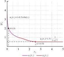
Fig. 2
Weight function curve"


Fig. 3
Sampling strategy comparison results"

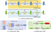
Fig. 4
The network of point cloud feature extraction"
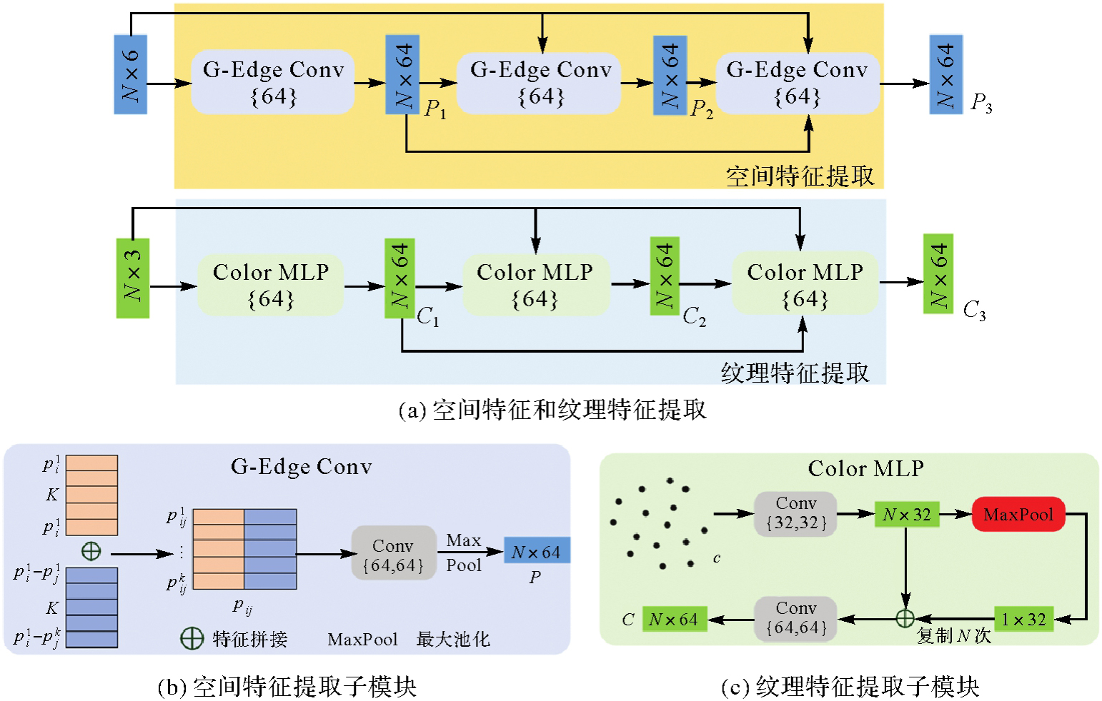
Fig. 5
Structure extraction based on fused features"

Tab. 1
Information of experimental datasets"
| 墙面 | 示例 | 点数 | 立面结构 | 墙面特点 |
|---|---|---|---|---|
| 1 |  | 215 465 | 墙、门、窗户 | 点云缺失、墙面不完整 |
| 2 |  | 287 161 | 墙、门、窗户、空调外机 | 多样结构,墙面完整 |
| 3 |  | 297 361 | 墙、窗户 | 墙面完整,结构简单 |
| 4 |  | 221 184 | 墙、阳台 | 点云缺失,结构不完整 |
| 5 |  | 445 910 | 墙、窗户、门 | 结构复杂规整,墙面完整 |
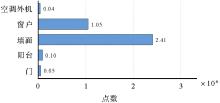
Fig. 6
The number of points in each structure"

Tab. 2
Structure extraction accuracy"
| 墙面 | OA | mAcc | IoU | mIoU | ||||
|---|---|---|---|---|---|---|---|---|
| 窗户 | 墙 | 阳台 | 空调外机 | 门 | ||||
| 1 | 94.43 | 94.17 | 89.38 | 90.22 | — | 87.29 | — | 88.96 |
| 2 | 98.78 | 95.80 | — | 98.41 | 95.21 | — | — | 97.41 |
| 3 | 95.39 | 91.20 | 98.19 | 98.24 | — | — | 90.07 | 95.50 |
| 4 | 98.59 | 93.22 | — | 98.16 | 95.78 | — | 92.64 | 96.66 |
| 5 | 99.03 | 98.90 | 98.67 | 97.72 | — | — | 91.80 | 96.53 |
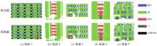
Fig. 7
The results of visualize extraction"

Tab. 3
Comparison of extraction accuracy"
| 方法 | OA | mAcc | IoU | mIoU | ||||
|---|---|---|---|---|---|---|---|---|
| 窗户 | 墙 | 阳台 | 空调外机 | 门 | ||||
| PointNet[ | 61.25 | 48.26 | 69.80 | 55.60 | 39.40 | 6.80 | 33.40 | 41.00 |
| PointNet++[ | 78.58 | 70.97 | 86.40 | 79.70 | 59.70 | 5.10 | 47.90 | 55.76 |
| R-DGCNN[ | 97.31 | 92.25 | 94.41 | 96.39 | 93.35 | 88.55 | 70.30 | 88.60 |
| DLA-Net[ | 98.72 | 96.56 | 95.65 | 97.51 | 91.60 | 87.96 | 71.13 | 88.97 |
| PCF-Net(本文方法) | 97.99 | 97.80 | 92.75 | 96.88 | 95.41 | 95.72 | 97.99 | 95.75 |
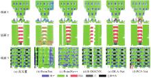
Fig. 8
The building face structure extraction results"

Tab. 4
Comparison of experimental results"
| 方案 | Color MLP | 点云权重采样 | Lovsz-Softmax | 加权交叉熵 | IoU | mIoU | ||||
|---|---|---|---|---|---|---|---|---|---|---|
| 窗户 | 墙 | 阳台 | 空调外机 | 门 | ||||||
| 1 | — | — | — | — | 94.21 | 96.19 | 93.15 | 88.35 | 70.10 | 87.60 |
| 2 | √ | — | — | — | 93.64 | 95.34 | 92.33 | 89.06 | 73.17 | 88.71 |
| 3 | √ | √ | — | — | 93.78 | 96.72 | 93.56 | 90.32 | 76.52 | 89.51 |
| 4 | √ | √ | √ | — | 94.80 | 96.15 | 92.57 | 95.49 | 80.39 | 91.88 |
| 5 | √ | √ | √ | √ | 92.75 | 96.88 | 95.41 | 95.72 | 97.99 | 95.75 |
| [1] |
杨必胜, 陈驰, 董震. 面向智能化测绘的城市地物三维提取[J]. 测绘学报, 2022, 51(7): 1476-1484. DOI: .
doi: 10.11947/j.AGCS.2022.20220183 |
|
YANG Bisheng, CHEN Chi, DONG Zhen. 3D geospatial information extraction of urban objects for smart surveying and mapping[J]. Acta Geodaetica et Cartographica Sinica, 2022, 51(7): 1476-1484. DOI: .
doi: 10.11947/j.AGCS.2022.20220183 |
|
| [2] | CHEN Chi, JIN Ang, WANG Zhiye, et al. SGSR-net: structure semantics guided LiDAR super-resolution network for indoor LiDAR SLAM[J]. IEEE Transactions on Multimedia, 2024, 26: 1842-1854. |
| [3] | WANG Wei, XU Yuan, REN Yingchao, et al. Parsing of urban facades from 3D point clouds based on a novel multi-view domain[J]. Photogrammetric Engineering & Remote Sensing, 2021, 87(4): 283-293. |
| [4] |
蒋腾平, 王永君, 张林淇, 等. 融合CNN和MRF的激光点云层次化语义分割方法[J]. 测绘学报, 2021, 50(2): 215-225. DOI: .
doi: 10.11947/j.AGCS.2021.20200095 |
|
JIANG Tengping, WANG Yongjun, ZHANG Linqi, et al. A LiDAR point cloud hierarchical semantic segmentation method combining CNN and MRF[J]. Acta Geodaetica et Cartographica Sinica, 2021, 50(2): 215-225. DOI: .
doi: 10.11947/j.AGCS.2021.20200095 |
|
| [5] | XIE Yuxing, TIAN Jiaojiao, ZHU Xiaoxiang. Linking points with labels in 3D: a review of point cloud semantic segmentation[J]. IEEE Geoscience and remote sensing magazine, 2020, 8(4): 38-59. |
| [6] | 张瑞菊, 郑少开, 尹建英. 建筑物立面点云语义分割方法研究[J]. 城市勘测, 2017(5): 22-25. |
| ZHANG Ruiju, ZHENG Shaokai, YIN Jianying. Building facade point cloud semantic segmentation method research[J]. Urban Geotechnical Investigation & Surveying, 2017(5): 22-25. | |
| [7] | 费鲜芸, 戴哲, 刘如飞. 三维激光点云中建筑物立面边界特征提取方法[J]. 山东科技大学学报(自然科学版), 2022, 41(2): 21-30. |
| FEI Xianyun, DAI Zhe, LIU Rufei. Boundary feature extraction method of building facade in 3D laser point cloud[J]. Journal of Shandong University of Science and Technology (Natural Science), 2022, 41(2): 21-30. | |
| [8] | HU Zengtian, CHEN Chi, YANG Bisheng, et al. Geometric feature enhanced line segment extraction from large-scale point clouds with hierarchical topological optimization[J]. International Journal of Applied Earth Observation and Geoinformation, 2022, 112(1): 102858-102868. |
| [9] | 邹纪伟, 刘德儿, 杨鹏, 等. 建筑立面点云对偶深度图像中窗户提取方法[J]. 激光与红外, 2020, 50(7): 875-881. |
| ZOU Jiwei, LIU Deer, YANG Peng, et al. Window extraction method in dual depth image of point cloud of building facade[J]. Laser & Infrared, 2020, 50(7): 875-881. | |
| [10] | ZHAO Fuqun, HUANG He, XIAO Nana, et al. A point cloud segmentation algorithm based on multi-feature training and weighted random forest[J]. Measurement Science and Technology, 2024, 36(1): 015407. |
| [11] | NI Huan, LIN Xiangguo, ZHANG Jixian. Classification of ALS point cloud with improved point cloud segmentation and random forests[J]. Remote Sensing, 2017, 9(3): 288-296. |
| [12] | CHEN Chao, LI Xiaomin, BELKACEM A N, et al. The mixed kernel function SVM-based point cloud classification[J]. International Journal of Precision Engineering and Manufacturing, 2019, 20: 737-747. |
| [13] |
王丽英, 吴际, 有泽, 等. 多维GMM与邻域约束的多光谱机载LiDAR数据城市地物分类. 测绘学报, 2023, 52(3), 419-431. DOI: .
doi: 10.11947/j.AGCS.2023.20210153 |
|
WANG Liying, WU Ji, YOU Ze, et al. Urban object classification of multispectral airborne LiDAR data with multi-dimensional Gauss mixture model and neighborhood constraints[J]. Acta Geodaetica et Cartographica Sinica, 2023, 52(3): 419-431. DOI: .
doi: 10.11947/j.AGCS.2023.20210153 |
|
| [14] |
BALLOUCH Z, HAJJI R, POUX F, et al. A prior level fusion approach for the semantic segmentation of 3D point clouds using deep learning[J]. Remote Sensing, 2022, 14(14): 3415. DOI: .
doi: doi.org/10.3390/rs14143415 |
| [15] | DAI Menglin, WARD W O C, MEYERS G, et al. Residential building facade segmentation in the urban environment[J]. Building and Environment, 2021, 199: 107921. |
| [16] | WANG Puzuo, YAO Wei. A new weakly supervised approach for ALS point cloud semantic segmentation[J]. ISPRS Journal of Photogrammetry and Remote Sensing, 2022, 188: 237-254. DOI: https://doi.org/10.1016/j.isprsjprs.2022.04.016. |
| [17] | CHEN Dong, XIANG Guiqiu, PEETHAMBARAN J, et al. AFGL-net: attentive fusion of global and local deep features for building façades parsing[J]. Remote Sensing, 2021, 13(24): 5039. |
| [18] | HU Qingyong, YANG Bo, XIE Linkai, et al. RanDLA-net: efficient semantic segmentation of large-scale point clouds[C]//Proceedings of the IEEE/CVF conference on computer vision and pattern recognition. [EB/OL]: IEEE, 2020: 11108-11117. |
| [19] | SU Yanfei, LIU Weiquan, YUAN Zhimin, et al. DLA-Net: learning dual local attention features for semantic segmentation of large-scale building facade point clouds[J]. Pattern Recognition, 2022, 123: 108372. |
| [20] | ZHANG Xinlong, LIN Dong, SOERGEL U. Target-aware attentional network for rare class segmentation in large-scale LiDAR point clouds[J]. ISPRS Journal of Photogrammetry and Remote Sensing, 2025, 220(1): 32-50. DOI: https://doi.org/10.1016/j.isprsjprs.2024.11.012. |
| [21] |
方莉娜, 沈贵熙, 游志龙, 等. 融合点云和多视图的车载激光点云路侧多目标识别[J]. 测绘学报, 2021, 50(11): 1558-1573. DOI: .
doi: 10.11947/j.AGCS.2021.20210246 |
|
FANG Lina, SHEN Guixi, YOU Zhi, et al. A joint network of point cloud and multiple views for recognition from mobile laser point clouds[J]. Acta Geodaetica et Cartographica Sinica, 2021, 50(11): 1558-1573. DOI: .
doi: 10.11947/j.AGCS.2021.20210246 |
|
| [22] | ZANG Yufu, WANG Shuye, GUAN Haiyan, et al. VAM-Net: vegetation-attentive deep network for multi-modal fusion of visible-light and vegetation-sensitive images[J]. International Journal of Applied Earth Observation and Geoinformation, 2024, 127: 103642. |
| [23] | YU Bing, HU Jinlong, DONG Xiujun, et al. A robust automatic method to extract building facade maps from 3D point cloud data[J]. Remote Sensing, 2022, 14(16): 3848. |
| [24] |
WANG Y, SUN Y, LIU Z, et al. Dynamic graph cnn for learning on point clouds[J]. ACM Transactions on Graphics (tog), 2019, 38(5), 1-12. DOI: .
doi: 10.48550/arXiv.1801.07829 |
| [25] | MORBIDONI C, PIERDICCA R, QUATTRINI R, et al. Graph cnn with radius distance for semantic segmentation of historical buildings TLS point clouds[J]. The International Archives of the Photogrammetry, Remote Sensing and Spatial Information Sciences, 2020, XLIV-4/W1-2020: 95-102. |
| [26] | 陈科, 管海燕, 雷相达, 等. 基于特征增强核点卷积网络的多光谱LiDAR点云分类方法[J]. 地球信息科学学报, 2023, 25(5): 1075-1087. |
| CHEN Ke, GUAN Haiyan, LEI Xiangda, et al. A multispectral LiDAR point cloud classification method based on enhanced features kernel point convolutional network[J]. Journal of Geo-information Science, 2023, 25(5): 1075-1087. | |
| [27] | 高建文, 管海燕, 彭代锋, 等. 基于局部-全局语义特征增强的遥感影像变化检测网络模型[J]. 地球信息科学学报, 2023, 25(3): 625-637. |
| GAO Jianwen, GUAN Haiyan, PENG Daifeng, et al. Local-global semantic feature enhancement model for remote sensing imagery change detection[J]. Journal of Geo-information Science, 2023, 25(3): 625-637. | |
| [28] | QI C R, SU H, MO K, et al. Pointnet: deep learning on point sets for 3D classification and segmentation[J]. Proceedings of the IEEE Conference on Computer Vision and Pttern Recognition, 2017(1): 652-660. |
| [29] | QI C R, YI Li, SU Hao, et al. PointNet++: deep hierarchical feature learning on point sets in a metric space[EB/OL]. [2024-10-16]. https://arxiv.org/abs/1706.02413v1. |
| [1] | Daifeng PENG, Xuelian LIU, Mengfei LU, Haiyan GUAN. Heterogeneous remote sensing image flood change detection based on multi-scale cross-modal feature fusion [J]. Acta Geodaetica et Cartographica Sinica, 2026, 55(2): 328-343. |
| [2] | Zibo DONG, Jingxue WANG, Lijing BU, Lin FANG, Zhenghui XU. MAFNet: building extraction method from remote sensing images based on multi-scale atrous fusion network [J]. Acta Geodaetica et Cartographica Sinica, 2025, 54(6): 1094-1106. |
| [3] | Guangao XING, Guanming LU, Bin HAN. MAFUNet: water body segmentation algorithm for SAR images combining attention mechanisms and active contour loss [J]. Acta Geodaetica et Cartographica Sinica, 2025, 54(5): 924-936. |
| [4] | Jun ZHU, Jianlin WU, Zhilin LI, Yukun GUO, Jigang YOU, Yakun XIE, Weilian LI. The technological advancements in 3D mapping abroad [J]. Acta Geodaetica et Cartographica Sinica, 2025, 54(4): 661-674. |
| [5] | LIANG Zheheng, LI Xiao, DENG Peng, SHENG Sen, JIANG Fuquan. Remote sensing image change detection fusion method integrating multi-scale feature attention [J]. Acta Geodaetica et Cartographica Sinica, 2022, 51(5): 668-676. |
| [6] | JIA Junhui, HUANG Ming, LIU Xianglei. Surface Reconstruction Algorithm Based on 3D Delaunay Triangulation [J]. Acta Geodaetica et Cartographica Sinica, 2018, 47(2): 281-290. |
| [7] | . Vector Based Sparse Depth Map Algorithm [J]. Acta Geodaetica et Cartographica Sinica, 2011, 40(1): 90-95. |
| Viewed | ||||||
|
Full text |
|
|||||
|
Abstract |
|
|||||