

Acta Geodaetica et Cartographica Sinica ›› 2025, Vol. 54 ›› Issue (5): 924-936.doi: 10.11947/j.AGCS.2025.20240235
• Photogrammetry and Remote Sensing • Previous Articles Next Articles
Guangao XING( ), Guanming LU, Bin HAN()
Received:2024-06-04
Revised:2025-04-10
Online:2025-06-23
Published:2025-06-23
Contact:
Bin HAN
E-mail:guangaoxing1215@163.com;njupt.bh@foxmail.com
About author:XING Guangao (1999—), male, postgraduate, majors in remote sensing image processing. E-mail: guangaoxing1215@163.com
Supported by:CLC Number:
Guangao XING, Guanming LU, Bin HAN. MAFUNet: water body segmentation algorithm for SAR images combining attention mechanisms and active contour loss[J]. Acta Geodaetica et Cartographica Sinica, 2025, 54(5): 924-936.
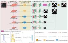
Fig. 1
Overall structure of MAFUNet"

Tab. 1
Detailed information about MAFUNet encoders"
| 层 | 输入 | 输出 | 结构 |
|---|---|---|---|
| Conv 0 | 3×256×256 | 64×256×256 | (3×3Conv+BN+ReLU)×2 |
| Layer 1 | 64×256×256 | 64×128×128 | 7×7Conv+BN+ReLU |
| Layer 2 | 64×128×128 | 64×64×64 | 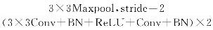 |
| Layer 3 | 64×64×64 | 128×32×32 | 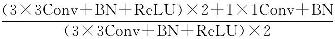 |
| Layer 4 | 128×32×32 | 256×16×16 | 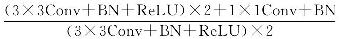 |
| Layer 5 | 256×16×16 | 512×8×8 | 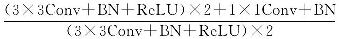 |
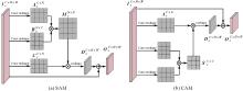
Fig. 2
Detailed calculation process for SAM and CAM modules"
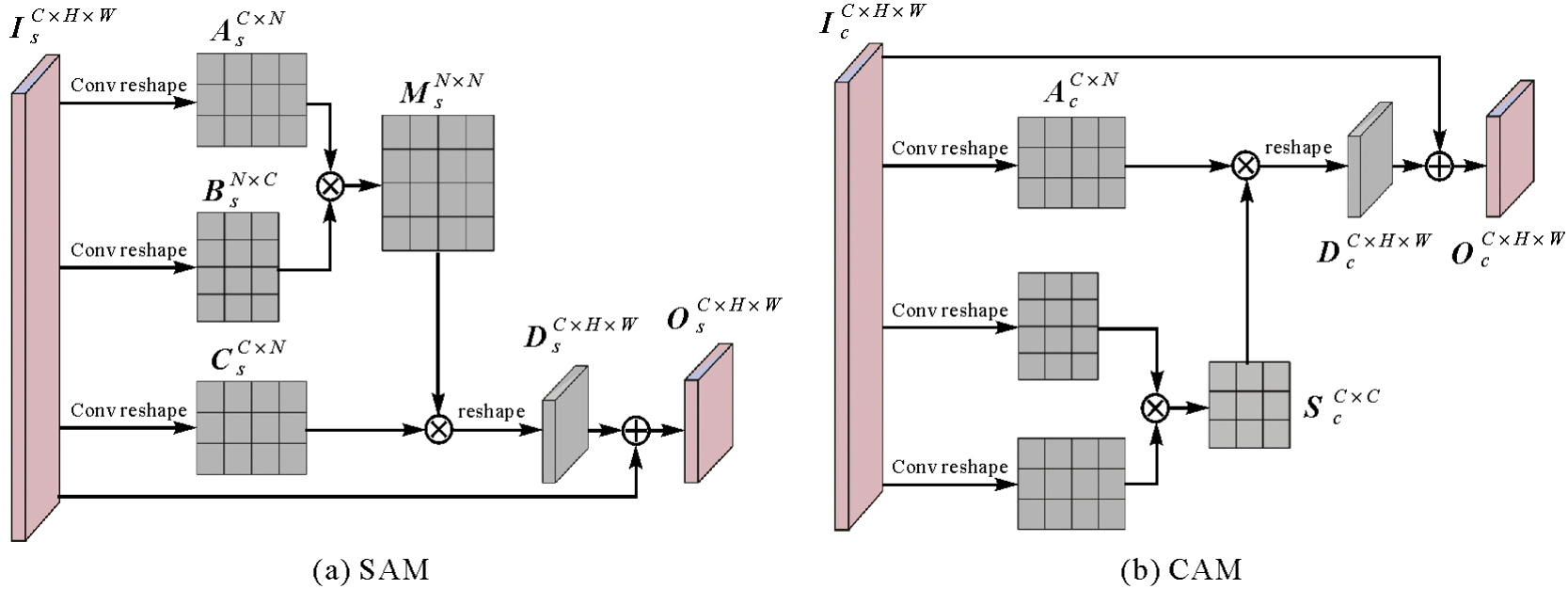
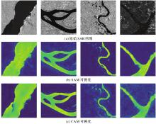
Fig. 3
Visual presentation of SAR images through SAM and CAM"
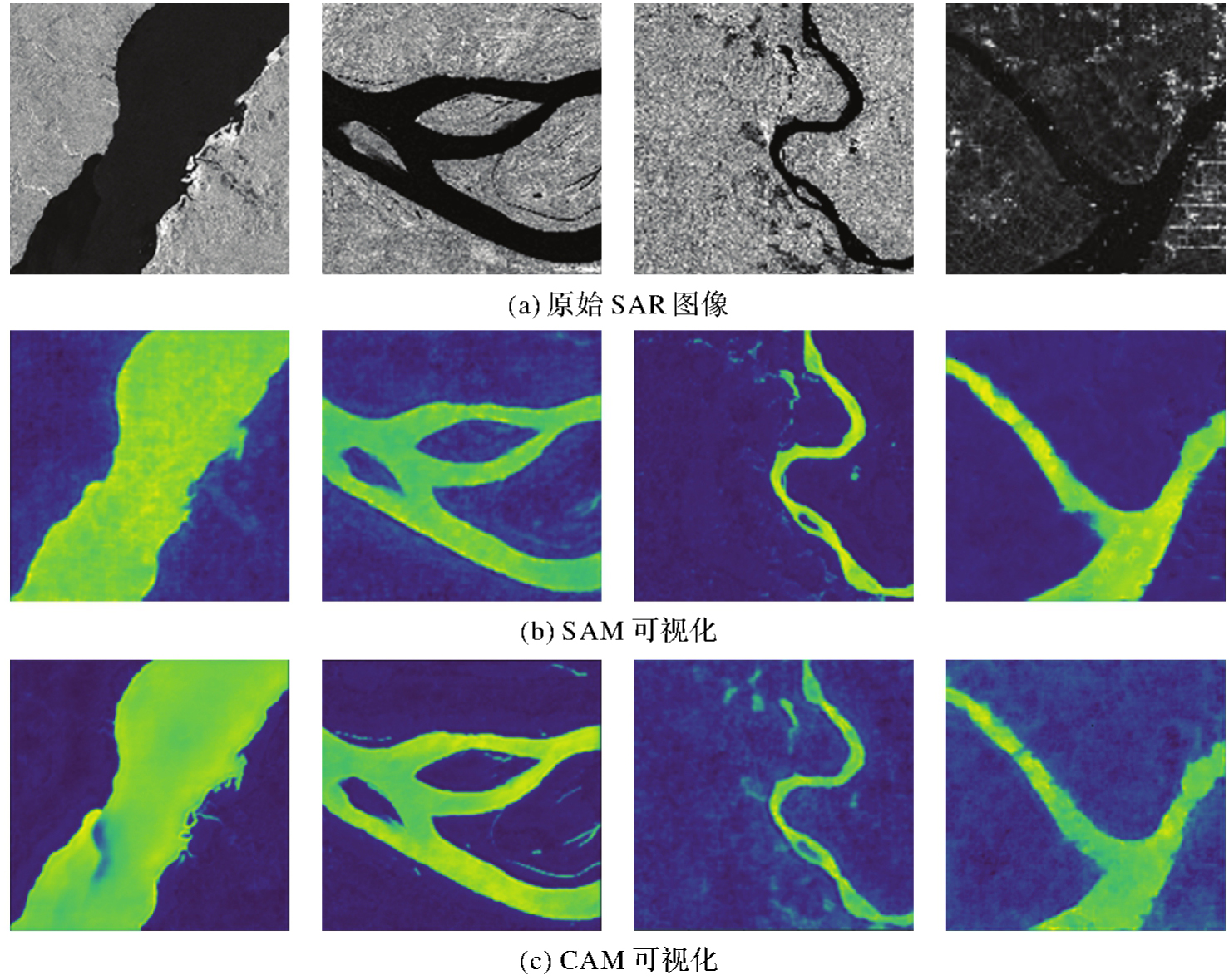
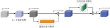
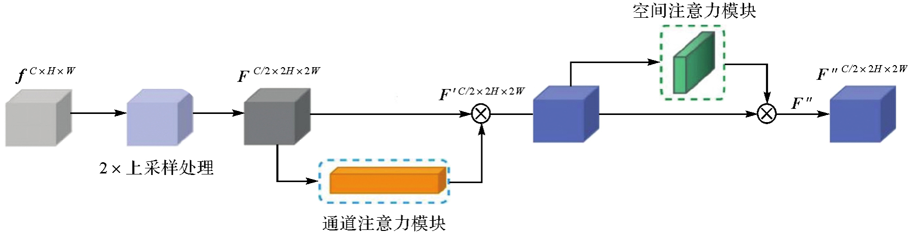
Fig. 4
Architecture of the attention upsampler of the decoder"
Tab. 2
The specific divisions of ALOS PALSAR dataset"
| 数据集划分 | 数据集 | 样本数量 | 图像尺寸 |
|---|---|---|---|
| 训练集 | 1413 | 256×256 | |
| 验证集 | ALOS PALSAR | 706 | 256×256 |
| 测试集 | 235 | 256×256 |
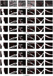
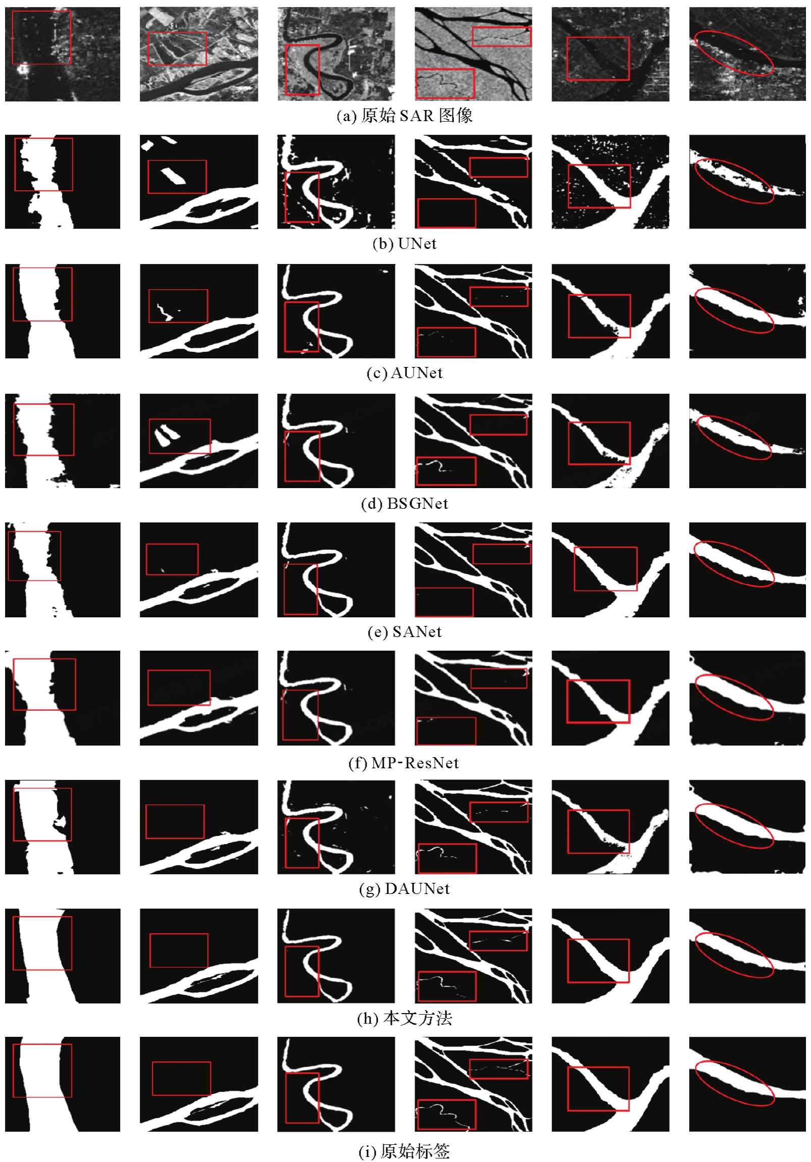
Fig. 5
The visualization results of water body detection in SAR images of ALOS PALSAR dataset with different methods"
Tab. 3
Performance comparison of different methods on ALOS PALSAR dataset"
| 模型 | OA | Pre | R | IoU | F1值 |
|---|---|---|---|---|---|
| UNet | 88.51 | 87.53 | 88.52 | 89.22 | 88.02 |
| AUNet | 88.01 | 89.09 | 90.92 | 91.15 | 90.01 |
| BSGNet | 88.89 | 88.45 | 89.56 | 90.32 | 89.00 |
| SANet | 93.34 | 92.02 | 92.35 | 92.35 | 92.18 |
| MP-ResNet | 93.56 | 92.78 | 92.68 | 92.56 | 92.45 |
| DAUNet | 94.04 | 93.02 | 93.13 | 92.41 | 93.08 |
| MAFUNet | 97.23 | 97.69 | 97.66 | 94.28 | 97.67 |
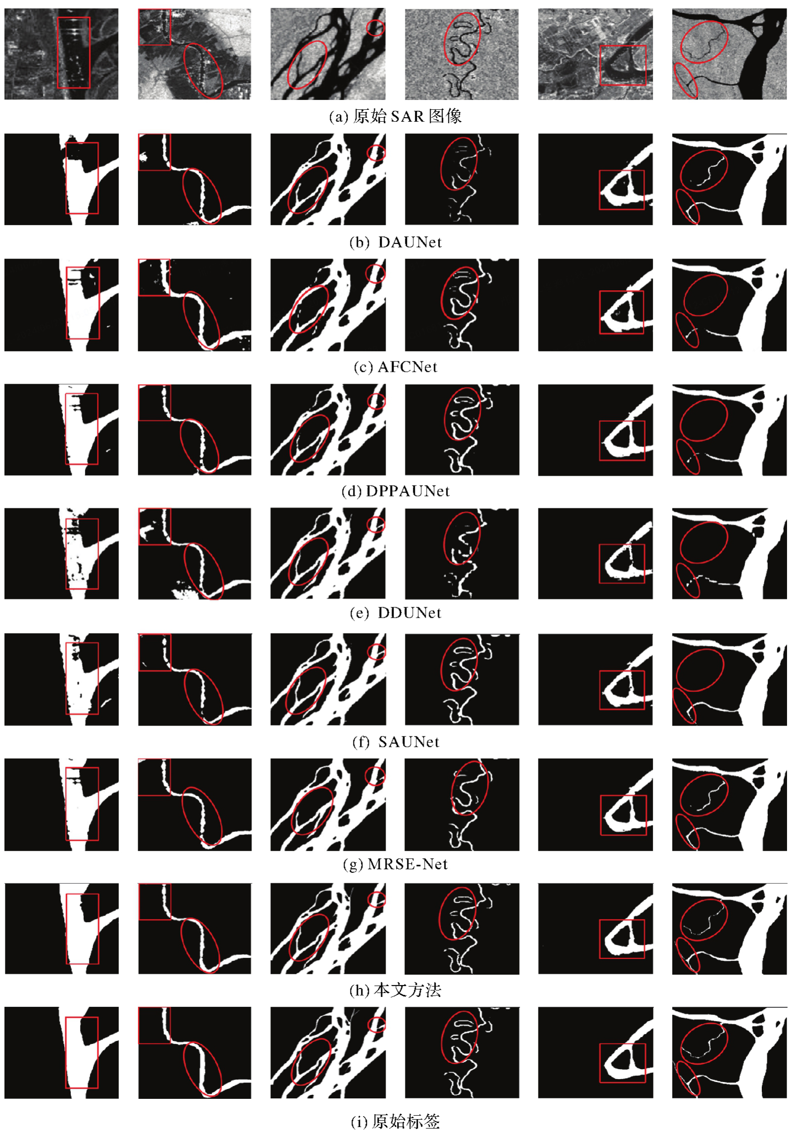
Fig. 6
Detection results of various networks with attention modules on ALOS PALSAR dataset"
Tab. 4
Performance comparison with models of other attention mechanisms based on ALOS PALSAR dataset"
| 模型 | OA | Pre | R | IoU | F1值 |
|---|---|---|---|---|---|
| DAUNet | 94.04 | 93.02 | 93.13 | 92.41 | 93.08 |
| AFCNet | 93.68 | 91.78 | 91.26 | 91.47 | 91.51 |
| DPPAUNet | 94.23 | 93.85 | 92.62 | 92.22 | 93.23 |
| DDUNet | 93.62 | 91.21 | 91.63 | 90.42 | 91.41 |
| SAUNet | 96.23 | 94.52 | 93.26 | 92.63 | 93.88 |
| MRSE-Net | 96.63 | 94.25 | 94.33 | 93.62 | 94.29 |
| MAFUNet | 97.23 | 97.69 | 97.66 | 94.28 | 97.67 |
Tab. 5
Ablation experiments based on AC loss"
| (α1,β1) | IoU | F1值 |
|---|---|---|
| (0,1) | 91.68 | 94.23 |
| (0.25,0.75) | 92.88 | 96.43 |
| (0.5,0.5) | 92.72 | 95.73 |
| (0.75,0.25) | 92.65 | 95.56 |
| (1,0) | 90.68 | 93.02 |
Tab. 6
Performance comparison of decoders with different attention modules"
| 网络 | IoU | F1值 |
|---|---|---|
| MAFUNet+SENet | 92.88 | 96.35 |
| MAFUNet+SKNet | 93.15 | 96.52 |
| MAFUNet+CBAM(本文方法) | 94.28 | 97.67 |
Tab. 7
Results of ablation experiments based on ALOS PALSAR dataset"
| 网络 | OA | Pre | R | IoU | F1值 |
|---|---|---|---|---|---|
| Baseline | 93.36 | 94.87 | 93.92 | 92.02 | 94.39 |
| Baseline+SA+CA | 93.55 | 95.78 | 95.13 | 92.53 | 95.45 |
| Baseline+AU | 93.75 | 95.82 | 95.65 | 92.64 | 95.73 |
| Baseline+MCPB | 94.88 | 96.34 | 95.28 | 92.48 | 95.80 |
| Baseline+SA+CA+AU | 95.08 | 96.45 | 95.78 | 92.82 | 96.11 |
| MAFUNet | 97.23 | 97.69 | 97.66 | 94.28 | 97.67 |
Tab. 8
Performance comparison with different loss functions"
| 网络 | IoU | F1值 |
|---|---|---|
| Baseline+BCE | 90.32 | 92.86 |
| Baseline+BCE+Dice | 91.64 | 93.32 |
| Baseline+BCE+AC | 92.02 | 94.39 |
| MAFUNet+BCE | 92.63 | 96.76 |
| MAFUNet+BCE+Dice | 93.35 | 6.78 |
| MAFUNet+BCE+AC | 94.28 | 97.67 |
| (本文方法) |
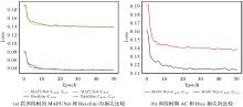
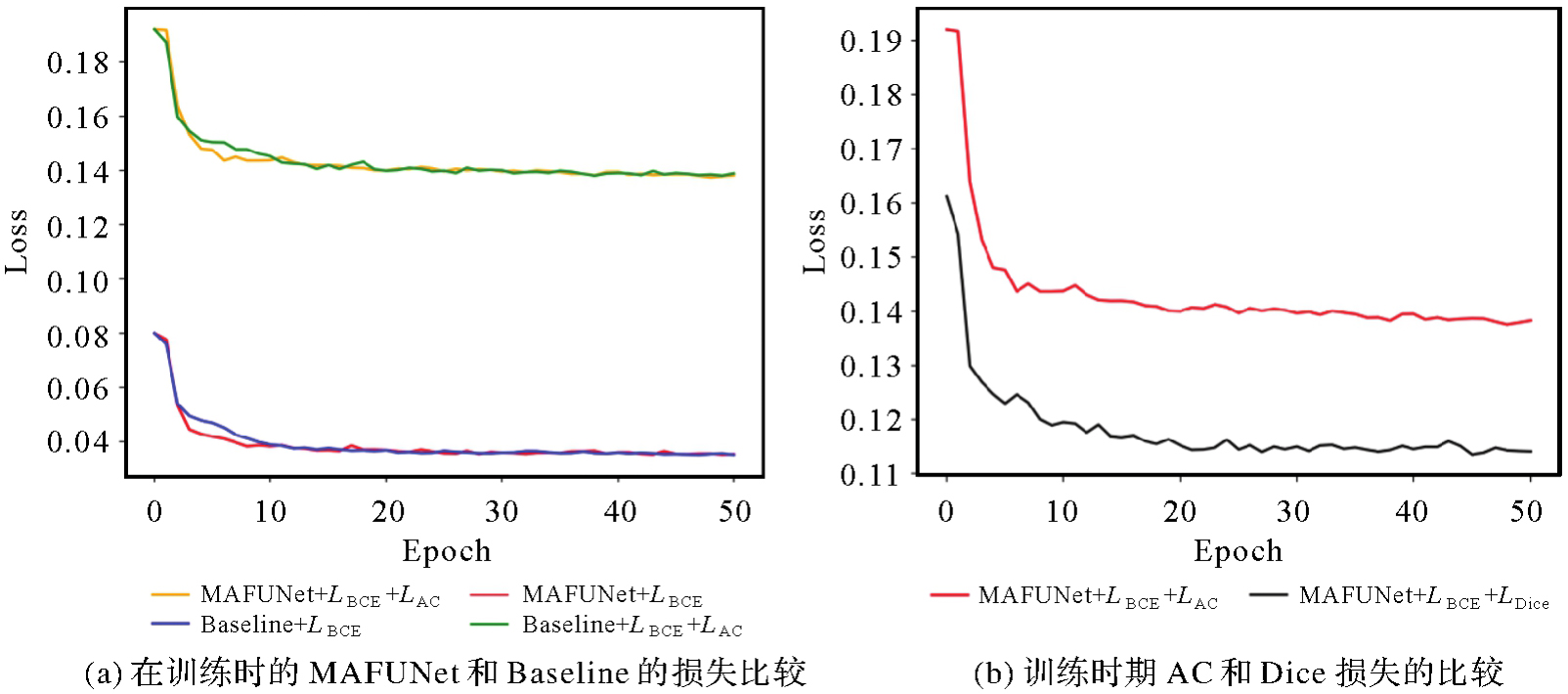
Fig. 7
Discussion of MAFUNet and Baseline with different losses in the training epoch"
| [1] | ZHAO Bofei, SUI Haigang, ZHU Yihao, et al. Real-time rescue target detection based on UAV imagery for flood emergency response[J]. Journal of Geodesy and Geoinformation Science, 2024, 7(1): 74-89. |
| [2] |
韩斌, 吴一全. SAR图像河流提取的主动轮廓模型的稳健估计算法[J]. 测绘学报, 2020, 49(6): 777-786. DOI .
doi: 10.11947/j.AGCS.2020.20180423 |
|
HAN Bin, WU Yiquan. Robust estimation algorithm of active contour model for river extraction in SAR images[J]. Acta Geodaetica et Cartographica Sinica, 2020, 49(6): 777-786. DOI .
doi: 10.11947/j.AGCS.2020.20180423 |
|
| [3] |
杨蕴, 李玉, 赵泉华. 斑点抑制与多分辨率拓扑分析相结合的SAR图像河流水体提取[J]. 测绘学报, 2022, 51(1): 145-158. DOI .
doi: 10.11947/j.AGCS.2022.20190395 |
|
YANG Yun, LI Yu, ZHAO Quanhua. River waterbody extraction from SAR images based on speckle reduction and multi-resolution topological analysis[J]. Acta Geodaetica et Cartographica Sinica, 2022, 51(1): 145-158. DOI .
doi: 10.11947/j.AGCS.2022.20190395 |
|
| [4] | 吴庆双, 汪明秀, 申茜, 等. Sentinel-2遥感图像的细小水体提取[J]. 遥感学报, 2022, 26(4): 781-794. |
| WU Qingshuang, WANG Mingxiu, SHEN Qian, et al. Small water body extraction method based on Sentinel-2 satellite multi-spectral remote sensing image[J]. National Remote Sensing Bulletin, 2022, 26(4): 781-794. | |
| [5] | LONG J, SHELHAMER E, DARRELL T. Fully convolutional networks for semantic segmentation[C]//Proceedings of 2015 IEEE Conference on Computer Vision and Pattern Recognition. Boston: IEEE, 2015: 3431-3440. |
| [6] | RONNEBERGER O, FISCHER P, BROX T. U-Net: convolutional networks for biomedical image segmentation[C]//Proceedings of 2015 Medical Image Computing and Computer-Assisted Intervention. Cham: Springer International Publishing, 2015: 234-241. |
| [7] | BADRINARAYANAN V, KENDALL A, CIPOLLA R. SegNet: a deep convolutional encoder-decoder architecture for image segmentation[J]. IEEE Transactions on Pattern Analysis and Machine Intelligence, 2017, 39(12): 2481-2495. |
| [8] | CHEN L C, PAPANDREOU G, KOKKINOS I, et al. Semantic image segmentation with deep convolutional nets and fully connected CRFs[EB/OL]. [2024-03-06]. https://arxiv.org/abs/1412.7062v4. |
| [9] | CHEN L C, ZHU Yukun, PAPANDREOU G, et al. Encoder-decoder with atrous separable convolution for semantic image segmentation[C]//Proceedings of 2018 ECCV. Cham: Springer International Publishing, 2018: 833-851. |
| [10] | KIM M U, OH H, LEE S J, et al. Deep learning based water segmentation using KOMPSAT-5 SAR images[C]//Proceedings of 2021 IEEE International Geoscience and Remote Sensing Symposium IGARSS. Brussels: IEEE, 2021: 4055-4058. |
| [11] | ZHAO Hengshuang, SHI Jianping, QI Xiaojuan, et al. Pyramid scene parsing network[C]//Proceedings of 2017 IEEE Conference on Computer Vision and Pattern Recognition. Honolulu: IEEE, 2017: 6230-6239. |
| [12] | LI Juanjuan, WANG Chao, XU Lu, et al. Multitemporal water extraction of Dongting Lake and Poyang Lake based on an automatic water extraction and dynamic monitoring framework[J]. Remote Sensing, 2021, 13(5): 865. |
| [13] | DIRSCHERL M, DIETZ A J, KNEISEL C, et al. A novel method for automated supraglacial lake mapping in Antarctica using Sentinel-1 SAR imagery and deep learning[J]. Remote Sensing, 2021, 13(2): 197. |
| [14] | ZHANG Jinsong, XING Mengdao, SUN Guangcai, et al. Water body detection in high-resolution SAR images with cascaded fully-convolutional network and variable focal loss[J]. IEEE Transactions on Geoscience and Remote Sensing, 2021, 59(1): 316-332. |
| [15] | REN Yibin, LI Xiaofeng, YANG Xiaofeng, et al. Development of a dual-attention U-Net model for sea ice and open water classification on SAR images[J]. IEEE Geoscience and Remote Sensing Letters, 2022, 19: 4010205. |
| [16] |
胡功明, 杨春成, 徐立, 等. 改进U-Net的遥感图像语义分割方法[J]. 测绘学报, 2023, 52(6): 980-989. DOI .
doi: 10.11947/j.AGCS.2023.20210684 |
|
HU Gongming, YANG Chuncheng, XU Li, et al. Improved U-Net remote sensing image semantic segmentation method[J]. Acta Geodaetica et Cartographica Sinica, 2023, 52(6): 980-989. DOI .
doi: 10.11947/j.AGCS.2023.20210684 |
|
| [17] |
韩斌, 吴一全. SAR图像河流分割的加权指数区域能量模型[J]. 测绘学报, 2017, 46(9): 1174-1181. DOI .
doi: 10.11947/j.AGCS.2017.20170134 |
|
HAN Bin, WU Yiquan. Weighted exponential region energy model for river segmentation of SAR images[J]. Acta Geodaetica et Cartographica Sinica, 2017, 46(9): 1174-1181. DOI .
doi: 10.11947/j.AGCS.2017.20170134 |
|
| [18] | TORRALBA A, RUSSELL B C, YUEN J. LabelMe: online image annotation and applications[J]. Proceedings of the IEEE, 2010, 98(8): 1467-1484. |
| [19] | OKTAY O, SCHLEMPER J, LE FOLGOC L, et al. Attention U-Net: learning where to look for the pancreas[EB/OL]. [2024-03-06]. https://arxiv.org/abs/1804.03999v3. |
| [20] | YU Jie, CAI Yang, LYU Xin, et al. Boundary-guided semantic context network for water body extraction from remote sensing images[J]. Remote Sensing, 2023, 15(17): 4325. |
| [21] | XU Ming, LI Hongping, YUN Yuying, et al. End-to-end pixel-wisely detection of oceanic eddy on SAR images with stacked attention network[J]. IEEE Journal of Selected Topics in Applied Earth Observations and Remote Sensing, 2023, 16: 9711-9724. |
| [22] | DING Lei, ZHENG Kai, LIN Dong, et al. MP-ResNet: multipath residual network for the semantic segmentation of high-resolution PolSAR images[J]. IEEE Geoscience and Remote Sensing Letters, 2022, 19: 4014205. |
| [23] | YUE Zhenyu, GAO Fei, XIONG Qingxu, et al. A novel attention fully convolutional network method for synthetic aperture radar image segmentation[J]. IEEE Journal of Selected Topics in Applied Earth Observations and Remote Sensing, 2020, 13: 4585-4598. |
| [24] | PAN Bin, SHI Xianjian. Fusing ascending and descending time-series SAR images with dual-polarized pixel attention UNet for landslide recognition[J]. Remote Sensing, 2023, 15(23): 5619. |
| [25] | WANG Ying, PENG Yuexing, LI Wei, et al. DDU-Net: dual-decoder-U-net for road extraction using high-resolution remote sensing images[J]. IEEE Transactions on Geoscience and Remote Sensing, 2022, 60: 1-12. |
| [26] | FAN Xiangsuo, YAN Chuan, FAN Jinlong, et al. Improved U-Net remote sensing classification algorithm fusing attention and multiscale features[J]. Remote Sensing, 2022, 14(15): 3591. |
| [27] | ZHANG Xinyu, LI Jinjiang, HUA Zhen. MRSE-Net: multiscale residuals and SE-attention network for water body segmentation from satellite images[J]. IEEE Journal of Selected Topics in Applied Earth Observations and Remote Sensing, 2022, 15: 5049-5064. |
| [28] | HU Jie, SHEN Li, SUN Gang. Squeeze-and-excitation networks[C]//Proceedings of 2018 IEEE/CVF Conference on Computer Vision and Pattern Recognition. Salt Lake City: IEEE, 2018: 7132-7141. |
| [29] | LI Xiang, WANG Wenhai, HU Xiaolin, et al. Selective kernel networks[C]//Proceedings of 2019 IEEE/CVF Conference on Computer Vision and Pattern Recognition. Long Beach: IEEE, 2019: 510-519. |
| [30] | 付相为, 单慧琳, 吕宗奎, 等. 基于深度学习的合成孔径雷达图像去噪算法[J]. 光学学报, 2023, 43(6): 0610002. |
| FU Xiangwei, SHAN Huilin, LÜ Zongkui, et al. Synthetic aperture radar image denoising algorithm based on deep learning[J]. Acta Optica Sinica, 2023, 43(6): 0610002. |
| [1] | Hongmei WANG, Lihua WANG, Benhua TAN, Xiaoyi JIANG, Lili SONG, Weiwei SUN. SAR high-precision inversion of sea surface current over offshore China [J]. Acta Geodaetica et Cartographica Sinica, 2026, 55(4): 588-603. |
| [2] | Jingxuan LIU, Xuexi LIU, Kefei ZHANG, Chao YANG, Suqin WU, Shouqing ZHU, Fudong GUO. A prediction method for LOD based on combined LSTM and WLS [J]. Acta Geodaetica et Cartographica Sinica, 2026, 55(3): 477-489. |
| [3] | Zhong LU, Jinqi ZHAO, Yufen NIU, Liquan CHEN, Qianyou FAN, Jinzhao SI, Zixuan WANG, Yuan GAO, Shuai WANG, Feifei QU, Hongtao SHI, Shiyong YAN, Yun SHI, Zheng ZHAO. The NISAR mission: innovations in earth observation and applications in surface deformation monitoring [J]. Acta Geodaetica et Cartographica Sinica, 2026, 55(2): 261-274. |
| [4] | Bin HAN, Xin HUANG, Fengyi LI, Xiaozhen LU. Water body segmentation network for SAR images combining dual-encoder and adaptive feature fuse [J]. Acta Geodaetica et Cartographica Sinica, 2026, 55(1): 101-113. |
| [5] | Peng LI, Jianbo BAI, Zhenhong LI, Houjie WANG. Wide area coastal subsidence monitoring and driver analysis with multi tracks of TS-InSAR—a case study of Shandong province [J]. Acta Geodaetica et Cartographica Sinica, 2025, 54(7): 1178-1191. |
| [6] | Kefu WU, Haiqiang FU, Jianjun ZHU, Qijin HAN, Aichun WANG, Mingxia ZHANG, Zhiwei LI. LT-1 InSAR block adjustment considering the impact of penetration depth in forest areas [J]. Acta Geodaetica et Cartographica Sinica, 2025, 54(6): 1009-1020. |
| [7] | Qingli LUO, Xueyan LI, Guoman HUANG, Honghui CHEN, Minglong XUE, Jian LI. AOSN: alpha optimal structure network for height estimation from a single SAR image in mountain areas [J]. Acta Geodaetica et Cartographica Sinica, 2025, 54(5): 888-898. |
| [8] | Zhaofeng DU, Guopeng LI, Zhanke LIU, Xiaming SHANG, Shengjun KANG, Xiaoqiang WANG. Comprehensive analysis of multiple monitoring methods in main subsidence areas [J]. Acta Geodaetica et Cartographica Sinica, 2025, 54(3): 481-492. |
| [9] | Ziqing WEI. Talk about X-ray pulsar navigation [J]. Acta Geodaetica et Cartographica Sinica, 2025, 54(2): 207-212. |
| [10] | Hongkai SHI, Xiufeng HE, Yihao WU, Xiangtian ZHENG, Minfeng SONG. Waveform contamination identification and accurate sea surface height extraction algorithm for high-frequency fully-focused SAR in severely interfered coastal regions [J]. Acta Geodaetica et Cartographica Sinica, 2025, 54(2): 272-285. |
| [11] | Wei PENG, Jing YANG, Haiqiang FU, Jianjun ZHU, Dong ZENG. UAV-borne repeat-pass InSAR data processing method considering motion error characteristics [J]. Acta Geodaetica et Cartographica Sinica, 2025, 54(11): 1954-1967. |
| [12] | Hailu CHEN, Yunzhong SHEN. GNSS-assisted InSAR tropospheric delay correction model incorporating vertical stratification and turbulent components [J]. Acta Geodaetica et Cartographica Sinica, 2025, 54(10): 1786-1797. |
| [13] | Yibo XING, Bin HAN, Bingkun BAO. River SAR image segmentation using L1 norm based hybrid active contours [J]. Acta Geodaetica et Cartographica Sinica, 2024, 53(8): 1598-1609. |
| [14] | Jichong YIN, Fang WU, Renjian ZHAI, Yue QIU, Xianyong GONG, Ruixing XING. Two-stream boundary constraints and relativistic generation adversarial network for building contour regularization [J]. Acta Geodaetica et Cartographica Sinica, 2024, 53(7): 1444-1457. |
| [15] | Liming JIANG, Yi SHAO, Zhiwei ZHOU, Peifeng MA, Teng WANG. A review of intelligent InSAR data processing: recent advancements, challenges and prospects [J]. Acta Geodaetica et Cartographica Sinica, 2024, 53(6): 1037-1056. |
| Viewed | ||||||
|
Full text |
|
|||||
|
Abstract |
|
|||||