

Acta Geodaetica et Cartographica Sinica ›› 2025, Vol. 54 ›› Issue (10): 1798-1811.doi: 10.11947/j.AGCS.2025.20250189
• Geodesy and Navigation • Previous Articles Next Articles
Xuli TAN1( ), Shanshan LI1(), Zhiyong HUANG2, Zongpeng PAN2,3, Diao FAN1, Hongfa WAN1, Xianyong PEI1, Zhenbang XU1
Received:2025-04-29
Revised:2025-10-15
Online:2025-11-14
Published:2025-11-14
Contact:
Shanshan LI
E-mail:txl101088@163.com;zzy_lili@sina.com
About author:TAN Xuli (1996—), male, PhD candidate, majors in satellite gravimetry. E-mail: txl101088@163.com
Supported by:CLC Number:
Xuli TAN, Shanshan LI, Zhiyong HUANG, Zongpeng PAN, Diao FAN, Hongfa WAN, Xianyong PEI, Zhenbang XU. Construction and analysis of the static gravity field model based on ChiGaM satellite[J]. Acta Geodaetica et Cartographica Sinica, 2025, 54(10): 1798-1811.
Tab. 1
Different prior variance values of piecewise constant acceleration"
| 方案 | σ1值 | σ2值 | σ12值 |
|---|---|---|---|
| 方案1 | 3×10⁻⁸ | 3×10⁻⁸ | 不考虑 |
| 方案2 | 3×10⁻⁸ | 3×10⁻⁸ | 3×10⁻¹⁰ |
| 方案3 | 3×10⁻⁹ | 3×10⁻⁹ | 不考虑 |
| 方案4 | 3×10⁻⁹ | 3×10⁻⁹ | 3×10⁻¹⁰ |
| 方案5 | 3×10⁻⁹ | 3×10⁻⁹ | 3×10-11 |
| 方案6 | 3×10⁻¹⁰ | 3×10⁻¹⁰ | 不考虑 |
| 方案7 | 3×10⁻¹⁰ | 3×10⁻¹⁰ | 3×10-11 |
| 方案8 | 3×10-11 | 3×10-11 | 不考虑 |
| 方案9 | 3×10-11 | 3×10-11 | 3×10-11 |
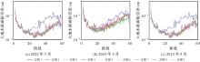
Fig. 1
Geoid degree variance of recovery result based on data using different prior variance values of piecewise constant acceleration"

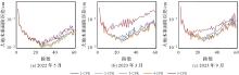
Fig. 2
Geoid degree variance of recovery result based on data by taking into consideration N-CPR terms of KBR empirical parameters"


Fig. 3
Geoid degree variances of solutions before and after empirical eliminating data in several days"

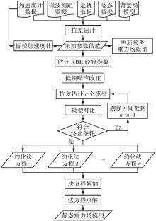
Fig. 4
The process of static gravity field model construction"

Tab. 2
Background models used in the static gravity field model construction"
| 背景场 | 模型 | 描述 |
|---|---|---|
| 地球重力场 | EIGEN-6C4[ | 截断至360阶 |
| 海洋潮汐 | FES2014b[ | 截断至180阶,包含34个主潮汐和327个次潮汐分量,基于导纳理论内插次潮汐分量 |
| 固体潮汐 | IERS convention 2010[ | 考虑至4阶项,同时顾及频率相关项和频率无关项,潮汐系统采用tide free |
| 三体引力摄动 | 质量点模型 | 采用DE430星历[ |
| 固体极潮 | IERS convention 2010 | 仅考虑C21和S21项,平均极移采用线性模型 |
| 海洋极潮 | Desai模型[ | 截断至180阶,平均极移采用线性模型 |
| 大气潮汐 | AOD1B RL06[ | 截断至180阶,包含12个主潮汐分量 |
| 海洋大气非潮汐变化 | AOD1B RL06 | 截断至180阶,节点之间采用线性内插 |
Tab. 3
Unknown parameter configurations used in the static gravity field model construction"
| 参数名称 | 属性 | 设定 |
|---|---|---|
| 球谐系数 | 全局参数 | 2~150阶,共22 797个参数 |
| 卫星初始运动状态改正参数 | 局部参数 | 每颗卫星每弧段(3 h)估计1组,每组6个参数 |
| 加速度计标校参数 | 局部参数 | 偏移参数每颗卫星每弧段(3 h)估计1组,每组3个参数;尺度因子参数每颗卫星每天估计1组,包含对角线和非对角线元素,每组9个参数 |
| 分段常加速度 | 局部参数 | 每颗卫星每15 min估计1组,每组3个参数,添加约束 |
| KBR经验参数 | 局部参数 | 线性项每0.75 h估计1组,每组2个参数;周期项每1.5 h估计1组,周期为1.5 h,每组12个参数。单独估计 |
Tab. 4
Observation data in the static gravity field model construction"
| 名称 | 采样率/Hz | 描述 |
|---|---|---|
| ROE1B | 1 | 卫星简化动力学定轨数据,包含卫星的位置和速度及其方差 |
| KBR1B | 5 | 星间微波测距数据,包含星间距离(有偏)、星间距离变率和星间距离加速度 |
| ACC1B | 1 | 卫星加速度计数据,包含卫星非保守力加速度在卫星科学坐标系三轴方向上的分量 |
| SCA1B | 1 | 卫星姿态数据,包含从惯性系到卫星科学坐标系的转换四参数 |
Tab. 5
The information of static gravity field models involved in comparisons"
| 模型 | 阶次 | 使用数据 | 反演方法 | 发布机构 |
|---|---|---|---|---|
| IEU-CGS-Static2024 | 150阶(静态) | ChiGaM卫星2022-03—2024-05 | 动力学法 | 信息工程大学 |
| GGM02S | 160阶(静态) | GRACE卫星2002-04—2003-12 | 动力学法 | CSR |
| GGM05S | 180阶(静态) | GRACE卫星2003-03—2013-05 | 动力学法 | CSR |
| HUST-Grace2016s | 160阶(静态) | GRACE卫星2003-01—2015-04 | 改进动力学法 | 华中科技大学 |
| ITG-Grace02s | 160阶(静态) | GRACE卫星2002-02—2005-12 | 短弧法 | 波恩大学 |
| ITSG-Grace2018s | 200阶(静态)+120阶(时变) | GRACE卫星2002-04—2016-08 | 动力学法 | 格拉茨技术大学 |
| ITU_GRACE16 | 180阶(静态) | GRACE卫星2009-04—2013-10 | 能量法 | 俄亥俄州立大学(主导)联合多机构 |
| Tongji-Grace02s | 180阶(静态)+50阶(时变) | GRACE卫星2003-01—2016-07 | 改进短弧法 | 同济大学 |
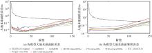
Fig. 5
Geoid degree/cumulative variances of different static gravity field models with referring to EIGEN-6C4"

Tab. 6
The cumulative geoid variances of different static gravity field models at different degree"
| 重力场模型 | 60阶次 | 96阶次 | 120阶次 | 150阶次 |
|---|---|---|---|---|
| GGM02S | 0.55 | 1.90 | 8.31 | 56.09 |
| GGM05S | 0.12 | 0.42 | 1.38 | 7.71 |
| HUST-Grace2016s | 0.07 | 0.30 | 1.25 | 6.80 |
| ITG-Grace02s | 0.17 | 0.52 | 1.96 | 9.20 |
| ITSG-Grace2018s | 0.11 | 0.19 | 0.60 | 1.19 |
| ITU_GRACE16 | 0.15 | 0.99 | 8.54 | 32.35 |
| Tongji-Grace02s | 0.07 | 0.19 | 0.71 | 2.72 |
| IEU-CGS-Static2024 | 0.15 | 0.58 | 2.00 | 11.37 |
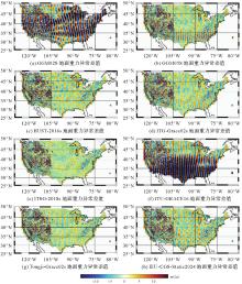
Fig. 6
Differences between static gravity field models and terrestrial gravity anomalies from NGS99 dataset"

Tab. 7
The root mean square of gridding mean of terrestrial gravity anomaly differences of different static gravity field models"
| 重力场模型 | 西部山区 | 东部平原 | 总体 |
|---|---|---|---|
| GGM02S | 6.06 | 7.13 | 6.76 |
| GGM05S | 2.38 | 1.91 | 2.10 |
| HUST-Grace2016s | 2.17 | 1.60 | 1.83 |
| ITG-Grace02s | 2.45 | 1.70 | 2.01 |
| ITSG-Grace2018s | 2.02 | 1.12 | 1.51 |
| ITU_GRACE16 | 10.03 | 11.41 | 10.92 |
| Tongji-Grace02s | 2.08 | 1.34 | 1.65 |
| IEU-CGS-Static2024 | 2.20 | 1.94 | 2.04 |

Fig. 7
Differences between static gravity field models and DTU17 marine gravity anomalies"

Tab. 8
The root mean square of differences between static gravity field models and marine gravity anomaly models"
| 重力场模型 | 海洋重力异常模型的差值RMS | ||
|---|---|---|---|
| SIO_V32.1 | DTU17 | SDUST2023 GRA_MSS | |
| GGM02S | 10.57 | 10.57 | 10.56 |
| GGM05S | 1.56 | 1.58 | 1.48 |
| HUST-Grace2016s | 1.44 | 1.46 | 1.35 |
| ITG-Grace02s | 1.90 | 1.93 | 1.84 |
| ITSG-Grace2018s | 0.80 | 0.85 | 0.64 |
| ITU_GRACE16 | 5.23 | 5.24 | 5.21 |
| Tongji-Grace02s | 0.90 | 0.95 | 0.76 |
| IEU-CGS-Static2024 | 2.29 | 2.30 | 2.23 |
| [1] | 许厚泽, 陆洋, 钟敏, 等. 卫星重力测量及其在地球物理环境变化监测中的应用[J]. 中国科学:地球科学, 2012, 42(6): 843-853. |
| XU Houze, LU Yang, ZHONG Min, et al. Satellite gravimetry and its application in monitoring the change of geophysical environment[J]. Scientia Sinica (Terrae), 2012, 42(6): 843-853. | |
| [2] | 宁津生, 王正涛, 超能芳. 国际新一代卫星重力探测计划研究现状与进展[J]. 武汉大学学报(信息科学版), 2016, 41(1): 1-8. |
| NING Jinsheng, WANG Zhengtao, CHAO Nengfang. Research status and progress in international next-generation satellite gravity measurement missions[J]. Geomatics and Information Science of Wuhan University, 2016, 41(1): 1-8. | |
| [3] | 宁津生. 卫星重力探测技术与地球重力场研究[J]. 大地测量与地球动力学, 2002, 22(1): 1-5. |
| NING Jinsheng. The satellite gravity surveying technology and research of Earth's gravity field[J]. Crustal Deformation and Earthquake, 2002, 22(1): 1-5. | |
| [4] | 宁津生. 跟踪世界发展动态 致力地球重力场研究[J]. 武汉大学学报(信息科学版), 2001, 26(6): 471-474, 486. |
| NING Jinsheng. Following the developments of the world, devoting to the study on the Earth gravity field[J]. Editoral Board of Geomatics and Information Science of Wuhan University, 2001, 26(6): 471-474, 486. | |
| [5] | 郑伟, 许厚泽, 钟敏, 等. 地球重力场模型研究进展和现状[J]. 大地测量与地球动力学, 2010, 30(4): 83-91. |
| ZHENG Wei, XU Houze, ZHONG Min, et al. Progress and present status of research on Earth's gravitational field models[J]. Journal of Geodesy and Geodynamics, 2010, 30(4): 83-91. | |
| [6] | 冯进凯, 王庆宾, 黄佳喜, 等. 多个超高阶重力场模型精度分析[J]. 测绘科学技术学报, 2017, 34(4): 358-363. |
| FENG Jinkai, WANG Qingbin, HUANG Jiaxi, et al. The accuracy analysis of multiple ultra-high-degree gravity field models[J]. Journal of Geomatics Science and Technology, 2017, 34(4): 358-363. | |
| [7] | 罗志才, 钟波, 周浩, 等. 利用卫星重力测量确定地球重力场模型的进展[J]. 武汉大学学报(信息科学版), 2022, 47(10): 1713-1727. |
| LUO Zhicai, ZHONG Bo, ZHOU Hao, et al. Progress in determining the Earth's gravity field model by satellite gravimetry[J]. Geomatics and Information Science of Wuhan University, 2022, 47(10): 1713-1727. | |
| [8] | ZHOU Hao, LUO Zhicai, ZHOU Zebing, et al. HUST-Grace2016s: a new GRACE static gravity field model derived from a modified dynamic approach over a 13-year observation period[J]. Advances in Space Research, 2017, 60(3): 597-611. |
| [9] | CHEN Qiujie, SHEN Yunzhong, FRANCIS O, et al. Tongji-Grace02s and Tongji-Grace02k: high-precision static GRACE-only global earth's gravity field models derived by refined data processing strategies[J]. Journal of Geophysical Research: Solid Earth, 2018, 123(7): 6111-6137. |
| [10] | KVAS A, BROCKMANN J M, KRAUSS S, et al. GOCO06s-a satellite-only global gravity field model[J]. Earth System Science Data, 2021, 13(1): 99-118. |
| [11] | SHAKO R, FÖRSTE C, ABRIKOSOV O, et al. EIGEN-6C: a high-resolution global gravity combination model including GOCE data[M]//Observation of the System Earth from Space-CHAMP, GRACE, GOCE and future missions. Berlin: Springer Berlin Heidelberg, 2013: 155-161. |
| [12] | ZINGERLE P, PAIL R, GRUBER T, et al. The combined global gravity field model XGM2019e[J]. Journal of Geodesy, 2020, 94(7): 66. |
| [13] | 肖云, 杨元喜, 潘宗鹏, 等. 中国卫星跟踪卫星重力测量系统性能与应用[J]. 科学通报, 2023, 68(20): 2655-2664. |
| XIAO Yun, YANG Yuanxi, PAN Zongpeng, et al. Performance and application of the Chinese satellite-to-satellite tracking gravimetry system[J]. Chinese Science Bulletin, 2023, 68(20): 2655-2664. | |
| [14] | XIAO Yun, YANG Yuanxi, PAN Zongpeng, et al. Chinese gravimetry augment and mass change exploring mission status and future[J]. Journal of Geodesy and Geoinformation Science, 2023, 6(3). |
| [15] | 杨元喜, 王建荣, 楼良盛, 等. 航天测绘发展现状与展望[J]. 中国空间科学技术, 2022, 42(3): 1-9. |
| YANG Yuanxi, WANG Jianrong, LOU Liangsheng, et al. Development status and prospect of satellite-based surveying[J]. Chinese Space Science and Technology, 2022, 42(3): 1-9. | |
| [16] | ZHOU Hao, LUO Zhicai, ZHOU Zebing, et al. Impact of different kinematic empirical parameters processing strategies on temporal gravity field model determination[J]. Journal of Geophysical Research: Solid Earth, 2018, 123(11): 10, 252-10, 276. |
| [17] | 游为. 应用低轨卫星数据反演地球重力场模型的理论和方法[D]. 成都: 西南交通大学, 2011. |
| YOU Wei. Theory and methodology of Earth's gravitational field model recovery by Leo data[D]. Chengdu: Southwest Jiaotong University, 2011. | |
| [18] | DARBEHESHTI N, LASSER M, MEYER U, et al. AIUB-GRACE gravity field solutions for G3P: processing strategies and instrument parameterization[J]. Earth System Science Data, 2024, 16(3): 1589-1599. |
| [19] | WÖSKE F, KATO T, RIEVERS B, et al. GRACE accelerometer calibration by high precision non-gravitational force modeling[J]. Advances in Space Research, 2019, 63(3): 1318-1335. |
| [20] | ZHANG Jiahui, YOU Wei, YU Biao, et al. GRACE-FO accelerometer performance analysis and calibration[J]. GPS Solutions, 2023, 27(4): 158. |
| [21] | BEUTLER G, JÄGGI A, MERVART L, et al. The celestial mechanics approach: theoretical foundations[J]. Journal of Geodesy, 2010, 84(10): 605-624. |
| [22] | BEUTLER G, JÄGGI A, MERVART L, et al. The celestial mechanics approach: application to data of the GRACE mission[J]. Journal of Geodesy, 2010, 84(11): 661-681. |
| [23] | MEYER U, JÄGGI A, JEAN Y, et al. AIUB-RL02: an improved time-series of monthly gravity fields from GRACE data[J]. Geophysical Journal International, 2016, 205(2): 1196-1207. |
| [24] | NIE Yufeng, SHEN Yunzhong, PAIL R, et al. Revisiting force model error modeling in GRACE gravity field recovery[J]. Surveys in Geophysics, 2022, 43(4): 1169-1199. |
| [25] | ZHONG Bo, LI Qiong, CHEN Jianli, et al. Improved estimation of regional surface mass variations from GRACE intersatellite geopotential differences using a priori constraints[J]. Remote Sensing, 2020, 12(16): 2553. |
| [26] | LUTHCKE S B, ROWLANDS D D, LEMOINE F G, et al. Monthly spherical harmonic gravity field solutions determined from GRACE inter-satellite range-rate data alone[J]. Geophysical Research Letters, 2006, 33(2): 356-360. |
| [27] | SHEN Zhanglin, CHEN Qiujie, SHEN Yunzhong. An improved acceleration approach by utilizing K-band range rate observations[J]. Remote Sensing, 2023, 15(21): 5260. |
| [28] | YANG Y, CHENG M K, SHUM C K, et al. Robust estimation of systematic errors of satellite laser range[J]. Journal of Geodesy, 1999, 73(7): 345-349. |
| [29] | 王培杰, 陈小斌, 韩鹏, 等. 基于稳健估计、数据筛选和Rhoplus约束的大地电磁数据处理方法[J]. 地球物理学报, 2024, 67(11): 4325-4342. |
| WANG Peijie, CHEN Xiaobin, HAN Peng, et al. Strong interference magnetotelluric data processing method based on robust estimation, data screening and Rhoplus constraint[J]. Chinese Journal of Geophysics, 2024, 67(11): 4325-4342. | |
| [30] |
孙悦, 薛树强, 韩保民, 等. 邻近海底基准站坐标时序联合处理模型[J]. 测绘学报, 2023, 52(11): 1835-1843. DOI: .
doi: 10.11947/j.AGCS.2023.20220203 |
|
SUN Yue, XUE Shuqiang, HAN Baomin, et al. Multi-station joint processing model for seafloor geodetic coordinate time series[J]. Acta Geodaetica et Cartographica Sinica, 2023, 52(11): 1835-1843. DOI: .
doi: 10.11947/j.AGCS.2023.20220203 |
|
| [31] | LYARD F H, ALLAIN D J, CANCET M, et al. FES2014 global ocean tide atlas: design and performance[J]. Ocean Science, 2021, 17(3): 615-649. |
| [32] |
PETIT G, LUZUM B. IERS conventions (2010)[J]. IERS Technical Note, 2010, 36. DOI: .
doi: http://dx.doi.org/ |
| [33] | FOLKNER W, WILLIAMS J, BOGGS D, et al. The planetary and lunar ephemerides DE430 and DE431[R]. [S.l.]: Interplanetary network progress report, 2014, 196(1): 42-196. |
| [34] | DESAI S D. Observing the pole tide with satellite altimetry[J]. Journal of Geophysical Research: Oceans, 2002, 107(C11): 7-1-7-13. |
| [35] | DOBSLAW H, BERGMANN-WOLF I, DILL R, et al. A new high-resolution model of non-tidal atmosphere and ocean mass variability for de-aliasing of satellite gravity observations: AOD1B RL06Free[J]. Geophysical Journal International, 2017, 211(1): 263-269. |
| [36] | HIRT C, GRUBER T, FEATHERSTONE W E. Evaluation of the first GOCE static gravity field models using terrestrial gravity, vertical deflections and EGM2008 quasigeoid heights[J]. Journal of Geodesy, 2011, 85(10): 723-740. |
| [37] | HIRT C, YANG Meng, KUHN M, et al. SRTM2gravity: an ultrahigh resolution global model of gravimetric terrain corrections[J]. Geophysical Research Letters, 2019, 46(9): 4618-4627. |
| [38] | KVAS A, BEHZADPOUR S, ELLMER M, et al. ITSG-Grace2018: overview and evaluation of a new GRACE-only gravity field time series[J]. Journal of Geophysical Research: Solid Earth, 2019, 124(8): 9332-9344. |
| [39] | AKYILMAZ O, USTUN A, AYDIN C, et al. ITU_GRACE16: the global gravity field model including GRACE data up to degree and order 180 of ITU and other collaborating institutions[EB/OL]. [2025-01-25]. DOI: http://doi.org/10.5880/icgem.2016.006. |
| [40] | MAYER-GURR T, EICKER A, ILK K H. ITG-Grace02s: a GRACE gravity field derived from range measurements of short arcs[C]//Proceedings of the 1st International Symposium of the International Gravity Field Service. Ankara: Command of Mapp, 2007. |
| [41] |
RIES J, BETTADPUR R, EANES Z, et al. The development and evaluation of the global gravity Model GGM05[R]. Texas: Center for Space Research, 2016. DOI: .
doi: http://dx.doi.org/10.26153/tsw/1461 |
| [42] | TAPLEY B, RIES J, BETTADPUR S, et al. GGM02-an improved Earth gravity field model from GRACE[J]. Journal of Geodesy, 2005, 79(8): 467-478. |
| [43] | KVAS A, BROCKMANN J M, KRAUSS S, et al. GOCO06s—a satellite-only global gravity field model[J]. Earth System Science Data, 2021, 13(1): 99-118. |
| [44] | ANDERSEN O B, KNUDSEN P. The DTU17 global marine gravity field: first validation results[M]//Fiducial Reference Measurements for Altimetry. Cham: Springer International Publishing, 2019: 83-87. |
| [45] | GUO Jinyun, WEI Xuyang, LI Zhen, et al. SDUST2023GRA_MSS: the new global marine gravity anomaly model determined from mean sea surface model[J]. Scientific Data, 2025, 12(1): 108. |
| [1] | Jiancheng LI, Yunlong WU, Yibing YAO, Zhicai LUO. Satellite gravity technology oriented towards data-scenario-model driven approach: developments, challenges and outlook [J]. Acta Geodaetica et Cartographica Sinica, 2025, 54(9): 1537-1560. |
| [2] | Chaolong YAO, Hongrui YOU, Xuanhui HE, Junya LU, Yiqian XIE, Qiong LI, Shuang ZHU, Zhicai LUO. A composite drought index derived from a combination of GNSS PWV/vertical deformation and GRACE/GRACE-FO data [J]. Acta Geodaetica et Cartographica Sinica, 2025, 54(10): 1757-1768. |
| [3] | ZOU Xiancai. Calibration of the Satellite Gravity Gradients for GOCE and Analysis on Its Drag Free Control System [J]. Acta Geodaetica et Cartographica Sinica, 2018, 47(3): 291-297. |
| [4] | SHEN Yunzhong. Algorithm Characteristics of Dynamic Approach-based Satellite Gravimetry and Its Improvement Proposals [J]. Acta Geodaetica et Cartographica Sinica, 2017, 46(10): 1308-1315. |
| [5] | CHEN Qiujie, SHEN Yunzhong, ZHANG Xingfu, CHEN Wu, XU Houze. GRACE Data-based High Accuracy Global Static Earth's Gravity Field Model [J]. Acta Geodaetica et Cartographica Sinica, 2016, 45(4): 396-403. |
| Viewed | ||||||
|
Full text |
|
|||||
|
Abstract |
|
|||||