

Acta Geodaetica et Cartographica Sinica ›› 2025, Vol. 54 ›› Issue (10): 1786-1797.doi: 10.11947/j.AGCS.2025.20250124
• Geodesy and Navigation • Previous Articles Next Articles
Hailu CHEN( ), Yunzhong SHEN()
Received:2025-03-28
Revised:2025-07-09
Online:2025-11-14
Published:2025-11-14
Contact:
Yunzhong SHEN
E-mail:2210929@tongji.edu.cn;yzshen@tongji.edu.cn
About author:CHEN Hailu (1996—), male, PhD candidate, majors in InSAR data processing. E-mail: 2210929@tongji.edu.cn
Supported by:CLC Number:
Hailu CHEN, Yunzhong SHEN. GNSS-assisted InSAR tropospheric delay correction model incorporating vertical stratification and turbulent components[J]. Acta Geodaetica et Cartographica Sinica, 2025, 54(10): 1786-1797.
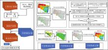
Fig. 1
The flowchart of the proposed method and calculation of interferogram correction"


Fig. 2
The study area and data coverage"

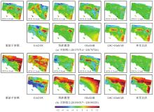
Fig. 3
Two unwrapped interferograms before and after tropospheric delays correction"


Fig. 4
Comparison of standard deviation of 70 short temporal baseline interferograms before and after the troposphere corrections"
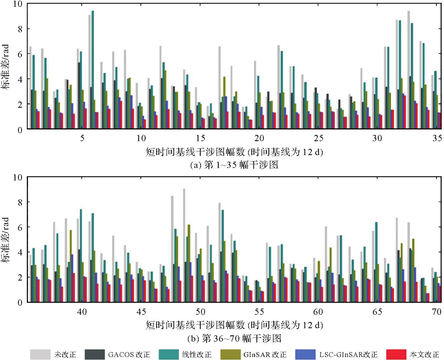

Fig. 5
Linear deformation rates before and after correction (circles represent GNSS observation)"
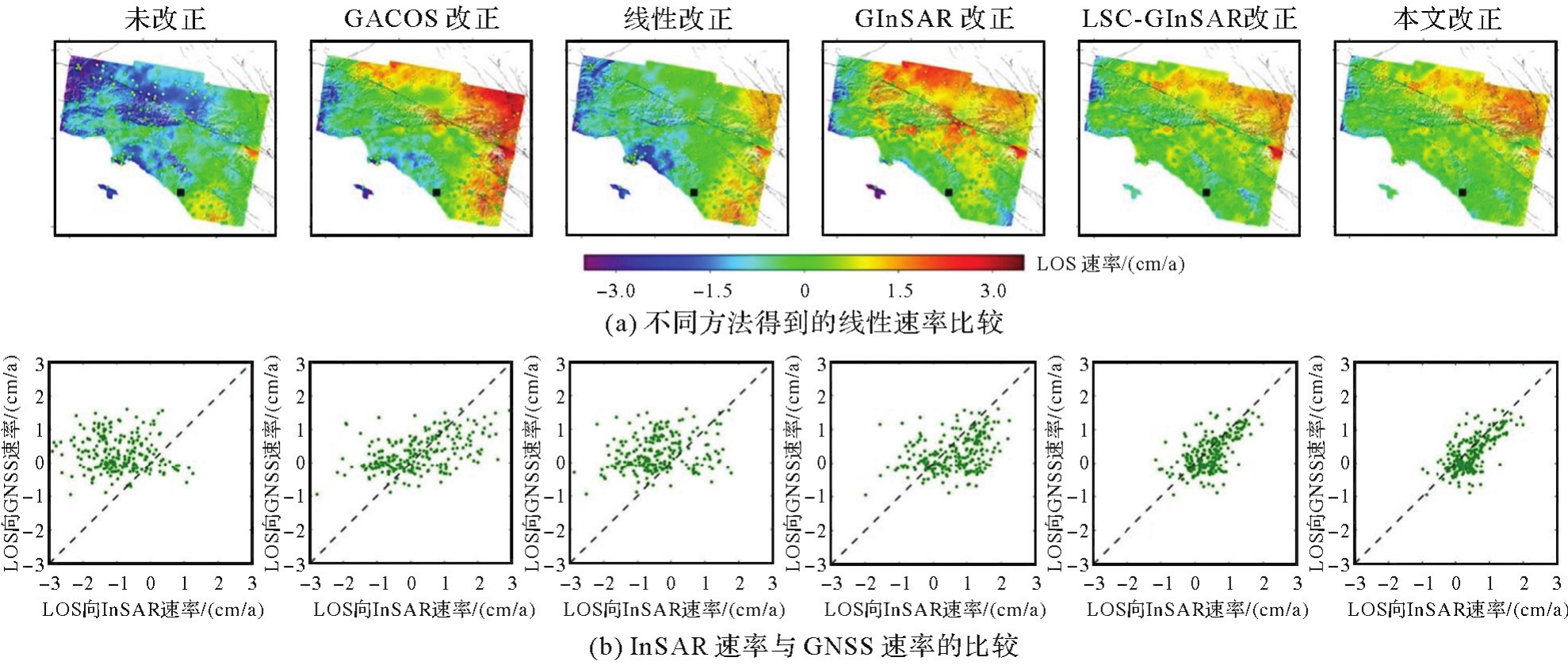

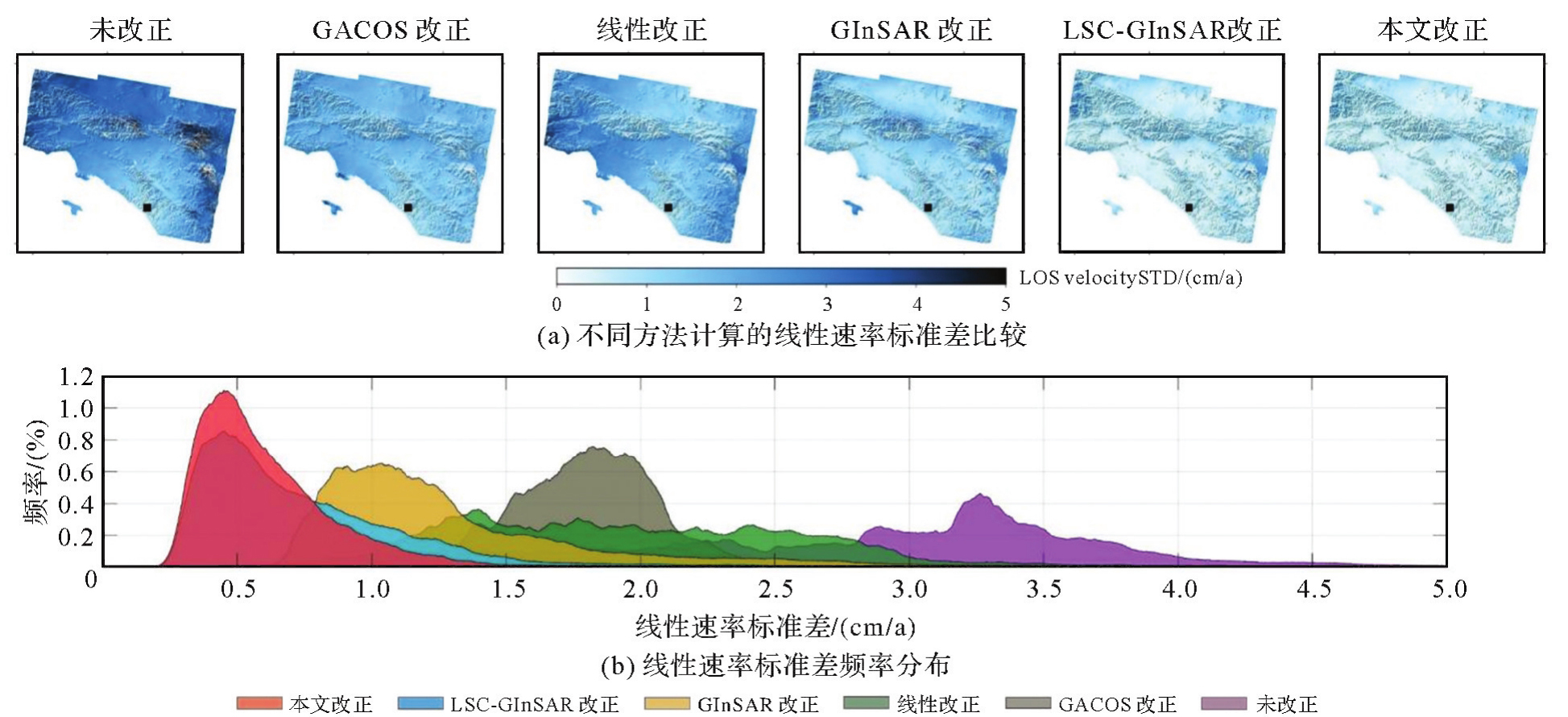
Fig. 6
Standard deviation of linear deformation rates before and after correction"
Tab. 1
GNSS station classification in terms of elevation"
| 高度/m | 类型 |
|---|---|
| [0,200) | 低海拔 |
| [200,800) | 中海拔 |
| [800,∞) | 高海拔 |
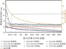
Fig. 7
Performance of correction with various calculated GNSS stations"

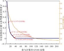
Fig. 8
Difference between estimated stratified parameters and references with various calculated GNSS stations"
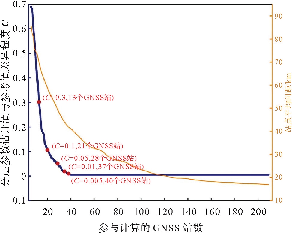
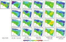
Fig. 9
Tropospheric delay estimation using various GNSS"


Fig. 10
The differences between measured and calculated values at checking GNSS stations in Fig.9"
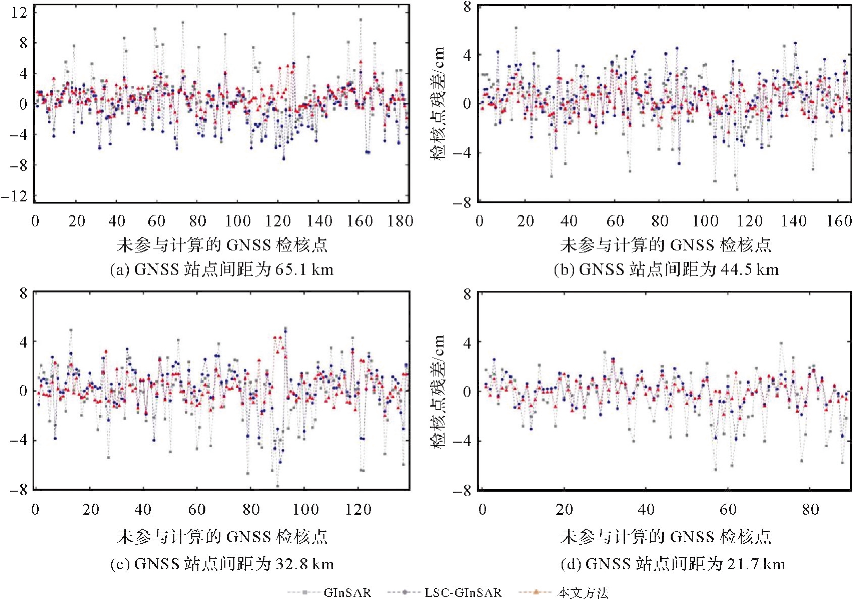
Tab. 2
RMSE of GNSS checking stations residuals in Fig.9"
| GNSS站点间距/km | GInSAR/cm | LSC-GInSAR/cm | 本文方法/cm |
|---|---|---|---|
| 65.1 | 3.4 | 2.5 | 1.7 |
| 44.5 | 2.3 | 1.9 | 1.3 |
| 32.8 | 2.5 | 1.8 | 1.1 |
| 21.7 | 2.3 | 1.3 | 0.7 |
| [1] | 李振洪, 宋闯, 余琛, 等. 卫星雷达遥感在滑坡灾害探测和监测中的应用:挑战与对策[J]. 武汉大学学报(信息科学版), 2019, 44(7): 967-979. |
| LI Zhenhong, SONG Chuang, YU Chen, et al. Application of satellite radar remote sensing to landslide detection and monitoring: challenges and solutions[J]. Geomatics and Information Science of Wuhan University, 2019, 44(7): 967-979. | |
| [2] | LI Zhenhong, YU Chen, XIAO Ruya, et al. Entering a new era of InSAR: advanced techniques and emerging applications[J]. Journal of Geodesy and Geoinformation Science, 2022, 5(1): 168-172. |
| [3] |
刘计洪, 胡俊, 李志伟, 等. InSAR三维同震地表形变监测:窗口优化的SM-VCE算法[J]. 测绘学报, 2021, 50(9): 1222-1239. DOI: .
doi: 10.11947/j.AGCS.2021.20200610 |
|
LIU Jihong, HU Jun, LI Zhiwei, et al. Estimation of 3D coseismic deformation with InSAR: an improved SM-VCE method by window optimization[J]. Acta Geodaetica et Cartographica Sinica, 2021, 50(9): 1222-1239. DOI: .
doi: 10.11947/j.AGCS.2021.20200610 |
|
| [4] |
朱建军, 杨泽发, 李志伟. InSAR矿区地表三维形变监测与预计研究进展[J]. 测绘学报, 2019, 48(2): 135-144. DOI: .
doi: 10.11947/j.AGCS.2019.20180188 |
|
ZHU Jianjun, YANG Zefa, LI Zhiwei. Recent progress in retrieving and predicting mining-induced 3D displace-ments using InSAR[J]. Acta Geodaetica et Cartographica Sinica, 2019, 48(2): 135-144. DOI: .
doi: 10.11947/j.AGCS.2019.20180188 |
|
| [5] | ZHANG Lei, LU Zhong, DING Xiaoli, et al. Mapping ground surface deformation using temporarily coherent point SAR interferometry: application to Los Angeles basin[J]. Remote Sensing of Environment, 2012, 117: 429-439. |
| [6] | ZHAO Chaoying, LU Zhong, ZHANG Qin, et al. Large-area landslide detection and monitoring with ALOS/PALSAR imagery data over Northern California and Southern Oregon, USA[J]. Remote Sensing of Environment, 2012, 124: 348-359. |
| [7] | LI Zhiwei, CAO Yunmeng, WEI Jianchao, et al. Time-series InSAR ground deformation monitoring: atmospheric delay modeling and estimating[J]. Earth-Science Reviews, 2019, 192: 258-284. |
| [8] | DOIN M P, LASSERRE C, PELTZER G, et al. Corrections of stratified tropospheric delays in SAR interferometry: validation with global atmospheric models[J]. Journal of Applied Geophysics, 2009, 69(1): 35-50. |
| [9] | JOLIVET R, AGRAM P S, LIN N Y, et al. Improving InSAR geodesy using global atmospheric models[J]. Journal of Geophysical Research: Solid Earth, 2014, 119(3): 2324-2341. |
| [10] | YU Chen, LI Zhenhong, PENNA N T, et al. Generic atmospheric correction model for interferometric synthetic aperture radar observations[J]. Journal of Geophysical Research: Solid Earth, 2018, 123(10): 9202-9222. |
| [11] | HANSSEN R F. Radar Interferometry: data interpretation and error analysis[M]. London: Springer Science & Business Media, 2001. |
| [12] | CHEN Hailu, SHEN Yunzhong. LSC-GInSAR: a GNSS-enhanced InSAR approach by using least squares collocation open access[J]. Geophysical Journal International, 2023, 236(1): 49-61. |
| [13] | ZHANG Xuesong, LI Zhenhong, LIU Zhenjiang. Reduction of atmospheric effects on InSAR observations through incorporation of GACOS and PCA into small baseline subset InSAR[J]. IEEE Transactions on Geoscience and Remote Sensing, 2023, 61: 5209115. |
| [14] | LOHMAN R B, SIMONS M. Some thoughts on the use of InSAR data to constrain models of surface deformation: noise structure and data downsampling[J]. Geochemistry, Geophysics, Geosystems, 2005, 6: Q01007. |
| [15] | BEKAERT D P S, HOOPER A, WRIGHT T J. A spatially variable power law tropospheric correction technique for InSAR data[J]. Journal of Geophysical Research: Solid Earth, 2015, 120(2): 1345-1356. |
| [16] | LIANG Hongyu, ZHANG Lei, DING Xiaoli, et al. Toward mitigating stratified tropospheric delays in multitemporal InSAR: a quadtree aided joint model[J]. IEEE Transactions on Geoscience and Remote Sensing, 2019, 57(1): 291-303. |
| [17] | HOOPER A. A multi-temporal InSAR method incorporating both persistent scatterer and small baseline approaches[J]. Geophysical Research Letters, 2008, 35: L16302. |
| [18] | LIANG Hongyu, ZHANG Lei, LU Zhong, et al. Correction of spatially varying stratified atmospheric delays in multitemporal InSAR[J]. Remote Sensing of Environment, 2023, 285: 113382. |
| [19] | WANG Shuai, LU Zhong, WANG Bin, et al. A phase-based InSAR tropospheric correction method for interseismic deformation based on short-period interferograms[J]. IEEE Transactions on Geoscience and Remote Sensing, 2023, 61: 5212318. |
| [20] | LIU Jihong, HU Jun, BÜRGMANN R, et al. Mitigating atmospheric delays in InSAR time series: the DetrendInSAR method and its validation[J]. Journal of Geophysical Research: Solid Earth, 2024, 129(5): e2024JB028920. |
| [21] | CHEN Hailu, SHEN Yunzhong, ZHANG Lei, et al. Mitigation of tropospheric turbulent delays in InSAR time series by incorporating a stochastic process[J]. ISPRS Journal of Photogrammetry and Remote Sensing, 2025, 222: 186-203. |
| [22] | LI Z W, XU W B, FENG G C, et al. Correcting atmospheric effects on InSAR with MERIS water vapour data and elevation-dependent interpolation model[J]. Geophysical Journal International, 2012, 189(2): 898-910. |
| [23] | LI Zhenhong, MULLER J P, CROSS P, et al. Interferometric synthetic aperture radar (InSAR) atmospheric correction: GPS, moderate resolution imaging spectroradiometer (MODIS), and InSAR integration[J]. Journal of Geophysical Research: Solid Earth, 2005, 110(B3): B03410. |
| [24] | CAO Yunmeng, JÓNSSON S, LI Zhiwei. Advanced InSAR tropospheric corrections from global atmospheric models that incorporate spatial stochastic properties of the troposphere[J]. Journal of Geophysical Research: Solid Earth, 2021, 126(5): e2020JB020952. |
| [25] | YU Chen, PENNA N T, LI Zhenhong. Generation of real-time mode high-resolution water vapor fields from GPS observations[J]. Journal of Geophysical Research: Atmospheres, 2017, 122(3): 2008-2025. |
| [26] | NEELY W R, BORSA A A, SILVERII F. GInSAR: a cGPS correction for enhanced InSAR time series[J]. IEEE Transactions on Geoscience and Remote Sensing, 2020, 58(1): 136-146. |
| [27] | LIU Yuhao, WANG Guoquan, YU Xiao, et al. Sentinel-1 InSAR and GPS-integrated long-term and seasonal subsidence monitoring in Houston, Texas, USA[J]. Remote Sensing, 2022, 14(23): 6184. |
| [28] | GUNS K, XU Xiaohua, BOCK Y, et al. GNSS-corrected InSAR displacement time-series spanning the 2019 Ridgecrest, CA earthquakes[J]. Geophysical Journal International, 2022, 230(2): 1358-1373. |
| [29] | LIU Ning, DAI Wujiao, SANTERRE R, et al. High spatio-temporal resolution deformation time series with the fusion of InSAR and GNSS data using spatio-temporal random effect model[J]. IEEE Transactions on Geoscience and Remote Sensing, 2019, 57(1): 364-380. |
| [30] | GE L, HAN S, RIZOS C. The double interpolation and double prediction (DIDP) approach for InSAR and GPS integration[J]. International Archives of Photogrammetry and Remote Sensing, 2000, 33(B2): 205-212. |
| [31] | 占文俊, 李志伟, 韦建超, 等. 一种InSAR大气相位建模与估计方法[J]. 地球物理学报, 2015, 58(7): 2320-2329. |
| ZHAN Wenjun, LI Zhiwei, WEI Jianchao, et al. A strategy for modeling and estimating atmospheric phase of SAR interferogram[J]. Chinese Journal of Geophysics, 2015, 58(7): 2320-2329. | |
| [32] | KRAUP T A. Contribution to the mathematical foundation of physical geodesy[M]//mathematical foundation of geodesy. Berlin: Springer, 2006: 29-90. |
| [33] | YANG Y, ZENG A, ZHANG J. Adaptive collocation with application in height system transformation[J]. Journal of Geodesy, 2009, 83(5): 403-410. |
| [34] | ROSEN P A, GURROLA E M, SACCO G F, et al. The InSAR scientific computing environment[C]//Proceedings of 2012 European Conference on Synthetic Aperture Radar. Hangzhou: IEEE, 2012. |
| [35] | GOLDSTEIN R M, WERNER C L. Radar interferogram filtering for geophysical applications[J]. Geophysical Research Letters, 1998, 25(21): 4035-4038. |
| [36] | CHEN C W, ZEBKER H A. Two-dimensional phase unwrapping with use of statistical models for cost functions in nonlinear optimization[J]. Journal of the Optical Society of America, 2001, 18(2): 338. |
| [37] | FATTAHI H, AMELUNG F. DEM error correction in InSAR time series[J]. IEEE Transactions on Geoscience and Remote Sensing, 2013, 51(7): 4249-4259. |
| [38] |
宋鑫友, 张磊, 李涛, 等. 陆探一号干涉SAR在轨测试阶段基线精化与DEM精度分析[J]. 测绘学报, 2024, 53(10): 1920-1929. DOI: .
doi: 10.11947/j.AGCS.2024.20230540 |
|
SONG Xinyou, ZHANG Lei, LI Tao, et al. Baseline refinement and DEM accuracy analysis during the in-orbit test phase of LT-1SAR[J]. Acta Geodaetica et Cartographica Sinica, 2024, 53(10): 1920-1929. DOI: .
doi: 10.11947/j.AGCS.2024.20230540 |
|
| [39] | ZHANG Yunjun, FATTAHI H, AMELUNG F. Small baseline InSAR time series analysis: unwrapping error correction and noise reduction[J]. Computers & Geosciences, 2019, 133: 104331. |
| [40] | MILBERT D. Solid: solid earth tide[EB/OL]. [2024-10-15]. http://geodesyworld.github.io/SOFTS/solid.html. |
| [41] | DABBERDT W F, SHELLHORN R A. On the optimal spatial sampling of atmospheric data[J]. Journal of Applied Meteorology, 1973, 12(1), 34-44. |
| [1] | Zhong LU, Jinqi ZHAO, Yufen NIU, Liquan CHEN, Qianyou FAN, Jinzhao SI, Zixuan WANG, Yuan GAO, Shuai WANG, Feifei QU, Hongtao SHI, Shiyong YAN, Yun SHI, Zheng ZHAO. The NISAR mission: innovations in earth observation and applications in surface deformation monitoring [J]. Acta Geodaetica et Cartographica Sinica, 2026, 55(2): 261-274. |
| [2] | Peng LI, Jianbo BAI, Zhenhong LI, Houjie WANG. Wide area coastal subsidence monitoring and driver analysis with multi tracks of TS-InSAR—a case study of Shandong province [J]. Acta Geodaetica et Cartographica Sinica, 2025, 54(7): 1178-1191. |
| [3] | Kefu WU, Haiqiang FU, Jianjun ZHU, Qijin HAN, Aichun WANG, Mingxia ZHANG, Zhiwei LI. LT-1 InSAR block adjustment considering the impact of penetration depth in forest areas [J]. Acta Geodaetica et Cartographica Sinica, 2025, 54(6): 1009-1020. |
| [4] | Zhaofeng DU, Guopeng LI, Zhanke LIU, Xiaming SHANG, Shengjun KANG, Xiaoqiang WANG. Comprehensive analysis of multiple monitoring methods in main subsidence areas [J]. Acta Geodaetica et Cartographica Sinica, 2025, 54(3): 481-492. |
| [5] | Shuren GUO, Hongliang CAI, Weiguang GAO, Wei ZHOU, Changjiang GENG, Gang LI, Ming DONG, Chengeng SU, Kun JIANG, Yinan MENG, Lei CHEN, Junyang PAN, Kai LI, Qifen LI, Xiaomei TANG, Shuangna ZHANG, Xiaogong HU. A novel architecture of global navigation satellite system for accurate and trusted PNT services [J]. Acta Geodaetica et Cartographica Sinica, 2025, 54(11): 1934-1953. |
| [6] | Jinwei BU, Kegen YU, Qiulan WANG, Linghui LI, Xinyu LIU, Xiaoqing ZUO, Jun CHANG. Deep learning retrieval method for global ocean significant wave height by integrating spaceborne GNSS-R data and multivariable parameters [J]. Acta Geodaetica et Cartographica Sinica, 2024, 53(7): 1321-1335. |
| [7] | Liming JIANG, Yi SHAO, Zhiwei ZHOU, Peifeng MA, Teng WANG. A review of intelligent InSAR data processing: recent advancements, challenges and prospects [J]. Acta Geodaetica et Cartographica Sinica, 2024, 53(6): 1037-1056. |
| [8] | Canghai ZHOU, Zhen TIAN, Zhen SHI, Hayinaer TUOKAN. The characteristic of the Yadong-Gulu faults motion constraints by InSAR timeseries and GNSS observations [J]. Acta Geodaetica et Cartographica Sinica, 2024, 53(5): 933-945. |
| [9] | Jun ZHU, Wei PENG, Haiqiang FU, Man OU, Shancheng LEI, Shiping ZHANG. Large-scale TanDEM-X InSAR sub-canopy topography inversion under insufficient observation information [J]. Acta Geodaetica et Cartographica Sinica, 2024, 53(5): 959-966. |
| [10] | Yandong GAO, Yikun JIA, Shijin LI, Yu CHEN, Huaizhan LI, Nanshan ZHENG, Shubi ZHANG. The improved max-flow/min-cut weight algorithm for InSAR phase unwrapping [J]. Acta Geodaetica et Cartographica Sinica, 2024, 53(4): 644-652. |
| [11] | HE Yi, YANG Wang, ZHU Qing. An InSAR phase unwrapping method based on R2AU-Net [J]. Acta Geodaetica et Cartographica Sinica, 2024, 53(3): 435-449. |
| [12] | WANG Yuan, XU Huaping, LI Chunsheng, ZENG Guobing, LIU Aifang, GE Shiqi. Analysis of interferometric mapping accuracy for spaceborne distributed SAR dual-frequency alternative bistatic mode [J]. Acta Geodaetica et Cartographica Sinica, 2024, 53(3): 463-472. |
| [13] | YUE Jiawei, HUANG Qihuan, LIU Hui, MA Zhangfeng. A multi-baseline phase unwrapping method based on a discrete optimization framework [J]. Acta Geodaetica et Cartographica Sinica, 2024, 53(3): 473-481. |
| [14] | Xinyou SONG, Lei ZHANG, Tao LI, Baocheng LEI, Ruiqing SONG. Baseline refinement and DEM accuracy analysis during the in-orbit test phase of LT-1 SAR [J]. Acta Geodaetica et Cartographica Sinica, 2024, 53(10): 1920-1929. |
| [15] | Bing XU, Yan ZHU, Zhiwei LI, Huiwei YI, Miaowen HU, Qi CHEN, Kun HAN, Xun DU. Analysis of InSAR time-series deformation monitoring accuracy of domestic satellite [J]. Acta Geodaetica et Cartographica Sinica, 2024, 53(10): 1930-1941. |
| Viewed | ||||||
|
Full text |
|
|||||
|
Abstract |
|
|||||