

Acta Geodaetica et Cartographica Sinica ›› 2025, Vol. 54 ›› Issue (11): 1934-1953.doi: 10.11947/j.AGCS.2025.20250175
• Geodesy and Navigation • Previous Articles Next Articles
Shuren GUO1,2( ), Hongliang CAI1,2(), Weiguang GAO1,2, Wei ZHOU1,2, Changjiang GENG3,4, Gang LI1,2, Ming DONG1,2, Chengeng SU1,2, Kun JIANG1,2, Yinan MENG1,2, Lei CHEN1,2, Junyang PAN1,2,5, Kai LI5, Qifen LI4, Xiaomei TANG6, Shuangna ZHANG7, Xiaogong HU5
Received:2025-04-21
Revised:2025-10-12
Online:2025-12-15
Published:2025-12-15
Contact:
Hongliang CAI
E-mail:1414263503@qq.com;caibanyu@126.com
About author:GUO Shuren (1972—), male, PhD, researcher, majors in satellite navigation overall technology and spatio-temporal reference technology. E-mail: 1414263503@qq.com
Supported by:CLC Number:
Shuren GUO, Hongliang CAI, Weiguang GAO, Wei ZHOU, Changjiang GENG, Gang LI, Ming DONG, Chengeng SU, Kun JIANG, Yinan MENG, Lei CHEN, Junyang PAN, Kai LI, Qifen LI, Xiaomei TANG, Shuangna ZHANG, Xiaogong HU. A novel architecture of global navigation satellite system for accurate and trusted PNT services[J]. Acta Geodaetica et Cartographica Sinica, 2025, 54(11): 1934-1953.
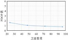
Fig. 1
PDOP values of MEO constellation varied with satellite numbers"
Tab. 1
UERE errors and their limits"
| 误差源 | 误差组项 | 现有能力 | 极限能力预测 |
|---|---|---|---|
| 空间段URE | 轨道 | 0.1 | 0.02 |
| 钟差 | 0.3 | 0.03 | |
| 信号时延 | 0.3 | 0.03 | |
| 环境段UIE | 电离层 | 0.8 | 0.7 |
| 对流层 | 0.1 | 0.1 | |
| 用户端UEE | 多径 | 0~0.5 | 0~0.5 |
| 噪声 | 0.05~0.2 | 0.05 |
Tab. 2
Constellation parameters of four global navigation satellite systems"
| 系统 | 标称星座 | 轨道倾角/(°) | 轨道高度/km | 实际工作卫星数量 | PDOP值 |
|---|---|---|---|---|---|
| BDS-3 | 24颗MEO卫星(Walker24/3/1) | 55 | 21 528 | 24 | 1.43 |
| 3颗GEO、3颗IGSO卫星 | 0/55 | 35 786 | 6 | ||
| GPS | 24颗MEO卫星(6个轨道面) | 55 | 20 200 | 31 | 1.62 |
| GLONASS | 24颗MEO卫星(3个轨道面) | 64.8 | 19 100 | 24 | 1.93 |
| Galileo | 27颗MEO卫星(Walker24/3/1) | 56 | 23 200 | 24 | 1.92 |
Tab. 3
Navigation data rates for the main GNSS signal components"
| 导航系统 | 信号分量 | 电文速率/bps | 符号速率/sps | 调制方式 |
|---|---|---|---|---|
| BDS-3 | B1I(MEO) | 50 | 50 | BPSK |
| B1C数据分量 | 50 | 100 | BOC(1,1) | |
| B1C导频分量 | 0 | 0 | QMBOC | |
| PPP-B2b | 500 | 1000 | BPSK | |
| GPS | L1C/A | 50 | 50 | BPSK |
| L1C数据分量 | 50 | 100 | BOC(1,1) | |
| L1C导频分量 | 0 | 0 | TMBOC | |
| Galileo | E1-B | 125 | 250 | CBOC |
| E1-C | 0 | 0 | CBOC | |
| E6-B | 500 | 1000 | BPSK | |
| E6-C | 0 | 0 | BPSK | |
| GLONASS | G1 | 50 | 50 | BPSK |
| L1OCd | 125 | 250 | BPSK |
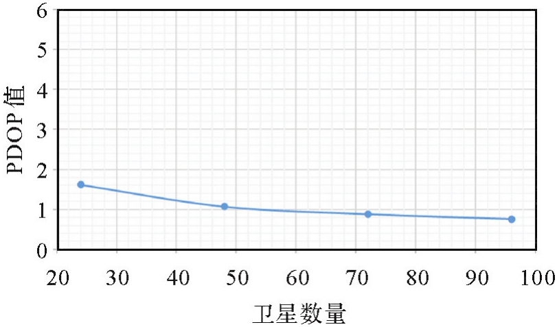
Fig. 2
Relationships between navigation message symbol rate and the capturing/tracking level"
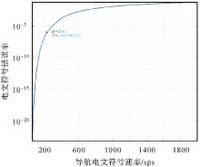
Fig. 3
Relationships between navigation message rate and navigation message BER (level: -170 dBW)"
Tab. 4
Relationships between altitude and type of satellite orbit and ambiguity convergence time"
| 轨道高度与类型 | 模糊度收敛所需时间 | 模糊度100%整数解所需时间 |
|---|---|---|
| 低轨(1000 km) | 1 min | 10 min |
| 中轨(20 000 km) | 20 min | 4 h |
| 高轨IGSO(36 000 km) | 2 h | 25 h |
| 高轨GEO(36 000 km) | +∞ | +∞ |
Tab. 5
Advantages and disadvantages of different frequencies for use as navigation signals"
| 频段 | 频段范围/MHz | 优点 | 缺点 |
|---|---|---|---|
| UHF | 400 | 空间传播损耗小穿透能力强 | 电离层延迟大收发天线尺寸大 |
| L | 1164~1300 | 用户设备实现简单、接收机天线易实现 | 频谱资源相对有限,更为拥挤 |
| 1559~1660 | 小型化、使用便捷 | ||
| S | 2483.5~2500 | 电离层延迟较小,频率协调难度小 | 空间传播损耗大,与移动通信互扰 |
| C | 5010~5030 | 电离层延迟小 | 空间传播损耗大,接收复杂度高,受雨衰遮挡影响大 |
Fig. 4
Frequency bands of existing GNSS signals"
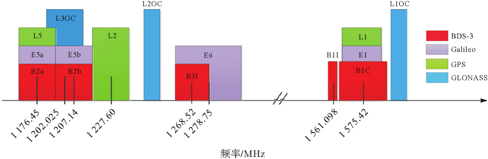
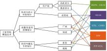
Fig. 5
Satellite navigation augmentation technologies classification"

Tab. 6
Comparison of characteristics of different augmentation systems"
| 增强系统分类 | 典型系统 | 覆盖性 | 地面站数量 | 精度 | 动态性 |
|---|---|---|---|---|---|
| 广域精密定位系统 | Star Fire、OmniStar | 数千千米 | 数十个参考站 | 分米级至厘米级的精密定位服务 | ~20 min |
| 广域PPP-RTK定位系统 | CLAS | 数百到数千千米 | 每50~70千米一个站,约上千个监测站 | 分米级至厘米级的精密定位服务 | ~1 min |
| 局域精密定位系统 | CORS | 数十千米 | 数个参考站 | 支持分米至厘米的实时服务,以及毫米的事后服务 | 秒级 |
| 广域完好性定位系统 | WAAS、EGNOS | 数千千米 | 数十个参考站 | 米级定位精度服务和APV-I的完好性服务 | 实时高动态 |
| 局域完好性定位系统 | GBAS | 数十千米 | 数个参考站 | 米级定位精度服务和CAT-I的完好性服务 | 实时高动态 |
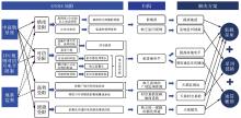
Fig. 6
Causes and solutions for the limitations of existing GNSS architectures"

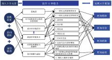
Fig. 7
The novel GNSS architecture design"
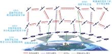
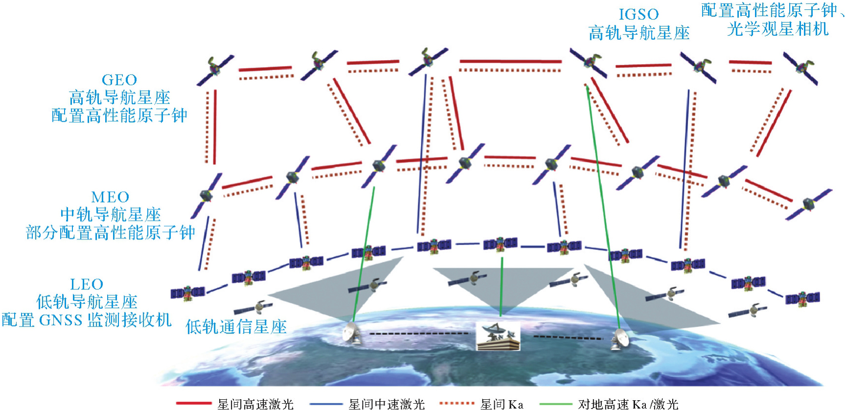
Fig. 8
The novel satellite navigation system architecture"
Tab. 7
New elements of GNSS architecture"
| 新增元素 | 部署位置 | 实现方式 | 与现有设施关系 | 承载业务/功能 | 能力增量 | 用户设备形态 | |
|---|---|---|---|---|---|---|---|
| 通信辅助 | 各类通信设施 | 软件升级 | 相互独立 | GNSS性能增强 | 缩短GNSS设备冷启动时间,承载高精度增强电文,实现双向认证 | 现有导航设备+相关通信设备 | |
| 低轨星座 | LEO导航星座及其地面设施 | 新建/接入 | 相互独立+深度融合 | 全球高精度/完好性 | 全球近实时分米级高精度、抗干扰能力大幅提高、承载更高的信息速率,实现对中高轨星座导航信号的全球范围监测 | 现有导航设备软件升级 | |
| 星间链路 | 高速激光 | GEO/IGSO/MEO | 卫星增配 | 在轨卫星替换 | 星座运管/时空测定/通信中继 | 简化地面设施,降低建设与运行成本 支撑天基空间基准的建立与维持 | 现有导航设备 |
| Ka | GEO/IGSO/MEO,LEO(可选) | 卫星增配 | 在轨卫星替换 | 时空测定/灵活接入 | 现有导航设备 | ||
| 中速激光 | LEO,GEO/IGSO/MEO(可选) | 卫星增配 | 在轨卫星替换 | 星座运管/时空测定/通信中继 | 现有导航设备 | ||
| 配套对地链路Ka/激光 | GEO/IGSO,LEO(可选) | 卫星增配+主控站/注入站增配 | 在轨卫星替换+地面增配 | 星座运管/对地时空溯源/数据落地 | 现有导航设备 | ||
| 高性能测量部件 | 原子钟组 | GEO/IGSO/部分MEO卫星 | 卫星增配 | 在轨卫星替换 | 天基时间基准 | 实现天基综合原子时建立与维持 | 现有导航设备 |
| 恒星相机 | IGSO卫星 | 卫星增配 | 在轨卫星替换 | 天基空间基准 | 实现天基空间基准的建立与维持 | 现有导航设备 | |
Tab. 8
Integrated hybrid architecture with GEO, IGSO, MEO, and LEO constellations"
| 轨道类型 | 数量/颗 | 架构贡献 | 提供服务 |
|---|---|---|---|
| MEO | 24~30 | 核心星座 1. 全球4重以上RNSS信号覆盖 2. 支持地面站与低轨星座时空基准维持 3. 部分卫星参与建立天基时空基准 | 全球米级PNT服务(3000 km以下)、SSV |
| GEO | 3~6(按需) | 节点星座 1. 改善区域可见性(高纬度) 2. 天基时空基准建立 3. 对地数据传输与时空基准固联 4. 加强对区域的RNSS信号覆盖 | 区域多样化服务、SSV、导航覆盖增强 |
| IGSO | 3~6(按需) | ||
| LEO | 150~200 | 增强星座 1. 实时高精度PNT 2. 高功率导航信号,改善PNT服务可用性与可信度 3. 监测GEO、IGSO、MEO星座服务与性能 4. 改善GEO、IGSO、MEO时空确定观测几何 | 全球分米级高精度高可信服务(30 km以下) |
Tab. 9
Increments added to LEO constellations (compared to those of the GEO/IGSO and MEO constellations)"
| 增量 | 增量信息 |
|---|---|
| 定位精度 | 从10 m提高到0.1 m |
| 完好性 | 从区域CAT-1扩展到全球CAT-1 |
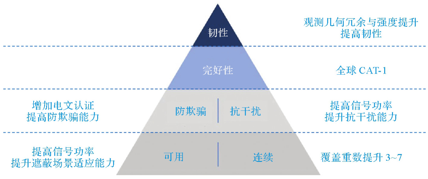
| 信息速率 | 从50 bps提高到1000 bps以上 |
| 防欺骗 | 支持增加电文认证,提高防欺骗能力 |
| 抗干扰 | 信号功率提高30分贝左右 |
| 可用性 | 提升遮蔽场景适应能力 |
| 连续性 | 覆盖重数提升3~7重 |
| 低轨与中高轨星座 | 低轨对中高轨实现全球监测 |
| 相互赋能 | 中高轨为低轨提供时空基准 |
Tab. 10
Main characteristic parameters of the inter-satellite links"
| 类别 | 类型 | 部署卫星 | 速率/精度 | 支持业务类型 |
|---|---|---|---|---|
| 星间链路 | 高速激光 | GEO、IGSO、MEO | Gbps/ps | 星座运管、通信中继、时空测定、外部中继(可选) |
| Ka | GEO、IGSO、MEO、LEO(可选) | Mbps/ps | 星座运管、时空测定、灵活接入 | |
| 中速激光 | LEO GEO、IGSO、MEO(可选) | Mbps/ps | 星座运管、通信中继、时空测定 | |
| 对地链路 | Ka/激光 | GEO、IGSO LEO(可选) | Gbps/ps | 对地数据传输和时空基准固联 |
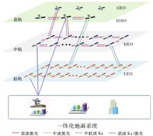
Fig. 9
The inter-satellite link establishment"

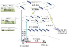
Fig. 10
Space-based architecture of the time reference"
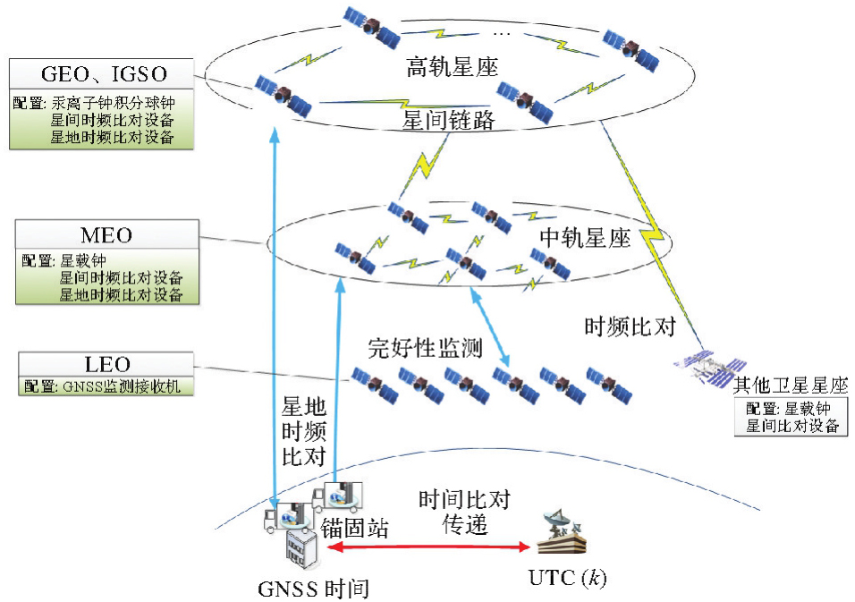
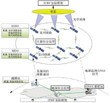
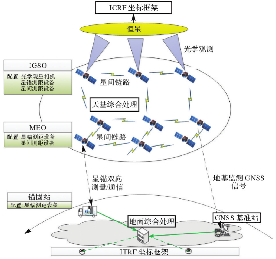
Fig. 11
Space-based architecture of the space reference"
Tab. 11
Main configuration of space-based spatio-temporal reference satellites"
| 类型 | 部署卫星 | 功能作用 |
|---|---|---|
| 汞离子钟/积分球钟星间、星地测量设备 | GEO、IGSO | 建立天基时间基准 |
| 大面阵观星相机星间、星地测量设备 | IGSO | 建立天基空间基准 |
| 配置星间、星地测量设备 | MEO | 支撑构建天基时空基准 |
| 配置导航监测接收机 | LEO | 获取中高轨建立的时空基准 |
| 配置星地测量设备 | 地面锚固站 | 建立天基时空基准与地球时空基准的联系 |
Tab. 12
LEO navigation signal in downlink"
| 信号体制 | 参数信息 |
|---|---|
| 使用频段 | L1、L5(或其他适合的频段) |
| 调制方式 | BPSK |
| 信息速率 | 大于1000 bps |
| 落地电平 | -130 d BW |
| 防欺骗 | 认证信息 |
| 广播星历模型 | 20参数 |
| 兼容性 | 与现有GNSS导航信号(或与合适的通信信号)兼容 |
| 互操作 | 首选与L1、L5互操作 |
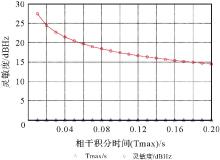
Fig. 12
Acquisition sensitivity at different coherent integration times"
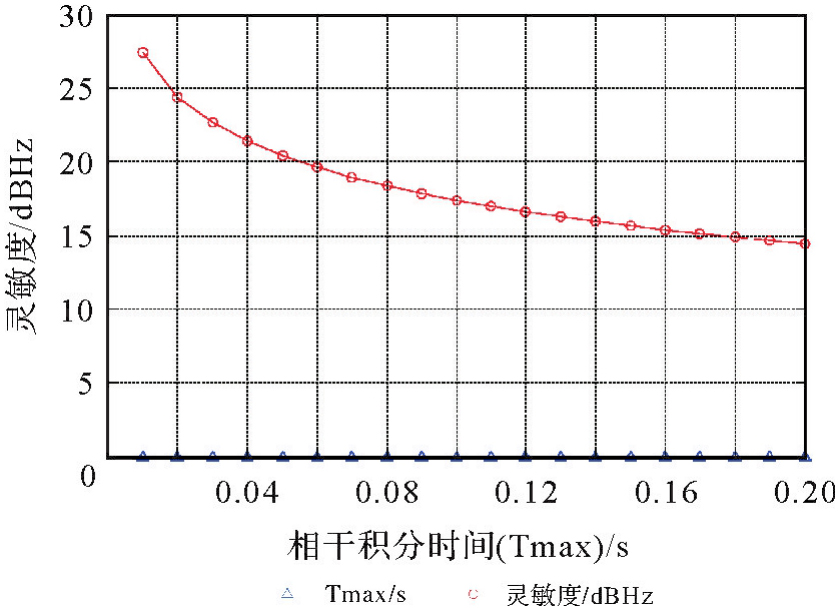
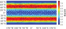
Fig. 13
LEO constellation coverage capability"

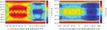
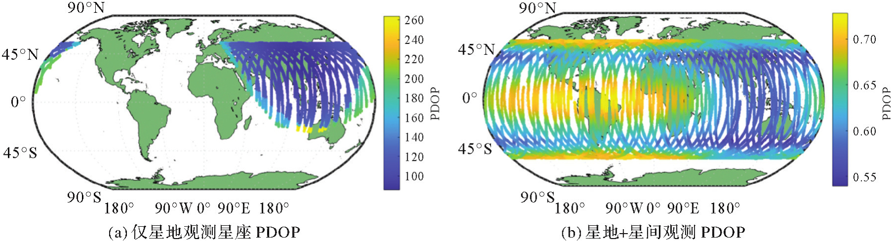
Fig. 14
Comparison of the global mean PDOP values before and after the addition of LEO constellation"
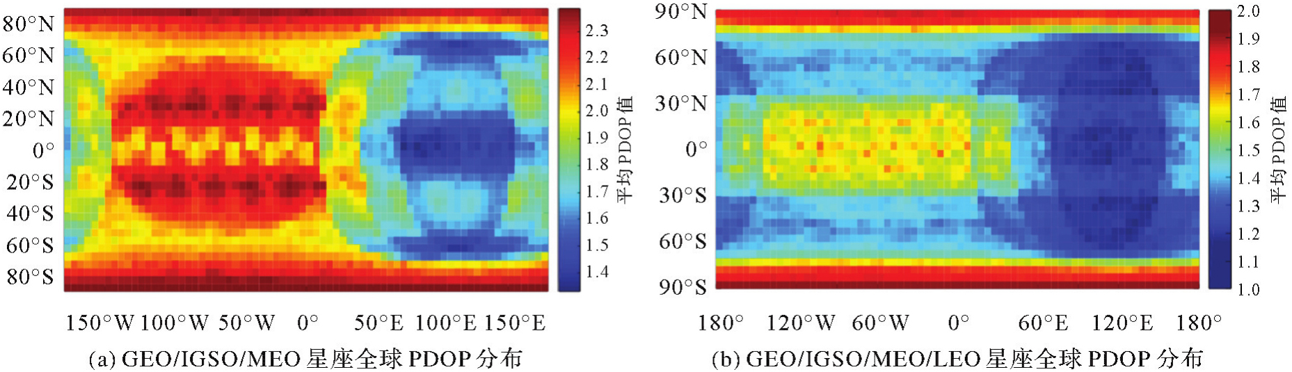
Tab. 13
PDOP values before and after the addition of LEO constellation"
| 星座 | PDOP最大值 | PDOP最小值 | PDOP平均值 |
|---|---|---|---|
| 3GEO+3IGSO+24MEO | 2.39 | 1.13 | 1.99 |
| 3GEO+3IGSO+24MEO+150LEO | 1.93 | 1.10 | 1.48 |

Fig. 15
Monitoring stations distribution"
Fig. 16
Comparison of PDOP values of the constellation before and after the addition of ISL"
Tab. 14
Comparison of the POD solutions with only satellite-ground observations and with satellite-ground and inter-satellite link observations"
| 参数 | 仅星地观测多星定轨 | 星地星间联合多星定轨 |
|---|---|---|
| 观测数据 | 星地伪距相位数据 | 星地伪距相位数据,星间链路数据 |
| 定轨弧段 | 3 d | 3 d |
| 动力学模型 | 二体运动、地球非球形引力、日月引力、太阳辐射压、固体潮、海潮摄动和相对论摄动 | |
| 太阳辐射压参数 | 伯尔尼模型5参数(D、Y、B方向常数加速度及B方向正、余弦加速度) | |
| 截止高度角 | 10° | |
| 卫星天线相位偏差 | 仅考虑PCO和名义姿态 | |
| 大气参数 | 4 h解一组 | 4 h解一组 |
| 钟差处理 | 固定主站站钟,解算其他钟差 | 固定主站站钟,解算其他钟差 |
| 数据权重 | 伪距∶相位=1∶10 000 | 伪距∶相位∶星间数据=1∶10 000∶100 |
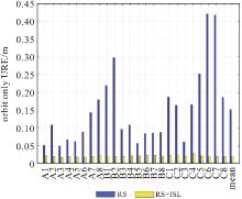
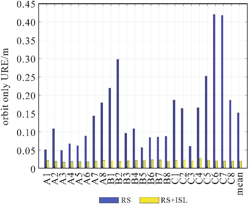
Fig. 17
URE statistical results of different satellite orbits"
Tab. 15
Simulation conditions for the space-based spatio-temporal references solution"
| 设备名称 | 核心指标名称 | 仿真参数设置 |
|---|---|---|
| 星载原子钟 | 稳定度 | (2E-15)/d |
| 星间测量设备 | 时间比对附加不稳定度 | 3 ps@1 s |
| 测距精度 | 优于1 mm(1σ) | |
| 星地测量设备 | 时间比对附加不稳定度 | 10 ps@1 s |
| 测距精度 | 优于3 mm(1σ) | |
| 观星相机 | 惯性空间指向测量精度 | 优于5 mas(1σ) |
| 低轨卫星 | 星座数量 | 大于60颗 |
| 监测接收机定位精度 | 优于30 cm |
Tab. 16
Simulation conclusions for the space-based spatio-temporal reference solution"
| 对象 | 基于设计方案的仿真条件 | 能力增量 | 架构贡献 |
|---|---|---|---|
| GEO/IGSO | 1. 6颗GEO/IGSO增配“1主+1备”汞离子钟/积分球钟; 2. 3颗IGSO卫星配置大面阵观星相机和星地测量设备 | 1. 天基综合原子时天稳优于1E-15; 2. 实现卫星星座空间定向与北斗坐标系、国际天球坐标系的一致性优于8 mas | 1. 大大降低导航系统对地面的依赖。在保持服务性能指标不变条件下,导航电文上注频度由现有1 h/次可提升至7 d/次;在180 d无地面上注的条件下,时间偏差优于50 ns; 2. 提升天基时间基准服务能力,星间/星地时间同步精度提升1~2个数量级,提升PNT精度 |
| MEO | 1. 配置星间测量设备和星地测量设备; 2. 6颗MEO配置信标光,与激光链路共轴 | 星间时间同步精度可提升至0.04 ns | |
| LEO | 配置导航监测接收机 | 具备天基故障自主完好性监测与隔离能力 | |
| 地面锚固站 | 3个锚固站配置星地测量设备 | 星地时间同步精度提升至0.3 ns |
Tab. 17
Simulation strategy for ground observation data"
| 误差类型 | 仿真策略 |
|---|---|
| 中轨轨道钟差 | 固定为仿真轨道钟差 |
| 轨道增加周期项系统误差,钟差增加随机误差 | |
| 低轨卫星轨道钟差 | 固定为仿真轨道钟差 |
| 轨道增加周期项系统误差,钟差增加随机误差 | |
| 电离层误差 | GIM内插,高度角相关映射函数 |
| 对流层误差 | Saastamonen模型,VMF映射函数 |
| 接收机钟差 | 随机量,绝对量在1μs内 |
| 相对论效应 | 考虑,理论公式计算 |
| 相位缠绕误差 | 考虑,理论公式计算 |
| 测站位移 | 考虑,IERS模型计算 |
| 相位噪声 | 2.0 mm |
| 伪距噪声 | 0.4 m |
Tab. 18
Statistics of MEO and MEO+LEO precise point positioning accuracy and convergence time"
| 测站名 | MEO | MEO+LEO | ||||||
|---|---|---|---|---|---|---|---|---|
| E/mm | N/mm | U/mm | 时间/s | E/mm | N/mm | U/mm | 时间/s | |
| CMUM | 37.2 | 14.9 | 26.3 | 482 | 9.9 | 9.9 | 10 | 23 |
| DJIG | 20.7 | 15.1 | 39.8 | 386 | 13.1 | 6.7 | 13.4 | 45 |
| EUSM | 32.6 | 18.6 | 20.9 | 827 | 13 | 7.1 | 17.7 | 39 |
| HKSL | 29.4 | 7.8 | 37.2 | 630 | 9.2 | 6.3 | 13.2 | 24 |
| HLAR | 9.7 | 28.2 | 27.4 | 1088 | 5.3 | 6.7 | 11.5 | 43 |
| KOUR | 17.8 | 15.4 | 38.4 | 1247 | 10 | 7.4 | 23.3 | 32 |
| KZN2 | 15 | 17.1 | 17.8 | 582 | 9 | 9.2 | 13.7 | 26 |
| LHAZ | 20.4 | 17.3 | 63.4 | 1633 | 7.2 | 12.2 | 17.3 | 51 |
| MOBS | 14.5 | 9 | 30.2 | 806 | 8 | 4.6 | 10.6 | 19 |
| RGDG | 19.2 | 21.4 | 43.1 | 1732 | 7.6 | 16.3 | 11.5 | 29 |
| UCAL | 16.3 | 13.1 | 21.5 | 934 | 3.8 | 12.3 | 16.9 | 19 |
| USN8 | 18.7 | 15.6 | 25.3 | 1068 | 12.7 | 6.9 | 12.5 | 17 |
| WUHN | 24.8 | 14.9 | 21 | 582 | 11.6 | 6.1 | 12 | 22 |
| 平均 | 21.3 | 16.0 | 31.7 | 922.8 | 9.3 | 8.6 | 14.1 | 29.9 |
Fig. 18
Comparison of the precise point positioning accuracy and convergence time (at the CMUM station) of MEO and MEO+LEO"
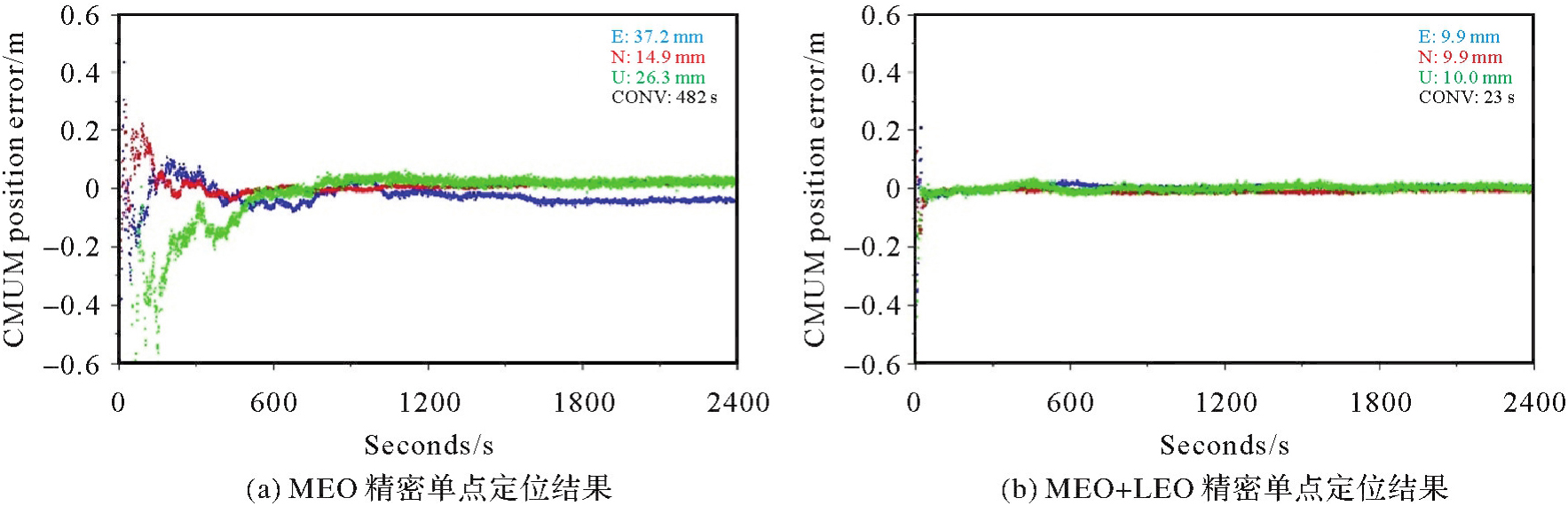
Fig. 19
The enhanced trust of GNSS"
Tab. 19
Comparison of the landing powers of the LEO and MEO transmit signals"
| 对比参数 | LEO | MEO |
|---|---|---|
| 轨道高度 | 1000 km | 25 000 km |
| 卫星发射EIRP值 | 32 dBW | |
| 信号频率 | L1(1 575.42 MHz) | |
| 落地计算位置 | 星下点(仰角90°) | |
| 空间损耗 | 156.3 dB | 184.3 dB |
| 落地功率 | -124.3 d BW | -152.3 dBW |
Tab. 20
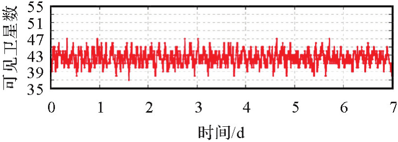
Statistics of the number of LEO satellite observed by the MEO and GEO/IGSO satellites (elevation mask: 10°)"
| 卫星 | 最小可见卫星数 | 最大可见卫星数 | 平均可见卫星数 |
|---|---|---|---|
| MEO | 37 | 48 | 42.3 |
| IGSO | 43 | 54 | 48.9 |
| GEO | 44 | 55 | 50.2 |
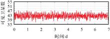
Fig. 20
Time series of the number of visible LEO satellite from the view of the MEO satellite (elevation mask: 10°)"
Tab. 21
Improvements of the new GNSS architecture compared to the existing GNSS architecture"
| 架构能力 | 能力指标 | 现有GNSS架构能力 | 新型GNSS架构能力 |
|---|---|---|---|
| 精准 | 定位精度 | 载波相位定位10 cm以内,收敛时间15~30 min | 5 cm以内,收敛时间1 min |
| 定轨精度 | 星地观测15.1 cm | 星地星间联合观测2.0 cm | |
| 可信 | 落地功率(L1频率) | -152.3 dBW | -124.3 dBW |
| 可用性、连续性 | 遮蔽环境下性能差 | 抬高信号功率,提升遮蔽环境性能星座覆盖重数提升3~7重 | |
| 防欺骗 | 弱 | 增加电文认证,提高防欺骗能力 | |
| 抗干扰 | 弱 | 抬高信号功率,提升抗干扰能力 | |
| 完好性 | 区域CAT-1 | 全球CAT-1 | |
| 韧性 | 中高轨星座出现大量卫星异常时,系统难以正常服务 | 观测几何冗余与强度提升,低轨可独立定位 | |
| 便捷 | — | 碎片化、高成本,依赖外部通信系统 | 一体化、终端低成本,不依赖外部通信系统 |
| 高效 | — | 依赖全球广域/密集地面站 | 基于少量地面站 |
| [1] | YANG Yuanxi, TANG Jing, MONTENBRUCK O. Chinese navigation satellite systems[M]//Springer handbook of global navigation satellite systems. Cham: Springer International Publishing, 2017: 273-304. |
| [2] | LU Jun, GUO Xia, SU Chengeng. Global capabilities of BeiDou navigation satellite system[J]. Satellite Navigation, 2020, 1(1): 27. |
| [3] | MONTENBRUCK O, STEIGENBERGER P, HAUSCHILD A. Comparing the ‘Big 4’-a user's view on GNSS performance[C]//Proceedings of 2020 IEEE/ION Position, Location and Navigation Symposium. Portland: IEEE, 2020: 407-418. |
| [4] | NAVAC. White paper on PNT vision 2035[R]. [S.l.]: The Navigation Innovation Support Programme Advisory Committee, 2024. |
| [5] | SHAO Bo, DING Qun, WU Xianbing. Estimation method of SBAS dual-frequency range error integrity parameter[J]. Satellite Navigation, 2020, 1(1): 9. |
| [6] | CHEN Junping, ZHANG Yize, YU Chao, et al. Models and performance of SBAS and PPP of BDS[J]. Satellite Navigation, 2022, 3(1): 4. |
| [7] | CAI Y. Positioning precision test of national BeiDou ground-based augmentation system[C]//Proceedings of the 10th China Satellite Navigation Conference. Beijing: Springer, 2024. |
| [8] | GENG Y. R&D of ground-based augmentation system (GBAS)[C]//Proceedings of the 10th China Satellite Navigation Conference. Beijing: Springer, 2024. |
| [9] | LI Rui, ZHENG Shuaiyong, WANG Ershen, et al. Advances in BeiDou navigation satellite system (BDS) and satellite navigation augmentation technologies[J]. Satellite Navigation, 2020, 1(1): 12. |
| [10] | 郭树人, 刘成, 高为广, 等. 卫星导航增强系统建设与发展[J]. 全球定位系统, 2019, 44(2): 1-12. |
| GUO Shuren, LIU Cheng, GAO Weiguang, et al. Construction and development of satellite navigation augmentation systems[J]. GNSS World of China, 2019, 44(2): 1-12. | |
| [11] | 杨元喜, 杨诚, 任夏. PNT智能服务[J]. 测绘学报, 2021, 50(8): 1006-1012. DOI: 10.11947/j.AGCS.2021.20210051. |
| YANG Yuanxi, YANG Cheng, REN Xia. PNT intelligent services[J]. Acta Geodaetica et Cartographica Sinica, 2021, 50(8): 1006-1012. DOI: 10.11947/j.AGCS.2021.20210051. | |
| [12] | 郭树人, 姜坤, 李星, 等. PNT体系视角下卫星导航与不依赖卫星导航技术融合发展研究[J]. 中国工程科学, 2023, 25(2): 50-58. |
| GUO Shuren, JIANG Kun, LI Xing, et al. Integrated development of satellite and satellite-independent navigation technologies from the perspective of PNT system[J]. Strategic Study of CAE, 2023, 25(2): 50-58. | |
| [13] | 杨元喜. 综合PNT体系及其关键技术[J]. 测绘学报, 2016, 45(5): 505-510. DOI: 10.11947/j.AGCS.2016.20160127. |
| YANG Yuanxi. Concepts of comprehensive PNT and related key technologies[J]. Acta Geodaetica et Cartographica Sinica, 2016, 45(5): 505-510. DOI: 10.11947/j.AGCS.2016.20160127. | |
| [14] | 杨元喜. 弹性PNT基本框架[J]. 测绘学报, 2018, 47(7): 893-898. DOI: 10.11947/j.AGCS.2018.20180149. |
| YANG Yuanxi. Resilient PNT concept frame[J]. Acta Geodaetica et Cartographica Sinica, 2018, 47(7): 893-898. DOI: 10.11947/j.AGCS.2018.20180149. | |
| [15] | YANG Yuanxi, YAO Zheng, MAO Yue, et al. Resilient satellite-based PNT system design and key technologies[J]. Science China Earth Sciences, 2025, 68(3): 669-682. |
| [16] | HEIN G W. Status, perspectives and trends of satellite navigation[J]. Satellite Navigation, 2020, 1(1): 22. |
| [17] | GE Haibo, LI Bofeng, GE Maorong, et al. Initial assessment of precise point positioning with LEO enhanced global navigation satellite systems (LeGNSS)[J]. Remote Sensing, 2018, 10(7): 984. |
| [18] | MENG Yansong, BIAN Lang, HAN Lin, et al. A global navigation augmentation system based on LEO communication constellation[C]//Proceedings of 2018 European Navigation Conference. Gothenburg: IEEE, 2018: 65-71. |
| [19] | LI Xingxing, MA Fujian, LI Xin, et al. LEO constellation-augmented multi-GNSS for rapid PPP convergence[J]. Journal of Geodesy, 2019, 93(5): 749-764. |
| [20] | GÜNTHER C. Kepler-satellite navigation without clocks and ground infrastructure[C]//Proceedings of 2018 International Technical Meeting of the Satellite Division of the Institute of Navigation. Miami: IEEE, 2018: 849-856. |
| [21] | GIORGI G, SCHMIDT T D, TRAINOTTI C, et al. Advanced technologies for satellite navigation and geodesy[J]. Advances in Space Research, 2019, 64(6): 1256-1273. |
| [22] | RIES L, LIMON M C, GREC F C, et al. LEO-PNT for augmenting Europe's space-based PNT capabilities[C]//Proceedings of 2023 IEEE/ION Position, Location and Navigation Symposium. Monterey: IEEE, 2023: 329-337. |
| [23] | YANG Yuanxi, GAO Weiguang, GUO Shuren, et al. Introduction to BeiDou-3 navigation satellite system[J]. Navigation, 2019, 66(1): 7-18. |
| [24] | 郭树人, 蔡洪亮, 孟轶男, 等. 北斗三号导航定位技术体制与服务性能[J]. 测绘学报, 2019, 48(7): 810-821. DOI: 10.11947/j.AGCS.2019.20190091. |
| GUO Shuren, CAI Hongliang, MENG Yinan, et al. BDS-3 RNSS technical characteristics and service performance[J]. Acta Geodaetica et Cartographica Sinica, 2019, 48(7): 810-821. DOI: 10.11947/j.AGCS.2019.20190091. | |
| [25] | 蔡洪亮, 孟轶男, 耿长江, 等. 北斗三号全球导航卫星系统服务性能评估:定位导航授时、星基增强、精密单点定位、短报文通信与国际搜救[J]. 测绘学报, 2021, 50(4): 427-435. DOI: 10.11947/j.AGCS.2021.20200549. |
| CAI Hongliang, MENG Yinan, GENG Changjiang, et al. BDS-3 performance assessment: PNT, SBAS, PPP, SMC and SAR[J]. Acta Geodaetica et Cartographica Sinica, 2021, 50(4): 427-435. DOI: 10.11947/j.AGCS.2021.20200549. | |
| [26] | SUN Leyuan, WANG Yueke, HUANG Wende, et al. Inter-satellite communication and ranging link assignment for navigation satellite systems[J]. GPS Solutions, 2018, 22(2): 38. |
| [27] | XIE Xin, GENG Tao, ZHAO Qile, et al. Orbit and clock analysis of BDS-3 satellites using inter-satellite link observations[J]. Journal of Geodesy, 2020, 94(7): 64. |
| [28] | FERNÁNDEZ F A. Inter-satellite ranging and inter-satellite communication links for enhancing GNSS satellite broadcast navigation data[J]. Advances in Space Research, 2011, 47(5): 786-801. |
| [29] | KAPLAN E D, HEGARTY C. Understanding GPS/GNSS: principles and applications[M]. 3rd ed. Artech House: Norwood, 2017. |
| [30] | MISRA P, ENGE P. Global positioning system: signals, measurement and performance[M]. 2nd ed. Lincoln: Ganga-Jamuna Press, 2011. |
| [31] | DOW J M, NEILAN R E, RIZOS C. The international GNSS service in a changing landscape of global navigation satellite systems[J]. Journal of Geodesy, 2009, 83(3): 191-198. |
| [32] | WANG Ningbo, LI Zishen, LI Min, et al. GPS, BDS and Galileo ionospheric correction models: an evaluation in range delay and position domain[J]. Journal of Atmospheric and Solar-Terrestrial Physics, 2018, 170: 83-91. |
| [33] | MARTIN H. GPS modernization, interoperability & GNSS space service volume[C]//Proceedings of the 11th Meeting of the International Committee on Global Navigation Satellite Systems. Sochi: IEEE, 2016. |
| [34] | EUSPA (2024) EO and GNSS Market Report 2024[EB/OL]. [2025-07-15]. http://www.euspa.europa.eu. |
| [35] | RISDE (2008) Global navigation satellite system GLONASS interface control document navigational radio signal in bands L1, L2 (Edition 5.1)[EB/OL]. [2025-06-21]. https://www.unavco.org/help/glossary/docs/ICD_GLONASS_5.1_(2008)_en.pdf. |
| [36] | EU (2016) European GNSS (Galileo) open service signal-in-space interface control document issue 1.3[EB/OL]. [2025-08-02]. https://www.gsc-europa.eu/system/files/galileo_documents/galileo-os-sis-icd.pdf. |
| [37] | 中国卫星导航系统管理办公室. 北斗卫星导航系统公开信号接口控制文件公开服务信号B1C(1.0版)[EB/OL]. [2017-12-27]. http://www.beidou.gov.cn. |
| China Satellite Navigation System Management Office. BeiDou navigation satellite system signal in space interface control document open service signal B1C (version 1.0)[EB/OL]. [2017-12-27]. http://www.beidou.gov.cn. | |
| [38] | 中国卫星导航系统管理办公室. 北斗卫星导航系统公开信号接口控制文件公开服务信号B2a (1.0版)[EB/OL]. [2017-12-27]. http://www.beidou.gov.cn. |
| China Satellite Navigation System Management Office. BeiDou navigation satellite system signal in space interface control document open service signal B2a (version 1.0)[EB/OL]. [2017-12-27]. http://www.beidou.gov.cn. | |
| [39] | IS-GPS-200M (2021) Interface specification IS-GPS-200: navstar GPS space segment/navigation user segment interfaces[R]. Los Angeles: Global Positioning Systems Directorate, 2021. |
| [40] | MEI L, BAO Y. Analysis of GNSS interference and anti-jamming technique[J]. China Radio, 2021, 7(1): 58-60. |
| [41] | SU H. Precise orbit determination of global navigation satellite system of second generation (GNSS-2): orbit determination of IGSO, GEO and MEO satellites (doctoral dissertation)[D]. München: University of Bundeswehr München, 2020. |
| [42] | PROL F S, FERRE R M, SALEEM Z, et al. Position, navigation, and timing (PNT) through low earth orbit (LEO) satellites: a survey on current status, challenges, and opportunities[J]. IEEE Access, 2022, 10: 83971-84002. |
| [43] | ANDERSON P. TrustPoint system/service overview[C]//Proceedings of 2023 Workshop on Low Earth Orbit (LEO) PNT Systems Supporting International Committee on GNSS (ICG). Vienna: United Nations Office for Outer Affairs, 2023. |
| [44] | ENGE P, WALTER T, PULLEN S, et al. Wide area augmentation of the global positioning system[J]. Proceedings of the IEEE, 1996, 84(8): 1063-1088. |
| [45] | ZUMBERGE J F, HEFLIN M B, JEFFERSON D C, et al. Precise point positioning for the efficient and robust analysis of GPS data from large networks[J]. Journal of Geophysical Research: Solid Earth, 1997, 102(B3): 5005-5017. |
| [46] | BENEDICTO J, MICHEL P, VENTURA-TRAVESET J. EGNOS: project status overview[J]. Air & Space Europe, 1999, 1(1): 58-64. |
| [47] | RIZOS C, HAN S. Reference station network based RTK systems-concepts and progress[J]. Wuhan University Journal of Natural Sciences, 2003, 8(2): 566-574. |
| [48] | BENZERROUK H. Iridium next LEO satellites as an alternative PNT in GNSS denied environments[J]. Inside GNSS, 2019, 14(4): 56-62. |
| [49] | MONTENBRUCK O, STEIGENBERGER P, HAUSCHILD A. Broadcast versus precise ephemerides: a multi-GNSS perspective[J]. GPS Solutions, 2015, 19(2): 321-333. |
| [50] | BURT E A, PRESTAGE J D, TJOELKER R L, et al. Demonstration of a trapped-ion atomic clock in space[J]. Nature, 2021, 595(7865): 43-47. |
| [51] | FABRICIO S, PROL, KAASALAINEN S, BHUIYAN Z. LEO-PNT as a new system for satellite-based navigatio[C]//Proceedings of 2023 UNOOSA workshop on the Application of GNSS. Vienna: United Nations Office for Outer Space Affairs, 2023. |
| [1] | Deren LI, Mi WANG, Wenbin SHEN, Qingyun DU, Shuo WANG. On the development of surveying and mapping in the era of artificial intelligence [J]. Acta Geodaetica et Cartographica Sinica, 2025, 54(12): 2107-2115. |
| [2] | Xiaoyong SONG, Yuanxi YANG, Yue MAO, Rengui RUAN, Long WANG. Schmidt Kalman filter in autonomous orbit determination of navigation satellites [J]. Acta Geodaetica et Cartographica Sinica, 2024, 53(5): 879-888. |
| [3] | QU Weijing, HUANG Yong, XU Junyi, SUN Shuxian, ZHOU Shanshi, YANG Yufei, HE Bing, HU Xiaogong. Precise orbit determination using satellite laser ranging and inter-satellite link observations for BDS-3 satellites [J]. Acta Geodaetica et Cartographica Sinica, 2023, 52(9): 1437-1448. |
| [4] | YANG Yufei, YANG Yuanxi, CHEN Jinping, TANG Chengpan, LI Chong, GUO Hairong, YANG Jianhua, LIU Jinhuo, YANG Bin. Pseudo-stable constellation bias error of BDS-3 and its high-precision prediction [J]. Acta Geodaetica et Cartographica Sinica, 2021, 50(12): 1728-1737. |
| [5] | LIU Cheng, GAO Weiguang, PAN Junyang, TANG Chengpan, HU Xiaogong, WANG Wei, CHEN Ying, LU Jun, SU Chengeng. Inter-satellite clock offsets adjustment based on closed-loop residual detection of BDS inter-satellite link [J]. Acta Geodaetica et Cartographica Sinica, 2020, 49(9): 1149-1157. |
| [6] | RUAN Rengui, JIA Xiaolin, ZHU Jun, HUYAN Zongbo, FENG Laiping, LI Jie. Integrated orbit determination and time synchronization for BDS-3 satellites with satellite-ground and inter-satellite one-way Ka-pseudoranges [J]. Acta Geodaetica et Cartographica Sinica, 2020, 49(3): 292-299. |
| [7] | YANG Yufei, YANG Yuanxi, HU Xiaogong, TANG Chengpan, ZHAO Liqian, XU Junyi. Comparison and analysis of two orbit determination methods for BDS-3 satellites [J]. Acta Geodaetica et Cartographica Sinica, 2019, 48(7): 831-839. |
| [8] | RUAN Rengui, WEI Ziqing, JIA Xiaolin. BDS-3 satellite orbit and clock determination with one-way inter-satellite pseudorange and monitoring station data [J]. Acta Geodaetica et Cartographica Sinica, 2019, 48(3): 269-275. |
| [9] | CHANG Zhiqiao, HU Xiaogong, CHEN Liucheng, LI Xiaojie, ZU Anran, TANG Chengpan, HUANG Hua. High-accuracy Long Arc Almanac Model Design for BDS [J]. Acta Geodaetica et Cartographica Sinica, 2018, 47(3): 298-307. |
| [10] | SONG Xiaoyong, MAO Yue, FENG Laiping, JIA Xiaolin, JI Jianfeng. The Preliminary Result and Analysis for BD Orbit Determination with Inter-satellite Link Data [J]. Acta Geodaetica et Cartographica Sinica, 2017, 46(5): 547-553. |
| [11] | FENG Laiping, MAO Yue, SONG Xiaoyong, SUN Bijiao. Analysis of the Accuracy of Beidou Combined Orbit Determination Enhanced by LEO and ISL [J]. Acta Geodaetica et Cartographica Sinica, 2016, 45(S2): 109-115. |
| Viewed | ||||||
|
Full text |
|
|||||
|
Abstract |
|
|||||