

Acta Geodaetica et Cartographica Sinica ›› 2025, Vol. 54 ›› Issue (11): 1917-1933.doi: 10.11947/j.AGCS.2025.20250337
• Review • Next Articles
Xiaohua TONG1,2( ), Rong HUANG1,2(), Jiarui CAO1, Chen LIU1, Rong WANG1, Yusheng XU1,2, Zhen YE1,2, Yanmin JIN1,2, Shijie LIU1,2, Sicong LIU1,2, Yongjiu FENG1,2, Huan XIE1,2
Received:2025-09-11
Revised:2025-11-10
Online:2025-12-15
Published:2025-12-15
Contact:
Rong HUANG
E-mail:xhtong@tongji.edu.cn;rong_huang@tongji.edu.cn
About author:TONG Xiaohua (1971—), male, PhD, professor, PhD supervisor, academician of Chinese Academy of Engineering, majors in space mapping and remote sensing for planetary exploration. E-mail: xhtong@tongji.edu.cn
Supported by:CLC Number:
Xiaohua TONG, Rong HUANG, Jiarui CAO, Chen LIU, Rong WANG, Yusheng XU, Zhen YE, Yanmin JIN, Shijie LIU, Sicong LIU, Yongjiu FENG, Huan XIE. Intelligent methods for 3D terrain reconstruction of the Moon and near-Earth planets: a review of current advances and future perspectives[J]. Acta Geodaetica et Cartographica Sinica, 2025, 54(11): 1917-1933.
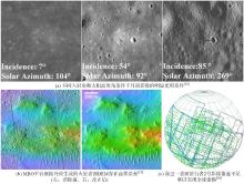
Fig. 1
Typical issues encountered in 3D topographic reconstruction of extraterrestrial bodies"

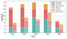
Fig. 2
Publication statistics of existing methods and AI-based methods in major journals over the past five years"
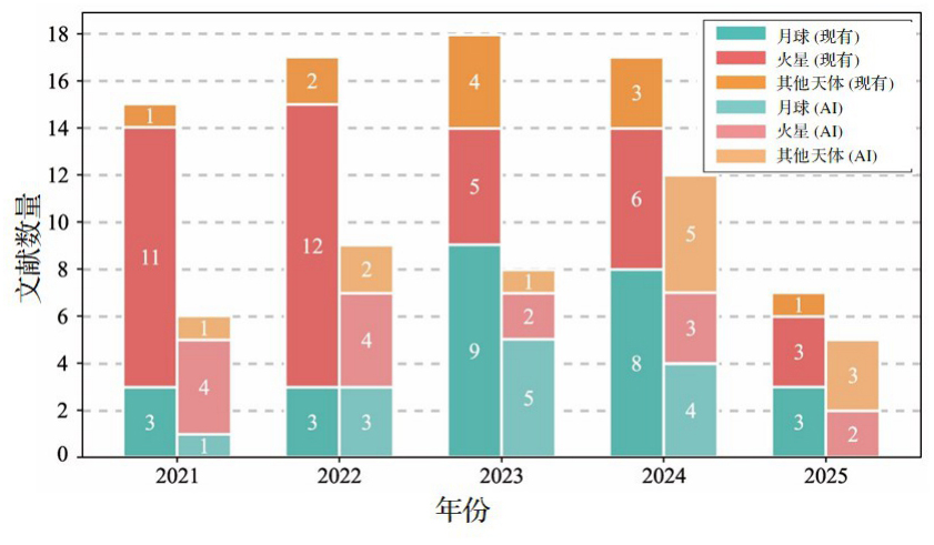
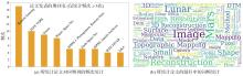
Fig. 3
Frequency statistics of the journals and title keywords of the collected publications"

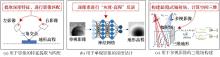
Fig. 4
Comparison of three different technical pathways of artificial intelligence methods for 3D topographic modeling of extraterrestrial bodies"

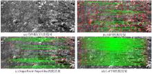
Fig. 5
Matching performance comparison between the traditional algorithm and AI-based methods on Mars CTX images"

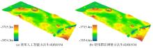
Fig. 6
Comparison of DTMs generated from HiRISE images of the same resolution: single-view reconstruction using an AI-based approach[34] versus multi-view photogrammetric reconstruction (NASA)"
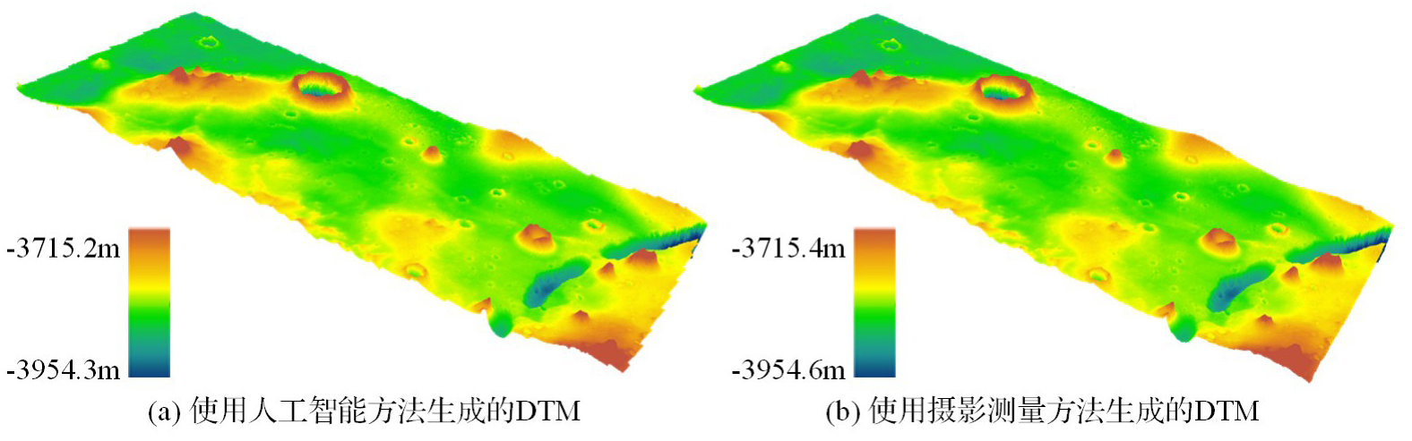
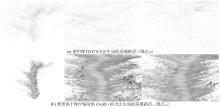
Fig. 7
Comparison of 3D point cloud results reconstructed from navigation camera data acquired by the Perseverance rover, using a traditional MVS method and a NeRF-based approach[47]"

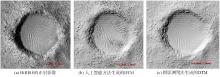
Fig. 8
Comparison of terrain details and surface texture generated by an AI-based reconstruction method[34] and a traditional photogrammetric approach (NASA), using co-registered HiRISE orthoimages for visual reference"

| [1] | 童小华, 刘世杰, 谢欢, 等. 从地球测绘到地外天体测绘[J]. 测绘学报, 2022, 51(4): 488-500. DOI: 10.11947/j.AGCS.2022.20220117. |
| TONG Xiaohua, LIU Shijie, XIE Huan, et al. From Earth mapping to extraterrestrial planet mapping[J]. Acta Geodaetica et Cartographica Sinica, 2022, 51(4): 488-500. DOI: 10.11947/j.AGCS.2022.20220117. | |
| [2] | 刘继忠, 胡朝斌, 庞涪川, 等. 深空探测发展战略研究[J]. 中国科学:技术科学, 2020, 50(9): 1126-1139. |
| LIU Jizhong, HU Chaobin, PANG Fuchuan, et al. Strategy of deep space exploration[J]. Scientia Sinica (Technologica), 2020, 50(9): 1126-1139. | |
| [3] | 张荣桥, 耿言, 孙泽洲, 等. 天问一号任务的技术创新[J]. 航空学报, 2022, 43(3): 626689. |
| ZHANG Rongqiao, GENG Yan, SUN Zezhou, et al. Technical innovations of the Tianwen-1 mission[J]. Acta Aeronautica et Astronautica Sinica, 2022, 43(3): 626689. | |
| [4] | 吴伟仁, 王赤, 刘洋, 等. 深空探测之前沿科学问题探析[J]. 科学通报, 2023, 68(6): 606-627. |
| WU Weiren, WANG Chi, LIU Yang, et al. Frontier scientific questions in deep space exploration[J]. Chinese Science Bulletin, 2023, 68(6): 606-627. | |
| [5] | 李春来, 刘建军, 任鑫, 等. “天问二号”任务科学目标和有效载荷配置[J]. 深空探测学报(中英文), 2024, 11(3): 304-310. |
| LI Chunlai, LIU Jianjun, REN Xin, et al. Scientific objectives and payloads configuration of the Tianwen-2 mission[J]. Journal of Deep Space Exploration, 2024, 11(3): 304-310. | |
| [6] | 裴照宇, 刘继忠, 王倩, 等. 月球探测进展与国际月球科研站[J]. 科学通报, 2020, 65(24): 2577-2586. DOI: 10.1360/TB-2020-0582. |
| PEI Zhaoyu, LIU Jizhong, WANG Qian, et al. Overview of lunar exploration and international lunar research station[J]. Chinese Science Bulletin, 2020, 65(24): 2577-2586. DOI: 10.1360/TB-2020-0582. | |
| [7] | 连丽慧, 胡腾, 康志忠, 等. 行星地质制图历史与制图体系综述[J]. 遥感学报, 2025, 29(2): 373-388. |
| LIAN Lihui, HU Teng, KANG Zhizhong, et al. A review of the history and mapping system of planetary geological mapping[J]. National Remote Sensing Bulletin, 2025, 29(2): 373-388. | |
| [8] | 邸凯昌, 刘斌, 刘召芹. 火星遥感制图技术回顾与展望[J]. 航天器工程, 2018, 27(1): 10-24. |
| DI Kaichang, LIU Bin, LIU Zhaoqin. Review and prospect of Mars mapping technique using remote sensing data[J]. Spacecraft Engineering, 2018, 27(1): 10-24. | |
| [9] | 刘洋, 吴兴, 刘正豪, 等. 火星的地质演化和宜居环境研究进展[J]. 地球与行星物理论评, 2021, 52(4): 416-436. |
| LIU Yang, WU Xing, LIU Zhenghao, et al. Geological evolution and habitable environment of Mars: progress and prospects[J]. Reviews of Geophysics and Planetary Physics, 2021, 52(4): 416-436. | |
| [10] | 柳思聪, 童小华, 刘世杰, 等. “天问一号”着陆区遥感形貌建模与制图分析[J]. 深空探测学报(中英文), 2022, 9(3): 338-347. |
| LIU Sicong, TONG Xiaohua, LIU Shijie, et al. Topography modeling, mapping and analysis of China's first Mars mission Tianwen-1 landing area from remote sensing images[J]. Journal of Deep Space Exploration, 2022, 9(3): 338-347. | |
| [11] | BOATWRIGHT B D, HEAD J W. Shape-from-shading refinement of LOLA and LROC NAC digital elevation models: applications to upcoming human and robotic exploration of the Moon[J]. The Planetary Science Journal, 2024, 5(5): 124-132. |
| [12] | WU Bo, DONG Jie, WANG Yiran, et al. Landing site selection and characterization of Tianwen-1 (Zhurong rover) on Mars[J]. Journal of Geophysical Research: Planets, 2022, 127(4): e2021JE007137. |
| [13] | CHEN Hao, WILLNER K, ZIESE R, et al. Modeling the global shape and surface morphology of the Ryugu asteroid using an improved neural implicit method[J]. Astronomy & Astrophysics, 2025, 696: A212. |
| [14] | XIE Bin, LIU Bin, DI Kaichang, et al. Robust feature matching of multi-illumination lunar orbiter images based on crater neighborhood structure[J]. Remote Sensing, 2025, 17(13): 2302. |
| [15] | MATTSON S, BOYD A, KIRK R L, et al. HiJACK: correcting space-craft jitter in HiRISE images of Mars[J]. Health Manag. Technol, 2009, 33(5): A162. |
| [16] | BLAND M T, MARTIN E S, PATTHOFF A. Increasing the usability and accessibility of Voyager 2 images of Triton[J]. The Planetary Science Journal, 2024, 5(5): 112-124. |
| [17] | LI Zhaojin, WU Bo, LIU W C, et al. Photogrammetric processing of Tianwen-1 HiRIC imagery for precision topographic mapping on Mars[J]. IEEE Transactions on Geoscience and Remote Sensing, 2022, 60: 1-16. |
| [18] | GWINNER K, SCHOLTEN F, SPIEGEL M, et al. Derivation and validation of high-resolution digital terrain models from Mars express HRSC data[J]. Photogrammetric Engineering & Remote Sensing, 2009, 75(9): 1127-1142. |
| [19] | SCHOLTEN F, OBERST J, MATZ K D, et al. GLD100: the near-global lunar 100 m raster DTM from LROC WAC stereo image data[J]. Journal of Geophysical Research: Planets, 2012, 117(E12): E00H17. |
| [20] | HENRIKSEN M R, MANHEIM M R, BURNS K N, et al. Extracting accurate and precise topography from LROC narrow angle camera stereo observations[J]. Icarus, 2017, 283: 122-137. |
| [21] | CHEN Hao, GLÄSER P, HU Xuanyu, et al. ELunarDTMNet: efficient reconstruction of high-resolution lunar DTM from single-view orbiter images[J]. IEEE Transactions on Geoscience and Remote Sensing, 2024, 62: 1-20. |
| [22] | 徐青, 耿迅, 蓝朝桢, 等. 火星地形测绘研究综述[J]. 深空探测学报, 2014, 1(1): 28-35. |
| XU Qing, GENG Xun, LAN Chaozhen, et al. Review of Mars topographic mapping[J]. Journal of Deep Space Exploration, 2014, 1(1): 28-35. | |
| [23] | GRUMPE A, BELKHIR F, WOEHLER C. Construction of lunar DEMs based on reflectance modelling[J]. Advances in Space Research, 2014, 53(12): 1735-1767. |
| [24] | LIU W C, WU Bo. Atmosphere-aware photoclinometry for pixel-wise 3D topographic mapping of Mars[J]. ISPRS Journal of Photogrammetry and Remote Sensing, 2023, 204: 237-256. |
| [25] | LI Zhaojin, WU Bo, LIU W C, et al. Integrated photogrammetric and photoclinometric processing of multiple HRSC images for pixelwise 3D mapping on Mars[J]. IEEE Transactions on Geoscience and Remote Sensing, 2021, 60: 1-13. |
| [26] | QIAN Jia, YE Zhen, QIU Siyi, et al. Secondary scattering shape from shading for precise terrain reconstruction of the lunar permanently shadowed regions[J]. Icarus, 2025, 431: 116494. |
| [27] | 欧阳自远, 肖福根. 火星及其环境[J]. 航天器环境工程, 2012, 29(6): 591-601. |
| OUYANG Ziyuan, XIAO Fugen. The Mars and its environment[J]. Spacecraft Environment Engineering, 2012, 29(6): 591-601. | |
| [28] | 凌宗成, 鞠恩明. 火星表面硫酸盐探测与研究进展[J]. 空间科学与试验学报, 2024, 24(1): 40-53. |
| LING Zongcheng, JU Enming. Research progress in the detection and investigation of sulfates on the Martian surface[J]. Journal of Space Science and Experiment, 2024, 24(1): 40-53. | |
| [29] | LIN S Y, MULLER J P, MILLS J P, et al. An assessment of surface matching for the automated co-registration of MOLA, HRSC and HiRISE DTMs[J]. Earth and Planetary Science Letters, 2010, 294(3/4): 520-533. DOI: 10.1016/j.epsl.2009.12.040. |
| [30] | XIE Huan, LIU Xiaoshuai, XU Yusheng, et al. Using laser altimetry to finely map the permanently shadowed regions of the lunar south pole using an iterative self-constrained adjustment strategy[J]. IEEE Journal of Selected Topics in Applied Earth Observations and Remote Sensing, 2022, 15: 9796-9808. |
| [31] | HUANG Rong, CHEN Chen, WAN Genyi, et al. A novel graph guided global bundle block adjustment of OSIRIS-REx laser altimeter data for topographic mapping of asteroid Bennu[J]. IEEE Transactions on Geoscience and Remote Sensing, 2024, 62: 1-14. |
| [32] | NEUMANN G A, ROWLANDS D D, LEMOINE F G, et al. Crossover analysis of Mars orbiter laser altimeter data[J]. Journal of Geophysical Research: Planets, 2001, 106(E10): 23753-23768. |
| [33] | 赵双明, 李德仁, 牟伶俐. CE-1立体相机影像与激光高度计数据不一致性分析[J]. 测绘学报, 2011, 40(6): 751-755. DOI: 10.13485/j.cnki.11-2089.2014.0178. |
| ZHAO Shuangming, LI Deren, MOU Lingli. Inconsistency analysis of CE-1 stereo camera images and laser altimeter data[J]. Acta Geodaetica et Cartographica Sinica, 2011, 40(6): 751-755. DOI: 10.13485/j.cnki.11-2089.2014.0178. | |
| [34] | CAO Jiarui, HUANG Rong, XU Yusheng, et al. LoGAN: a novel local attentive generative adversarial resizable network for detailed 3D reconstruction of the Martian surface using monocular HiRISE images and DTMs[J]. ISPRS Journal of Photogrammetry and Remote Sensing, 2025, 225: 302-327. |
| [35] | GENG Xun, XU Qing, XING Shuai, et al. A novel pixel-level image matching method for Mars express HRSC linear Pushbroom imagery using approximate orthophotos[J]. Remote Sensing, 2017, 9(12): 1262. |
| [36] | TAO Yu, MICHAEL G, MULLER J P, et al. Seamless 3D image mapping and mosaicing of valles marineris on Mars using orbital HRSC stereo and panchromatic images[J]. Remote Sensing, 2021, 13(7): 1385. |
| [37] | DETONE D, MALISIEWICZ T, RABINOVICH A. Superpoint: self-supervised interest point detection and description[C]//Proceedings of 2018 IEEE Conference on Computer Vision and Pattern Recognition Workshops. Salt Lake City: IEEE, 2018: 224-236. |
| [38] | SUN Jiaming, SHEN Zehong, WANG Yuang, et al. LoFTR: detector-free local feature matching with transformers[C]//Proceedings of 2021 IEEE/CVF Conference on Computer Vision and Pattern Recognition. Nashville: IEEE, 2021: 8922-8931. |
| [39] | CHEN Zeyu, WU Bo, LIU W C. Mars3DNet: CNN-based high-resolution 3D reconstruction of the Martian surface from single images[J]. Remote Sensing, 2021, 13(5): 839. |
| [40] | TAO Yu, XIONG Siting, CONWAY S J, et al. Rapid single image-based DTM estimation from ExoMars TGO CaSSIS images using generative adversarial U-Nets[J]. Remote Sensing, 2021, 13(15): 2877. |
| [41] | TAO Yu, MULLER J P, XIONG S T, et al. MADNet 2.0: pixel-scale topography retrieval from single-view orbital imagery of Mars using deep learning[J]. Remote Sensing, 2021, 13(21): 4220. |
| [42] | CHEN Hao, HU Xuanyu, GLÄSER P, et al. CNN-based large area pixel-resolution topography retrieval from single-view LROC NAC images constrained with SLDEM[J]. IEEE Journal of Selected Topics in Applied Earth Observations and Remote Sensing, 2022, 15: 9398-9416. |
| [43] | LI Zhaojin, WU Bo, CHEN Shihan. 3D Gaussian splatting for detailed reconstruction of planetary surfaces from orbiter images[C]//Proceedings of 2025 EGU General Assembly. Vienna: [s.n.], 2025. |
| [44] | CHEN Hao, HU Xuanyu, WILLNER K, et al. Neural implicit shape modeling for small planetary bodies from multi-view images using a mask-based classification sampling strategy[J]. ISPRS Journal of Photogrammetry and Remote Sensing, 2024, 212: 122-145. |
| [45] | CHEN Min, YAN Jianguo, HUANG Xianfeng, et al. Advancements in the 3D shape reconstruction of Phobos: an analysis of shape models and future exploration directions[J]. Astronomy & Astrophysics, 2024, 684: A89. |
| [46] | GIUSTI L, GARCIA J, COZINE S, et al. MaRF: representing Mars as neural radiance fields[C]//Proceedings of 2022 European Conference on Computer Vision. Cham: Springer, 2022: 53-65. |
| [47] | HUANG Rong, LIU Chen, XIE Huan, et al. Monocular visual SLAM with adjusting neural radiance fields for 3D reconstruction in planetary environments[J]. IEEE Transactions on Geoscience and Remote Sensing, 2025, 63: 1-19. |
| [48] | TAO Yu, WALTER S H G, MULLER J P, et al. A high-resolution digital terrain model mosaic of the Mars 2020 perseverance rover landing site at Jezero crater[J]. Earth and Space Science, 2023, 10(10): e2023EA003045. |
| [49] | DOUTÉ S, JIANG Cheng. Small-scale topographical characterization of the Martian surface with in-orbit imagery[J]. IEEE Transactions on Geoscience and Remote Sensing, 2019, 58(1): 447-460. |
| [50] | BEYER R A, ALEXANDROV O, MCMICHAEL S. The Ames stereo pipeline: NASA's open source software for deriving and processing terrain data[J]. Earth and Space Science, 2018, 5(9): 537-548. |
| [1] | Peng LI, Jiahan ZHANG, Zhihan WANG, Houjie WANG, Zhenhong LI. A review of intertidal topography reconstruction methods: current status, challenges and trends [J]. Acta Geodaetica et Cartographica Sinica, 2026, 55(4): 571-587. |
| [2] | Jiayao WANG, Lin CHEN, Shiyuan CHENG, Lijun WANG, Siqi XIONG. Artificial intelligence empowering the digital-intelligent transformation of cartographic science [J]. Acta Geodaetica et Cartographica Sinica, 2026, 55(3): 381-389. |
| [3] | Chenming YE, Zhizhong KANG, Jinhao CAI, Bingzheng ZUO, Shuai SHAO, Yan LI. A morphology-guided real-scene 3D modeling method of lunar geo-entities [J]. Acta Geodaetica et Cartographica Sinica, 2026, 55(3): 525-535. |
| [4] | Shaohua WANG, Haojian LIANG, Cheng SU, Dachuan XU, Liang ZHOU, Kun QIN. Advances and prospects in urban facility allocation optimization through coupling spatio-temporal big data and artificial intelligence [J]. Acta Geodaetica et Cartographica Sinica, 2026, 55(2): 222-235. |
| [5] | Shunping JI, Jin LIU, Jian GAO, Jianya GONG. An intelligent 3D reconstruction framework via deep learning based multi-view image matching [J]. Acta Geodaetica et Cartographica Sinica, 2025, 54(9): 1633-1646. |
| [6] | Yipeng LU, Yuhao LI, Haiping WANG, Yuan LIU, Zhen DONG, Bisheng YANG. CVT space warping based multi-scale neural implicit surface reconstruction for outdoor scenes [J]. Acta Geodaetica et Cartographica Sinica, 2025, 54(4): 702-713. |
| [7] | Gang LI, Fang XIE, Yifan WU, Jun LU, Shuren GUO, Yingchun LIU, Chengeng SU, Xiaoheng YANG. Prospects for the development of deep space navigation technologies [J]. Acta Geodaetica et Cartographica Sinica, 2025, 54(3): 397-409. |
| [8] | Dong WEI, Xinyi LIU, Yongjun ZHANG. The technology and intelligent development of 3D line cloud reconstruction from multiple images [J]. Acta Geodaetica et Cartographica Sinica, 2024, 53(6): 1025-1036. |
| [9] | Xiaogang NING, Hanchao ZHANG, Ruiqian ZHANG. Practical framework and methodology for high-performance intelligent invariant detection in remote sensing imagery [J]. Acta Geodaetica et Cartographica Sinica, 2024, 53(6): 1098-1112. |
| [10] | JIANG San, LIU Kai, LI Qingquan, JIANG Wanshou. Learned local features for SfM reconstruction of UAV images [J]. Acta Geodaetica et Cartographica Sinica, 2024, 53(2): 321-331. |
| [11] | Jin LIU, Shunping JI. Deep learning based multi-view dense matching with joint depth and surface normal estimation [J]. Acta Geodaetica et Cartographica Sinica, 2024, 53(12): 2391-2403. |
| [12] | Qin YAN, Haiyan GU, Yi YANG, Haitao LI, Hengtong SHEN, Shiqi LIU. Research progress and trend of intelligent remote sensing large model [J]. Acta Geodaetica et Cartographica Sinica, 2024, 53(10): 1967-1980. |
| [13] | LI Shutao, WU Qiong, KANG Xudong. Hyperspectral remote sensing image intrinsic information decomposition: advances and challenges [J]. Acta Geodaetica et Cartographica Sinica, 2023, 52(7): 1059-1073. |
| [14] | CAO Zilong, TONG Xiaohua, XU Xiong, YE Zhen, XIAO Changjiang. Research and ground-based validation on Mars rover localization based on multi-level images matching [J]. Acta Geodaetica et Cartographica Sinica, 2023, 52(4): 579-587. |
| [15] | YANG Bisheng, CHEN Chi, DONG Zhen. 3D geospatial information extraction of urban objects for smart surveying and mapping [J]. Acta Geodaetica et Cartographica Sinica, 2022, 51(7): 1476-1484. |
| Viewed | ||||||
|
Full text |
|
|||||
|
Abstract |
|
|||||