

Acta Geodaetica et Cartographica Sinica ›› 2026, Vol. 55 ›› Issue (4): 684-697.doi: 10.11947/j.AGCS.2026.20250239
• Geodesy and Navigation • Previous Articles Next Articles
Jinwei BU1,2( ), Shuhui LIU1, Shunshuang XU1, Tongsu XIANG1, Qiulan WANG1, Chaoying JI1, Xiaoqing ZUO1,2
Received:2025-07-01
Revised:2026-03-17
Online:2026-05-11
Published:2026-05-11
About author:BU Jinwei (1992—), male, PhD, lecturer, majors in GNSS reflectometry remote sensing. E-mail: b_jinwei@kust.edu.cn
Supported by:CLC Number:
Jinwei BU, Shuhui LIU, Shunshuang XU, Tongsu XIANG, Qiulan WANG, Chaoying JI, Xiaoqing ZUO. Construction of an empirical model for estimating the global wave period of spaceborne GNSS-R[J]. Acta Geodaetica et Cartographica Sinica, 2026, 55(4): 684-697.
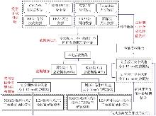
Fig. 1
Data processing and model construction process of spaceborne GNSS-R wave period retrieval"
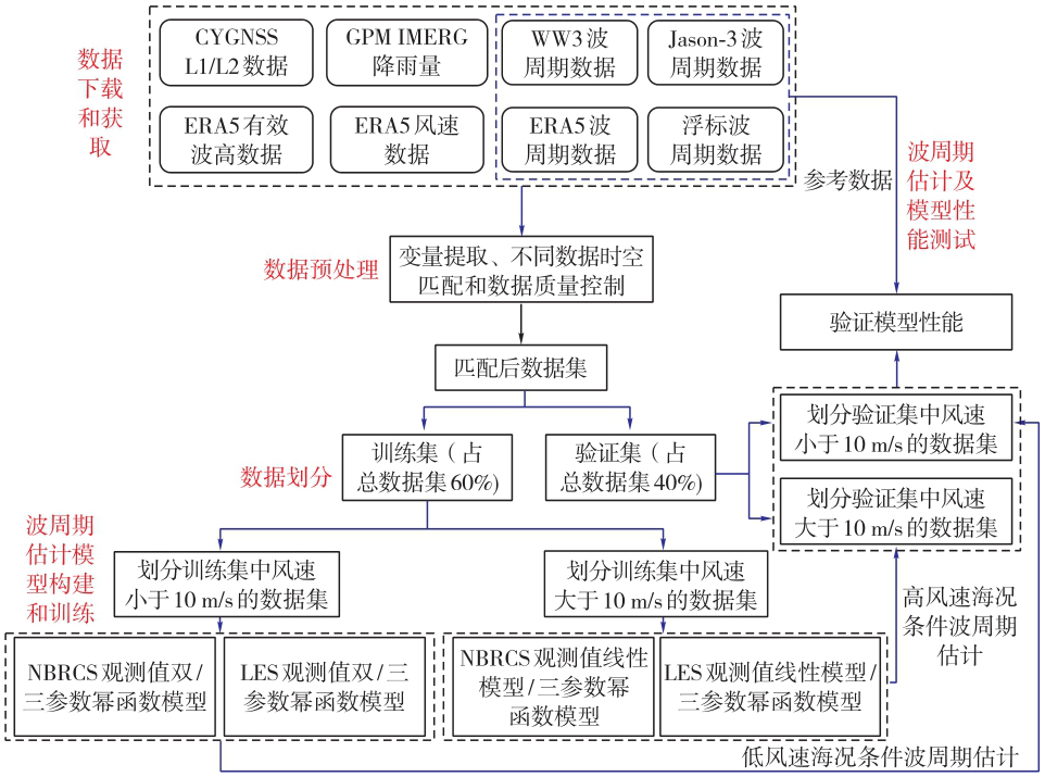
Fig. 2
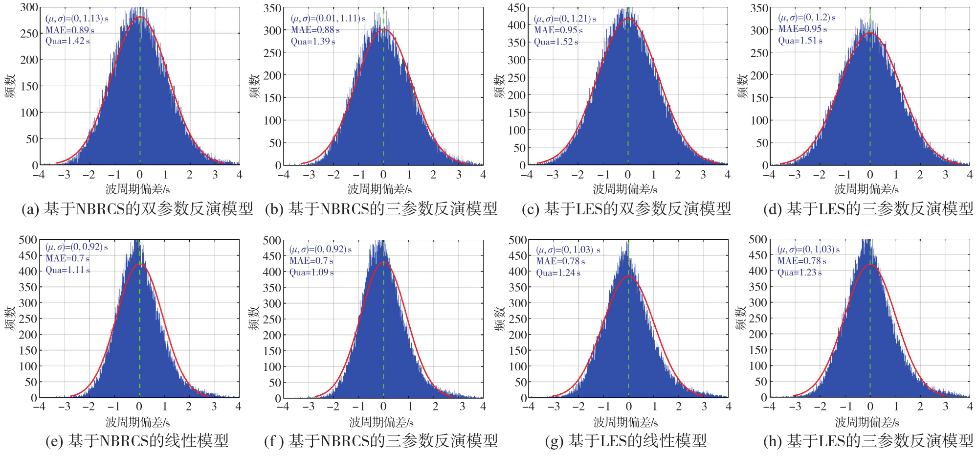
Two parameter power function model and three parameter power function model based on NBRCS and LES observables under low wind speed (<10 m/s) conditions"
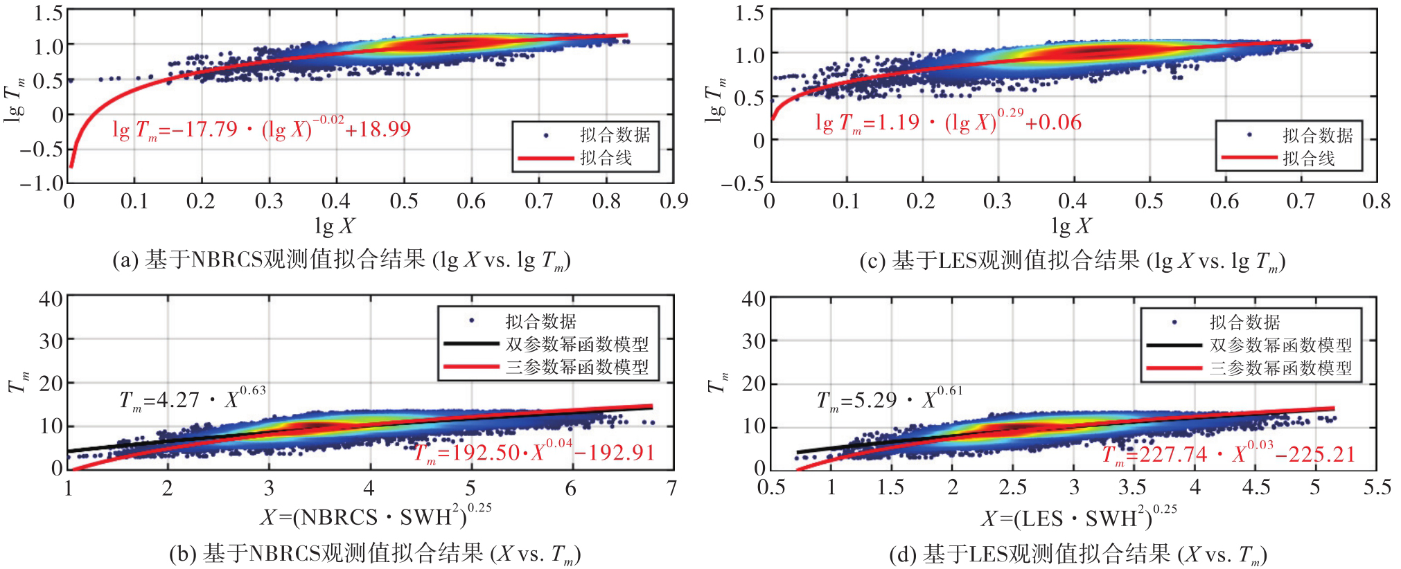
Fig. 3
Linear model and three parameter power function model based on NBRCS and LES observables under high wind speed (>10 m/s) conditions"
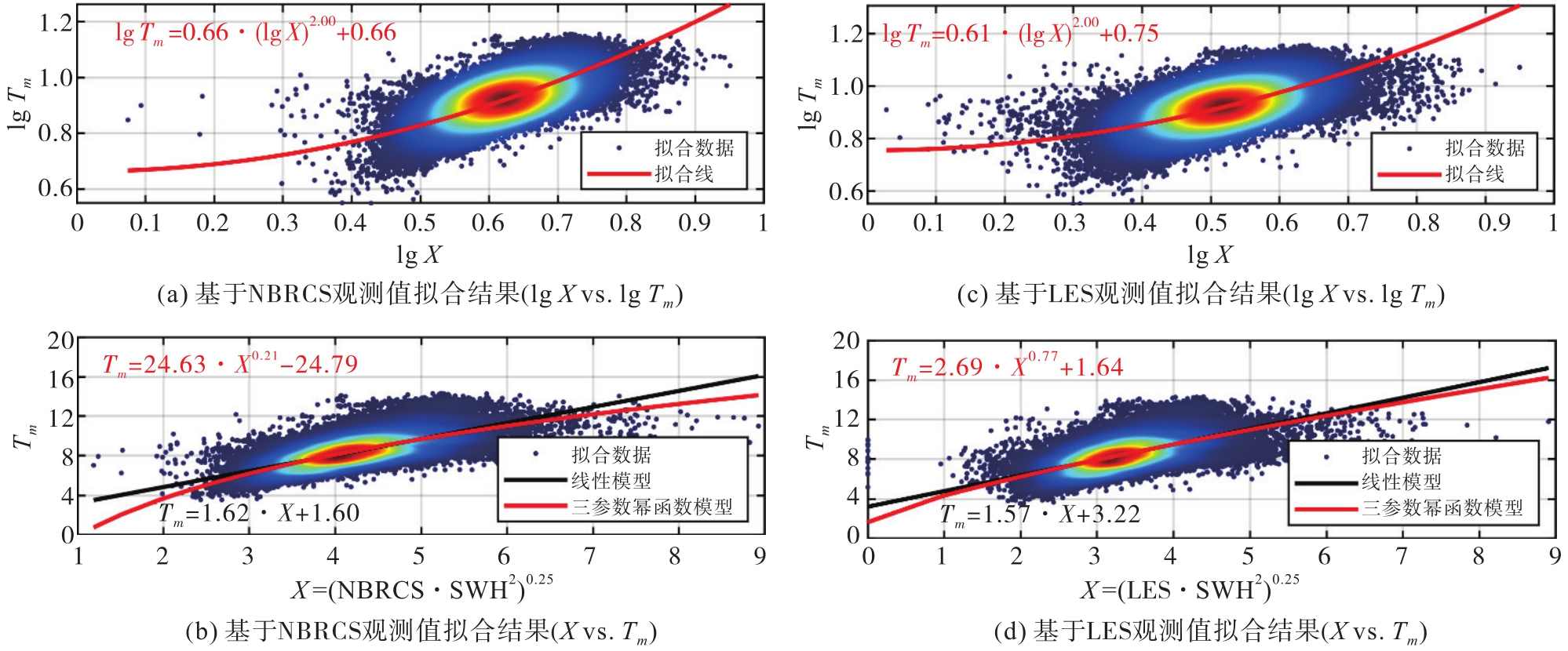
Fig. 4
Comparison results of wave period estimation using different model based on NBRCS and LES observables with ERA5 data (wind speed <10 m/s)"
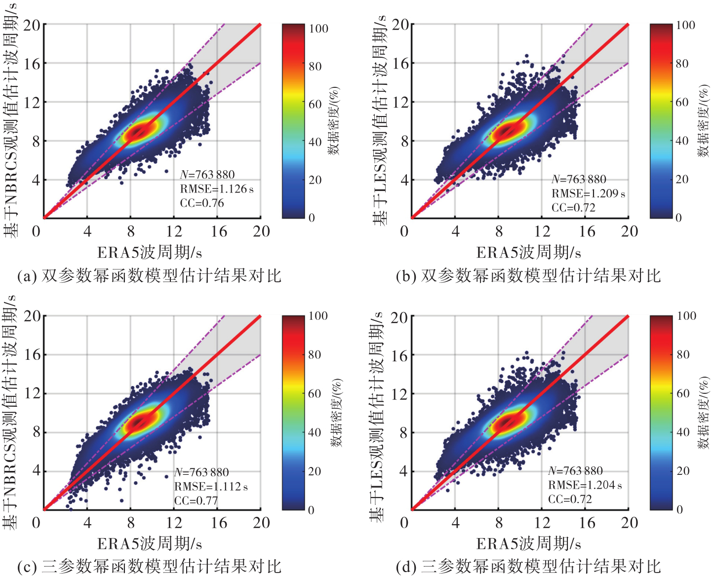
Fig. 5
Comparison results of wave period estimation using different model based on NBRCS and LES observables with ERA5 data (wind speed: 10~25 m/s)"
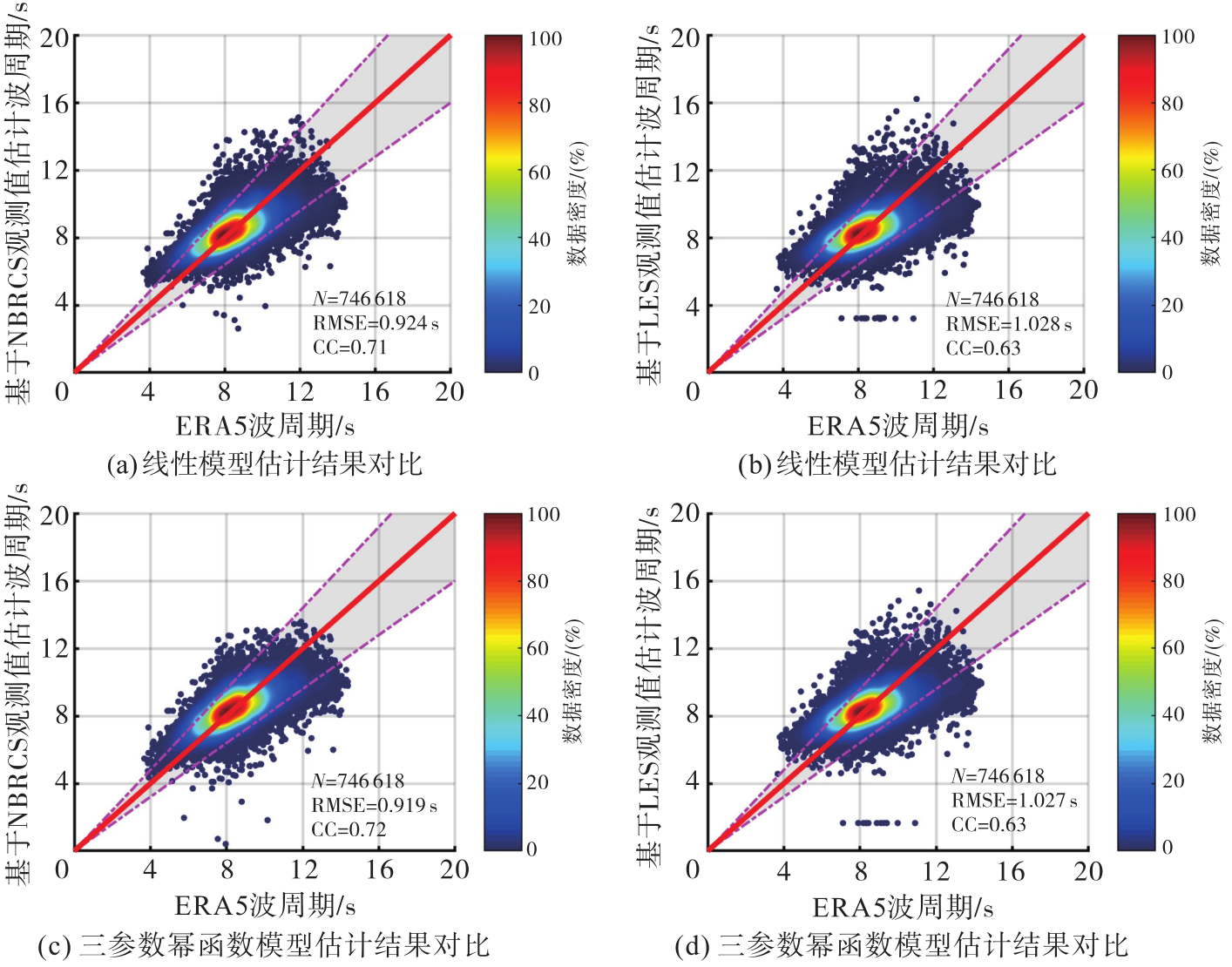
Fig. 6
Global distribution of ERA5 wave period and wave period deviation retrieved by different models at wind speeds of 10~25 m/s"
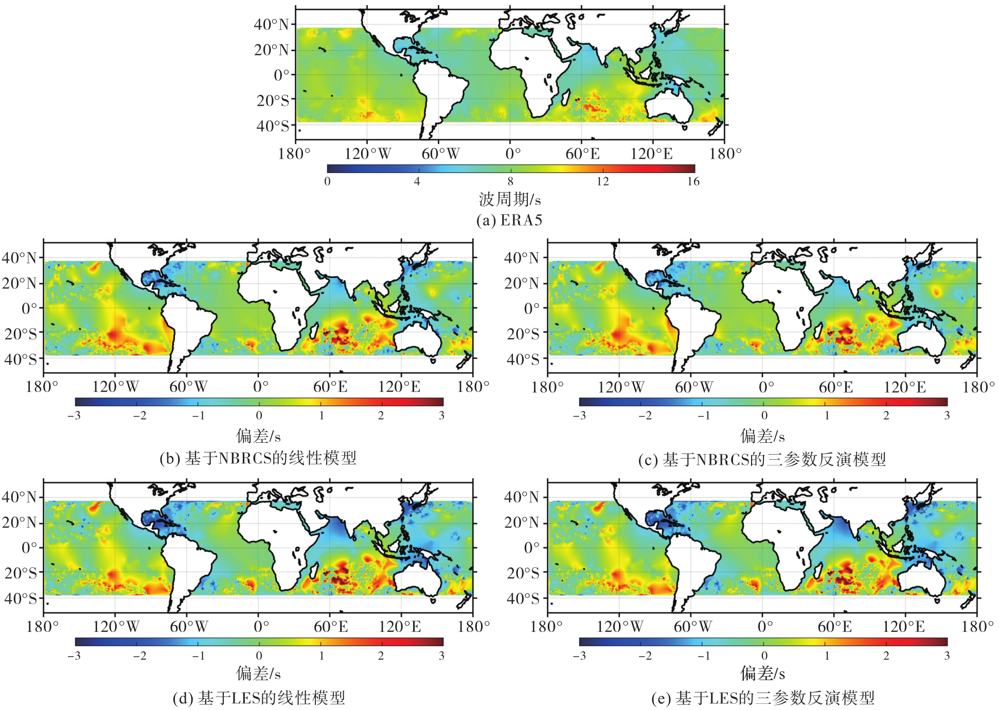
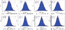
Fig. 7
Histogram of ERA5 wave period and different model retrieval wave period deviation distribution under wind speeds less than 10 m/s (first row) and 10~25 m/s (second row)"
Tab. 1
Accuracy of model estimation of wave period under different wind speeds compared to WW3 data"
| GNSS-R观测值 | 精度指标 | 低风速(<10 m/s) | 高风速(10~25 m/s) | ||
|---|---|---|---|---|---|
| 双参数幂函数 | 三参数幂函数 | 线性模型 | 三参数幂函数 | ||
| NBRCS | RMSE/s | 1.35 | 1.32 | 1.23 | 1.23 |
| Bias/s | 0.03 | -0.01 | 0.03 | -0.01 | |
| CC | 0.62 | 0.64 | 0.59 | 0.60 | |
| MAPE/(%) | 12.36 | 11.87 | 10.73 | 10.68 | |
| LES | RMSE/s | 1.37 | 1.35 | 1.25 | 1.24 |
| Bias/s | 0.03 | 0.00 | 0.03 | -0.01 | |
| CC | 0.60 | 0.62 | 0.58 | 0.58 | |
| MAPE/(%) | 12.57 | 12.17 | 10.85 | 10.76 | |
Tab. 2
Accuracy statistics of model estimation of wave period under different wind speeds compared to Jason-3 data"
| GNSS-R观测值 | 精度指标 | 低风速(<10 m/s) | 高风速(10~25 m/s) | ||
|---|---|---|---|---|---|
| 双参数幂函数 | 三参数幂函数 | 线性模型 | 三参数幂函数 | ||
| NBRCS | RMSE/s | 1.25 | 1.20 | 1.10 | 1.08 |
| Bias/s | 0.04 | -0.03 | 0.03 | -0.02 | |
| CC | 0.70 | 0.72 | 0.74 | 0.75 | |
| MAPE/(%) | 12.50 | 12.0 | 10.80 | 10.50 | |
| LES | RMSE/s | 1.28 | 1.22 | 1.12 | 1.10 |
| Bias/s | 0.04 | 0.02 | 0.03 | -0.03 | |
| CC | 0.68 | 0.70 | 0.72 | 0.73 | |
| MAPE/(%) | 13.00 | 12.50 | 11.20 | 10.90 | |
Tab. 3
Accuracy statistics of model estimation of wave period under different wind speeds compared to buoy data"
| GNSS-R观测值 | 精度指标 | 低风速(<10 m/s) | 高风速(10~25 m/s) | ||
|---|---|---|---|---|---|
| 双参数幂函数 | 三参数幂函数 | 线性模型 | 三参数幂函数 | ||
| NBRCS | RMSE/s | 1.45 | 1.42 | 1.43 | 1.41 |
| Bias/s | 0.04 | -0.02 | 0.05 | -0.02 | |
| CC | 0.58 | 0.60 | 0.55 | 0.56 | |
| MAPE/(%) | 13.50 | 13.01 | 13.80 | 13.52 | |
| LES | RMSE/s | 1.48 | 1.45 | 1.45 | 1.46 |
| Bias/s | 0.04 | 0.01 | 0.07 | -0.04 | |
| CC | 0.56 | 0.57 | 0.54 | 0.53 | |
| MAPE/(%) | 14.01 | 12.53 | 14.21 | 13.10 | |
Tab. 4
Comparison of inversion accuracy between our model and existing models under normal and cyclonic ocean conditions"
| 模型 | 精度指标 | 正常海洋条件(风速<15 m/s) | 气旋海洋条件(风速≥15 m/s) | ||
|---|---|---|---|---|---|
| NBRCS观测值 | LES观测值 | NBRCS观测值 | LES观测值 | ||
| 文献[ | RMSE/s | 1.19 | 1.52 | 1.51 | 1.53 |
| Bias/s | -0.04 | 0.42 | -0.57 | -0.57 | |
| CC | 0.72 | 0.60 | 0.55 | 0.55 | |
| MAPE/(%) | 11.19 | 13.75 | 14.01 | 14.13 | |
| 本文模型 | RMSE/s | 1.09 | 1.27 | 1.33 | 1.38 |
| Bias/s | 0.03 | 0.13 | 0.23 | 0.43 | |
| CC | 0.72 | 0.68 | 0.59 | 0.58 | |
| MAPE/(%) | 11.01 | 12.01 | 13.86 | 13.91 | |
Tab. 5
Accuracy of model estimation wave period and ERA5 wave period data comparison under high wind speed (<10 m/s) and high wind speed (10~25 m/s)"
| GNSS-R观测值 | 精度指标 | 按比例划分验证 | 5折交叉验证 | ||
|---|---|---|---|---|---|
| 双参数幂函数(线性)模型 | 三参数幂函数 | 双参数幂函数(线性)模型 | 三参数幂函数 | ||
| NBRCS | RMSE/s | 1.13(0.93) | 1.11(0.92) | 1.18(0.96) | 1.15(0.96) |
| Bias/s | -0.05(-0.05) | 0.00(0.00) | -0.04(-0.06) | 0.01(-0.02) | |
| CC | 0.75(0.71) | 0.76(0.72) | 0.73(0.68) | 0.75(0.68) | |
| MAPE/(%) | 10.38(8.32) | 10.25(8.35) | 10.98(8.75) | 10.69(8.75) | |
| LES | RMSE/s | 1.22(1.03) | 1.21(1.03) | 1.27(1.08) | 1.25(1.08) |
| Bias/s | -0.05(-0.05) | 0.00(0.00) | -0.04(-0.06) | 0.01(-0.02) | |
| CC | 0.71(0.63) | 0.72(0.63) | 0.68(0.58) | 0.69(0.57) | |
| MAPE/(%) | 11.18(9.29) | 11.21(9.37) | 11.85(9.79) | 11.76(9.88) | |
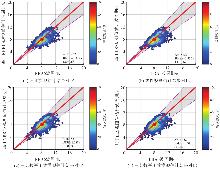
Fig. 8
Scatter density plot of wave period estimation based on NBRCS and LES observables compared to ERA5 data (wind speed: 25~60 m/s)"
Tab. 6
Accuracy of model estimated wave period and ERA5 data comparison under extreme conditions (wind speed >25 m/s)"
| GNSS-R观测值 | 精度指标 | 按比例划分验证 | 5折交叉验证 | ||
|---|---|---|---|---|---|
| 线性模型 | 三参数幂函数 | 线性模型 | 三参数幂函数 | ||
| NBRCS | RMSE/s | 1.16 | 1.15 | 1.21 | 1.21 |
| Bias/s | -0.07 | 0.00 | -0.09 | -0.03 | |
| CC | 0.70 | 0.71 | 0.67 | 0.67 | |
| MAPE/(%) | 10.68 | 10.89 | 11.09 | 11.28 | |
| LES | RMSE/s | 1.16 | 1.15 | 1.21 | 1.21 |
| Bias/s | -0.07 | 0.00 | -0.09 | -0.03 | |
| CC | 0.70 | 0.70 | 0.67 | 0.67 | |
| MAPE/(%) | 10.75 | 10.96 | 11.14 | 11.34 | |
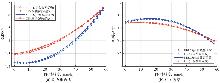
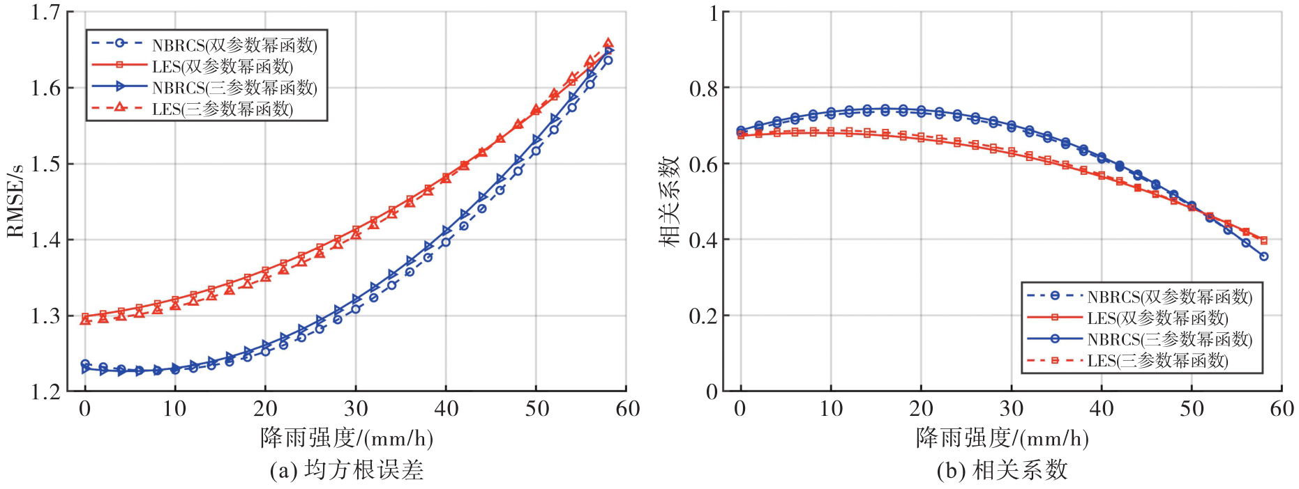
Fig. 9
The impact of sea surface rainfall on the performance of wave period retrieval models based on NBRCS and LES observables"
| [1] | BU J W, YU K, PARK H, et al. Estimation of swell height using spaceborne GNSS-R data from eight CYGNSS satellites[J]. Remote Sensing, 2022, 14(18): 4634. |
| [2] | WANG Q, BU J, NI J, et al. Ocean swell height estimation from spaceborne GNSS-R data using hybrid deep learning model[J]. GPS Solutions, 2024, 28(4): 187. |
| [3] | HW ANG P A, TEAGUE W J, JACOBS G A, et al. A statistical comparison of wind speed, wave height, and wave period derived from satellite altimeters and ocean buoys in the Gulf of Mexico region[J]. Journal of Geophysical Research: Oceans, 1998, 103(C5): 10451-10468. |
| [4] | GOMMENGINGER C, SROKOSZ M, CHALLENOR P, et al. Measuring ocean wave period with satellite altimeters: a simple empirical model[J]. Geophysical Research Letters, 2003, 30(22): 2150. |
| [5] | WANG J, AOUF L, BADULIN S. Retrieval of wave period from altimetry: deep learning accounting for random wave field dynamics[J]. Remote Sensing of Environment, 2021(265): 112629. |
| [6] | ZHAO D, LI S, SONG C. The comparison of altimeter retrieval algorithms of the wind speed and the wave period[J]. Acta Oceanologica Sinica, 2012(31): 1-9. |
| [7] | MACKAY E, RETZLER C, CHALLENOR P, et al. A parametric model for ocean wave period from Ku band altimeter data[J]. Journal of Geophysical Research: Oceans, 2008, 113(C3): C03029. |
| [8] | KSHATRIYA J, SARKAR A, KUMAR R. Determination of ocean wave period from altimeter data using wave-age concept[J]. Marine Geodesy, 2005, 28(1): 71-79. |
| [9] | QUARTLY G, GUYMER T, SROKOSZ M. The effects of rain on Topex radar altimeter data[J]. Journal of Atmospheric and Oceanic Technology, 1996, 13(6): 1209-1229. |
| [10] | BU J, LI H, YU K, et al. Machine learning methods for earth observation and remote sensing using spaceborne GNSS reflectometry: current status, challenges, and future prospects[J]. IEEE Geoscience and Remote Sensing Magazine, 2025(6): 62-66. |
| [11] | CARDELLACH E, LI W, RIUS A, et al. First precise spaceborne sea surface altimetry with GNSS reflected signals[J]. IEEE Journal of Selected Topics in Applied Earth Observations and Remote Sensing, 2020(13): 102-112. |
| [12] | LI W, CARDELLACH E, FABRA F, et al. Assessment of spaceborne GNSS-R ocean altimetry performance using CYGNSS mission raw data[J]. IEEE Transactions on Geoscience and Remote Sensing, 2020, 58(1): 238-250. |
| [13] | LI M, HOU Y, SONG X, et al. Self-attention-guided multi-indicator retrieval for ocean surface wind field with multimodal data augmentation and fusion[J]. IEEE Transactions on Geoscience and Remote Sensing, 2024, 62: 4108822 |
| [14] | BU J W, YU K G, ZUO X, et al. GloWS-Net: a deep learning framework for retrieving global sea surface wind speed using spaceborne GNSS-R data[J]. Remote Sensing, 2023, 15(3): 590. |
| [15] | YAN Q, HUANG W. Spaceborne GNSS-R sea ice detection using delay-doppler maps: first results from the U. K. TechDemoSat-1 mission[J]. IEEE Journal of Selected Topics in Applied Earth Observations and Remote Sensing, 2016, 9(10): 4795-4801. |
| [16] | BU J W, YU K G. Sea surface rainfall detection and intensity retrieval based on GNSS-reflectometry data from the CYGNSS mission[J]. IEEE Transactions on Geoscience and Remote Sensing, 2022(60): 5802015. |
| [17] | BU J W, YU K G, NI J, et al. Machine learning-based methods for sea surface rainfall detection from CYGNSS delay-doppler maps[J]. GPS Solutions, 2022, 26(4): 132. |
| [18] | BU J W, YU K G. Significant wave height retrieval method based on spaceborne GNSS reflectometry[J]. IEEE Geoscience and Remote Sensing Letters, 2022(19): 1503705. |
| [19] | BU J W, WANG Q L, NI J. Estimating sea surface swell height using a hybrid model combining CNN, ConvLSTM, and FCN based on spaceborne GNSS-R data from the CYGNSS mission[J]. GPS Solutions, 2024, 28(3): 133. |
| [20] | REINKING J, ROGGENBUCK O, EVEN-TZUR G. Sea state observation using ground-based GNSS-SNR data[Z]. EGU General Assembly 2020. 2020: EGU2020-2709. |
| [21] | WANG X, HE X, SHI J, et al. Estimating sea level, wind direction, significant wave height, and wave peak period using a geodetic GNSS receiver[J]. Remote Sensing of Environment, 2022, 279: 113135. |
| [22] | MAHESHWARI M, CHAKRABORTY A, KUMAR A, et al. Investigation of the relationship of CYGNSS observables with ocean wave parameters[C]//Proceedings of 2021 IEEE International India Geoscience and Remote Sensing Symposium. Ahmedabad: IEEE, 2021. |
| [23] | HUANG F, GARRISON J L, LEIDNER S M, et al. A forward model for data assimilation of GNSS ocean reflectometry delay-Doppler maps[J]. IEEE Transactions on Geoscience and Remote Sensing, 2021, 59(3): 2643-2656. |
| [24] | ZAVOROTNY V U, VORONOVICH A G. Scattering of GPS signals from the ocean with wind remote sensing application[J]. IEEE Transactions on Geoscience and Remote Sensing, 2000, 38(2): 951-964. |
| [25] | CHEN-ZHANG D D, RUF C S, ARDHUIN F, et al. GNSS-R nonlocal sea state dependencies: model and empirical verification[J]. Journal of Geophysical Research: Oceans, 2016, 121(11): 8379-8394. |
| [26] | GLEASON S, RUF C S, CLARIZIA M P, et al. Calibration and unwrapping of the normalized scattering cross section for the cyclone global navigation satellite system[J]. IEEE Transactions on Geoscience and Remote Sensing, 2016, 54(5): 2495-2509. |
| [27] | SARKAR A, KUMAR R, MOHAN M. Estimation of ocean wave periods by spaceborne altimeters[J]. Oceanographic Literature Review, 1998, 7(45): 1116. |
| [28] | QIU T, ZHENG Q, WANG X, et al. Retrieving ocean surface wind speeds in real time on spaceborne GNSS-R receivers: algorithm and validation[J]. IEEE Journal of Selected Topics in Applied Earth Observations and Remote Sensing, 2024(17): 2201-2212. |
| [29] | LIU X Y, BU J W, ZUO X Q, et al. Performance validation of sea surface wind speed retrieval algorithms and products from the Chinese Tianmu-1 constellation GNSS-R: first results on comparison with other wind speed products[J]. IEEE Journal of Selected Topics in Applied Earth Observations and Remote Sensing, 2025(18): 5189-5203. |
| [30] |
布金伟. 星载GNSS-R技术反演海面降雨强度及风速和浪高方法研究[J]. 测绘学报, 2023, 52(9): 1616. DOI: .
doi: 10.11947/j.AGCS.2023.20220709 |
|
BU Jinwei. Study on retrieving sea surface rainfall intensity, wind speed and wave height using spaceborne GNSS-R technology[J]. Acta Geodaetica et Cartographica Sinica, 2023, 52(9): 1616. DOI: .
doi: 10.11947/j.AGCS.2023.20220709 |
|
| [31] |
布金伟, 余科根, 汪秋兰, 等. 融合星载GNSS-R数据和多变量参数全球海洋有效波高深度学习反演法[J]. 测绘学报, 2024, 53(7): 1321-1335. DOI: .
doi: 10.11947/j.AGCS.2024.20230050 |
|
BU Jinwei, YU Kegen, WANG Qiulan, et al. Deep learning retrieval method for global ocean significant wave height by integrating spaceborne GNSS-R data and multivariable parameters[J]. Acta Geodaetica et Cartographica Sinica, 2024, 53(7): 1321-1335. DOI: .
doi: 10.11947/j.AGCS.2024.20230050 |
|
| [32] | BALASUBRAMANIAM R, RUF C. Characterization of rain impact on L-band GNSS-R ocean surface measurements[J]. Remote Sensing of Environment, 2020, 239: 111607. |
| [1] | Zhongmin MA, Shuangcheng ZHANG, Xin ZHOU, Qi LIU, Ning LIU, Hengli WANG. A flood monitoring method using FY-3 GNSS-R accounting for surface reflectivity uncertainty: a case study of the August 2 Guangdong rainstorm disaster [J]. Acta Geodaetica et Cartographica Sinica, 2026, 55(3): 451-464. |
| [2] | Jinwei BU, Kegen YU, Qiulan WANG, Linghui LI, Xinyu LIU, Xiaoqing ZUO, Jun CHANG. Deep learning retrieval method for global ocean significant wave height by integrating spaceborne GNSS-R data and multivariable parameters [J]. Acta Geodaetica et Cartographica Sinica, 2024, 53(7): 1321-1335. |
| [3] | LI Qianqian, BAO Lifeng, WANG Yong. Analysis of altimetry-derived sea surface observation anomalies for 2022 eruption of Tonga submarine volcano [J]. Acta Geodaetica et Cartographica Sinica, 2024, 53(2): 263-273. |
| [4] | BU Jinwei, YU Kegen, HAN Shuai. Construction of spaceborne GNSS-R ocean waves significant wave height retrieval model [J]. Acta Geodaetica et Cartographica Sinica, 2022, 51(9): 1920-1930. |
| Viewed | ||||||
|
Full text |
|
|||||
|
Abstract |
|
|||||