

Acta Geodaetica et Cartographica Sinica ›› 2026, Vol. 55 ›› Issue (4): 673-683.doi: 10.11947/j.AGCS.2026.20250341
• Coastal and Marine Surveying, Mapping, and Remote Sensing • Previous Articles Next Articles
Chengcheng ZHU1,2( ), Zhen LI3, Jinyun GUO4, Maosheng ZHOU5(), Wanqiu LI1
Received:2025-08-27
Revised:2025-12-29
Online:2026-05-11
Published:2026-05-11
Contact:
Maosheng ZHOU
E-mail:zhucheng963@126.com;maosheng@qlu.edu.cn
About author:ZHU Chengcheng (1990—), female, lecturer, majors in satellite altimetry and marine gravity recovery. E-mail: zhucheng963@126.com
Supported by:CLC Number:
Chengcheng ZHU, Zhen LI, Jinyun GUO, Maosheng ZHOU, Wanqiu LI. Improved latitude difference method for calculating crossover point position from wide-swath measurement data[J]. Acta Geodaetica et Cartographica Sinica, 2026, 55(4): 673-683.
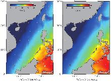
Fig. 1
Sea surface height data from SWOT in the research area"
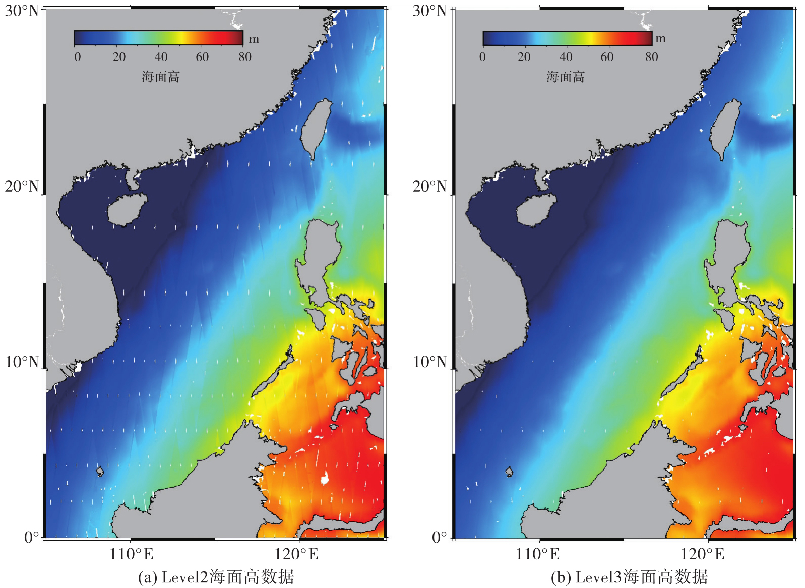
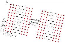
Fig. 2
2D SSH data from KaRIn in low resolution"
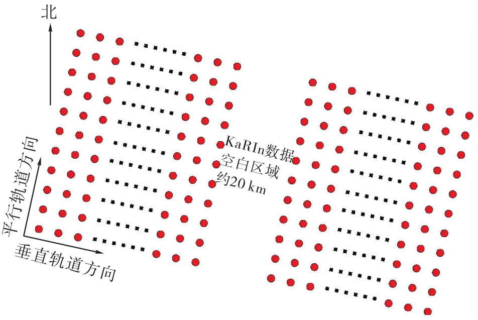

Fig. 3
Cross region for wide-swath data"
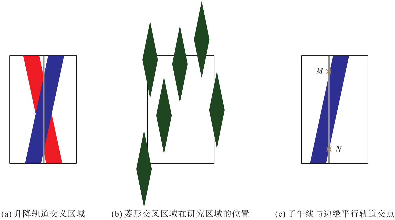
Fig. 4
The flowchart for calculating the position of crossoverpointpositionbytheimproved latitude difference methods"
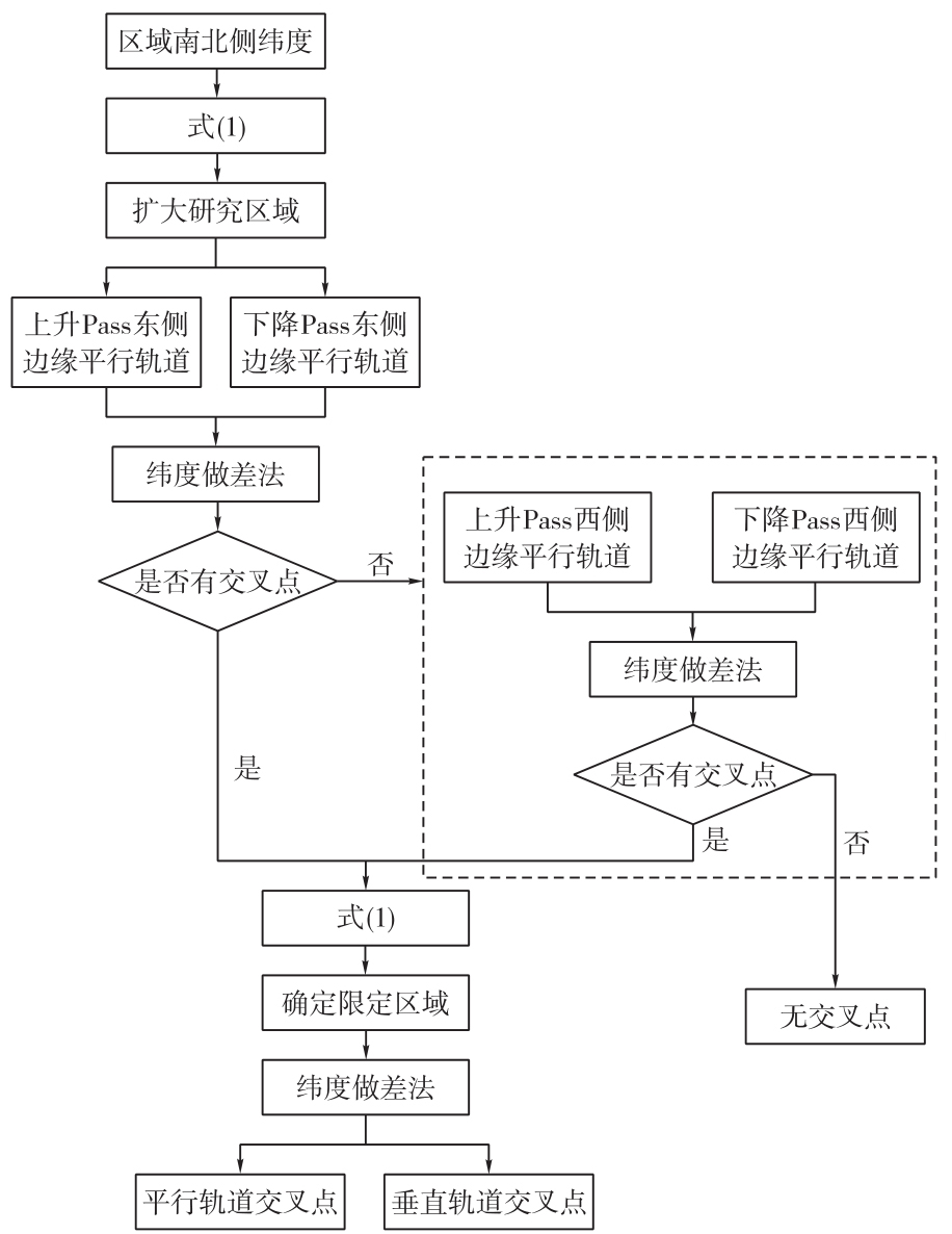
Fig. 5
Polynomial fitting results"
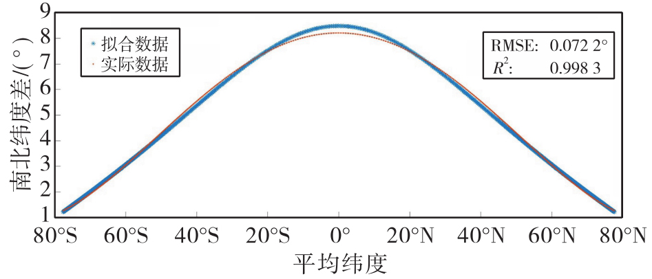
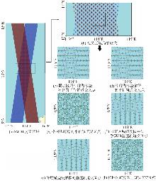
Fig. 6
Crossover points by different methods"

Tab. 1
The number of crossover points and time consumption calculated by different methods"
| 交叉点类型 | 方法 | 交叉点个数 | 时间/s | 参与计算点数 |
|---|---|---|---|---|
| 平行轨道交叉点 | 纬度做差法 | 632 260 | 12 988 | 2 885 293 196 |
| 基于限定区域的纬度做差法 | 632 260 | 2051 | 671 824 167 | |
| 格网法 | 1 640 474 | 1332 | — | |
| 垂直轨道交叉点 | 纬度做差法 | 613 596 | 5096 | 106 962 011 |
| 基于限定区域的纬度做差法 | 613 596 | 1060 | 99 019 219 | |
| 格网法 | 1 640 474 | 1332 | — |
Fig. 7
RMSE of SSH discrepancies at crossover points"
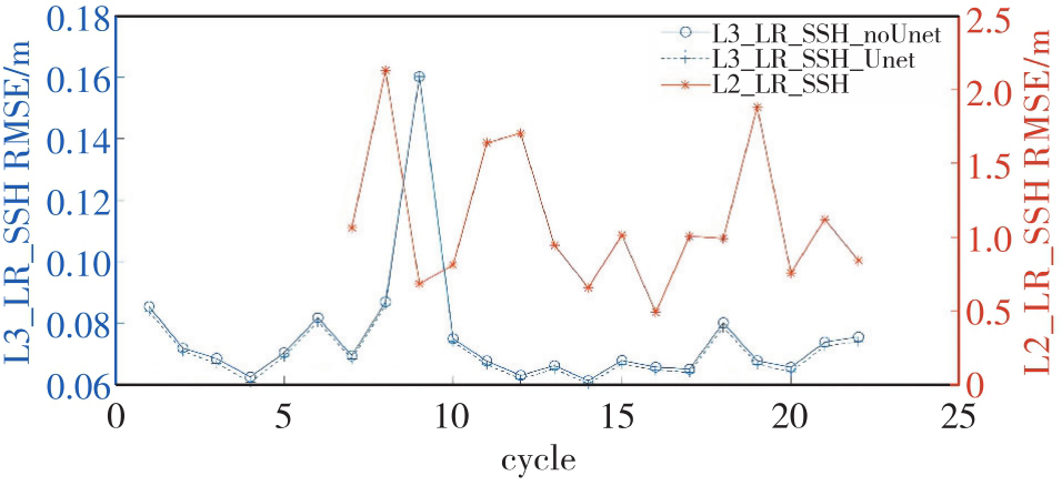
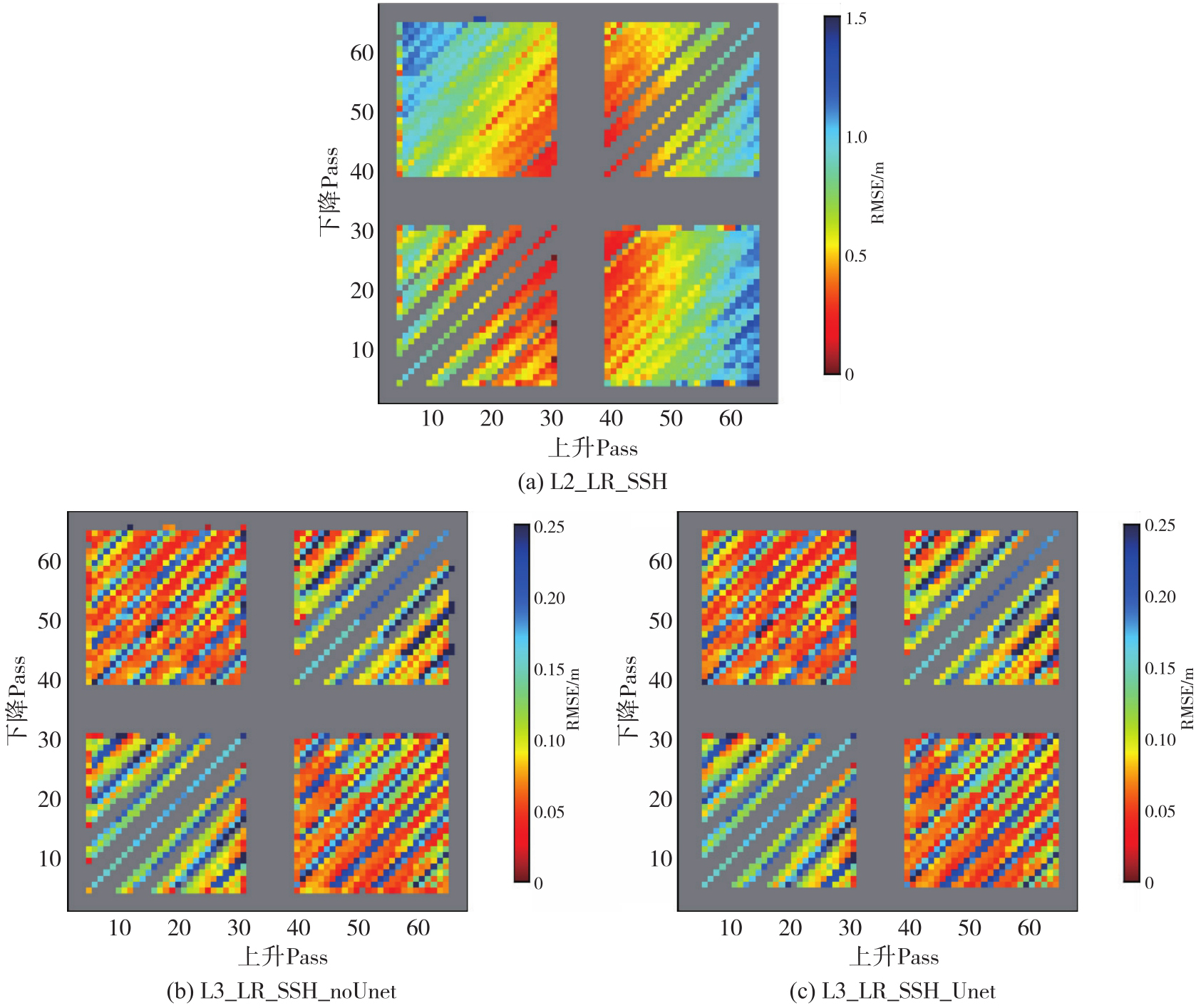
Fig. 8
RMSE of SSH discrepancies at crossover points between cross-track orbits in Cycle8"
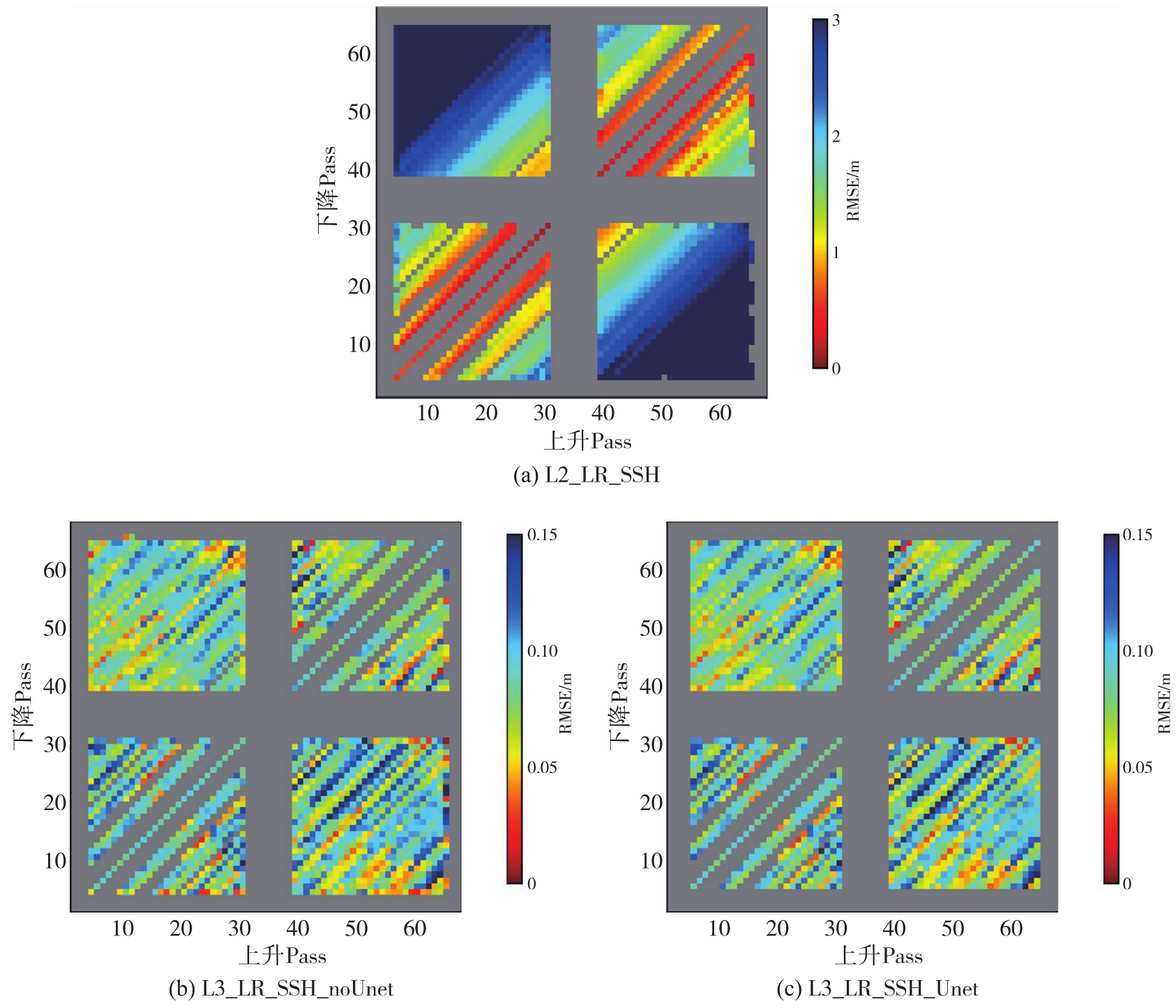

Fig. 9
RMSE of SSH discrepancies at crossover points between cross-track orbits in Cycle9"
| [1] | CHEN J L, WILSON C R, TAPLEY B D, et al. Long-term and seasonal Caspian Sea level change from satellite gravity and altimeter measurements[J]. Journal of Geophysical Research: Solid Earth, 2017, 122(3): 2274-2290. |
| [2] | FENG Jianlong, CHEN Qiaojun, LI Delei, et al. The dominant modes of recent sea level variability from 1993 to 2020 in the China Seas[J]. Global and Planetary Change, 2024, 237: 104451. |
| [3] | ANDERSEN O B, ZHANG S J, SANDWELL D T, et al. The unique role of the Jason geodetic missions for high resolution gravity field and mean sea surface modelling[J]. Remote Sensing, 2021, 13(4): 646. |
| [4] | SCHAEFFER P, PUJOL M I, VEILLARD P, et al. The CNES CLS 2022 mean sea surface: short wavelength improvements from CryoSat-2 and SARAL/AltiKa high-sampled altimeter data[J]. Remote Sensing, 2023, 15(11): 2910. |
| [5] | SMITH W H F. Resolution of seamount geoid anomalies achieved by the SARAL/AltiKa and Envisat RA2 satellite radar altimeters[J]. Marine Geodesy, 2015, 38(sup1): 644-671. |
| [6] | SUN Heping, BAO Lifeng, CHEN Shi, et al. Research progress in surface and marine gravimetry[J]. Journal of Geodesy and Geoinformation Science, 2023, 6(3): 19-32. |
| [7] | ZHU Chengcheng, GUO Jinyun, YUAN Jiajia, et al. SDUST2021GRA: global marine gravity anomaly model recovered from Ka-band and Ku-band satellite altimeter data[J]. Earth System Science Data, 2022, 14(10): 4589-4606. |
| [8] | ZINGERLE P, PAIL R, GRUBER T, et al. The combined global gravity field model XGM2019e[J]. Journal of Geodesy, 2020, 94(7): 66. |
| [9] |
李真, 郭金运, 孙中苗, 等. 基于ICESat-2多波束激光测高数据的全球海洋重力异常反演分析[J]. 测绘学报, 2024, 53(2): 252-262. DOI: .
doi: 10.11947/j.AGCS.2024.20230207 |
|
LI Zhen, GUO Jinyun, SUN Zhongmiao, et al. Global marine gravity anomalies recovered from multi-beam laser altimeter data of ICESat-2[J]. Acta Geodaetica et Cartographica Sinica, 2024, 53(2): 252-262. DOI: .
doi: 10.11947/j.AGCS.2024.20230207 |
|
| [10] | HWANG C, CHANG E T Y. Seafloor secrets revealed[J]. Science, 2014, 346(6205): 32-33. |
| [11] | TOZER B, SANDWELL D T, SMITH W H F, et al. Global bathymetry and topography at 15 arc sec: SRTM15+[J]. Earth and Space Science, 2019, 6(10): 1847-1864. |
| [12] | 金涛勇, 李建成, 姜卫平, 等. 基于多源卫星测高数据的新一代全球平均海面高模型[J]. 测绘学报, 2011, 40(6): 723-729. |
| JIN Taoyong, LI Jiancheng, JIANG Weiping, et al. The new generation of global mean sea surface height model based on multi-altimetric data[J]. Acta Geodaetica et Cartographica Sinica, 2011, 40(6): 723-729. | |
| [13] | 刘传勇, 暴景阳, 黄谟涛, 等. 验后平差方法在Geosat/GM卫星测高数据处理中的应用[J]. 海洋测绘, 2008, 28(1): 5-8. |
| LIU Chuanyong, BAO Jingyang, HUANG Motao, et al. The application of posteriori compensation theory of error in altimeter data set from geosat/GM crossover adjustment[J]. Hydrographic Surveying and Charting, 2008, 28(1): 5-8. | |
| [14] | DETTMERING D, BOSCH W. Global calibration of Jason-2 by multi-mission crossover analysis[J]. Marine Geodesy, 2010, 33: 150-161. |
| [15] | FU L, UBELMANN C. On the transition from profile altimeter to swath altimeter for observing global ocean surface topography. Journal of Atmospheric and Oceanic Technology, 2014, 31(2): 560-568. |
| [16] |
陈晓东, 杨萌, 袁园, 等. 中国近海SWOT_02重力场模型精度与空间分辨率评估[J]. 测绘学报, 2025, 54(6): 1031-1041. DOI: .
doi: 10.11947/j.AGCS.2025.20240487 |
|
CHEN Xiaodong, YANG Meng, YUAN Yuan, et al. Evaluation of the accuracy and spatial resolution of SWOT_02marine gravity model inChina'soffshoreregions[J]. ActaGeodaeticaetCartographicaSinica, 2025, 54(6): 1031-1041. DOI: .
doi: 10.11947/j.AGCS.2025.20240487 |
|
| [17] | HWANG C, YU Daocheng. Transforming coastal mapping from space[J]. Science, 2024, 386(6727): 1222-1223. |
| [18] |
押少帅, 刘新, 周瑞宸, 等. 基于科学阶段SWOT/KaRIn测高数据反演高精度的垂直重力异常梯度模型[J]. 测绘学报, 2025, 54(9): 1583-1595. DOI: .
doi: 10.11947/j.AGCS.2025.20240520 |
|
YA Shaoshuai, LIU Xin, ZHOU Ruichen, et al. High accuracy vertical gradient of gravity anomaly model determined from SWOT/KaRIn altimetry data during scientific phase[J]. Acta Geodaetica et Cartographica Sinica, 2025, 54(9): 1583-1595. DOI: .
doi: 10.11947/j.AGCS.2025.20240520 |
|
| [19] | 李杨, 周江存, 祝程程, 等. 基于模拟数据评估SWOT卫星KaRIn数据的测量误差对反演海洋重力场的影响[J]. 地球物理学报, 2024, 67(11): 4053-4064. |
| LI Yang, ZHOU Jiangcun, ZHU Chengcheng, et al. Assessing the impacts of measurement errors in SWOT satellite KaRIn data on the inversion of marine gravity based on simulated data[J]. Chinese Journal of Geophysics, 2024, 67(11): 4053-4064. | |
| [20] | MORROW R, FU L L, ARDHUIN F, et al. Global observations of fine-scale ocean surface topography with the surface water and ocean topography (SWOT) mission[J]. Frontiers in Marine Science, 2019, 6: 232. |
| [21] | WANG Jinbo, FU L L, TORRES H S, et al. On the spatial scales to be resolved by the surface water and ocean topography ka-band radar interferometer[J]. Journal of Atmospheric and Oceanic Technology, 2019, 36(1): 87-99. |
| [22] | DIBARBOURE G, LABROUE S, ABLAIN M, et al. Empirical cross-calibration of coherent SWOT errors using external references and the altimetry constellation[J]. IEEE Transactions on Geoscience and Remote Sensing, 2012, 50(6): 2325-2344. |
| [23] | LI Xiao, ZHANG Shengkai, GENG Tong, et al. An improved algorithm for extracting crossovers of satellite ground tracks[J]. Computers & Geosciences, 2022, 166: 105179. |
| [24] | 周晓光, 苗洪利, 王云海, 等. 卫星地面轨迹分段拟合确定交叉点的方法研究[J]. 测绘学报, 2012, 41(6): 811-815. |
| ZHOU Xiaoguang, MIAO Hongli, WANG Yunhai, et al. Study on the determination of crossovers by piecewise fitting of satellite ground track[J]. Acta Geodaetica et Cartographica Sinica, 2012, 41(6): 811-815. | |
| [25] | YUAN Jiajia, GUO Jinyun, NIU Yupeng, et al. Mean sea surface model over the sea of Japan determined from multi-satellite altimeter data and tide gauge records[J]. Remote Sensing, 2020, 12(24): 4168. |
| [26] | 魏巧云. 交叉点位置确定方法研究及相关数据处理[D]. 开封: 河南大学, 2017. |
| WEI Qiaoyun. Research on crossover points location determination method and related data processing[D]. Kaifeng: Henan University, 2017. | |
| [27] | SIBUET J C, YEH Y C, LEE C S. Geodynamics of the South China Sea[J]. Tectonophysics, 2016, 692: 98-119. |
| [28] | ZHU Chengcheng, GUO Jinyun, YA Shaoshuai, et al. Moving geoid gradient method for high-precision and high-resolution gravity recovery from SWOT wide-swath data[J]. IEEE Transactions on Geoscience and Remote Sensing, 2025, 63: 4205613. |
| [29] | SWOT project. SWOT Level-2 KaRIn Low Rate SSH Expert (v2.0)[DB/OL]. CNES(2023) [2025-06-27]. https://doi.org/10.24400/527896/a01-2023.015. |
| [30] | AVISO/DUACS. SWOT Level-3 KaRIn Low Rate SSH Expert (v2.0.1)[DB/OL]. CNES(2024) [2025-06-27]. https://doi.org/10.24400/527896/a01-2023.018. |
| [31] | 李真. 融合不同观测模式卫星测高数据的全球海洋垂线偏差和重力异常模型的构建[D]. 青岛: 山东科技大学, 2025. |
| LI Zhen. Global marine deflections of the vertical and gravity anomaly modeled by fusing altimeter data with multiple operating modes[D]. Qingdao: Shandong University of Science and Technology, 2025. | |
| [32] | TRÉBOUTTE A, CARLI E, BALLAROTTA M, et al. KaRIn noise reduction using a convolutional neural network for the SWOT ocean products[J]. Remote Sensing, 2023, 15: 2183. |
| [33] | YU Daocheng, HWANG C. Optimized processing of SWOT fast-sampling data for marine gravity recovery: lessons for the 21-day science phase[J]. Remote Sensing of Environment, 2025, 328: 114903. |
| [1] | Yi GAO, Xin LIU, Daocheng YU, Shaoshuai YA, Shaofeng BIAN, Heping SUN, Jinyun GUO. An automated seamount detection method integrating vertical gravity gradient anomaly and seafloor topographic models [J]. Acta Geodaetica et Cartographica Sinica, 2026, 55(4): 647-657. |
| [2] | Zhong LU, Jinqi ZHAO, Yufen NIU, Liquan CHEN, Qianyou FAN, Jinzhao SI, Zixuan WANG, Yuan GAO, Shuai WANG, Feifei QU, Hongtao SHI, Shiyong YAN, Yun SHI, Zheng ZHAO. The NISAR mission: innovations in earth observation and applications in surface deformation monitoring [J]. Acta Geodaetica et Cartographica Sinica, 2026, 55(2): 261-274. |
| [3] | Shaoshuai YA, Xin LIU, Ruichen ZHOU, Zhen LI, Shaofeng BIAN, Jinyun GUO. High accuracy vertical gradient of gravity anomaly model determined from SWOT/KaRIn altimetry data during scientific phase [J]. Acta Geodaetica et Cartographica Sinica, 2025, 54(9): 1583-1595. |
| [4] | Xiaodong CHEN, Meng YANG, Yuan YUAN, Wei FENG, Jinway HWANG, Min ZHONG. Evaluation of the accuracy and spatial resolution of SWOT_02 marine gravity model in China's offshore regions [J]. Acta Geodaetica et Cartographica Sinica, 2025, 54(6): 1031-1041. |
| [5] | Zhenhe ZHAI, Zhongmiao SUN, Jian MA, Bin GUAN, He HUANG, Mingda OUYANG, Lingyong HUANG, Zhiyong HUANG, Xingchen PAN, Shigeng YUAN, Shengli LIU, Sen LIU. Gravity field inversion from China ocean altimetry tandem satellites data and performance analysis [J]. Acta Geodaetica et Cartographica Sinica, 2025, 54(4): 714-724. |
| [6] | Xiaoran HAN, Yinghai KE, Jinyuan YU, Mengjie ZHAO, Guoqing ZHANG. Accuracy assessment of lake level and area measurement in the Qinghai-Tibet Plateau using simulated SWOT satellite data [J]. Acta Geodaetica et Cartographica Sinica, 2024, 53(5): 823-834. |
| [7] | LI Yang, ZHANG Running. Inference of Altimeter Accuracy on Along-track Gravity Anomaly Recovery [J]. Acta Geodaetica et Cartographica Sinica, 2015, 44(4): 363-369. |
| Viewed | ||||||
|
Full text |
|
|||||
|
Abstract |
|
|||||