

Acta Geodaetica et Cartographica Sinica ›› 2025, Vol. 54 ›› Issue (6): 1031-1041.doi: 10.11947/j.AGCS.2025.20240487
• Marine Survey • Previous Articles Next Articles
Xiaodong CHEN1,2( ), Meng YANG1,2,3, Yuan YUAN1,3, Wei FENG1,3, Jinway HWANG4, Min ZHONG1,3()
Received:2024-12-03
Revised:2025-05-09
Online:2025-07-14
Published:2025-07-14
Contact:
Min ZHONG
E-mail:chenxd97@mail2.sysu.edu.cn;zhongm63@sysu.edu.cn
About author:CHEN Xiaodong (1996—), male, PhD candidate, majors in altimeter data processing and bathymetric inversion using marine gravity data. E-mail: chenxd97@mail2.sysu.edu.cn
Supported by:CLC Number:
Xiaodong CHEN, Meng YANG, Yuan YUAN, Wei FENG, Jinway HWANG, Min ZHONG. Evaluation of the accuracy and spatial resolution of SWOT_02 marine gravity model in China's offshore regions[J]. Acta Geodaetica et Cartographica Sinica, 2025, 54(6): 1031-1041.
Tab. 1
Statistical information on global marine gravity anomaly models"
| 模型 | 发布年份 | 参考重力场 | 主要卫星测高数据来源 | 覆盖范围 | 开放链接 |
|---|---|---|---|---|---|
| SWOT_02 | 2024 | V32.1 | SWOT+T/P+J1+E2+En+J2+C2+Al+S3A+S3B | 80°S—80°N | |
| DTU21 | 2021 | EGM2008 | T/P+GFO+E2+J1+C2+J2+Al+S3A+S3B+I1 | 90°S—90°N | |
| V32.1 | 2022 | EGM2008 | T/P+J1+E2+En+J2+C2+Al+S3A+S3B | 80°S—80°N | |
| NSOAS24 | 2024 | EGM2008 | T/P+Ge+E1+J1+En+J2+J3+C2+Al+HY-2A+HY-2B | 80°S—80°N | |
| SDUST22 | 2024 | XGM2019e | T/P+E1+GFO+E2+J1+J2+En+J3+HY-2A+HY-2B+C2+Al+S3A+S3B+S6A+I2 | 80°S—82°N |
Tab. 2
Accuracy assessment of JAMSTEC shipborne data compared with marine gravity anomaly models"
| 模型 | 最大值 | 最小值 | 平均值 | RMS | STD |
|---|---|---|---|---|---|
| SWOT_02 | 29.40 | -25.81 | 0.71 | 3.96 | 3.90 |
| DTU21 | 11.45 | -11.45 | 0.28 | 4.06 | 4.05 |
| V32.1 | 41.52 | -43.14 | 0.54 | 5.25 | 5.22 |
| NSOAS24 | 24.75 | -38.14 | 0.88 | 4.84 | 4.76 |
| SDUST22 | 18.94 | -20.27 | 0.24 | 4.14 | 4.13 |
Tab. 3
Accuracy assessment of marine gravity anomaly models in Taiwan island coastal areas"
| 模型 | 最大值 | 最小值 | 平均值 | RMS | STD |
|---|---|---|---|---|---|
| SWOT_02 | 48.88 | -43.80 | 0.42 | 5.85 | 5.83 |
| DTU21 | 45.54 | -39.30 | 0.05 | 5.03 | 5.03 |
| V32.1 | 40.58 | -40.69 | 1.03 | 6.37 | 6.29 |
| NSOAS24 | 43.03 | -47.03 | 0.78 | 6.06 | 6.01 |
| SDUST22 | 42.81 | -39.27 | -0.18 | 5.88 | 5.88 |
Tab. 4
Accuracy assessment of NCEI shipborne data compared with marine gravity anomaly models"
| 模型 | 最大值 | 最小值 | 平均值 | RMS | STD |
|---|---|---|---|---|---|
| SWOT_02 | 28.70 | -27.87 | 1.87 | 5.84 | 5.53 |
| DTU21 | 18.98 | -18.98 | 1.88 | 6.03 | 5.73 |
| V32.1 | 35.77 | -47.87 | 1.94 | 6.40 | 6.10 |
| NSOAS24 | 33.19 | -38.76 | 1.84 | 6.14 | 5.86 |
| SDUST22 | 28.38 | -28.75 | 1.58 | 5.91 | 5.70 |
Tab. 5
Accuracy assessment of marine gravity field models using shipborne gravity data from two survey segments by Sun Yat-sen University"
| 模型 | “中山大学”号 | “中山大学极地”号 | ||
|---|---|---|---|---|
| STD/mGal | 相关系数 | STD/mGal | 相关系数 | |
| SWOT_02 | 1.21 | 0.996 | 4.23 | 0.935 |
| DTU21 | 2.42 | 0.984 | 2.66 | 0.971 |
| V32.1 | 2.41 | 0.985 | 4.06 | 0.938 |
| NSOAS24 | 2.84 | 0.979 | 1.83 | 0.986 |
| SDUST22 | 2.81 | 0.979 | 2.66 | 0.970 |

Fig. 1
Spatial distribution of gravity anomalies for different models in the test area"

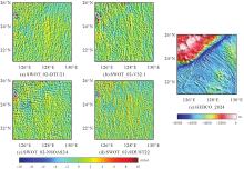
Fig. 2
Spatial distribution of gravity anomaly differences between the SWOT_02 model and other models, and seafloor topography in the test area"


Fig. 3
Spectral characteristics and coherence analysis of gravity anomaly models in the test area"


Fig. 4
Spectral and coherence analysis between shipborne gravity data and gravity anomaly models"

Tab. 6
Accuracy assessment of marine gravity field models compared with JAMSTEC shipborne data in shallow waters (0~500 m)"
| 模型 | 最大值 | 最小值 | 平均值 | RMS | STD |
|---|---|---|---|---|---|
| SWOT_02 | 29.40 | -25.61 | 0.21 | 5.10 | 5.09 |
| DTU21 | 11.45 | -11.45 | -0.68 | 4.79 | 4.74 |
| V32.1 | 41.52 | -43.14 | -0.58 | 9.39 | 9.37 |
| NSOAS24 | 24.75 | -36.63 | -1.09 | 6.34 | 6.24 |
| SDUST22 | 18.94 | -19.22 | -0.33 | 4.96 | 4.95 |
Tab. 7
Accuracy assessment of marine gravity field models compared with NCEI shipborne data in shallow waters (0~500 m)"
| 模型 | 最大值 | 最小值 | 平均值 | RMS | STD |
|---|---|---|---|---|---|
| SWOT_02 | 25.12 | -27.87 | 1.67 | 5.26 | 4.99 |
| DTU21 | 18.98 | -18.98 | 2.28 | 6.02 | 5.57 |
| V32.1 | 33.86 | -47.87 | 1.80 | 6.55 | 6.29 |
| NSOAS24 | 33.19 | -38.76 | 1.20 | 5.28 | 5.14 |
| SDUST22 | 25.22 | -25.55 | 1.12 | 5.10 | 4.98 |
Tab. 8
Accuracy evaluation of marine gravity field models relative to JAMSTEC shipborne data within 0~5 km from the coastline"
| 模型 | 最大值 | 最小值 | 平均值 | RMS | STD |
|---|---|---|---|---|---|
| SWOT_02 | 29.40 | -25.81 | 2.64 | 7.90 | 7.45 |
| DTU21 | 11.45 | -11.45 | 0.28 | 5.26 | 5.26 |
| V32.1 | 41.52 | -41.38 | 2.55 | 13.67 | 13.43 |
| NSOAS24 | 24.75 | -38.14 | -2.34 | 8.07 | 7.72 |
| SDUST22 | 18.14 | -20.27 | 0.57 | 5.70 | 5.67 |
Tab. 9
Accuracy evaluation of marine gravity field models relative to NCEI shipborne data within 0~5 km from the coastline"
| 模型 | 最大值 | 最小值 | 平均值 | RMS | STD |
|---|---|---|---|---|---|
| SWOT_02 | 25.12 | -22.11 | 6.71 | 8.65 | 5.46 |
| DTU21 | 18.94 | -18.90 | 7.65 | 10.19 | 6.74 |
| V32.1 | 33.86 | -33.38 | 8.39 | 11.46 | 7.80 |
| NSOAS24 | 33.19 | -25.35 | 3.18 | 6.18 | 5.29 |
| SDUST22 | 20.36 | -24.72 | 0.78 | 5.49 | 5.44 |
| [1] | SUN Heping, BAO Lifeng, CHEN Shi, et al. Research progress in surface and marine gravimetry[J]. Journal of Geodesy and Geoinformation Science, 2023, 6(3): 19-32. |
| [2] | ZINGERLE P, PAIL R, GRUBER T, et al. The combined global gravity field model XGM2019e[J]. Journal of Geodesy, 2020, 94(7): 66. |
| [3] | CARL B. The Earth's gravity field and plate tectonics[J]. Tectonophysics, 1991, 187(1/2/3): 69-89. |
| [4] | SANDWELL D T, MÜLLER R D, SMITH W H F, et al. New global marine gravity model from CryoSat-2 and Jason-1 reveals buried tectonic structure[J]. Science, 2014, 346(6205): 65-67. |
| [5] | HWANG C, CHANG E T Y. Seafloor secrets revealed[J]. Science, 2014, 346(6205): 32-33. |
| [6] | HWANG C, HSIAO Y S, SHIH H C, et al. Geodetic and geophysical results from a Taiwan airborne gravity survey: data reduction and accuracy assessment[J]. Journal of Geophysical Research: Solid Earth, 2007, 112(B4): 57. |
| [7] |
李真, 郭金运, 孙中苗, 等. 基于ICESat-2多波束激光测高数据的全球海洋重力异常反演分析[J]. 测绘学报, 2024, 53(2): 252-262. DOI: .
doi: 10.11947/j.AGCS.2024.20230207 |
|
LI Zhen, GUO Jinyun, SUN Zhongmiao, et al. Global marine gravity anomalies recovered from multi-beam laser altimeter data of ICESat-2[J]. Acta Geodaetica et Cartographica Sinica, 2024, 53(2): 252-262. DOI: .
doi: 10.11947/j.AGCS.2024.20230207 |
|
| [8] | YU Y, SANDWELL D T, DIBARBOURE G, et al. Accuracy and resolution of SWOT altimetry: foundation seamounts[J]. Earth and Space Science, 2024, 11(6): e2024EA003581. |
| [9] | GUO Jinyun, LUO Hongxin, ZHU Chengcheng, et al. Accuracy comparison of marine gravity derived from HY-2A/GM and CryoSat-2 altimetry data: a case study in the Gulf of Mexico[J]. Geophysical Journal International, 2022, 230(2): 1267-1279. |
| [10] | ABDALLA S, ABDEH KOLAHCHI A, ABLAIN M, et al. Altimetry for the future: building on 25 years of progress[J]. Advances in Space Research, 2021, 68(2): 319-363. |
| [11] | LI Zhen, GUO Jinyun, JI Bing, et al. A review of marine gravity field recovery from satellite altimetry[J]. Remote Sensing, 2022, 14(19): 4790. |
| [12] |
孙中苗, 管斌, 翟振和, 等. 海洋卫星测高及其反演全球海洋重力场和海底地形模型研究进展[J]. 测绘学报, 2022, 51(6): 923-934. DOI: .
doi: 10.11947/j.AGCS.2022.20220069 |
|
SUN Zhongmiao, GUAN Bin, ZHAI Zhenhe, et al. Research progress of ocean satellite altimetry and its recovery of global marine gravity field and seafloor topography model[J]. Acta Geodaetica et Cartographica Sinica, 2022, 51(6): 923-934. DOI: .
doi: 10.11947/j.AGCS.2022.20220069 |
|
| [13] | SANDWELL D T, GARCIA E, SOOFI K, et al. Toward 1-mGal accuracy in global marine gravity from CryoSat-2, Envisat, and Jason-1[J]. 2013, 32(8): 892-899. |
| [14] | VIGNUDELLI S, BIROL F, BENVENISTE J, et al. Satellite altimetry measurements of sea level in the coastal zone[J]. Surveys in Geophysics, 2019, 40(6): 1319-1349. |
| [15] | FAN Xin, GUO Jinyun, ZHANG Huiying, et al. A two-step method of crossover adjustment for satellite altimeter data[J]. Advances in Space Research, 2025, 75(1): 219-232. |
| [16] | ZAKI A, MANSI A H, SELIM M, et al. Comparison of satellite altimetric gravity and global geopotential models with shipborne gravity in the Red Sea[J]. Marine Geodesy, 2018, 41(3): 258-269. |
| [17] | ABDALLAH M, ABD EL GHANY R, RABAH M, et al. Comparison of recently released satellite altimetric gravity models with shipborne gravity over the Red Sea[J]. The Egyptian Journal of Remote Sensing and Space Science, 2022, 25(2): 579-592. |
| [18] | LI Qianqian, BAO Lifeng, WANG Yong. Accuracy evaluation of altimeter-derived gravity field models in offshore and coastal regions of China[J]. Frontiers in Earth Science, 2021, 9: 722019. |
| [19] | YU Daocheng, HWANG C, ANDERSEN O B, et al. Gravity recovery from SWOT altimetry using geoid height and geoid gradient[J]. Remote Sensing of Environment, 2021, 265: 112650. |
| [20] | SUN Mingzhi, FENG Wei, YU Daocheng, et al. Analysing the impact of SWOT observation errors on marine gravity recovery[J]. Geophysical Journal International, 2024, 237(2): 862-871. |
| [21] | WANG Jianbo, XU Yongsheng, ZHANG Qingjun, et al. Improving high-frequency marine gravity anomaly recovery: the efficacy of SWOT wide-swath altimetry[J]. IEEE Geoscience and Remote Sensing Letters, 2024, 21: 7505905. |
| [22] | YU Yao, SANDWELL D T, DIBARBOURE G. Abyssal marine tectonics from the SWOT mission[J]. Science, 2024, 386(6727): 1251-1256. |
| [23] | ANDERSEN O B, KNUDSEN P, BERRY P A M. The DNSC08GRA global marine gravity field from double retracked satellite altimetry[J]. Journal of Geodesy, 2010, 84(3): 191-199. |
| [24] | ZHANG Shengjun, ZHOU Runsheng, JIA Yongjun, et al. Performance of HaiYang-2 altimetric data in marine gravity research and a new global marine gravity model NSOAS22[J]. Remote Sensing, 2022, 14(17): 4322. |
| [25] | ZHANG Shengjun, CHEN Xu, ZHOU Runsheng, et al. NSOAS24: a new global marine gravity model derived from multi-satellite sea surface slopes[J]. Geoscientific Model Development, 2025, 18(4): 1221-1239. |
| [26] | ZHU Chengcheng, GUO Jinyun, YUAN Jiajia, et al. SDUST2021GRA: global marine gravity anomaly model recovered from Ka-band and Ku-band satellite altimeter data[J]. Earth System Science Data, 2022, 14(10): 4589-4606. |
| [27] | LI Zhen, GUO Jinyun, ZHU Chengcheng, et al. The SDUST2022GRA global marine gravity anomalies recovered from radar and laser altimeter data: contribution of ICESat-2 laser altimetry[J]. Earth System Science Data, 2024, 16(9): 4119-4135. |
| [28] | HUANG Motao, DENG Kailiang, WU Taiqi, et al. Research and evaluation on key technological indicators for airborne and shipborne gravimetry[J]. Journal of Geodesy and Geoinformation Science, 2019, 2(3): 44-54. |
| [29] | FAN Diao, LI Shanshan, MENG Shuyu, et al. Bathymetric prediction from multi-source satellite altimetry gravity data[J]. Journal of Geodesy and Geoinformation Science, 2019, 2(1): 49-58. |
| [30] | CHEN Xiaodong, ZHONG Min, SUN Mingzhi, et al. Recovering bathymetry using BP neural network combined with modified gravity-geologic method: a case study in the South China Sea[J]. Remote Sensing, 2024, 16(21): 4023. |
| [31] | LI Qianqian, ZHAI Zhenhe, BAO Lifeng, et al. A convolutional neural network to optimize multi-mission satellite altimeter fusion for improving the marine gravity field[J]. Earth, Planets and Space, 2024, 76(1): 129. |
| [32] | WELCH P. The use of fast Fourier transform for the estimation of power spectra: a method based on time averaging over short, modified periodograms[J]. IEEE Transactions on Audio and Electroacoustics, 1967, 15(2): 70-73. |
| [33] | WESSEL P, LUIS J F, UIEDA L, et al. The generic mapping tools version 6[J]. Geochemistry, Geophysics, Geosystems, 2019, 20(11): 5556-5564. |
| [34] | 李杨, 周江存, 祝程程, 等. 基于模拟数据评估SWOT卫星KaRIn数据的测量误差对反演海洋重力场的影响[J]. 地球物理学报, 2024, 67(11): 4053-4064. |
| LI Yang, ZHOU Jiangcun, ZHU Chengcheng, et al. Assessing the impacts of measurement errors in SWOT satellite KaRIn data on the inversion of marine gravity based on simulated data[J]. Chinese Journal of Geophysics, 2024, 67(11): 4053-4064. | |
| [35] | GUO Hengyang, WAN Xiaoyun, WANG Huaibing. Validation of just-released SWOT L2 KaRIn beta prevalidated data based on restore the marine gravity field and its application[J]. IEEE Journal of Selected Topics in Applied Earth Observations and Remote Sensing, 2024, 17: 7878-7887. |
| [36] | HWANG C, YU Daocheng. Transforming coastal mapping from space[J]. Science, 2024, 386(6727): 1222-1223. |
| [1] | Yi GAO, Xin LIU, Daocheng YU, Shaoshuai YA, Shaofeng BIAN, Heping SUN, Jinyun GUO. An automated seamount detection method integrating vertical gravity gradient anomaly and seafloor topographic models [J]. Acta Geodaetica et Cartographica Sinica, 2026, 55(4): 647-657. |
| [2] | Hao XU, Nan XU, Huichao XIN, Yue MA, Wei TU, Qingquan LI. A topographic photon extraction method for intertidal zones using ICESat-2 satellite altimeter data [J]. Acta Geodaetica et Cartographica Sinica, 2026, 55(4): 658-672. |
| [3] | Chengcheng ZHU, Zhen LI, Jinyun GUO, Maosheng ZHOU, Wanqiu LI. Improved latitude difference method for calculating crossover point position from wide-swath measurement data [J]. Acta Geodaetica et Cartographica Sinica, 2026, 55(4): 673-683. |
| [4] | Shaoshuai YA, Xin LIU, Ruichen ZHOU, Zhen LI, Shaofeng BIAN, Jinyun GUO. High accuracy vertical gradient of gravity anomaly model determined from SWOT/KaRIn altimetry data during scientific phase [J]. Acta Geodaetica et Cartographica Sinica, 2025, 54(9): 1583-1595. |
| [5] | Zhenhe ZHAI, Zhongmiao SUN, Jian MA, Bin GUAN, He HUANG, Mingda OUYANG, Lingyong HUANG, Zhiyong HUANG, Xingchen PAN, Shigeng YUAN, Shengli LIU, Sen LIU. Gravity field inversion from China ocean altimetry tandem satellites data and performance analysis [J]. Acta Geodaetica et Cartographica Sinica, 2025, 54(4): 714-724. |
| [6] | Xiaoran HAN, Yinghai KE, Jinyuan YU, Mengjie ZHAO, Guoqing ZHANG. Accuracy assessment of lake level and area measurement in the Qinghai-Tibet Plateau using simulated SWOT satellite data [J]. Acta Geodaetica et Cartographica Sinica, 2024, 53(5): 823-834. |
| [7] | SUN Zhongmiao, ZHAI Zhenhe, GUAN Bin, RUAN Rengui, HUANG Lingyong. Preliminary verification of dual-satellite tandem altimetry on board [J]. Acta Geodaetica et Cartographica Sinica, 2024, 53(2): 207-216. |
| [8] | GAO Xianwen, JIN Taoyong, LI Jiancheng. An improved retracker considering spatial and temporal characteristics of inland water level changes for SAR altimetry [J]. Acta Geodaetica et Cartographica Sinica, 2024, 53(2): 217-230. |
| [9] | LI Qianqian, BAO Lifeng, WANG Yong. Analysis of altimetry-derived sea surface observation anomalies for 2022 eruption of Tonga submarine volcano [J]. Acta Geodaetica et Cartographica Sinica, 2024, 53(2): 263-273. |
| [10] | LIU Huanling, YANG Weiran, ZHANG Fang, WEN Hanjiang, HU Minzhang, JIANG Tao, LIN Wenqi, LI Chenxi. Multi-scale analysis of gravity anomaly models in sea area [J]. Acta Geodaetica et Cartographica Sinica, 2024, 53(2): 274-285. |
| [11] | Xukang XIE, Wei LI. Water level extraction algorithm based on adaptive weighting and deviation matching of multi-source satellite altimetry data [J]. Acta Geodaetica et Cartographica Sinica, 2024, 53(11): 2111-2124. |
| [12] | ZHAO Chuang, JIN Taoyong, QIN Pengbo, YANG Lianjun. An improved multi-surface function method with residual constraint for the fusion of shipborne and satellite altimetry derived gravity data [J]. Acta Geodaetica et Cartographica Sinica, 2023, 52(4): 605-613. |
| [13] | FAN Diao, LI Shanshan, FENG Jinkai, HUANG Yan, FAN Haopeng, ZHANG Jinhui, LI Xinxing. Applying least square collocation method to predict seafloor topography in the unknown sea area [J]. Acta Geodaetica et Cartographica Sinica, 2023, 52(12): 2039-2053. |
| [14] | LI Yang, GUO Jinyun, SUN Yu, YUAN Jiajia, CHANG Xiaotao, ZHANG Hongri. Inversion of global sea level change and its component contributions by combining time-varying gravity data and altimetry data [J]. Acta Geodaetica et Cartographica Sinica, 2022, 51(8): 1768-1778. |
| [15] | XU Tianhe, MU Dapeng, YAN Haoming, GUO Jinyun, YIN Peng. The causes of contemporary sea level rise over recent two decades: progress and challenge [J]. Acta Geodaetica et Cartographica Sinica, 2022, 51(7): 1294-1305. |
| Viewed | ||||||
|
Full text |
|
|||||
|
Abstract |
|
|||||