


测绘学报 ›› 2024, Vol. 53 ›› Issue (4): 700-711.doi: 10.11947/j.AGCS.2024.20220389
李雪涛( ), 王盼成, 曾永年()
收稿日期:2022-06-17
修回日期:2024-01-04
发布日期:2024-05-13
通讯作者:
曾永年
E-mail:778978421@qq.com;ynzeng@csu.edu.cn
作者简介:李雪涛(1993—),男,硕士,主要研究方向为城市环境遥感与应用。E-mail:778978421@qq.com
基金资助:
Xuetao LI(), Pancheng WANG, Yongnian ZENG()
Received:2022-06-17
Revised:2024-01-04
Published:2024-05-13
Contact:
Yongnian ZENG
E-mail:778978421@qq.com;ynzeng@csu.edu.cn
About author:LI Xuetao (1993—), male, master, majors in remote sensing of urban environment and application. E-mail: 778978421@qq.com
Supported by:摘要:
城市非渗透表面信息的有效提取是高分辨率遥感应用研究的热点问题。针对目前城市非渗透表面信息提取中存在的问题,结合深度学习与集成学习的优势,提出了基于高分辨率遥感影像深度特征的城市非渗透表面集成学习方法。以高分二号多光谱数据为试验数据,以非渗透表面密集程度不同的城市区域为试验区,基于U-Net深度网络提取的高分辨率影像的深层次特征,采用Stacking机制的集成学习机提取城市非渗透表面信息。试验结果表明,基于深度特征的集成学习方法在城市非渗透表面信息提取中获得了较高的精度。在城市非渗透表面密集程度不同的试验区,总体精度不低于91.66%,Kappa系数不低于0.83;错分误差为7.83%~9.39%,漏分误差为7.22%~14.88%。相对于基于浅层光谱信息的集成学习、随机森林、支持向量机,总体精度、Kappa系数有显著提高,错分与漏分误差显著降低。说明深度特征信息能有效提高集成学习提取非渗透表面提取的用户精度与制图精度;相对于U-Net、SegNet深度学习网络,在稀疏、中等密集、密集、复杂4类非渗透表面试验区,有效提高了总体精度、Kappa系数,漏分、错分误差显著的减少。说明基于深度特征的集成学习能有效改善与提高非渗透表面提取的用户精度与制图精度。总体上,基于深度特征的高分辨率非渗透表面集成学习方法能获得较高的城市非渗透表面信息提取精度,在城市土地利用/覆盖分类中具有良好的应用前景。
中图分类号:
李雪涛, 王盼成, 曾永年. 基于高分辨率遥感影像深度特征的城市非渗透表面集成学习提取[J]. 测绘学报, 2024, 53(4): 700-711.
Xuetao LI, Pancheng WANG, Yongnian ZENG. Urban impervious surface extraction based on the deep features of high-resolution remote sensing image and ensemble learning[J]. Acta Geodaetica et Cartographica Sinica, 2024, 53(4): 700-711.
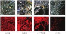
图1
试验区遥感影像及标签示例数据"
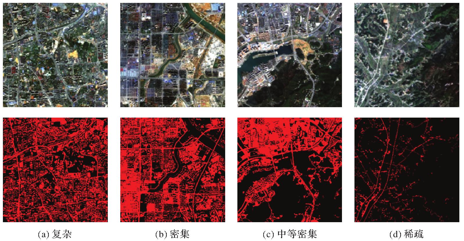
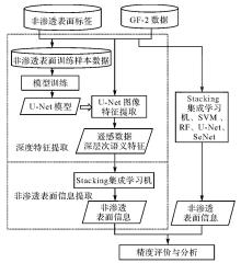
图2
基于深度特征的集成学习方法的城市非渗透表面信息提取方法"

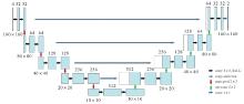
图3
本文研究的U-Net网络结构"
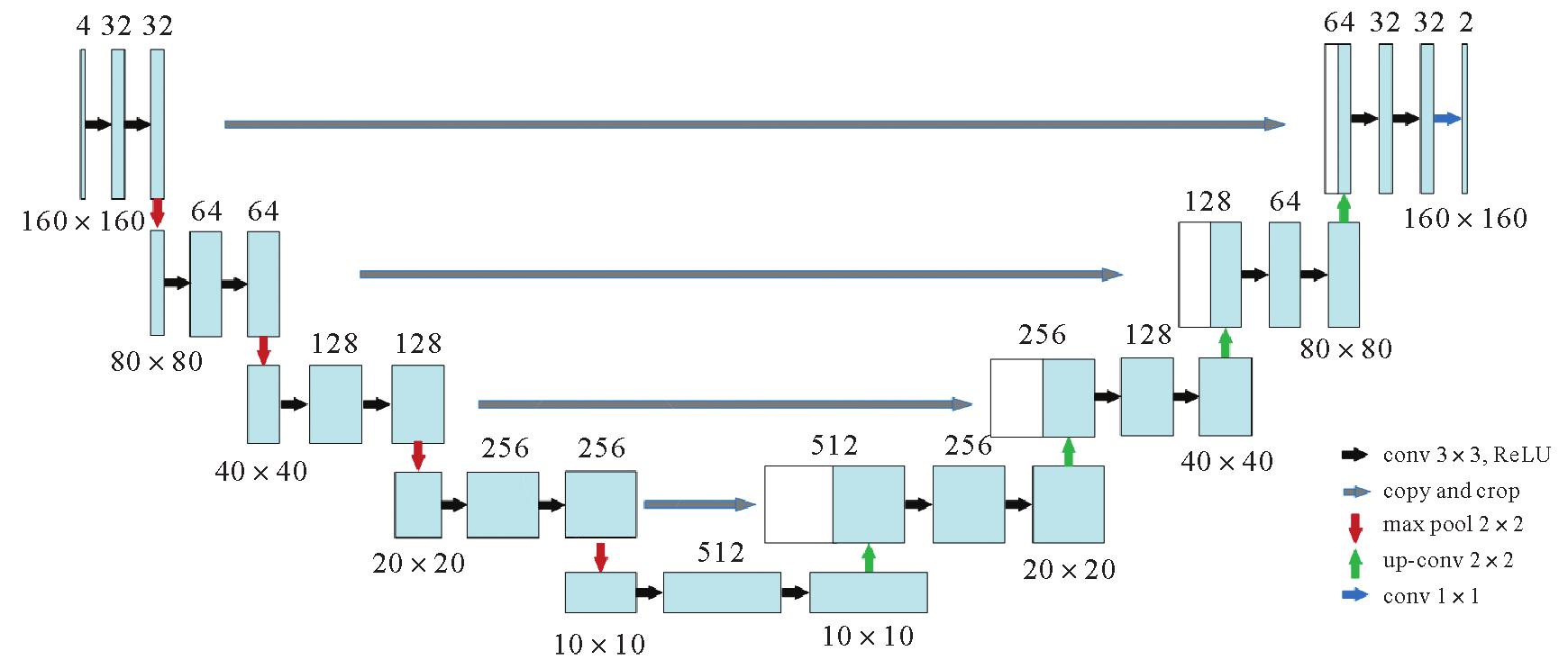
图4
训练和验证精度曲线"
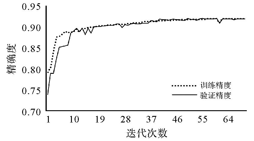
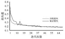
图5
训练和验证损失曲线"

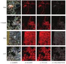
图6
基于深度特征的城市非渗透表面集成学习提取结果"

表1
城市非渗透表面提取精度评价结果"
| 密集程度 | ACC/(%) | P/(%) | R/(%) | F1值 | Kappa系数 |
|---|---|---|---|---|---|
| 稀疏 | 98.26 | 91.51 | 85.12 | 0.88 | 0.87 |
| 中等密集 | 97.29 | 92.17 | 88.16 | 0.90 | 0.89 |
| 密集 | 91.66 | 90.61 | 92.78 | 0.92 | 0.83 |
| 复杂 | 93.91 | 91.41 | 90.25 | 0.91 | 0.86 |
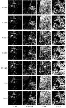
图7
本文方法与其他方法的结果对比"

表2
城市非渗透表面提取精度评价结果"
| 方法 | 密集程度 | ACC/(%) | P/(%) | R/(%) | F1值 | Kappa系数 |
|---|---|---|---|---|---|---|
| 本文方法 | 稀疏 | 98.26 | 91.51 | 85.12 | 0.88 | 0.87 |
| 中等密集 | 97.29 | 92.17 | 88.16 | 0.90 | 0.89 | |
| 密集 | 91.66 | 90.61 | 92.78 | 0.92 | 0.83 | |
| 复杂 | 93.91 | 91.41 | 90.25 | 0.91 | 0.86 | |
| 集成学习 | 稀疏 | 96.32 | 74.85 | 78.00 | 0.76 | 0.74 |
| 中等密集 | 92.41 | 68.98 | 83.20 | 0.76 | 0.71 | |
| 密集 | 78.92 | 93.09 | 62.06 | 0.78 | 0.58 | |
| 复杂 | 88.84 | 85.44 | 80.46 | 0.83 | 0.75 | |
| 随机森林 | 稀疏 | 62.51 | 97.10 | 75.86 | 0.69 | 0.66 |
| 中等密集 | 59.11 | 89.24 | 74.89 | 0.66 | 0.60 | |
| 密集 | 90.16 | 78.02 | 62.47 | 0.74 | 0.67 | |
| 复杂 | 73.15 | 85.92 | 91.72 | 0.81 | 0.70 | |
| 支持向量机 | 稀疏 | 67.31 | 95.66 | 83.89 | 0.75 | 0.72 |
| 中等密集 | 65.00 | 91.24 | 80.99 | 0.72 | 0.67 | |
| 密集 | 92.12 | 72.03 | 47.63 | 0.63 | 0.44 | |
| 复杂 | 67.86 | 83.30 | 95.40 | 0.79 | 0.66 | |
| U-Net | 稀疏 | 97.62 | 91.39 | 75.96 | 0.84 | 0.82 |
| 中等密集 | 95.74 | 90.99 | 77.23 | 0.844 | 0.81 | |
| 密集 | 89.85 | 89.75 | 87.32 | 0.90 | 0.80 | |
| 复杂 | 89.78 | 87.72 | 80.86 | 0.83 | 0.77 | |
| SegNet | 稀疏 | 92.74 | 71.11 | 81.02 | 0.76 | 0.72 |
| 中等密集 | 96.25 | 76.69 | 73.16 | 0.75 | 0.73 | |
| 密集 | 84.95 | 85.60 | 83.71 | 0.85 | 0.70 | |
| 复杂 | 88.53 | 85.47 | 79.30 | 0.82 | 0.74 |
| [1] | WENG Qihao. Remote sensing of impervious surfaces in the urban areas: requirements, methods, and trends[J]. Remote Sensing of Environment, 2012, 117:34-49. |
| [2] | 徐涵秋, 王美雅. 地表不透水面信息遥感的主要方法分析[J]. 遥感学报, 2016, 20(5):1270-1289. |
| XU Hanqiu, WANG Meiya. Remote sensing-based retrieval of ground impervious surfaces[J]. Journal of Remote Sensing, 2016, 20(5):1270-1289. | |
| [3] | YUAN Fei, BAUER M E. Comparison of impervious surface area and normalized difference vegetation index as indicators of surface urban heat island effects in Landsat imagery[J]. Remote Sensing of Environment, 2007, 106(3):375-386. |
| [4] | 曾永年, 张璎璎, 张鸿辉, 等. 城市扩展强度及其地表热特性遥感定量分析[J]. 测绘学报, 2010, 39(1):65-70,94. |
| ZENG Yongnian, ZHANG Yingying, ZHANG Honghui, et al. A quantitative analysis of urban growth and associated thermal characteristics using remote sensing data[J]. Acta Geodaetica et Cartographica Sinica, 2010, 39(1):65-70,94. | |
| [5] | YU Huafei, ZHAO Yaolong, FU Yingchun, et al. Spatiotemporal variance assessment of urban rainstorm waterlogging affected by impervious surface expansion: a case study of Guangzhou, China[J]. Sustainability, 2018, 10(10):3761. |
| [6] | 宫鹏, 黎夏, 徐冰. 高分辨率影像解译理论与应用方法中的一些研究问题[J]. 遥感学报, 2006, 10(1):1-5. |
| GONG Peng, LI Xia, XU Bing. Interpretation theory and application method development for information extraction from high resolution remotely sensed data[J]. Journal of Remote Sensing, 2006, 10(1):1-5. | |
| [7] | HU Xuefei, WENG Qihao. Impervious surface area extraction from IKONOS imagery using an object-based fuzzy method[J]. Geocarto International, 2011, 26(1):3-20. |
| [8] | 李德仁, 童庆禧, 李荣兴, 等. 高分辨率对地观测的若干前沿科学问题[J]. 中国科学:地球科学, 2012, 42(6):805-813. |
| LI Deren, TONG Qingxi, LI Rongxing, et al. Some frontier scientific problems of high-resolution earth observation[J]. Scientia Sinica (Terrae), 2012, 42(6):805-813. | |
| [9] | 张翰超, 宁晓刚, 王浩, 等. 基于高分辨率遥感影像的2000—2015年中国省会城市高精度扩张监测与分析[J]. 地理学报, 2018, 73(12):2345-2363. |
| ZHANG Hanchao, NING Xiaogang, WANG Hao, et al. High accuracy urban expansion monitoring and analysis of China's provincial capitals from 2000 to 2015 based on high-resolution remote sensing imagery[J]. Acta Geographica Sinica, 2018, 73(12):2345-2363. | |
| [10] | HUANG X, WANG Y, LI J, et al. High-resolution urban land-cover mapping and landscape analysis of the 42 major cities in China using ZY-3 satellite images[J]. Sci Bull (Beijing), 2020, 65(12):1039-1048. |
| [11] | NEYNS R, CANTERS F. Mapping of urban vegetation with high-resolution remote sensing: a review[J]. Remote Sensing, 2022, 14(4):1031. |
| [12] | BLASCHKE T, HAY G J, KELLY M, et al. Geographic object-based image analysis-towards a new paradigm[J]. ISPRS Journal of Photogrammetry and Remote Sensing, 2014, 87:180-191. |
| [13] | JOZDANI S E, JOHNSON B A, CHEN Dongmei. Comparing deep neural networks, ensemble classifiers, and support vector machine algorithms for object-based urban land use/land cover classification[J]. Remote Sensing, 2019, 11(14):1713. |
| [14] | JOHNSON B, XIE Zhixiao. Classifying a high resolution image of an urban area using super-object information[J]. ISPRS Journal of Photogrammetry and Remote Sensing, 2013, 83:40-49. |
| [15] | MYINT S W, GOBER P, BRAZEL A, et al. Per-pixel vs. object-based classification of urban land cover extraction using high spatial resolution imagery[J]. Remote Sensing of Environment, 2011, 115(5):1145-1161. |
| [16] | TREITZ P. High spatial resolution remote sensing data for forest ecosystem classification an examination of spatial scale[J]. Remote Sensing of Environment, 2000, 72(3):268-289. |
| [17] | WANG L, SOUSA W P, GONG P. Integration of object-based and pixel-based classification for mapping mangroves with IKONOS imagery[J]. International Journal of Remote Sensing, 2004, 25(24):5655-5668. |
| [18] | YU Qian, GONG Peng, CLINTON N, et al. Object-based detailed vegetation classification with airborne high spatial resolution remote sensing imagery[J]. Photogrammetric Engineering & Remote Sensing, 2006, 72(7):799-811. |
| [19] | HUANG Xin, ZHANG Liangpei. An adaptive mean-shift analysis approach for object extraction and classification from urban hyperspectral imagery[J]. IEEE Transactions on Geoscience and Remote Sensing, 2008, 46(12):4173-4185. |
| [20] | TRIAS-SANZ R, STAMON G, LOUCHET J. Using colour, texture, and hierarchial segmentation for high-resolution remote sensing[J]. ISPRS Journal of Photogrammetry and Remote Sensing, 2008, 63(2):156-168. |
| [21] | SU Wei, LI Jing, CHEN Yunhao, et al. Textural and local spatial statistics for the object-oriented classification of urban areas using high resolution imagery[J]. International Journal of Remote Sensing, 2008, 29(11):3105-3117. |
| [22] | MA Lei, LI Manchun, MA Xiaoxue, et al. A review of supervised object-based land-cover image classification[J]. ISPRS Journal of Photogrammetry and Remote Sensing, 2017, 130:277-293. |
| [23] | BELGIU M, DRAGUT L. Random forest in remote sensing: a review of applications and future directions[J]. ISPRS Journal of Photogrammetry and Remote Sensing, 2016, 114:24-31. |
| [24] | 杜培军, 阿里木·赛买提. 高分辨率遥感影像分类的多示例集成学习[J]. 遥感学报, 2013, 17(1):77-97. |
| DU Peijun, SAMAT Alim. Multiple instance ensemble learning method for high-resolution remote sensing image classification[J]. Journal of Remote Sensing, 2013, 17(1):77-97. | |
| [25] | MOUNTRAKIS G, IM J, OGOLE C. Support vector machines in remote sensing: a review[J]. ISPRS Journal of Photogrammetry and Remote Sensing, 2011, 66(3):247-259. |
| [26] | 周培诚, 程塨, 姚西文, 等. 高分辨率遥感影像解译中的机器学习范式[J]. 遥感学报, 2021, 25(1):182-197. |
| ZHOU Peicheng, CHENG Gong, YAO Xiwen, et al. Machine learning paradigms in high-resolution remote sensing image interpretation[J]. National Remote Sensing Bulletin, 2021, 25(1):182-197. | |
| [27] | YUAN Qiangqiang, SHEN Huanfeng, LI Tongwen, et al. Deep learning in environmental remote sensing: achievements and challenges[J]. Remote Sensing of Environment, 2020, 241:111716. |
| [28] | MA Lei, LIU Yu, ZHANG Xueliang, et al. Deep learning in remote sensing applications: a meta-analysis and review[J]. ISPRS Journal of Photogrammetry and Remote Sensing, 2019, 152:166-177. |
| [29] | HEYDARI S S, MOUNTRAKIS G. Meta-analysis of deep neural networks in remote sensing: a comparative study of mono-temporal classification to support vector machines[J]. ISPRS Journal of Photogrammetry and Remote Sensing, 2019, 152:192-210. |
| [30] | GUO Mingqiang, LIU Heng, XU Yongyang, et al. Building extraction based on U-net with an attention block and multiple losses[J]. Remote Sensing, 2020, 12(9):1400. |
| [31] | XU Yongyang, WU Liang, XIE Zhong, et al. Building extraction in very high resolution remote sensing imagery using deep learning and guided filters[J]. Remote Sensing, 2018, 10(1):144. |
| [32] | ALSHEHHI R, MARPU P R, WOON W L, et al. Simultaneous extraction of roads and buildings in remote sensing imagery with convolutional neural networks[J]. ISPRS Journal of Photogrammetry and Remote Sensing, 2017, 130:139-149. |
| [33] | LÜ Xianwei, MING Dongping, LU Tingting, et al. A new method for region-based majority voting CNNs for very high resolution image classification[J]. Remote Sensing, 2018, 10(12):1946. |
| [34] | 王斌, 陈占龙, 吴亮, 等. 兼顾连通性的U-Net网络高分辨率遥感影像道路提取[J]. 遥感学报, 2020, 24(12):1488-1499. |
| WANG Bin, CHEN Zhanlong, WU Liang, et al. Road extraction of high-resolution satellite remote sensing images in U-Net network with consideration of connectivity[J]. National Remote Sensing Bulletin, 2020, 24(12):1488-1499. | |
| [35] | FU Gang, LIU Changjun, ZHOU Rong, et al. Classification for high resolution remote sensing imagery using a fully convolutional network[J]. Remote Sensing, 2017, 9(5):498. |
| [36] | HU Yunfeng, ZHANG Qianli, ZHANG Yunzhi, et al. A deep convolution neural network method for land cover mapping: a case study of Qinhuangdao, China[J]. Remote Sensing, 2018, 10(12):2053. |
| [37] | 陈妮, 应丰, 王静, 等. 基于U-Net的高分辨率遥感图像土地利用信息提取[J]. 遥感技术与应用, 2021, 36(2):285-292. |
| CHEN Ni, YING Feng, WANG Jing, et al. Research on land use information extraction based on U-net[J]. Remote Sensing Technology and Application, 2021, 36(2):285-292. | |
| [38] | 徐知宇, 周艺, 王世新, 等. 面向GF-2遥感影像的U-Net城市绿地分类[J]. 中国图象图形学报, 2021, 26(3):700-713. |
| XU Zhiyu, ZHOU Yi, WANG Shixin, et al. U-Net for urban green space classification in Gaofen-2 remote sensing images[J]. Journal of Image and Graphics, 2021, 26(3):700-713. | |
| [39] | 蔡博文, 王树根, 王磊, 等. 基于深度学习模型的城市高分辨率遥感影像不透水面提取[J]. 地球信息科学学报, 2019, 21(9):1420-1429. |
| CAI Bowen, WANG Shugen, WANG Lei, et al. Extraction of urban impervious surface from high-resolution remote sensing imagery based on deep learning[J]. Journal of Geo-Information Science, 2019, 21(9):1420-1429. | |
| [40] | HUANG Fenghua, YU Ying, FENG Tinghao. Automatic extraction of impervious surfaces from high resolution remote sensing images based on deep learning[J].Journal of Visual Communication and Image Representation, 2019, 58:453-461. |
| [41] | FU Yongyong, LIU Kunkun, SHEN Zhangquan, et al. Mapping impervious surfaces in town-rural transition belts using China's GF-2 imagery and object-based deep CNNs[J]. Remote Sensing, 2019, 11(3):280. |
| [42] | 孙根云, 王鑫, 安娜, 等. 基于多源遥感的大尺度高分辨率不透水面深度学习提取方法[J]. 测绘学报, 2023, 52(2):272-282.DOI: 10.11947/j.AGCS.2023.20210546. |
| SUN Genyun, WANG Xin, AN Na, et al. A method for large-scale and high-resolution impervious surface extraction based on multi-source remote sensing and deep learning[J]. Acta Geodaetica et Cartographica Sinica, 2023, 52(2):272-282.DOI: 10.11947/j.AGCS.2023.20210546. | |
| [43] | CHANG Ruichun, HOU Dong, CHEN Zhe, et al. Automatic extraction of urban impervious surface based on SAH-unet[J]. Remote Sensing, 2023, 15(4):1042. |
| [44] | SHAO Zhenfeng, CHENG Tao, FU Huyan, et al. Emerging issues in mapping urban impervious surfaces using high-resolution remote sensing images[J]. Remote Sensing, 2023, 15(10):2562. |
| [45] | 冯权泷, 陈泊安, 李国庆, 等. 遥感影像样本数据集研究综述[J]. 遥感学报, 2022, 26(4):589-605. |
| FENG Quanlong, CHEN Boan, LI Guoqing, et al. A review for sample datasets of remote sensing imagery[J]. National Remote Sensing Bulletin, 2022, 26(4):589-605. | |
| [46] | CHENG Gong, LI Zhenpeng, HAN Junwei, et al. Exploring hierarchical convolutional features for hyperspectral image classification[J]. IEEE Transactions on Geoscience and Remote Sensing, 2018, 56(11):6712-6722. |
| [47] | 许夙晖, 慕晓冬, 赵鹏, 等. 利用多尺度特征与深度网络对遥感影像进行场景分类[J]. 测绘学报, 2016, 45(7):834-840.DOI: 10.11947/J.AGCS.2016.20150623. |
| XU Suhui, MU Xiaodong, ZHAO Peng, et al. Scene classification of remote sensing image based on multi-scale feature and deep neural network[J]. Acta Geodaetica et Cartographica Sinica, 2016, 45(7):834-840.DOI: 10.11947/J.AGCS.2016.20150623. | |
| [48] | 余东行, 张保明, 赵传, 等. 联合卷积神经网络与集成学习的遥感影像场景分类[J]. 遥感学报, 2020, 24(6):717-727. |
| YU Donghang, ZHANG Baoming, ZHAO Chuan, et al. Scene classification of remote sensing image using ensemble convolutional neural network[J]. Journal of Remote Sensing, 2020, 24(6):717-727. | |
| [49] | LI Ruirui, LIU Wenjie, YANG Lei, et al. DeepUNet: a deep fully convolutional network for pixel-level sea-land segmentation[J]. IEEE Journal of Selected Topics in Applied Earth Observations and Remote Sensing, 2018, 11(11):3954-3962. |
| [50] | XU W, DENG X, GUO S, et al. High-resolution U-net: preserving image details for cultivated land extraction[J]. Sensors (Basel), 2020, 20(15):E4064. |
| [51] | RONNEBERGER O, FISCHER P, BROX T. U-net: convolutional networks for biomedical image segmentation[C]//Proceedings of 2005 International Conference on Medical Image Computing and Computer-Assisted Intervention.Berlin: Springer, 2005: 234-241. |
| [1] | 王立增, 程诗奋, 杨一涛, 王培晓, 陆锋. 局部-全局联合感知的时空自适应交通集成预测方法[J]. 测绘学报, 2026, 55(2): 206-221. |
| [2] | 鄢薪, 慎利, 潘俊杰, 戴延帅, 王继成, 郑晓莉, 李志林. 多尺度特征融合与空间优化的弱监督高分遥感建筑变化检测[J]. 测绘学报, 2024, 53(8): 1586-1597. |
| [3] | 刘雅婷, 陈传法. 顾及空间异质性和特征优选的滑坡易发性评价方法[J]. 测绘学报, 2024, 53(7): 1417-1428. |
| [4] | 殷吉崇, 武芳, 翟仁健, 邱越, 巩现勇, 行瑞星. 面向建筑物轮廓规则化的双路径边界约束与相对论生成对抗网络[J]. 测绘学报, 2024, 53(7): 1444-1457. |
| [5] | 顾海燕, 杨懿, 李海涛, 孙立坚, 丁少鹏, 刘世琦. 高分辨率遥感影像样本库动态构建与智能解译应用[J]. 测绘学报, 2024, 53(6): 1165-1179. |
| [6] | 彭代锋, 翟晨晨, 周顶蔚, 张永军, 管海燕, 臧玉府. 基于金字塔语义token全局信息增强的高分光学遥感影像变化检测[J]. 测绘学报, 2024, 53(6): 1195-1211. |
| [7] | 王继成, 郭安嵋, 慎利, 蓝天, 徐柱, 李志林. 多级对比学习下的弱监督高分遥感影像城市固废堆场提取[J]. 测绘学报, 2024, 53(6): 1212-1223. |
| [8] | 姜三, 刘凯, 李清泉, 江万寿. 融合深度特征的无人机影像SfM重建[J]. 测绘学报, 2024, 53(2): 321-331. |
| [9] | 林云浩, 王艳军, 李少春, 蔡恒藩. 一种耦合DeepLab与Transformer的农作物种植类型遥感精细分类方法[J]. 测绘学报, 2024, 53(2): 353-366. |
| [10] | 胡明洪, 李佳田, 姚彦吉, 阿晓荟, 陆美, 李文. 结合多路径的高分辨率遥感影像建筑物提取SER-UNet算法[J]. 测绘学报, 2023, 52(5): 808-817. |
| [11] | 刘帅, 李笑迎, 于梦, 邢光龙. 高分辨率遥感图像双解耦语义分割网络模型[J]. 测绘学报, 2023, 52(4): 638-647. |
| [12] | 胡安娜, 刘睿, 吴亮, 张进, 徐永洋, 陈思琼. 顾及全局特征和纹理特征的遥感影像超分辨率重建方法[J]. 测绘学报, 2023, 52(4): 648-659. |
| [13] | 姜明, 张新长, 孙颖, 冯炜明, 阮永俭. 全尺度特征聚合的高分辨率遥感影像变化检测网络[J]. 测绘学报, 2023, 52(10): 1738-1748. |
| [14] | 张广斌, 高贤君, 冉树浩, 杨元维, 李丽珊, 张妍. 高分遥感影像云雪共存区轻量云高精度检测方法[J]. 测绘学报, 2023, 52(1): 93-107. |
| [15] | 何直蒙, 丁海勇, 安炳琪. 高分辨率遥感影像建筑物提取的空洞卷积E-Unet算法[J]. 测绘学报, 2022, 51(3): 457-467. |
| 阅读次数 | ||||||
|
全文 |
|
|||||
|
摘要 |
|
|||||