


测绘学报 ›› 2025, Vol. 54 ›› Issue (9): 1537-1560.doi: 10.11947/j.AGCS.2025.20250274
• 综述 • 下一篇
李建成1( ), 吴云龙2(), 姚宜斌3, 罗志才4
收稿日期:2025-07-08
修回日期:2025-09-15
出版日期:2025-10-10
发布日期:2025-10-10
通讯作者:
吴云龙
E-mail:jcli@whu.edu.cn;wuyunlong@cug.edu.cn
作者简介:李建成(1964—),男,教授,中国工程院院士,研究方向为卫星大地测量学和物理大地测量学。E-mail:jcli@whu.edu.cn
基金资助:
Jiancheng LI1(), Yunlong WU2(), Yibing YAO3, Zhicai LUO4
Received:2025-07-08
Revised:2025-09-15
Online:2025-10-10
Published:2025-10-10
Contact:
Yunlong WU
E-mail:jcli@whu.edu.cn;wuyunlong@cug.edu.cn
About author:LI Jiancheng (1964—), male, professor, academician of Chinese Academy of Engineering, majors in satellite geodesy and physical geodesy. E-mail: jcli@whu.edu.cn
Supported by:摘要:
卫星重力测量技术作为现代大地测量学的重要突破,凭借其对地球表层和浅层物质质量变化的整体响应能力,已广泛应用于大地测量、水文循环、冰川消融、海平面变化和构造变形等关键领域。本文系统梳理了自CHAMP、GRACE到GRACE-FO以及中国重力卫星的任务发展与技术演进,聚焦下一代重力卫星计划,以及国际在研的新型量子重力任务的前沿趋势。在此基础上,全面总结了卫星重力数据从Level-0到Level-3的处理流程、关键反演方法、科学产品构建,及其在陆地水文、冰川、海洋、地震和高程基准构建中的典型应用。梳理分享了我国卫星重力应用体系当前所面临的数据质量限制、多源信号分离难题、人工智能模型可解释性不足及学科融合障碍等主要挑战,提出未来应加强“数据-场景-模式”协同创新,推动多源卫星组网与高精度建模,服务国家战略需求和全球可持续发展。
中图分类号:
李建成, 吴云龙, 姚宜斌, 罗志才. 面向“数据-场景-模式”驱动的卫星重力技术研究进展、挑战与趋势[J]. 测绘学报, 2025, 54(9): 1537-1560.
Jiancheng LI, Yunlong WU, Yibing YAO, Zhicai LUO. Satellite gravity technology oriented towards data-scenario-model driven approach: developments, challenges and outlook[J]. Acta Geodaetica et Cartographica Sinica, 2025, 54(9): 1537-1560.

图1
重力卫星的发展注:时间精确到月份,根据实际发射和退役日期调整;未来任务仅显示年份。"

表1
GRACE科学产品"
| 数据处理级别 | 数据产品/工具名 | 平台名 | 发布源 |
|---|---|---|---|
| L3 | Land Water-Equivalent-Thickness/Ocean Bottom Pressure | PODAAC | |
| L3 | Mascon | PODAAC | |
| L4 | Antarctica/Greenland/Ocean Mass Anomaly | PODAAC | |
| L4 | GRACE(-FO)Data Analysis Tool | JPL | |
| L3 | Mascon | CSR | |
| L3 | Mascon | GSFC | |
| L4 | Trend | GSFC | |
| L4 | Mascon Visualization Tool | CCAR | |
| L4 | 3D Visualisation | ICGEM | |
| L3/L4 | Terrestrial Water Storage/Groundwater Storage/Ocean Bottom Pressure | GravIS | |
| L4 | The COST-G Plotter | COST-G |
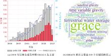
图2
2000年以来全球及中国GRACE发文量及前200个关键词的词云(注:在Web of Science上以GRACE/GRACE-FO和Satellite为关键字检索)"


图3
GRACE 1天到1个月时间间隔星下点轨迹的空间覆盖[166]"


图4
GRACE重力卫星与其主要探测目标,包括海水质量变化、冰川变化、水储量变化和固体地球如大地震的变化[179]"

表2
相关学科对地球重力场反演精度需求[181]"
| 应用领域 | 大地水准面/cm | 重力异常/mGal | 空间分辨率(半波长)/km | |
|---|---|---|---|---|
| 大地测量学 | GPS水准 | ~1 | 100~1000 | |
| 统一高程水准 | <5 | 50~100 | ||
| 惯性导航系统 | 1~5 | 100~1000 | ||
| 精密定轨 | 1~3 | 100~1000 | ||
| 固体地球物理学 | 地质构造移动 | 1~2 | 100~500 | |
| 地震灾害 | ~1 | 100~1000 | ||
| 海洋学 | 小尺度 | 1~2 | 60~250 | |
| 洋盆尺度 | <1 | 1000 | ||
| 冰川学 | 冰川的垂直运动 | ~2 | 1~5 | 50~200 |
| 水资源学 | 地表水/地下水 | 0.5~1 | 100~500 | |
| [1] | BAKER R M L. Orbit determination from range and range rate data[C]//Proceedings of 1960 Semi-Annual Meeting of the American Rocket Society. Los Angeles: ARS Preprint. 1960: 1220-1260. |
| [2] | WOLFF M. Direct measurements of the Earth's gravitational potential using a satellite pair[J]. Journal of Geophysical Research (1896—1977), 1969, 74(22): 5295-300. |
| [3] | EL-BAZ F, WARNER D M. Apollo-Soyuz test project: astronomy, Earth atmosphere and gravity field, life sciences, and materials processing[R]. [S.l.]: Scientific and Technical Information Office, National Aeronautics and Space Administration, 1977. |
| [4] | REIGBER C, LÜHR H, SCHWINTZER P. CHAMP mission status[J]. Advances in Space Research, 2002, 30(2): 129-134. |
| [5] | FLOBERGHAGEN R, FEHRINGER M, LAMARRE D, et al. Mission design, operation and exploitation of the gravity field and steady-state ocean circulation explorer mission[J]. Journal of Geodesy, 2011, 85(11): 749-758. |
| [6] | 罗子人, 张敏, 靳刚, 等. 中国空间引力波探测“太极计划”及“太极1号”在轨测试[J]. 深空探测学报, 2020, 7(1): 3-10. |
| LUO Ziren, ZHANG Min, JIN Gang, et al. Introduction of Chinese space-borne gravitational wave detection program “Taiji” and “Taiji-1” satellite mission[J]. Journal of Deep Space Exploration, 2020, 7(1): 3-10. | |
| [7] | 罗俊, 艾凌皓, 艾艳丽, 等. 天琴计划简介[J]. 中山大学学报(自然科学版), 2021, 60(1): 1-19. |
| LUO Jun, AI Linghao, AI Yanli, et al. A brief introduction to the TianQin Project[J]. Acta Scientiarum Naturalium Universitatis Sunyatseni, 2021, 60(1): 1-19. | |
| [8] | 肖云, 杨元喜, 潘宗鹏, 等. 中国卫星跟踪卫星重力测量系统性能与应用[J]. 科学通报, 2023, 68(20): 2655-2664. |
| XIAO Yun, YANG Yuanxi, PAN Zongpeng, et al. Performance and application of the Chinese satellite-to-satellite tracking gravimetry system[J]. Chinese Science Bulletin, 2023, 68(20): 2655-2664. | |
| [9] | DARAS I, MARCH G, PAIL R, et al. Mass-change and Geosciences International Constellation (MAGIC) expected impact on science and applications[J]. Geophysical Journal International, 2024, 236(3): 1288-1308. |
| [10] | BENDER P L, CONKLIN J W, WIESE D N. Short-period mass variations and the next generation gravity mission[J]. Journal of Geophysical Research: Solid Earth, 2025, 130: e2024JB030290. |
| [11] | LEMOINE J M, MANDEA M. The MARVEL gravity and reference frame mission proposal[C]//Proceedings of 2020 EGU General Assembly Conference Abstracts. [S.l.]: IEEE, 2020: 13359. |
| [12] | LÉVÈQUE T, FALLET C, MANDEA M, et al. Gravity field mapping using laser-coupled quantum accelerometers in space[J]. Journal of Geodesy, 2021, 95(1): 15. |
| [13] | MIGLIACCIO F, REGUZZONI M, BATSUKH K, et al. MOCASS: a satellite mission concept using cold atom interferometry for measuring the Earth gravity field[J]. Surveys in Geophysics, 2019, 40(5): 1029-1053. |
| [14] | LUTHCKE S B, SAIF B, FISHER K, et al. Atom interferometer gravity gradiometer (AIGG) instrument technology development readiness, flight implementation, and expected performance[R]. Washington, D. C: NASA's CORE 2.0 Report, 2021. |
| [15] | PIE N, BETTADPUR S V, TAMISIEA M, et al. “Time variable earth gravity field models from the first spaceborne laser ranging interferometer”[J]. Journal of Geophysical Research Solid Earth, 2021, 126(12): e2021JB022392. |
| [16] | 尹恒, 朱紫彤, 闫易浩, 等. GRACE-FO重力卫星激光干涉测距原始数据预处理[J]. 地球物理学报, 2025, 68(5): 1615-1632. |
| YIN Heng, ZHU Zitong, YAN Yihao, et al. Raw data processing of laser ranging interferometer for GRACE-FO gravity satellite[J]. Chinese Journal of Geophysics, 2025, 68(5): 1615-1632. | |
| [17] | STRAY B, LAMB A, KAUSHIK A, et al. Quantum sensing for gravity cartography[J]. Nature, 2022, 602(7898): 590-594. |
| [18] | STRAY B, BOSCH-LLUIS X, THOMPSON R, et al. Quantum gravity gradiometry for future mass change science[J]. EPJ Quantum Technology, 2025, 12(1): 35. |
| [19] | CHRISTOPHE B, BOULANGER D, FOULON B, et al. A new generation of ultra-sensitive electrostatic accelerometers for GRACE Follow-on and towards the next generation gravity missions[J]. Acta Astronautica, 2015, 117: 1-7. |
| [20] | RUMMEL R, YI Weiyong, STUMMER C. GOCE gravitational gradiometry[J]. Journal of Geodesy, 2011, 85(11): 777-790. |
| [21] | FROMMKNECHT B. Integrated sensor analysis of the GRACE mission[D]. München: Technische Universität MüNchen, 2007. |
| [22] | STUMMER C, SIEMES C, PAIL R, et al. Upgrade of the GOCE level 1b gradiometer processor[J]. Advances in Space Research, 2012, 49(4): 739-752. |
| [23] | PAIL R. A parametric study on the impact of satellite attitude errors on GOCE gravity field recovery[J]. Journal of Geodesy, 2005, 79(4): 231-241. |
| [24] | RISPENS S, BOUMAN J. External calibration of GOCE accelerations to improve derived gravitational gradients[J]. Journal of Geodetic Science, 2011, 1(2): 114-126. |
| [25] | SIEMES C, REXER M, HAAGMANS R. GOCE star tracker attitude quaternion calibration and combination[J]. Advances in Space Research, 2019, 63(3): 1133-1146. |
| [26] | 吴云龙, 郭泽华, 肖云, 等. 卫星重力梯度观测数据L1级构建方法[J]. 地球物理学报, 2021, 64(12): 4437-4448. |
| WU Yunlong, GUO Zehua, XIAO Yun, et al. L1 level construction method of satellite gravity gradiometry observations[J]. Chinese Journal of Geophysics, 2021, 64(12): 4437-4448. | |
| [27] | 郭泽华. 重力梯度测量卫星0-1级数据预处理研究[D]. 武汉: 中国地震局地震研究所, 2021. |
| GUO Zehua. Research on preprocessing of Level 0-1 data from gravity gradient measurement satellites[D]. Wuhan: Institute of Seismology, China Earthquake Administration, 2021. | |
| [28] |
胡丹怡, 吴云龙, 肖云, 等. 顾及温度效应改正的多星敏感器角速度重建方法[J]. 测绘学报, 2024, 53(9): 1748-1760. DOI: .
doi: 10.11947/j.AGCS.2024.20240093 |
|
HU Danyi, WU Yunlong, XIAO Yun, et al. Multi-star tracker angular velocity reconstruction method considering temperature effect correction[J]. Acta Geodaetica et Cartographica Sinica, 2024, 53(9): 1748-1760. DOI: .
doi: 10.11947/j.AGCS.2024.20240093 |
|
| [29] | TAPLEY B D, BETTADPUR S, WATKINS M, et al. The gravity recovery and climate experiment: mission overview and early results[J]. Geophysical Research Letters, 2004, 31(9): L09607. |
| [30] | 潘宗鹏, 肖云, 刘晓刚, 等. 重力卫星加速度计数据预处理研究[J]. 地球物理学报, 2024, 67(10): 3697-3706. |
| PAN Zongpeng, XIAO Yun, LIU Xiaogang, et al. Research on preprocessing of gravity satellite accelerometer data[J]. Chinese Journal of Geophysics, 2024, 67(10): 3697-3706. | |
| [31] | FLURY J, BETTADPUR S, TAPLEY B D. Precise accelerometry onboard the GRACE gravity field satellite mission[J]. Advances in Space Research, 2008, 42(8): 1414-1423. |
| [32] | PETERSEIM N. TWANGS-high-frequency disturbing signals in the 10 Hz accelerometer data of the GRACE satellites[D]. München: Technische Universität MüNchen, 2014. |
| [33] | MCGIRR R, TREGONING P, ALLGEYER S, et al. Mitigation of thermal noise in GRACE accelerometer observations[J]. Advances in Space Research, 2022, 69(1): 386-401. |
| [34] | MEYER U, JÄGGI A, BEUTLER G. Monthly gravity field solutions based on GRACE observations generated with the Celestial Mechanics Approach[J]. Earth and Planetary Science Letters, 2012, 345: 72-80. |
| [35] | YANG Fan, LIANG Lei, WANG Changqing, et al. Attitude determination for GRACE-FO: reprocessing the level-1A SC and IMU data[J]. Remote Sensing, 2022, 14(1): 126. |
| [36] | BANDIKOVA T, MCCULLOUGH C, KRUIZINGA G L, et al. GRACE accelerometer data transplant[J]. Advances in Space Research, 2019, 64(3): 623-644. |
| [37] | SCHLICHT A. GRACE accelerometers sensitive to ionosphere plasma waves: similarities between twangs and whistlers[J]. Geosciences, 2022, 12(6): 228. |
| [38] | BROCKMANN J M, SCHUBERT T, MAYER-GÜRR T, et al. The Earth's gravity field as seen by the GOCE satellite: an improved sixth release derived with the time-wise approach (GO_CONS_GCF_2_TIM_R6)[DB/OL]. Potsdam: GFZ Data Services, 2019[2025-08-29]. https://doi.org/10.5880/ICGEM.2019.003. |
| [39] | 罗志才, 钟波, 宁津生, 等. 卫星重力梯度测量确定地球重力场的理论与方法[M]. 武汉: 武汉大学出版社, 2015. |
| LUO Zhicai, ZHONG Bo, NING Jinsheng, et al. Theory and method for determining the Earth's gravity field from satellite gravity gradiometry[M]. Wuhan: Wuhan University Press, 2015. | |
| [40] | KVAS A, BROCKMANN J M, KRAUSS S, et al. GOCO06s-a satellite-only global gravity field model[J]. Earth System Science Data, 2021, 13(1): 99-118. |
| [41] | FÖRSTE C, BRUINSMA S, RUDENKO S, et al. EIGEN-6S4: a time-variable satellite-only gravity field model to d/o 300 based on LAGEOS, GRACE and GOCE data from the collaboration of GFZ Potsdam and GRGS Toulouse[C]//Proceedings of the 26th IUGG General Assembly. Prague: IEEE, 2015. |
| [42] | RIES J, BETTADPUR S, EANES R, et al. The combined gravity model GGM05C[DB/OL]. Potsdam: GFZ Data Services, 2016[2025-08-29]. https://doi.org/10.5880/icgem.2016.002. |
| [43] | 苏勇, 范东明, 谷延超. 利用能量守恒法和GOCE卫星轨道数据反演地球重力场模型[J]. 武汉大学学报(信息科学版), 2014, 39(9): 1043-1046. |
| SU Yong, FAN Dongming, GU Yanchao. Gravity field modeling using energy conservation approach and GOCE orbits[J]. Geomatics and Information Science of Wuhan University, 2014, 39(9): 1043-1046. | |
| [44] | LU Biao, LUO Zhicai, ZHONG Bo, et al. The gravity field model IGGT_R1 based on the second invariant of the GOCE gravitational gradient tensor[J]. Journal of Geodesy, 2018, 92(5): 561-572. |
| [45] | ZHOU Hao, LUO Zhicai, ZHOU Zebing, et al. HUST-Grace2016s: a new GRACE static gravity field model derived from a modified dynamic approach over a 13-year observation period[J]. Advances in Space Research, 2017, 60(3): 597-611. |
| [46] | 肖云, 夏哲仁, 孙中苗, 等. 基线法在卫星重力数据处理中的应用[J]. 武汉大学学报(信息科学版), 2011, 36(3): 280-284. |
| XIAO Yun, XIA Zheren, SUN Zhongmiao, et al. Application of an improved dynamic method baseline method to satellite gravtimetry data processing[J]. Geomatics and Information Science of Wuhan University, 2011, 36(3): 280-284. | |
| [47] |
沈云中et al.. 动力学法的卫星重力反演算法特点与改进设想[J]. 测绘学报, 2017, 46(10): 1308-1315. DOI: .
doi: 10.11947/j.AGCS.2017.20170380 |
|
SHEN Yunzhonget al.. Algorithm characteristics of dynamic approach-based satellite gravimetry and its improvement proposals[J]. Acta Geodaetica et Cartographica Sinica, 2017, 46(10): 1308-1315. DOI: .
doi: 10.11947/j.AGCS.2017.20170380 |
|
| [48] | VISSER P N A M. Gravity field determination with GOCE and GRACE[J]. Advances in Space Research, 1999, 23(4): 771-776. |
| [49] | CHEN J, ZHANG X, CHEN Q, et al. Static gravity field recovery and accuracy analysis based on reprocessed GOCE level 1b gravity gradient observations//[C]Proceedings of 2022 EGU general assembly conference abstracts. [S.l.]: IEEE, 2022. |
| [50] | HAO Y Q, LI J C, XU X Y, et al. WHU-SWPU-GOGR2022S: a combined gravity model of GOCE and GRACE[DB/OL]. Potsdam: GFZ Data Services, 2023[2025-08-29]. https://doi.org/10.5880/icgem.2023.003. |
| [51] | 罗志才, 钟波, 周浩, 等. 利用卫星重力测量确定地球重力场模型的进展[J]. 武汉大学学报(信息科学版), 2022, 47(10): 1713-1727. |
| LUO Zhicai, ZHONG Bo, ZHOU Hao, et al. Progress in determining the Earth's gravity field model by satellite gravimetry[J]. Geomatics and Information Science of Wuhan University, 2022, 47(10): 1713-1727. | |
| [52] | 游为, 范东明, 黄强. 卫星重力反演的短弧长积分法研究[J]. 地球物理学报, 2011, 54(11): 2745-2752. |
| YOU Wei, FAN Dongming, HUANG Qiang. Analysis of short-arc integral approach to recover the Earth's gravitational field[J]. Chinese Journal of Geophysics, 2011, 54(11): 2745-2752. | |
| [53] | ZHAO Qile, GUO Jing, HU Zhigang, et al. GRACE gravity field modeling with an investigation on correlation between nuisance parameters and gravity field coefficients[J]. Advances in Space Research, 2011, 47(10): 1833-1850. |
| [54] | ZHOU Hao, ZHENG Lijun, LI Yaozong, et al. Hust-Grace2024: a new grace-only gravity field time series based on more than 20 years of satellite geodesy data and a hybrid processing chain[J]. Earth System Science Data, 2024, 16: 3261-3281. |
| [55] | GUO X, ZHAO Q, DITMAR P, et al. A new time-series of GRACE monthly gravity field solutions obtained by accounting for the colored noise in the K-Band range-rate measurements[DB/OL]. Potsdam: GFZ Data Services, 2017[2025-08-29]. https://doi.org/10.5880/icgem.2017.004. |
| [56] | 苏勇, 范东明. 利用短弧积分法和GOCE轨道数据确定地球重力场模型[J]. 地球物理学进展, 2014, 29(5): 2072-2076. |
| SU Yong, FAN Dongming. Gravity field modeling by using the short-arc integral approach and GOCE orbits[J]. Progress in Geophysics, 2014, 29(5): 2072-2076. | |
| [57] | CHEN Qiujie, SHEN Yunzhong, CHEN Wu, et al. An optimized short-arc approach: methodology and application to develop refined time series of Tongji-Grace 2018 GRACE monthly solutions[J]. Journal of Geophysical Research (Solid Earth), 2019, 124(6): 6010-6038. |
| [58] | 游为. 应用低轨卫星数据反演地球重力场模型的理论和方法[D]. 成都: 西南交通大学, 2011. |
| YOU Wei. Theory and methodology of Earth's gravitational field model recovery by LEO data[D]. Chengdu: Southwest Jiaotong University, 2011. | |
| [59] |
陈秋杰et al.. 基于改进短弧积分法的GRACE重力反演理论、方法及应用[J]. 测绘学报, 2017, 46(1): 130. DOI: .
doi: 10.11947/j.AGCS.2017.20160470 |
|
CHEN Qiujieet al.. Theory, methodology and application of GRACE gravity recovery using modified short arc approach[J]. Acta Geodaetica et Cartographica Sinica, 2017, 46(1): 130. DOI: .
doi: 10.11947/j.AGCS.2017.20160470 |
|
| [60] | 沈云中, 许厚泽, 吴斌. 星间加速度解算模式的模拟与分析[J]. 地球物理学报, 2005, 48(4): 807-811. |
| SHEN Yunzhong, XU Houze, WU Bin. Simulation of recovery of the geopotential model based on intersatellite acceleration data in the low-low satellite to satellite tracking gravity mission[J]. Chinese Journal of Geophysics (in Chinese), 2005, 48(4): 807-811. | |
| [61] | 徐天河. 利用CHAMP卫星轨道和加速度计数据推求地球重力场模型[J]. 测绘学报, 2005, 34(4): 371. |
| XU Tianhe. Gravity field recovery from CHAMP orbits and accelerometer data[J]. Acta Geodaetica et Cartographic Sinica, 2005, 34(4): 371. | |
| [62] | LIU X, DITMAR P, SIEMES C, et al. DEOS mass transport model (DMT-1) based on GRACE satellite data: methodology and validation[J]. Geophysical Journal International, 2010, 181(2): 769-788. |
| [63] | HAN S C, SHUM C K, JEKELI C. Precise estimation of in situ geopotential differences from GRACE low-low satellite-to-satellite tracking and accelerometer data[J]. Journal of Geophysical Research: Solid Earth, 2006, 111(B4): 2005JB003719. |
| [64] | SHANG Kun, GUO Junyi, SHUM C K, et al. GRACE time-variable gravity field recovery using an improved energy balance approach[J]. Geophysical Journal International, 2015, 203(3): 1773-1786. |
| [65] | ZHONG Bo, LI Qiong, CHEN Jianli, et al. Improved estimation of regional surface mass variations from GRACE intersatellite geopotential differences using a priori constraints[J]. Remote Sensing, 2020, 12(16): 2553. |
| [66] | MEYER U, JEAN Y, KVAS A, et al. Combination of GRACE monthly gravity fields on the normal equation level[J]. Journal of Geodesy, 2019, 93(9): 1645-1658. |
| [67] | LANDERER F W, SWENSON S C. Accuracy of scaled GRACE terrestrial water storage estimates[J]. Water Resources Research, 2012, 48(4): W04531. |
| [68] | LANDERER F. TELLUS_GRAC_L3_CSR_RL06_LND_v04. Ver. RL06 v04[DB/OL]. PO. DAAC, 2021[2025-08-29]. https://doi.org/10.5067/TELND-3AC64. |
| [69] | WATKINS M M, WIESE D N, YUAN D N, et al. Improved methods for observing Earth's time variable mass distribution with GRACE using spherical cap mascons[J]. Journal of Geophysical Research (Solid Earth), 2015, 120(4): 2648-2671. |
| [70] | SAVE H, BETTADPUR S, TAPLEY B D. High-resolution CSR grace RL05 mascons[J]. Journal of Geophysical Research: Solid Earth, 2016, 121(10): 7547-7569. |
| [71] | LOOMIS B D, LUTHCKE S B, SABAKA T J. Regularization and error characterization of GRACE mascons[J]. Journal of Geodesy, 2019, 93(9): 1381-1398. |
| [72] | LOOMIS B D, FELIKSON D, SABAKA T J, et al. High-spatial-resolution mass rates from GRACE and GRACE-FO: global and ice sheet analyses[J]. Journal of Geophysical Research: Solid Earth, 2021, 126(12): e2021JB023024. |
| [73] | DAHLE C, BOERGENS E, SASGEN I, et al. Gravis: mass anomaly products from satellite gravimetry[J]. Earth System Science Data, 2025, 17: 611-631. |
| [74] | 王正涛, 李建成, 姜卫平, 等. 基于GRACE卫星重力数据确定地球重力场模型WHU-GM-05[J]. 地球物理学报, 2008, 51(5): 1364-1371. |
| WANG Zhengtao, LI Jiancheng, JIANG Weiping, et al. Determination of earth gravity field model WHU-GM-05 using GRACE gravity data[J]. Chinese Journal of Geophysics, 2008, 51(5): 1364-1371. | |
| [75] | CHEN Qiujie, SHEN Yunzhong, FRANCIS O, et al. Tongji-Grace02s and Tongji-Grace02k: high-precision static GRACE-only global earth's gravity field models derived by refined data processing strategies[J]. Journal of Geophysical Research: Solid Earth, 2018, 123(7): 6111-6137. |
| [76] | LEMOINE J M, BIANCALE R, REINQUIN F, et al. CNES/GRGS RL04 Earth gravity field models, from GRACE and SLR data[DB/OL]. Potsdam: GFZ Data Services, 2019[2025-08-29]. https://doi.org/10.5880/ICGEM.2019.010. |
| [77] | KOCH I, FLURY J, NAEIMI M, et al. LUH-GRACE2018: a new time series of monthly gravity field solutions from GRACE[C]//Proceedings of 2020 IAG General Assembly. Montreal: Springer, 2020: 67-75. |
| [78] | ZHOU Hao, ZHOU Zebing, LUO Zhicai. A new hybrid processing strategy to improve temporal gravity field solution[J]. Journal of Geophysical Research: Solid Earth, 2019, 124(8): 9415-9432. |
| [79] | CHEN Qiujie, SHEN Yunzhong, KUSCHE J, et al. High-resolution GRACE monthly spherical harmonic solutions[J]. Journal of Geophysical Research (Solid Earth), 2021, 126(1): e2019JB018892. |
| [80] | HAN Jiancheng, CHEN Shi, LU Hongyan, et al. A high-resolution time-variable terrestrial gravity field model of continental North China[J]. Communications Earth and Environment, 2024, 5(1): 44. |
| [81] |
党亚民, 郭春喜, 蒋涛, 等. 2020珠峰测量与高程确定[J]. 测绘学报, 2021, 50(4): 556-561. DOI: .
doi: 10.11947/j.AGCS.2021.20210034 |
|
DANG Yamin, GUO Chunxi, JIANG Tao, et al. 2020 height measurement and determination of Mount Qomolangma[J]. Acta Geodaetica et Cartographica Sinica, 2021, 50(4): 556-561. DOI: .
doi: 10.11947/j.AGCS.2021.20210034 |
|
| [82] |
李建成, 褚永海, 徐新禹et al.. 区域与全球高程基准差异的确定[J]. 测绘学报, 2017, 46(10): 1262-1273. DOI: .
doi: 10.11947/j.AGCS.2017.20170538 |
|
LI Jiancheng, CHU Yonghai, XU Xinyuet al.. Determination of vertical datum offset between the regional and the global height datum[J]. Acta Geodaetica et Cartographica Sinica, 2017, 46(10): 1262-1273. DOI: .
doi: 10.11947/j.AGCS.2017.20170538 |
|
| [83] | 李建成. 最新中国陆地数字高程基准模型:重力似大地水准面CNGG2011[J]. 测绘学报, 2012, 41(5): 651-660, 669. |
| LI Jiancheng. The recent Chinese terrestrial digital height datum model: gravimetric quasi-geoid CNGG2011[J]. Acta Geodaetica et Cartographica Sinica, 2012, 41(5): 651-660, 669. | |
| [84] | DANG Yamin, JIANG Tao, GUO Chunxi, et al. Determining the new height of mount Qomolangma based on the international height reference system[J]. Geo-spatial Information Science, 2024, 27(4): 1182-1191. |
| [85] | 赫林, 褚永海, 徐新禹, 等. GRACE/GOCE扩展重力场模型确定我国1985高程基准重力位的精度分析[J]. 地球物理学报, 2019, 62(6): 2016-2026. |
| HE Lin, CHU Yonghai, XU Xinyu, et al. Evaluation of the GRACE/GOCE global geopotential model on estimation of the geopotential value for the China vertical datum of 1985[J]. Chinese Journal of Geophysics, 2019, 62(6): 2016-2026. | |
| [86] | WANG Hansheng, JIA Lulu, STEFFEN H, et al. Increased water storage in North America and Scandinavia from GRACE gravity data[J]. Nature Geoscience, 2013, 6(1): 38-42. |
| [87] | FENG Wei, ZHONG Min, LEMOINE J M, et al. Evaluation of groundwater depletion in North China using the Gravity Recovery and Climate Experiment (GRACE) data and ground-based measurements[J]. Water Resources Research, 2013, 49(4): 2110-2118. |
| [88] | HUANG Zhiyong, PAN Yun, GONG Huili, et al. Subregional-scale groundwater depletion detected by GRACE for both shallow and deep aquifers in North China Plain[J]. Geophysical Research Letters, 2015, 42(6): 1791-1799. |
| [89] | XIANG Longwei, WANG Hansheng, STEFFEN H, et al. Groundwater storage changes in the Tibetan Plateau and adjacent areas revealed from GRACE satellite gravity data[J]. Earth and Planetary Science Letters, 2016, 449: 228-239. |
| [90] | LONG Di, YANG Yuting, WADA Y, et al. Deriving scaling factors using a global hydrological model to restore GRACE total water storage changes for China's Yangtze River Basin[J]. Remote Sensing of Environment, 2015, 168: 177-193. |
| [91] | LI Xueying, LONG Di, SCANLON B R, et al. Climate change threatens terrestrial water storage over the Tibetan Plateau[J]. Nature Climate Change, 2022, 12(9): 801-807. |
| [92] | YANG Fan, FOROOTAN E, LIU Shuhao, et al. A Monte Carlo propagation of the full variance-covariance of GRACE-like level-2 data with applications in hydrological data assimilation and sea-level budget studies[J]. Water Resources Research, 2024, 60(9): e2023WR036764. |
| [93] | BAI Hongbing, ZHONG Yulong, MA Ning, et al. Changes and drivers of long-term land evapotranspiration in the Yangtze River Basin: a water balance perspective[J]. Journal of Hydrology, 2025, 653: 132763. |
| [94] | FOK H S, CHEN Yutong, WANG Lei, et al. Improved Mekong basin runoff estimate and its error characteristics using pure remotely sensed data products[J]. Remote Sensing, 2021, 13(5): 996. |
| [95] | ZHONG Yulong, BAI Hongbing, FENG Wei, et al. Separating the precipitation- and non-precipitation- driven water storage trends in China[J]. Water Resources Research, 2023, 59(3): e2022WR033261. |
| [96] | YI Shuang, SONG Chunqiao, WANG Qiuyu, et al. The potential of GRACE gravimetry to detect the heavy rainfall-induced impoundment of a small reservoir in the upper Yellow River[J]. Water Resources Research, 2017, 53(8): 6562-6578. |
| [97] | ZHANG Gangqiang, XU Tongren, YIN Wenjie, et al. A machine learning downscaling framework based on a physically constrained sliding window technique for improving resolution of global water storage anomaly[J]. Remote Sensing of Environment, 2024, 313: 114359. |
| [98] | XIAO Cuiyu, ZHONG Yulong, FENG Wei, et al. Monitoring the catastrophic flood with GRACE-FO and near-real-time precipitation data in northern Henan Province of China in July 2021[J]. IEEE Journal of Selected Topics in Applied Earth Observations and Remote Sensing, 2023, 16: 89-101. |
| [99] | YI Shuang, SNEEUW N. Filling the data gaps within GRACE missions using singular spectrum analysis[J]. Journal of Geophysical Research: Solid Earth, 2021, 126(5): e2020JB021227. |
| [100] | ZHONG Bo, LI Xianpao, CHEN Jianli, et al. Estimation of terrestrial water storage changes in Brazil from the joint inversion of GRACE-based geopotential difference and GNSS vertical displacement data[J]. Water Resources Research, 2024, 60(11): e2024WR037538. |
| [101] | HU Jiyuan, ZHOU Zheng, WANG Jiabei, et al. Enhancing the groundwater storage estimates by integrating MT-InSAR, GRACE/GRACE-FO, and hydraulic head measurements in Henan Plain (China)[J]. International Journal of Applied Earth Observation and Geoinformation, 2024, 131: 103993. |
| [102] | CHEN J L, WILSON C R, BLANKENSHIP D D, et al. Antarctic mass rates from GRACE[J]. Geophysical Research Letters, 2006, 33(11): 2006GL026369. |
| [103] | VELICOGNA I, WAHR J. Measurements of time-variable gravity show mass loss in Antarctica[J]. Science, 2006, 311(5768): 1754-1756. |
| [104] | YI Shuang, SUN Wenke. Evaluation of glacier changes in high-mountain Asia based on 10 year GRACE RL05 models[J]. Journal of Geophysical Research: Solid Earth, 2014, 119(3): 2504-2517. |
| [105] | WANG Qiuyu, YI Shuang, SUN Wenke. Continuous estimates of glacier mass balance in high Mountain Asia based on ICESat-1, 2 and GRACE/GRACE follow-on data[J]. Geophysical Research Letters, 2021, 48(2): e2020GL090954. |
| [106] | ZHANG Bao, YAO Yibin, LIU Lin, et al. Interannual ice mass variations over the Antarctic ice sheet from 2003 to 2017 were linked to El Niño-Southern Oscillation[J]. Earth and Planetary Science Letters, 2021, 560: 116796. |
| [107] | RAN Jiangjun, DITMAR P, LIU Lin, et al. Analysis and mitigation of biases in Greenland ice sheet mass balance trend estimates from GRACE mascon products[J]. Journal of Geophysical Research: Solid Earth, 2021, 126(7): e2020JB020880. |
| [108] | RAN Jiangjun, DITMAR P, VAN DEN BROEKE M R, et al. Vertical bedrock shifts reveal summer water storage in Greenland ice sheet[J]. Nature, 2024, 635(8037): 108-113. |
| [109] | LIU Bingshi, ZOU Xiancai, YI Shuang, et al. Reconstructing GRACE-like time series of high mountain glacier mass anomalies[J]. Remote Sensing of Environment, 2022, 280: 113177. |
| [110] | ZHANG Bao, YAO Yibin, HE Yulin. Bridging the data gap between GRACE and GRACE-FO using artificial neural network in Greenland[J]. Journal of Hydrology, 2022, 608: 127614. |
| [111] | LI Zhen, CHAO B F, WANG H S, et al. Antarctica ice-mass variations on interannual timescale: Coastal Dipole and propagating transports[J]. Earth and Planetary Science Letters, 2022, 595: 117789. |
| [112] | 张子占, 陆洋. GRACE卫星资料确定的稳态海面地形及其谱特征[J]. 中国科学(D辑), 2005(2): 176-183. |
| ZHANG Zizhan, LU Yang. Steady-state sea surface topography determined by GRACE satellite data and its spectral characteristics[J]. Science in China (Series D), 2005(2): 176-183. | |
| [113] | JIN T Y, LI J C, WANG Z T, et al. Global ocean mass variations in recent four years and its spatial and temporal characteristics[J]. Chinese Journal of Geophysics, 2010, 53(1): 26-34. |
| [114] | YI Shuang, SUN Wenke, HEKI K, et al. An increase in the rate of global mean sea level rise since 2010[J]. Geophysical Research Letters, 2015, 42(10): 3998-4006. |
| [115] | 冯伟, 钟敏, 许厚泽. 联合卫星重力、卫星测高和海洋资料研究中国南海海平面变化[J]. 中国科学:地球科学, 2012, 42(3): 313-319. |
| FENG Wei, ZHONG Min, XU Houze. Study on sea level change in South China Sea of China by combining satellite gravity, satellite altimetry and ocean data[J]. Scientia Sinica (Terrae), 2012, 42(3): 313-319. | |
| [116] | FENG W, LEMOINE J M, ZHONG M, et al. Mass-induced sea level variations in the Red Sea from GRACE, steric-corrected altimetry, in situ bottom pressure records, and hydrographic observations[J]. Journal of Geodynamics, 2014, 78: 1-7. |
| [117] | MU Dapeng, XU Tianhe, XU Guochang. Detecting coastal ocean mass variations with GRACE mascons[J]. Geophysical Journal International, 2019, 217(3): 2071-2080. |
| [118] | MU Dapeng, XU Tianhe, XU Guochang. Improved Arctic Ocean mass variability inferred from time-variable gravity with constraints and dual leakage correction[J]. Marine Geodesy, 2020, 43(3): 269-284. |
| [119] | MU Dapeng, XU Tianhe, GUAN Meiqian. Sea level instantaneous budget for 2003—2015[J]. Geophysical Journal International, 2022, 229(2): 828-837. |
| [120] | HUANG Jun, FENG Wei, YANG Yuanyuan, et al. Significant impact of non-tidal oceanic and atmospheric mass variations on regional ocean mass budgets: a comparative analysis across 19 representative regions[J]. Journal of Geophysical Research: Oceans, 2025, 130(4): e2024JC021477. |
| [121] | CHEN Qiujie, WANG Fengwei, SHEN Yunzhong, et al. Monthly gravity field solutions from early LEO satellites' observations contribute to global ocean mass change estimates over 1993—2004[J]. Geophysical Research Letters, 2022, 49(21): e2022GL099917. |
| [122] | CHANG Le, TANG He, YI Shuang, et al. The trend and seasonal change of sediment in the East China Sea detected by GRACE[J]. Geophysical Research Letters, 2019, 46(3): 1250-1258. |
| [123] | MU Dapeng, XU Tianhe, XU Guochang. An investigation of mass changes in the Bohai Sea observed by GRACE[J]. Journal of Geodesy, 2020, 94(9): 79. |
| [124] | RUNCORN S K. Flow in the mantle inferred from the low degree harmonics of the geopotential[J]. Geophysical Journal of the Royal Astronomical Society, 2010, 14(1/2/3/4): 375-384. |
| [125] | LIU Hanshou. Mantle convection pattern and subcrustal stress field under Asia[J]. Physics of the Earth and Planetary Interiors, 1978, 16(3): 247-256. |
| [126] | 武继峰, 杨志强, 胡洋, 等. 利用卫星重力数据计算地幔对流应力场[J]. 测绘科学, 2016, 41(5): 29-32. |
| WU Jifeng, YANG Zhiqiang, HU Yang, et al. Calculate the mantle convection stress field using satellite gravity data[J]. Science of Surveying and Mapping, 2016, 41(5): 29-32. | |
| [127] | YI Shuang, FREYMUELLER J T, SUN Wenke. How fast is the middle-lower crust flowing in eastern Tibet? A constraint from geodetic observations[J]. Journal of Geophysical Research: Solid Earth, 2016, 121(9): 6903-6915. |
| [128] | CAMBIOTTI G, DOUCH K, CESARE S, et al. On earthquake detectability by the next-generation gravity mission[J]. Surveys in Geophysics, 2020, 41(5): 1049-1074. |
| [129] | 杨荣祥, 王万银, 蔡梦轲, 等. 基于卫星重力异常的渤海盆地秦南凹陷及邻区构造格局研究[J]. 物探与化探, 2023, 47(3): 584-596. |
| YANG Rongxiang, WANG Wanyin, CAI Mengke, et al. A study of tectonic framework of the Qinnan sag in Bohai Basin and its adjacent areas based on satellite gravity anomalies[J]. Geophysical and Geochemical Exploration, 2023, 47(3): 584-596. | |
| [130] | SWENSON S, WAHR J. Methods for inferring regional surface-mass anomalies from Gravity Recovery and Climate Experiment (GRACE) measurements of time-variable gravity[J]. Journal of Geophysical Research: Solid Earth, 2002, 107(B9): ETG3-1-ETG3-13. |
| [131] | FULLEA J, FERNÀNDEZ M, ZEYEN H. FA2BOUG: a FORTRAN 90 code to compute bouguer gravity anomalies from gridded free-air anomalies: application to the Atlantic-Mediterranean transition zone[J]. Computers & Geosciences, 2008, 34(12): 1665-1681. |
| [132] | 王谦身, 滕吉文, 王光杰, 等. 应用卫星重力信息对横断山系地区布格重力异常特异分布的纠正[J]. 地球物理学进展, 2007, 22(2): 345-352. |
| WANG Qianshen, TENG Jiwen, WANG Guangjie, et al. The correction for special pattern of Bouguer gravity anomaly in Heng Duan Mts area by using satellite gravity[J]. Progress in Geophysics, 2007, 22(2): 345-352. | |
| [133] | 陈石, 王谦身. 蒙古及周边地区重力异常和地壳不均匀体分布[J]. 地球物理学报, 2015, 58(1): 79-91. |
| CHEN Shi, WANG Qianshen. Gravity anomalies and the distributions of inhomogeneous masses in the crust of Mongolia and its surrounding regions[J]. Chinese Journal of Geophysics, 2015, 58(1): 79-91. | |
| [134] | 曾昭发, 赵雪宇, 李忠雄, 等. 龙木错—双湖—澜沧江缝合带中段双湖地区地球物理特征[J]. 地球物理学报, 2016, 59(12): 4594-4602. |
| ZENG Zhaofa, ZHAO Xueyu, LI Zhongxiong, et al. Geophysical characteristics of the Shuanghu District in the Lungmu Co-Shuanghu-Lancang river suture zone[J]. Chinese Journal of Geophysics, 2016, 59(12): 4594-4602. | |
| [135] | YI Shuang, WANG Qiuyu, SUN Wenke. Basin mass dynamic changes in China from GRACE based on a multibasin inversion method[J]. Journal of Geophysical Research: Solid Earth, 2016, 121(5): 3782-3803. |
| [136] | DENG Haijun, CHEN Yaning. Influences of recent climate change and human activities on water storage variations in Central Asia[J]. Journal of Hydrology, 2017, 544: 46-57. |
| [137] | MENG Fanchong, SU Fengge, LI Ying, et al. Changes in terrestrial water storage during 2003—2014 and possible causes in Tibetan Plateau[J]. Journal of Geophysical Research: Atmospheres, 2019, 124(6): 2909-2931. |
| [138] | ZHONG Yulong, TIAN Baoming, VISHWAKARMA B D, et al. Reinterpreting global GRACE trends based on century-long GRACE-REC data[J]. Water Resources Research, 2023, 59(12): e2023WR035817. |
| [139] | NI Shengnan, CHEN Jianli, WILSON C R, et al. Global terrestrial water storage changes and connections to ENSO events[J]. Surveys in Geophysics, 2018, 39(1): 1-22. |
| [140] | 陈威, 钟敏, 冯伟, 等. 2005—2017年两次强ENSO事件对中国区域陆地水储量变化影响的卫星重力观测[J]. 地球物理学报, 2020, 63(1): 141-154. |
| CHEN Wei, ZHONG Min, FENG Wei, et al. Effects of two strong ENSO events on terrestrial water storage anomalies in China from GRACE during 2005—2017[J]. Chinese Journal of Geophysics, 2020, 63(1): 141-154. | |
| [141] | ZHONG Y, TIAN B, VISHWAKARMA B D, et al. Reinterpreting global GRACE trends based on century-long GRACE-REC data[J]. Water Resources Research, 2023, 59(12): e2023WR035817. |
| [142] | ZHU Jinyu, YIN Dongqin, LI Xiang. Future terrestrial water reserves are projected to undergo stronger interannual variability[J]. Journal of Hydrology, 2024, 640: 131690. |
| [143] | CHAO Nengfang, WANG Zhengtao, JIANG Weiping, et al. A quantitative approach for hydrological drought characterization in southwestern China using GRACE[J]. Hydrogeology Journal, 2016, 24(4): 893-903. |
| [144] | ZHANG Zizhan, CHAO B F, CHEN Jianli, et al. Terrestrial water storage anomalies of Yangtze River Basin droughts observed by GRACE and connections with ENSO[J]. Global and Planetary Change, 2015, 126: 35-45. |
| [145] | WANG Linsong, PENG Zhenran, MA Xian, et al. Multiscale gravity measurements to characterize 2020 flood events and their spatio-temporal evolution in Yangtze River of China[J]. Journal of Hydrology, 2021, 603: 127176. |
| [146] | XU Guodong, WU Yunlong, LIU Sulan, et al. How 2022 extreme drought influences the spatiotemporal variations of terrestrial water storage in the Yangtze River Catchment: insights from GRACE-based drought severity index and in situ measurements[J]. Journal of Hydrology, 2023, 626: 130245. |
| [147] | YI Hang, WEN Lianxing. Satellite gravity measurement monitoring terrestrial water storage change and drought in the continental United States[J]. Scientific Reports, 2016, 6: 19909. |
| [148] | ZHONG Yulong, HU E, WU Yunlong, et al. Reconstructing a long-term water storage-based drought index in the Yangtze River Basin[J]. Science of The Total Environment, 2023, 883: 163403. |
| [149] | LI Bailing, RODELL M, KUMAR S, et al. Global GRACE data assimilation for groundwater and drought monitoring: advances and challenges[J]. Water Resources Research, 2019, 55(9): 7564-7586. |
| [150] | HAN Zhiming, HUANG Shengzhi, PENG Jian, et al. GRACE-based dynamic assessment of hydrological drought trigger thresholds induced by meteorological drought and possible driving mechanisms[J]. Remote Sensing of Environment, 2023, 298: 113831. |
| [151] | WANG Fei, WANG Zongmin, YANG Haibo, et al. Utilizing GRACE-based groundwater drought index for drought characterization and teleconnection factors analysis in the North China Plain[J]. Journal of Hydrology, 2020, 585: 124849. |
| [152] | REAGER J T, FAMIGLIETTI J S. Global terrestrial water storage capacity and flood potential using GRACE[J]. Geophysical Research Letters, 2009, 36(23): 2009GL040826. |
| [153] | XIONG Jinghua, YIN Jiabo, GUO Shenglian, et al. Integrated flood potential index for flood monitoring in the GRACE era[J]. Journal of Hydrology, 2021, 603: 127115. |
| [154] | GROSS R S, CHAO B F. The gravitational signature of earthquakes[C]//Proceedings of 2002 Gravity, Geoid and Geodynamics. Berlin: Springer, 2002, 205-210. |
| [155] | SUN Wenke, OKUBO S. Coseismic deformations detectable by satellite gravity missions: a case study of Alaska (1964, 2002) and Hokkaido (2003) earthquakes in the spectral domain[J]. Journal of Geophysical Research (Solid Earth), 2004, 109(B4): B04405. |
| [156] | HAN S C, SHUM C K, BEVIS M, et al. Crustal dilatation observed by GRACE after the 2004 Sumatra-Andaman earthquake[J]. Science, 2006, 313(5787): 658-662. |
| [157] | 王武星, 石耀霖, 顾国华, 等. GRACE卫星观测到的与汶川Ms 8.0地震有关的重力变化[J]. 地球物理学报, 2010, 53(8): 1767-1777. |
| WANG Wuxing, SHI Yaolin, GU Guohua, et al. Gravity changes associated with the Ms 8.0 Wenchuan earthquake detected by GRACE[J]. Chinese Journal of Geophysics, 2010, 53(8): 1767-1777. | |
| [158] | HAN S C, SAUBER J, LUTHCKE S. Regional gravity decrease after the 2010 Maule (Chile) earthquake indicates large-scale mass redistribution[J]. Geophysical Research Letters, 2010, 37(23): 2010GL045449. |
| [159] | MATSUO K, HEKI K. Coseismic gravity changes of the 2011 Tohoku-Oki earthquake from satellite gravimetry[J]. Geophysical Research Letters, 2011, 38: L00G12. |
| [160] | TANAKA Y. Coseismic gravity changes and crustal deformation induced by the 2018 Fiji deep-focus earthquake observed by GRACE and GRACE-FO satellites[J]. Remote Sensing, 2023, 15(2): 495. |
| [161] | XU Ming, WAN Xiaoyun, CHEN Runjing, et al. Evaluation of GRACE/GRACE follow-on time-variable gravity field models for earthquake detection above Mw8.0s in spectral domain[J]. Remote Sensing, 2021, 13(16): 3075. |
| [162] | WANG Lei, SHUM C K, SIMONS F J, et al. Coseismic and postseismic deformation of the 2011 Tohoku-Oki earthquake constrained by GRACE gravimetry[J]. Geophysical Research Letters, 2012, 39(7): 2012GL051104. |
| [163] | WANG Lei, SHUM C K, SIMONS F J, et al. Coseismic slip of the 2010 Mw 8.8 Great Maule, Chile, earthquake quantified by the inversion of GRACE observations[J]. Earth and Planetary Science Letters, 2012, 335: 167-179. |
| [164] | 瞿伟, 安东东, 薛康, 等. GRACE卫星观测到的尼泊尔8.1级地震前后的重力变化[J]. 大地测量与地球动力学, 2017, 37(12): 1214-1218. |
| QU Wei, AN Dongdong, XUE Kang, et al. Gravity variations before and after the M8.1 Nepal earthquake observed by the GRACE[J]. Journal of Geodesy and Geodynamics, 2017, 37(12): 1214-1218. | |
| [165] | HAN S C, SAUBER J, POLLITZ F. Postseismic gravity change after the 2006—2007 great earthquake doublet and constraints on the asthenosphere structure in the central Kuril Islands[J]. Geophysical Research Letters, 2016, 43(7): 3169-3177. |
| [166] | SCHMIDT R, FLECHTNER F, MEYER U, et al. Hydrological signals observed by the GRACE satellites[J]. Surveys in Geophysics, 2008, 29(4): 319-334. |
| [167] | LI Haosi, YI Shuang, LUO Ziren, et al. Revealing high-temporal-resolution flood evolution with low latency using GRACE follow-on ranging data[J]. Water Resources Research, 2024, 60(6): e2023WR036332. |
| [168] | ZHANG Jianxin, LIU Kai, WANG Ming. Flood detection using Gravity Recovery and Climate Experiment (GRACE) terrestrial water storage and extreme precipitation data[J]. Earth System Science Data, 2023, 15(2): 521-540. |
| [169] | XIE Jingkai, XU Yueping, YU Hongjie, et al. Monitoring the extreme flood events in the Yangtze River basin based on GRACE and GRACE-FO satellite data[J]. Hydrology and Earth System Sciences, 2022, 26(22): 5933-5954. |
| [170] | CHEN J L, WILSON C R, FAMIGLIETTI J S, et al. Spatial sensitivity of the Gravity Recovery and Climate Experiment (GRACE) time-variable gravity observations[J]. Journal of Geophysical Research: Solid Earth, 2005, 110(B8): 2004JB003536. |
| [171] | CHEN J L, WILSON C R, TAPLEY B D. Contribution of ice sheet and mountain glacier melt to recent sea level rise[J]. Nature Geoscience, 2013, 6(7): 549-552. |
| [172] | JACOB T, WAHR J, PFEFFER W T, et al. Recent contributions of glaciers and ice caps to sea level rise[J]. Nature, 2012, 482(7386): 514-518. |
| [173] | WANG Qiuyu, YI Shuang, SUN Wenke. The changing pattern of lake and its contribution to increased mass in the Tibetan Plateau derived from GRACE and ICESat data Free[J]. Geophysical Journal International, 2016, 207(1): 528-541. |
| [174] | 王洁, 张建梅, 宁少尉, 等. 基于GRACE重力卫星云南陆地水储量变化的降尺度分析[J]. 水电能源科学, 2018, 36(10): 1-5. |
| WANG Jie, ZHANG Jianmei, NING Shaowei, et al. Downscaling analysis of GRACE terrestrial water storage changes in Yunnan province[J]. Water Resources and Power, 2018, 36(10): 1-5. | |
| [175] | ZHANG Jianxin, LIU Kai, WANG Ming. Downscaling groundwater storage data in China to a 1-km resolution using machine learning methods[J]. Remote Sensing, 2021, 13(3): 523. |
| [176] | LI Xianpao, ZHONG Bo, CHEN Jianli, et al. Investigation of 2020—2022 extreme floods and droughts in Sichuan province of China based on joint inversion of GNSS and GRACE/GFO data[J]. Journal of Hydrology, 2024, 632: 130868. |
| [177] | LI Bailing, RODELL M, ZAITCHIK B F, et al. Assimilation of GRACE terrestrial water storage into a land surface model: evaluation and potential value for drought monitoring in western and central Europe[J]. Journal of Hydrology, 2012, 446: 103-115. |
| [178] | SCHMIDT R, SCHWINTZER P, FLECHTNER F, et al. GRACE observations of changes in continental water storage[J]. Global and Planetary Change, 2006, 50(1/2): 112-126. |
| [179] | CAZENAVE A, LE COZANNET G. Sea level rise and its coastal impacts[J]. Earth's Future, 2014, 2(2): 15-34. |
| [180] | 高春春, 陆洋, 史红岭, 等. 联合GRACE和ICESat数据分离南极冰川均衡调整(GIA)信号[J]. 地球物理学报, 2016, 59(11): 4007-4021. |
| GAO Chunchun, LU Yang, SHI Hongling, et al. Combination of GRACE and ICESat data sets to estimate Antarctica glacial isostatic adjustment (GIA)[J]. Chinese Journal of Geophysics, 2016, 59(11): 4007-4021. | |
| [181] | 郑伟. 基于卫星重力测量恢复地球重力场的理论和方法[D]. 武汉: 华中科技大学, 2007. |
| ZHENG Wei. Theory and methodology of Earth's gravitational field recovery based on satellite gravity measurement[D]. Wuhan: Huazhong University of Science and Technology, 2007. |
| [1] | 邢志斌, 李姗姗, 田苗, 孟瑶, 杨娜, 李倩, 常品要. 10 800阶地形球谐系数模型构建的FFT块对角最小二乘法[J]. 测绘学报, 2026, 55(1): 36-45. |
| [2] | 武矿超. GNSS时频信号传递测定重力位及正高方法研究[J]. 测绘学报, 2025, 54(11): 2106-2106. |
| [3] | 谭勖立, 李姗姗, 黄志勇, 潘宗鹏, 范雕, 万宏发, 裴宪勇, 徐振邦. ChiGaM卫星静态重力场模型构建与分析[J]. 测绘学报, 2025, 54(10): 1798-1811. |
| [4] | 于红娟. 基于SLR数据的地心运动及地球扁率变化研究[J]. 测绘学报, 2025, 54(10): 1907-1907. |
| [5] | 于道成. 多源卫星测高数据反演南海最佳重力场[J]. 测绘学报, 2025, 54(10): 1908-1908. |
| [6] | 章传银, 蒋涛, 柯宝贵. 统一于地固参考系的高程基准重力场理论基础与经典概念更新[J]. 测绘学报, 2025, 54(9): 1561-1571. |
| [7] | 李桢, 贺正航, 施闯. 一种无奇异点的高阶次引力位及其梯度计算方法[J]. 测绘学报, 2025, 54(9): 1572-1582. |
| [8] | 押少帅, 刘新, 周瑞宸, 李真, 边少锋, 郭金运. 基于科学阶段SWOT/KaRIn测高数据反演高精度的垂直重力异常梯度模型[J]. 测绘学报, 2025, 54(9): 1583-1595. |
| [9] | 王翰, 肖云, 关怀魁, 孙玮萱. 熵-PSO双驱优化的改进巴特沃斯重力向下延拓方法[J]. 测绘学报, 2025, 54(9): 1620-1632. |
| [10] | 胡少彬, 陈秋杰, 沈云中, 张兴福. 基于Adams和KSG的短弧积分方程快速离散化方法[J]. 测绘学报, 2025, 54(8): 1416-1426. |
| [11] | 章传银, 王伟, 蒋涛. 地球质心、形状极与多种自转动力学参数联动的监测方法[J]. 测绘学报, 2025, 54(7): 1157-1169. |
| [12] | 刘佳. 气候变化下高亚洲地区滑坡时空变化规律及影响因素研究—以中巴经济走廊北部山区为例[J]. 测绘学报, 2025, 54(6): 1155-1155. |
| [13] | 朱明涛, 张壹, 马险, 王林松. 考虑起伏地形的区域水文重力效应模拟与校验:以三峡库首区为例[J]. 测绘学报, 2025, 54(5): 819-830. |
| [14] | 翟振和, 孙中苗, 马健, 管斌, 黄河, 欧阳明达, 黄令勇, 黄志勇, 潘星辰, 袁仕耿, 刘胜利, 刘森. 中国编队海洋测绘卫星数据反演海域重力扰动矢量及性能分析[J]. 测绘学报, 2025, 54(4): 714-724. |
| [15] | 黄志勇. GRACE型重力卫星载荷在轨定标理论与方法研究[J]. 测绘学报, 2025, 54(3): 583-583. |
| 阅读次数 | ||||||
|
全文 |
|
|||||
|
摘要 |
|
|||||