


测绘学报 ›› 2026, Vol. 55 ›› Issue (8): 1425-1438.doi: 10.11947/j.AGCS.2026.20260149
• 摄影测量学与遥感 • 上一篇
孙咏琪1( ), 戴晨光1(), 张振超1, 秦进春2, 宿钰1
收稿日期:2026-04-20
修回日期:2026-08-10
发布日期:2026-09-09
通讯作者:
戴晨光
E-mail:sunyq2002@163.com;cgdai2008@163.com
作者简介:孙咏琪(2002—),女,博士生,研究方向为遥感影像智能解译、极地环境智能感知。E-mail:sunyq2002@163.com
基金资助:
Yongqi Sun1(), Chenguang Dai1(), Zhenchao Zhang1, Jinchun Qin2, Yu Su1
Received:2026-04-20
Revised:2026-08-10
Published:2026-09-09
Contact:
Chenguang Dai
E-mail:sunyq2002@163.com;cgdai2008@163.com
About author:Sun Yongqi (2002—), female, PhD candidate, majors in intelligent interpretation of remote sensing images and polar environment intelligent perception. E-mail: sunyq2002@163.com
Supported by:摘要:
高分辨率光学卫星遥感影像的语义分割是实现大范围多场景地表要素智能识别与动态监测的关键技术,对国土调查、灾害应急、城市规划等应用具有重要意义。然而,传感器、卫星成像视角与区域地理环境变化等因素会引发影像的跨域现象,导致已训练模型在未见域内出现性能显著退化现象。针对当前跨域语义分割方法空间结构信息表征挖掘不足、大量依赖目标域影像完成训练的问题,本文提出一种以相对深度作为空间先验的跨域语义分割框架,利用视觉大模型提取的相对地形起伏作为跨域先验信息,经由多尺度特征自适应融合与边缘监督信号实现跨域逐像素语义类别推断。在公开的卫星遥感影像跨域数据集LoveDA、自建环北极数据集与跨传感器建筑物提取数据配置U2WHU上的试验表明,引入相对深度可有效提升跨域语义分割性能,在未见目标域影像的情况下可接近甚至超过当前先进无监督域适应方法的推理性能,证明了相对深度作为先验信息的必要性、所提框架的有效性及提出框架在全球高分辨率卫星影像智能解译的潜力。
中图分类号:
孙咏琪, 戴晨光, 张振超, 秦进春, 宿钰. 融合相对深度的高分辨率光学卫星遥感影像跨域语义分割框架[J]. 测绘学报, 2026, 55(8): 1425-1438.
Yongqi Sun, Chenguang Dai, Zhenchao Zhang, Jinchun Qin, Yu Su. A cross-domain semantic segmentation framework fusing relative depth for high-resolution optical satellite remote sensing imagery[J]. Acta Geodaetica et Cartographica Sinica, 2026, 55(8): 1425-1438.
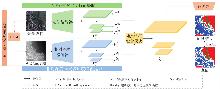
图1
光学-相对深度语义分割的统一编码-解码框架总体结构"
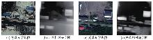
图2
冬夏季节相同区域光学影像及对应相对深度图"
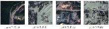
图3
SUSAN数据集的强跨域特征"
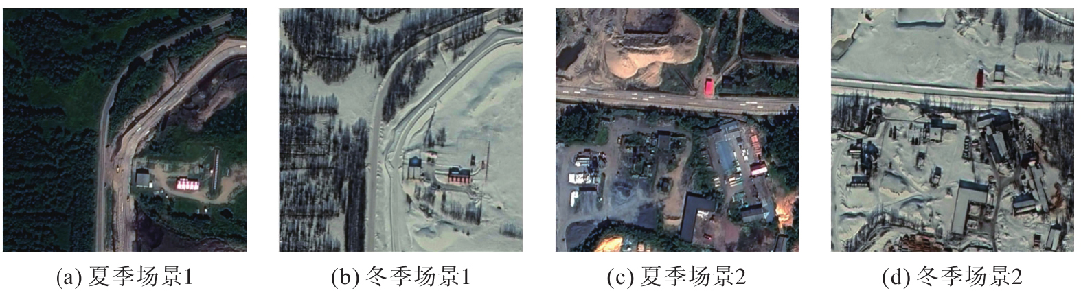

表1
LoveDA数据集城市→乡村跨域语义分割结果对比"
| 方法 | 类型 | 模态 | IoU | mIoU | ||||||
|---|---|---|---|---|---|---|---|---|---|---|
| 背景 | 建筑物 | 道路 | 水系 | 裸地 | 森林 | 农田 | ||||
| CLAN[ | 对抗训练 | 光学 | 22.93 | 44.78 | 25.99 | 46.81 | 10.54 | 37.21 | 24.45 | 30.39 |
| AdaptSegNet[ | 对抗训练 | 26.89 | 40.53 | 30.65 | 50.09 | 16.97 | 32.51 | 28.25 | 32.27 | |
| IAST[ | 自训练 | 29.97 | 49.48 | 28.29 | 64.49 | 2.13 | 33.36 | 61.37 | 38.44 | |
| SegFormer[ | 域泛化 | 26.60 | 55.80 | 35.62 | 65.44 | 17.13 | 40.13 | 39.65 | 40.05 | |
| DCA[ | 自训练 | 36.38 | 55.89 | 40.46 | 62.03 | 22.01 | 38.92 | 60.52 | 45.17 | |
| DAFormer[ | 自训练 | 37.39 | 52.84 | 41.99 | 72.05 | 11.46 | 46.79 | 61.27 | 46.25 | |
| HRDA[ | 自训练 | 36.80 | 64.14 | 40.92 | 71.80 | 14.36 | 47.17 | 68.37 | 49.08 | |
| MIC[ | 自训练 | 39.23 | 61.92 | 43.85 | 72.38 | 13.92 | 47.67 | 68.87 | 49.69 | |
| ST-DASegNet(SegFormer)[ | 对抗训练+自训练 | 36.78 | 59.83 | 43.77 | 73.83 | 19.38 | 49.96 | 67.01 | 50.08 | |
| ConvNeXt-B(基线模型) | 域泛化 | 光学+相对深度 | 35.51 | 56.14 | 40.88 | 70.05 | 13.99 | 48.42 | 64.91 | 47.13 |
| ConvNeXt-B(光学)+ConvNeXt-S(相对深度) | 域泛化 | 36.79 | 59.27 | 46.97 | 71.31 | 19.87 | 41.62 | 67.05 | 48.98 | |
| ConvNeXt-XL(光学)+ConvNeXt-B(相对深度) | 域泛化 | 37.23 | 63.05 | 42.69 | 71.71 | 19.91 | 45.03 | 68.36 | 49.71 | |
| ConvNeXt-B(光学)+ConvNeXt-S(相对深度)+DF+BAAL | 域泛化 | 38.77 | 65.72 | 39.32 | 72.38 | 16.70 | 48.36 | 68.06 | 49.90 | |
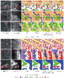
图4
LoveDA测试集城市→乡村、乡村→城市可视化结果"

表2
LoveDA数据集乡村→城市跨域语义分割结果对比"
| 方法 | 类型 | 模态 | IoU | mIoU | ||||||
|---|---|---|---|---|---|---|---|---|---|---|
| 背景 | 建筑物 | 道路 | 水系 | 裸地 | 森林 | 农田 | ||||
| CLAN | 对抗训练 | 光学 | 43.41 | 25.42 | 13.75 | 79.25 | 13.71 | 30.44 | 25.80 | 33.11 |
| AdaptSegNet | 对抗训练 | 42.35 | 23.73 | 15.61 | 81.95 | 13.62 | 28.70 | 22.05 | 32.68 | |
| IAST | 自训练 | 48.57 | 31.51 | 28.73 | 86.01 | 20.29 | 31.77 | 36.50 | 40.48 | |
| SegFormer | 域泛化 | 44.98 | 43.93 | 27.46 | 85.82 | 16.24 | 37.02 | 30.48 | 40.85 | |
| DCA | 自训练 | 45.82 | 49.60 | 51.65 | 80.88 | 16.70 | 42.93 | 36.92 | 46.36 | |
| DAFormer | 自训练 | 50.94 | 56.66 | 62.83 | 89.41 | 11.99 | 45.81 | 25.26 | 48.99 | |
| HRDA | 自训练 | 48.25 | 45.24 | 59.16 | 87.17 | 18.82 | 44.94 | 27.61 | 47.31 | |
| MIC | 自训练 | 50.66 | 49.56 | 49.46 | 87.87 | 19.51 | 43.48 | 34.66 | 49.31 | |
| ST-DASegNet(SegFormer) | 对抗训练+自训练 | 51.01 | 54.23 | 60.52 | 87.31 | 15.18 | 47.23 | 36.26 | 50.28 | |
| ConvNeXt-B(基线模型) | 域泛化 | 46.77 | 46.52 | 37.27 | 82.30 | 17.33 | 42.34 | 36.27 | 44.11 | |
| ConvNeXt-B(光学)+ConvNeXt-S(相对深度) | 域泛化 | 48.23 | 52.68 | 42.70 | 77.18 | 16.62 | 40.85 | 48.86 | 46.73 | |
| ConvNeXt-XL(光学)+ConvNeXt-B(相对深度) | 域泛化 | 光学+相对深度 | 50.56 | 51.81 | 42.89 | 85.11 | 16.69 | 42.67 | 44.00 | 47.68 |
| ConvNeXt-B(光学)+ConvNeXt-S(相对深度)+DF+BAAL | 域泛化 | 48.95 | 52.80 | 52.26 | 84.29 | 18.18 | 44.27 | 46.49 | 49.61 | |
表3
SUSAN子集测试集上的跨域遥感影像语义分割对比结果"
| 方法 | 类型 | 模态 | IoU | mIoU | ||||||||
|---|---|---|---|---|---|---|---|---|---|---|---|---|
| 细粒度类别(道路) | 背景 | 粗粒度类别 | ||||||||||
| 跑道 | 滑行道和保险道 | 其他道路 | 植被 | 水系 | 裸地 | 建筑物 | 冰雪 | |||||
| Swin-Base | 域泛化 | 光学 | 62.08 | 11.50 | 34.65 | 37.19 | 89.64 | 33.11 | 51.69 | 44.68 | 42.38 | 45.21 |
| SegFormer(MiT-B5) | 域泛化 | 47.19 | 10.81 | 33.27 | 37.26 | 90.26 | 43.58 | 50.57 | 43.17 | 46.84 | 44.77 | |
| Mask2Former(Swin-Base) | 域泛化 | 49.08 | 18.38 | 37.06 | 31.60 | 89.65 | 50.82 | 51.05 | 46.15 | 45.06 | 46.54 | |
| DAFormer | 自训练 | 光学 | 46.27 | 14.63 | 36.27 | 36.62 | 86.58 | 46.90 | 53.45 | 42.19 | 33.74 | 44.07 |
| HRDA | 自训练 | 55.36 | 15.90 | 33.47 | 32.91 | 90.22 | 44.58 | 52.82 | 39.15 | 47.57 | 45.59 | |
| MIC | 自训练 | 53.86 | 21.25 | 31.85 | 37.44 | 88.45 | 48.96 | 50.96 | 40.82 | 37.73 | 45.70 | |
| ConvNeXt-B(基线模型) | 域泛化 | 光学+相对深度 | 49.71 | 14.72 | 36.10 | 32.57 | 90.36 | 27.38 | 50.19 | 38.61 | 46.91 | 42.95 |
| ConvNeXt-XL | 域泛化 | 59.76 | 9.91 | 27.87 | 35.10 | 90.80 | 48.82 | 52.64 | 36.26 | 48.76 | 45.55 | |
| ConvNeXt-B(光学)+ConvNeXt-S(相对深度) | 域泛化 | 67.56 | 17.47 | 35.19 | 34.02 | 89.09 | 29.72 | 51.01 | 48.24 | 42.07 | 46.04 | |
| ConvNeXt-XL(光学)+ConvNeXt-B(相对深度) | 域泛化 | 66.35 | 14.45 | 35.83 | 37.21 | 89.65 | 39.06 | 52.28 | 46.44 | 42.91 | 47.13 | |
| ConvNeXt-B(光学)+ConvNeXt-S(相对深度)+DF+BAAL | 域泛化 | 61.30 | 20.56 | 37.45 | 39.64 | 89.20 | 52.62 | 46.53 | 47.27 | 35.66 | 47.80 | |
表4
WHU测试集上的跨域遥感影像语义分割对比结果"
| 方法 | 类型 | 模态 | 建筑物IoU/(%) |
|---|---|---|---|
| DAFormer | 自训练 | 光学 | 67.81 |
| HRDA | 自训练 | 光学 | 73.05 |
| MIC | 自训练 | 光学 | 74.05 |
| ConvNeXt-B(光学)+ConvNeXt-S(相对深度)+DF+BAAL | 域泛化 | 光学+相对深度 | 74.58 |
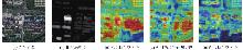
图5
光学、相对深度、融合特征的热力图"
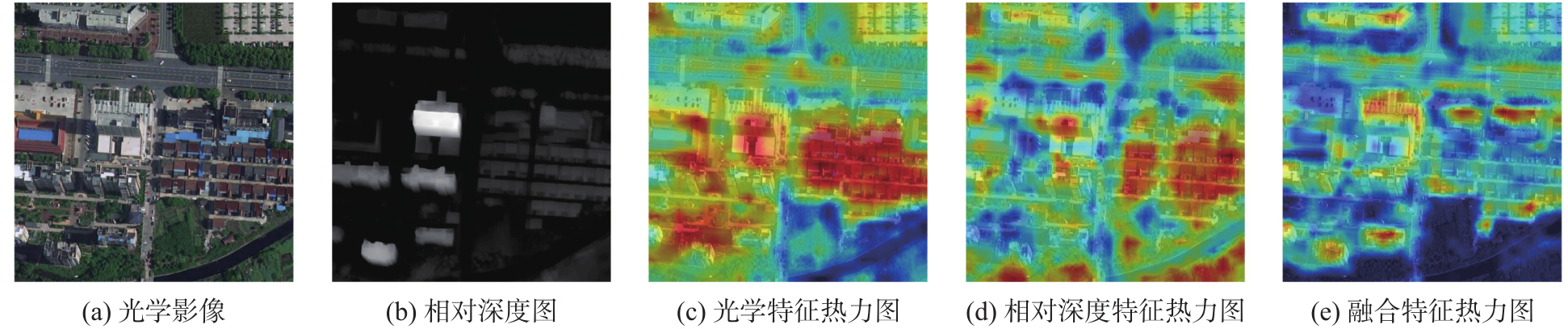
表5
3个模型的参数量、FLOPs和FPS的统计结果"
| 模型 | 模态 | 总参数量(M) | FLOPs(GMacs) | FPS/(张/s) | SUSAN数据集mIoU/(%) |
|---|---|---|---|---|---|
| ConvNeXt-B | 光学 | 120.81 | 291.54 | 67.78 | 42.95 |
| ConvNeXt-XL | 光学 | 388.67 | 532.91 | 45.61 | 45.55 |
| ConvNeXt-B(光学)+ConvNeXt-S(相对深度)+DF+BAAL | 光学+相对深度 | 169.97 | 349.48 | 42.48 | 47.80 |
表6
DF与BAAL在SUSAN子集测试集上的消融试验结果"
| 方法 | DF | BAAL | mIoU |
|---|---|---|---|
| ConvNeXt-B(光学)+ConvNeXt-S(相对深度) | × | × | 46.04 |
| ConvNeXt-B(光学)+ConvNeXt-S(相对深度) | √ | × | 47.53 |
| ConvNeXt-B(光学)+ConvNeXt-S(相对深度) | × | √ | 47.05 |
| ConvNeXt-B(光学)+ConvNeXt-S(相对深度) | √ | √ | 47.80 |
表7
DF与BAAL在LoveDA数据集城市→乡村上的消融试验结果"
| 方法 | DF | BAAL | mIoU |
|---|---|---|---|
| ConvNeXt-B(光学)+ConvNeXt-S(相对深度) | × | × | 48.98 |
| ConvNeXt-B(光学)+ConvNeXt-S(相对深度) | √ | × | 49.55 |
| ConvNeXt-B(光学)+ConvNeXt-S(相对深度) | × | √ | 49.62 |
| ConvNeXt-B(光学)+ConvNeXt-S(相对深度) | √ | √ | 49.90 |
表8
不同深度估计模型对比试验"
| 模型 | 深度估计模型 | SUSAN数据集mIoU |
|---|---|---|
| ConvNeXt-B(光学)+ConvNeXt-S(相对深度)+BAAL+DF | DAM V1 | 47.80 |
| DAM V2 | 47.92 |
表9
SUSAN数据集不同融合方式对比试验"
| 模型 | 融合方式 | 总参数量(M) | FLOPs(GMacs) | FPS/(张/s) | mIoU/(%) |
|---|---|---|---|---|---|
| ConvNeXt-B(光学)+ConvNeXt-S(相对深度)+BAAL | 拼接 | 175.72 | 339.38 | 44.53 | 47.05 |
| 交叉注意力 | 177.33 | 350.72 | 37.52 | 47.44 | |
| Adapter | 168.62 | 344.00 | 42.40 | 47.31 | |
| DF | 169.97 | 349.48 | 42.48 | 47.80 |
| [1] | Wu Kang, Zhang Yingying, Ru Lixiang, et al. A semantic-enhanced multi-modal remote sensing foundation model for Earth observation[J]. Nature Machine Intelligence, 2025, 7(8): 1235-1249. |
| [2] | Li Yansheng, Shi Te, Zhang Yongjun, et al. Learning deep semantic segmentation network under multiple weakly-supervised constraints for cross-domain remote sensing image semantic segmentation[J]. ISPRS Journal of Photogrammetry and Remote Sensing, 2021, 175: 20-33. |
| [3] |
沈秭扬, 倪欢, 管海燕. 遥感图像跨域语义分割的无监督域自适应对齐方法[J]. 测绘学报, 2023, 52(12): 2115-2126. DOI: .
doi: 10.11947/j.AGCS.2023.20220483 |
|
Shen Ziyang, Ni Huan, Guan Haiyan. Unsupervised domain adaptation alignment method for cross-domain semantic segmentation of remote sensing images[J]. Acta Geodaetica et Cartographica Sinica, 2023, 52(12): 2115-2126. DOI: .
doi: 10.11947/j.AGCS.2023.20220483 |
|
| [4] | 张继贤, 顾海燕, 杨懿, 等. 高分辨率遥感影像智能解译研究进展与趋势[J]. 遥感学报, 2021, 25(11): 2198-2210. |
| Zhang Jixian, Gu Haiyan, Yang Yi, et al. Research progress and trend of high-resolution remote sensing imagery intelligent interpretation[J]. Journal of Remote Sensing, 2021, 25(11): 2198-2210. | |
| [5] |
顾海燕, 杨懿, 李海涛, 等. 高分辨率遥感影像样本库动态构建与智能解译应用[J]. 测绘学报, 2024, 53(6): 1165-1179. DOI: .
doi: 10.11947/j.AGCS.2024.20230469 |
|
Gu Haiyan, Yang Yi, Li Haitao, et al. Dynamic construction of high-resolution remote sensing image sample datasets and intelligent interpretation applications[J]. Acta Geodaetica et Cartographica Sinica, 2024, 53(6): 1165-1179. DOI: .
doi: 10.11947/j.AGCS.2024.20230469 |
|
| [6] | Li Da, Yang Yongxin, Song Yizhe, et al. Learning to generalize: Meta-learning for domain generalization[C]//Proceedings of 2018 AAAI Conference on Artificial Intelligence. 2018, 32(1): 11596. |
| [7] | Kim D, Yoo Y, Park S, et al. SelfReg: self-supervised contrastive regularization for domain generalization[C]//Proceedings of 2021 IEEE/CVF International Conference on Computer Vision (ICCV). Montreal: IEEE, 2021: 9599-9608. |
| [8] | Pan Xingang, Luo Ping, Shi Jianping, et al. Two at once: enhancing learning and generalization capacities via IBN-net[C]//Proceedings of 2018 Computer Vision. Cham: Springer International Publishing, 2018: 484-500. |
| [9] | Hoyer L, Dai Dengxin, Van Gool L. DAFormer: improving network architectures and training strategies for domain-adaptive semantic segmentation[C]//Proceedings of 2022 IEEE/CVF Conference on Computer Vision and Pattern Recognition (CVPR). New Orleans: IEEE, 2022: 9914-9925. |
| [10] | Hoyer L, Dai Dengxin, Wang Haoran, et al. MIC: masked image consistency for context-enhanced domain adaptation[C]//Proceedings of 2023 IEEE/CVF Conference on Computer Vision and Pattern Recognition. Vancouver: IEEE, 2023: 11721-11732. |
| [11] | Hoyer L, Dai Dengxin, Van Gool L. Domain adaptive and generalizable network architectures and training strategies for semantic image segmentation[J]. IEEE Transactions on Pattern Analysis and Machine Intelligence, 2024, 46(1): 220-235. |
| [12] | Zhao Qi, Lyu Shuchang, Zhao Hongbo, et al. Self-training guided disentangled adaptation for cross-domain remote sensing image semantic segmentation[J]. International Journal of Applied Earth Observation and Geoinformation, 2024, 127: 103646. |
| [13] | Chen Jie, Zhu Jingru, He Peien, et al. Unsupervised domain adaptation for building extraction of high-resolution remote sensing imagery based on decoupling style and semantic features[J]. IEEE Transactions on Geoscience and Remote Sensing, 2024, 62: 4406917. |
| [14] | Hu Wenshuai, Li Wei, Li Hengchao, et al. Unsupervised domain adaptation with hierarchical masked dual-adversarial network for end-to-end classification of multisource remote sensing data[J]. IEEE Transactions on Geoscience and Remote Sensing, 2025, 63: 4409917. |
| [15] | Guo Xin, Lao Jiangwei, Dang Bo, et al. SkySense: a multi-modal remote sensing foundation model towards universal interpretation for earth observation imagery[C]//Proceedings of 2024 IEEE/CVF Conference on Computer Vision and Pattern Recognition. Seattle: IEEE, 2024: 27662-27673. |
| [16] | Li Xuyang, Li Chenyu, Ghamisi P, et al. FlexiMo: a flexible remote sensing foundation model[J]. IEEE Transactions on Geoscience and Remote Sensing, 2026, 64: 5606516. |
| [17] | Li Xuyang, Li Chenyu, Vivone G, et al. SeaMo: a season-aware multimodal foundation model for remote sensing[J]. Information Fusion, 2026, 125: 103334. |
| [18] | Wang Junjue, Zheng Zhuo, Ma Ailong, et al. LoveDA: a remote sensing land-cover dataset for domain adaptive semantic segmentation[PP/OL]. V6. arXiv (2022-05-31) [2026-04-16]. https://doi.org/10.48550/arXiv.2110.08733. |
| [19] | Yang Lihe, Kang Bingyi, Huang Zilong, et al. Depth anything: unleashing the power of large-scale unlabeled data[C]//Proceedings of 2024 IEEE/CVF Conference on Computer Vision and Pattern Recognition. Seattle: IEEE, 2024: 10371-10381. |
| [20] | Liu Zhuang, Mao Hanzi, Wu Chaoyuan, et al. A ConvNet for the 2020s[C]//Proceedings of 2022 IEEE/CVF Conference on Computer Vision and Pattern Recognition. New Orleans: IEEE, 2022: 11966-11976. |
| [21] | Liu Ze, Lin Yutong, Cao Yue, et al. Swin transformer: hierarchical vision transformer using shifted windows[C]//Proceedings of 2021 IEEE/CVF International Conference on Computer Vision. Montreal: IEEE, 2021: 9992-10002. |
| [22] | Berman M, Triki A R, Blaschko M B. The lovasz-softmax loss: a tractable surrogate for the optimization of the intersection-over-union measure in neural networks[C]//Proceedings of 2018 IEEE/CVF Conference on Computer Vision and Pattern Recognition. Salt Lake City: IEEE, 2018: 4413-4421. |
| [23] | Ji Shunping, Wei Shiqing, Lu Meng. Fully convolutional networks for multisource building extraction from an open aerial and satellite imagery data set[J]. IEEE Transactions on Geoscience and Remote Sensing, 2019, 57(1): 574-586. |
| [24] | Luo Yawei, Zheng Liang, Guan Tao, et al. Taking a closer look at domain shift: category-level adversaries for semantics consistent domain adaptation[C]//Proceedings of 2019 IEEE/CVF Conference on Computer Vision and Pattern Recognition. Long Beach: IEEE, 2019: 2502-2511. |
| [25] | Tsai Y H, Hung W C, Schulter S, et al. Learning to adapt structured output space for semantic segmentation[C]//Proceedings of 2018 IEEE/CVF Conference on Computer Vision and Pattern Recognition. Salt Lake City: IEEE, 2018: 7472-7481. |
| [26] | Mei Ke, Zhu Chuang, Zou Jiaqi, et al. Instance adaptive self-training for unsupervised domain adaptation[C]//Proceedings of 2020 Computer Vision. Cham: Springer International Publishing, 2020: 415-430. |
| [27] | Wu Linshan, Lu Ming, Fang Leyuan. Deep covariance alignment for domain adaptive remote sensing image segmentation[J]. IEEE Transactions on Geoscience and Remote Sensing, 2022, 60: 5620811. |
| [28] | Xie Enze, Wang Wenhai, Yu Zhiding, et al. segFormer: Simple and efficient design for semantic segmentation with transformers[J]. Advances in Neural Information Processing Systems, 2021, 34: 12077-12090. |
| [29] | Xiao Tete, Liu Yingcheng, Zhou Bolei, et al. Unified perceptual parsing for scene understanding[C]//Proceedings of 2018 Computer Vision-ECCV 2018. Cham: Springer International Publishing, 2018: 432-448. |
| [30] | Yang Lihe, Kang Bingyi, Huang Zilong, et al. Depth anything V2[PP/OL]. V2. arXiv (2024-10-20) [2026-04-16]. https://doi.org/10.48550/arXiv.2406.09414. |
| [31] | Ebrahimi S, Arik S O, Nama T, et al. CROME: cross-modal adapters for efficient multimodal LLM[PP/OL]. arXiv (2024-08-13) [2026-04-16]. https://doi.org/10.48550/arXiv.2408.06610. |
| [32] | Zhang Haodi, Yu Anzhu, Gao Kuiliang, et al. M2Caps: learning multi-modal capsules of optical and SAR images for land cover classification[J]. International Journal of Digital Earth, 2025, 18: 2447347. |
| [1] | 陈西江, 曾敏坤, 宣伟, 邹进贵, 花向红. 多尺度超体素特征聚合网络的三维点云语义分割[J]. 测绘学报, 2026, 55(8): 1414-1424. |
| [2] | 王泽矫, 向隆刚, 王猛, 王兴娟, 刘清. 融合层级特征与多样化注意力的道路面与中心线协同提取网络[J]. 测绘学报, 2026, 55(3): 548-563. |
| [3] | 黄文君, 孙群, 徐青, 范龙, 余岸竹, 张付兵. 融合频域特征与地形先验的全球沿海DEM超分辨率重建方法[J]. 测绘学报, 2025, 54(8): 1518-1531. |
| [4] | 万杰, 谢忠, 徐永洋, 陶留锋. 面向城市道路场景的车载LiDAR点云语义分割U形图卷积网络方法[J]. 测绘学报, 2025, 54(7): 1280-1293. |
| [5] | 赵一鸣, 胡克林, 涂可龙, 卿雅娴, 杨超, 祁昆仑, 吴华意. 基于SAR与光学遥感影像融合的多标签场景分类方法[J]. 测绘学报, 2025, 54(5): 911-923. |
| [6] | 曹云刚, 杨鹏, 龚江波, 朱高, 沈星宇. 空间关系增强与异构特征融合相结合的道路信息提取方法[J]. 测绘学报, 2025, 54(12): 2219-2232. |
| [7] | 龚良雄, 李星华, 程远明, 赵兴友, 谢仁平, 王红根. 时空差异增强与自适应特征融合的轻量级遥感影像变化检测网络[J]. 测绘学报, 2025, 54(1): 136-153. |
| [8] | 唐建波, 胡致远, 彭举, 夏何炎, 丁俊杰, 张玉玉, 梅小明. 融合视觉特征与运动特征的众源轨迹数据道路交叉口识别方法[J]. 测绘学报, 2025, 54(1): 182-193. |
| [9] | 胡波, 陈翰新, 任松, 屈英豪, 刘清屹, 涂歆玥, 王大涛. 一种基于分割掩码的隧道裂缝病害自动识别后处理算法[J]. 测绘学报, 2024, 53(9): 1715-1724. |
| [10] | 张付兵, 孙群, 马京振, 孙士杰, 温伯威. 融合全局和局部特征的建筑物形状智能分类方法[J]. 测绘学报, 2024, 53(9): 1842-1852. |
| [11] | 鄢薪, 慎利, 潘俊杰, 戴延帅, 王继成, 郑晓莉, 李志林. 多尺度特征融合与空间优化的弱监督高分遥感建筑变化检测[J]. 测绘学报, 2024, 53(8): 1586-1597. |
| [12] | 徐涛, 杨元维, 高贤君, 王志威, 潘越, 李少华, 许磊, 王艳军, 刘波, 余静, 吴凤敏, 孙浩宇. 融合图卷积与多尺度特征的接触网点云语义分割[J]. 测绘学报, 2024, 53(8): 1624-1633. |
| [13] | 林云浩, 王艳军, 李少春, 蔡恒藩. 一种耦合DeepLab与Transformer的农作物种植类型遥感精细分类方法[J]. 测绘学报, 2024, 53(2): 353-366. |
| [14] | 张彩丽, 向隆刚, 李雅丽, 高松峰, 潘传姣. 路段级导航属性信息挖掘[J]. 测绘学报, 2024, 53(2): 367-378. |
| [15] | 孙根云, 孙超, 张爱竹. 融合多尺度与边缘特征的道路提取网络[J]. 测绘学报, 2024, 53(12): 2233-2243. |
| 阅读次数 | ||||||
|
全文 |
|
|||||
|
摘要 |
|
|||||
