


测绘学报 ›› 2026, Vol. 55 ›› Issue (8): 1439-1451.doi: 10.11947/j.AGCS.2026.20250415
• 摄影测量学与遥感 • 上一篇
朱涵( ), 戴晨光, 张振超(), 刘宣广, 卢金浩
收稿日期:2025-10-13
修回日期:2026-07-20
发布日期:2026-09-09
通讯作者:
张振超
E-mail:15906119415@163.com;zhzhc_1@163.com
作者简介:朱涵(2002—),女,硕士生,研究方向为三维点云变化检测。E-mail:15906119415@163.com
基金资助:
Han Zhu(), Chenguang Dai, Zhenchao Zhang(), Xuanguang Liu, Jinhao Lu
Received:2025-10-13
Revised:2026-07-20
Published:2026-09-09
Contact:
Zhenchao Zhang
E-mail:15906119415@163.com;zhzhc_1@163.com
About author:Zhu Han (2002—), female, postgraduate, majors in 3D point cloud change detection. E-mail: 15906119415@163.com
Supported by:摘要:
三维变化检测旨在从同一场景不同时相的点云中获取地物变化信息,对理解地表动态变化过程至关重要。然而,现有基于深度学习的点云变化检测方法常因忽视局部几何细节和全局上下文特征建模不足,导致在点云密度不均、存在孔洞及视角重叠的复杂城市场景中性能受限。本文提出一种基于几何结构优化和熵注意力机制的点云变化检测方法。在编码器阶段组合利用局部复杂度分析模块和分层采样模块,通过融合点云曲率、密度、信息熵三维特征,共同量化点云邻域的空间分布。并以此作为下采样先验知识计算采样概率,通过自适应的分层采样方法在缩小点云规模的同时优化宏观几何结构,兼顾了点云全局覆盖和重点区域增强。改进了传统双路径注意力机制,将信息熵作为先验信息,通过对注意力权重施加熵偏置,动态引导空间与特征通道注意力聚焦于结构复杂的高信息量区域,增强了全局上下文特征表征。选取7种主流基线网络,在SLPCCD街景三维变化检测数据集和Urb3DCD模拟机载激光点云变化检测数据集上进行模型对比试验,结果表明,本文方法在定量和定性分析方面均优于其他主流网络,在SLPCCD数据集上的平均交并比比基线网络3DCDNet提升超17.01%,比先前最优模型Ms-DANet提升了3.35%。本文方法能够有效改善因点云密度不均、点云孔洞、视角重叠造成的错检及漏检问题。
中图分类号:
朱涵, 戴晨光, 张振超, 刘宣广, 卢金浩. 基于几何结构优化和熵注意力机制的点云变化检测方法[J]. 测绘学报, 2026, 55(8): 1439-1451.
Han Zhu, Chenguang Dai, Zhenchao Zhang, Xuanguang Liu, Jinhao Lu. Point cloud change detection with geometric structure refinement and entropy-attention mechanism[J]. Acta Geodaetica et Cartographica Sinica, 2026, 55(8): 1439-1451.
图1
GS-EANet整体框架"
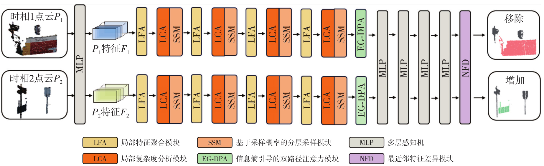
图2
点云局部几何复杂度分析"
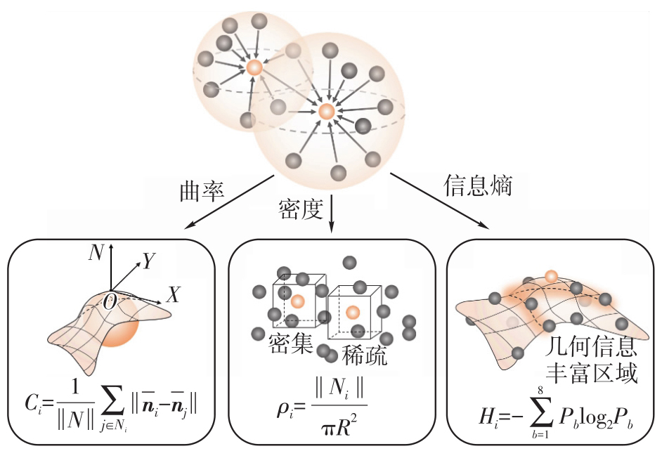
图3
局部复杂度分析模块和分层采样模块协同作用"
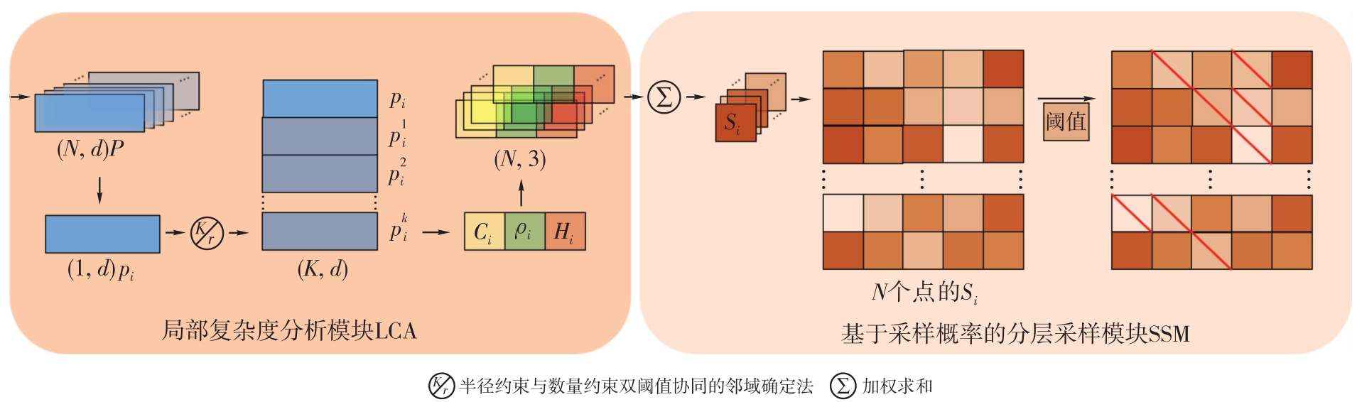
图4
信息熵引导的双路径注意力机制"
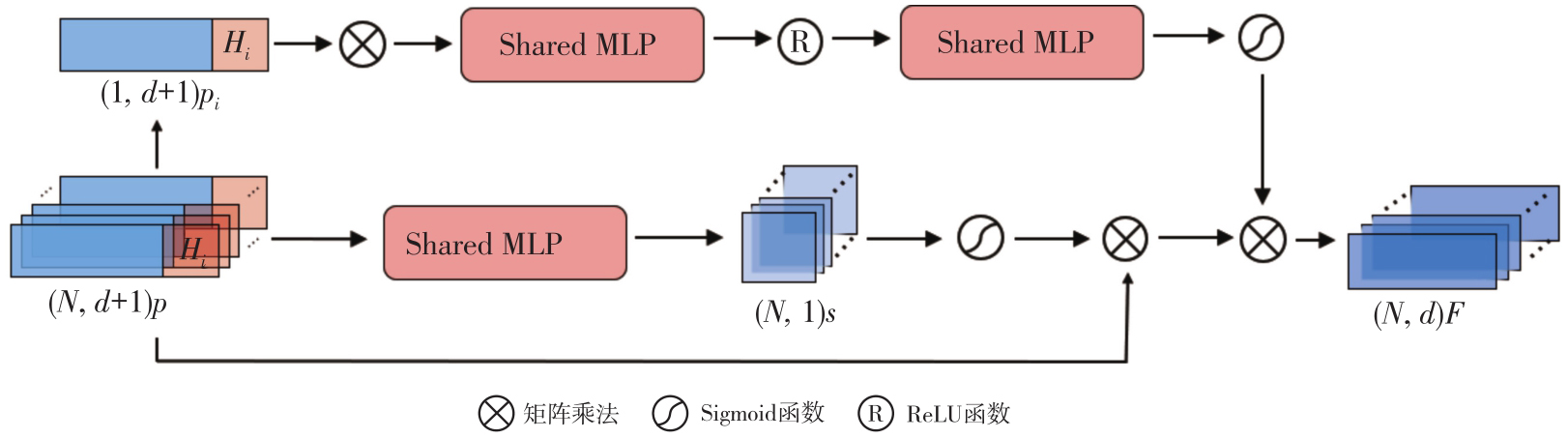
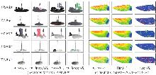
图5
数据集样本"


表1
SLPCCD数据集上的精度指标对比"
| 模型 | IoU | OA | mIoU | ||
|---|---|---|---|---|---|
| 移除 | 增加 | 不变 | |||
| PointNet[ | 23.47 | 26.84 | 89.36 | 89.16 | 46.56 |
| GCN[ | 28.23 | 35.85 | 88.61 | 89.80 | 50.90 |
| PointNet++[ | 45.36 | 57.21 | 95.31 | 96.03 | 65.96 |
| PointMLP[ | 46.83 | 40.11 | 90.35 | 92.56 | 59.10 |
| 3DCDNet[ | 52.82 | 58.23 | 93.87 | 93.51 | 68.31 |
| PGN3DCD[ | 74.58 | 75.25 | 96.67 | 96.97 | 82.17 |
| Ms-DANet[ | 73.54 | 75.50 | 96.88 | 97.14 | 81.97 |
| GS-EANet | 79.84 | 78.14 | 97.98 | 97.56 | 85.32 |
表2
模型复杂度和推理效率对比实验结果"
| 模型 | FLOPs/G | Params/M | 推理速度/(帧/s) | mIoU/(%) |
|---|---|---|---|---|
| 3DCDNet[ | 88.20 | 6.68 | 53.29 | 68.31 |
| Ms-DANet[ | 106.31 | 6.37 | 44.73 | 81.97 |
| GS-EANet | 93.41 | 6.45 | 48.80 | 85.32 |
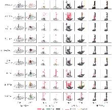
图6
SLPCCD数据集上可视化结果对比注:红色框选为正确检测结果,黄色框选为错误检测结果。"

表3
消融试验精度评价结果"
| 网络 | LCA | SSM | DPA | EG-DPA | IoU | OA | mIoU | ||
|---|---|---|---|---|---|---|---|---|---|
| 移除 | 增加 | 不变 | |||||||
| 3DCDNet[ | × | × | × | × | 52.82 | 58.23 | 93.87 | 93.51 | 68.31 |
| GS-EANet-1 | √ | × | × | × | 55.98 | 60.21 | 94.30 | 94.03 | 70.16 |
| GS-EANet-2 | × | × | √ | × | 58.69 | 62.06 | 93.99 | 93.74 | 71.58 |
| GS-EANet-3 | × | × | × | √ | 63.96 | 64.87 | 95.53 | 94.79 | 74.79 |
| GS-EANet-4 | √ | √ | × | × | 60.32 | 62.98 | 95.02 | 95.04 | 72.77 |
| GS-EANet-5 | √ | √ | √ | × | 74.08 | 75.14 | 97.11 | 96.82 | 82.11 |
| GS-EANet | √ | √ | × | √ | 79.84 | 78.14 | 97.98 | 97.56 | 85.32 |
表4
Urb3DCD数据集上的精度指标对比"
| 数据集 | 网络 | IoU | OA | mIoU | ||
|---|---|---|---|---|---|---|
| 移除 | 增加 | 不变 | ||||
| 子数据集1-b ALS Low Res | 3DCDNet[ | 37.62 | 45.84 | 98.63 | 96.21 | 60.70 |
| Ms-DANet[ | 53.10 | 62.45 | 98.55 | 98.57 | 71.37 | |
| GS-EANet | 56.12 | 65.09 | 98.64 | 98.37 | 73.28 | |
| 子数据集1-a ALS Low Res | 3DCDNet[ | 48.31 | 62.17 | 98.03 | 96.58 | 69.50 |
| Ms-DANet[ | 63.86 | 78.67 | 99.04 | 99.06 | 80.52 | |
| GS-EANet | 66.21 | 78.22 | 99.65 | 98.89 | 81.36 | |
| 子数据集1-c ALS Low Res | 3DCDNet[ | 55.03 | 62.31 | 99.08 | 98.14 | 72.14 |
| Ms-DANet[ | 66.85 | 83.49 | 99.20 | 99.22 | 83.18 | |
| GS-EANet | 70.66 | 86.21 | 99.05 | 98.98 | 85.31 | |
| 子数据集2 ALS High Res | 3DCDNet[ | 55.63 | 70.59 | 99.03 | 98.67 | 75.08 |
| Ms-DANet[ | 67.74 | 76.59 | 99.06 | 99.08 | 81.13 | |
| GS-EANet | 70.36 | 80.21 | 99.23 | 99.21 | 83.27 | |
| 子数据集3 ALS High Noise | 3DCDNet[ | 40.31 | 58.69 | 99.02 | 98.32 | 65.80 |
| Ms-DANet[ | 55.27 | 72.15 | 98.92 | 98.93 | 75.45 | |
| GS-EANet | 65.04 | 69.89 | 99.23 | 99.05 | 78.05 | |
| 子数据集4 Photogrammetry | 3DCDNet[ | 51.23 | 65.21 | 98.06 | 98.25 | 71.74 |
| Ms-DANet[ | 61.42 | 76.95 | 99.15 | 99.17 | 79.17 | |
| GS-EANet | 67.32 | 78.21 | 99.06 | 99.12 | 81.53 | |
| 子数据集5 Multi-Sensor | 3DCDNet[ | 45.63 | 62.58 | 98.12 | 98.62 | 68.78 |
| Ms-DANet[ | 54.84 | 71.96 | 98.68 | 98.71 | 75.16 | |
| GS-EANet | 59.98 | 76.36 | 99.06 | 99.12 | 78.47 | |
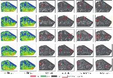
图7
Urb3DCD数据集上的全局可视化结果对比"
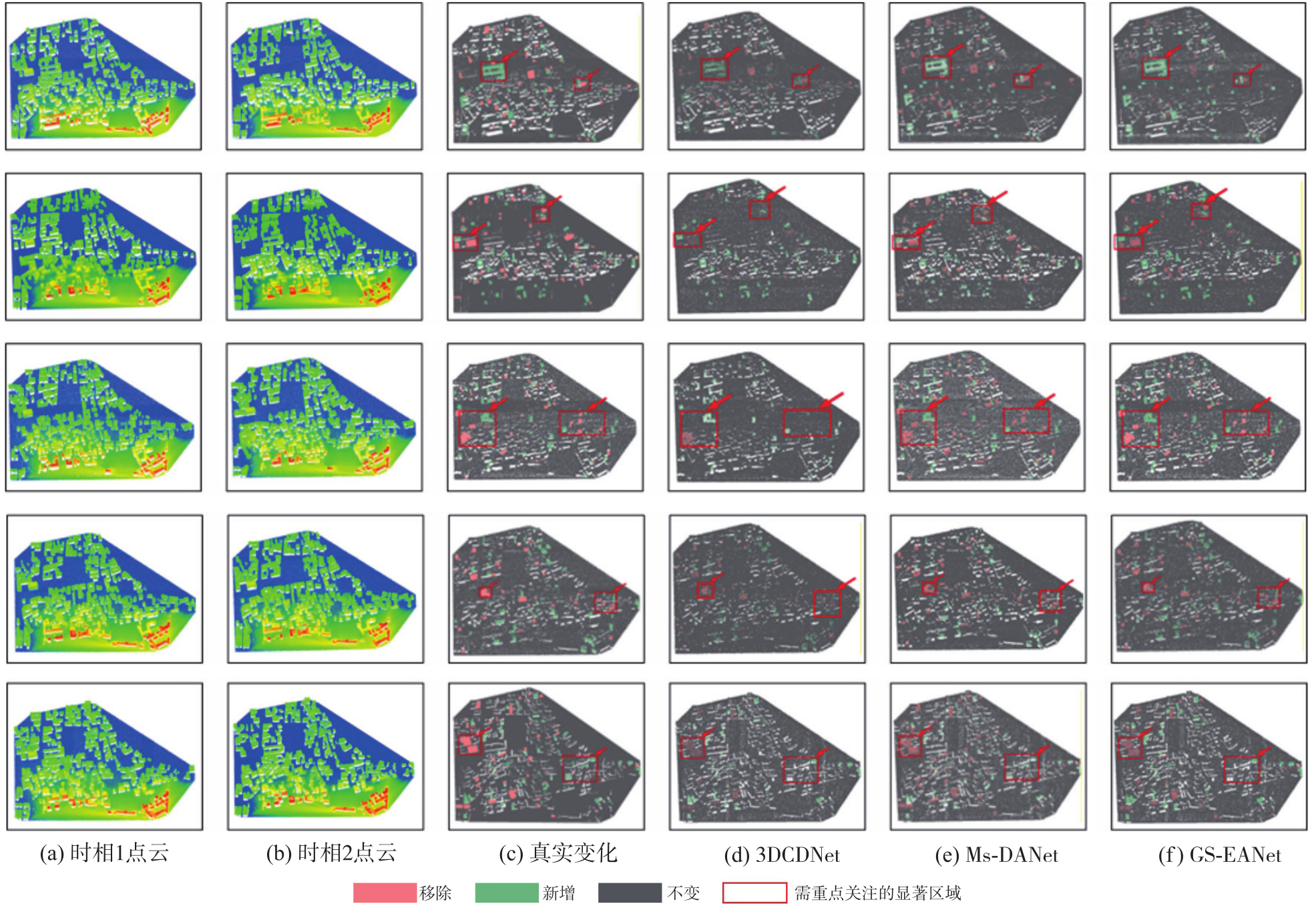
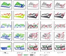
图8
Urb3DCD数据集上的建筑级可视化结果对比"

表5
Urb3DCD子数据集的最优权重系数与跨区域迁移试验结果"
| 数据集 | Ms-DANet的mIoU/(%) | GS-EANet | 跨区域迁移试验后的mIoU/(%) | 跨区域迁移精度变化情况/(%) | |
|---|---|---|---|---|---|
| 最优权重系数组合(ωC,ωH,ωρ) | GS-EANet最优mIoU/(%) | ||||
| Urb3DCD 1-a | 71.37 | (0.4,0.4,0.2) | 73.28 | 73.06 | ↓0.22 |
| Urb3DCD 1-b | 80.52 | (0.4,0.4,0.2) | 81.36 | 81.22 | ↓0.14 |
| Urb3DCD 1-c | 83.18 | (0.4,0.4,0.2) | 85.31 | 85.08 | ↓0.23 |
| Urb3DCD 2 | 81.13 | (0.3,0.5,0.2) | 83.27 | 82.89 | ↓0.38 |
| Urb3DCD 3 | 75.45 | (0.2,0.5,0.3) | 78.05 | 77.53 | ↓0.52 |
| Urb3DCD 4 | 79.17 | (0.3,0.3,0.4) | 81.53 | 81.39 | ↓0.14 |
| Urb3DCD 5 | 75.16 | (0.3,0.2,0.5) | 78.47 | 78.15 | ↓0.33 |
| [1] |
李朋飞, 李豆, 胡晋飞, 等. 机载LiDAR监测黄土高原土壤侵蚀的能力评估[J]. 测绘学报, 2023, 52(8): 1342-1354. DOI: .
doi: 10.11947/j.AGCS.2023.20210698 |
|
Li Pengfei, Li Dou, Hu Jinfei, et al. Assessing the ability of airborne LiDAR to monitor soil erosion on the Chinese Loess Plateau[J]. Acta Geodaetica et Cartographica Sinica, 2023, 52(8): 1342-1354. DOI: .
doi: 10.11947/j.AGCS.2023.20210698 |
|
| [2] | Khan S H, He Xuming, Porikli F, et al. Forest change detection in incomplete satellite images with deep neural networks[J]. IEEE Transactions on Geoscience and Remote Sensing, 2017, 55(9): 5407-5423. |
| [3] |
杨安秀. 机载LiDAR测深点云滤波与分类方法研究[J]. 测绘学报, 2023, 52(7): 1234. DOI: .
doi: 10.11947/j.AGCS.2023.20220015 |
|
Yang Anxiu. Research on the point cloud filtering and classification for airborne LiDAR bathymetry[J]. Acta Geodaetica et Cartographica Sinica, 2023, 52(7): 1234. DOI: .
doi: 10.11947/j.AGCS.2023.20220015 |
|
| [4] | Wang Xiaochen, Ma Hongchao, Zhang Liang, et al. Point cloud classification and accuracy analysis based on feature fusion[J]. Journal of Geodesy and Geoinformation Science, 2021, 4(3): 38-48. |
| [5] | Chen Hao, Shi Zhenwei. A spatial-temporal attention-based method and a new dataset for remote sensing image change detection[J]. Remote Sensing, 2020, 12(10): 1662. |
| [6] | Lu Miao, Chen Jun, Tang Huajun, et al. Land cover change detection by integrating object-based data blending model of Landsat and MODIS[J]. Remote Sensing of Environment, 2016, 184: 374-386. |
| [7] | Yang Juntao, Kang Zhizhong, Yang Zhou. A robust model fitting-based method for transmission line extraction from airborne LiDAR point cloud data[J]. Journal of Geodesy and Geoinformation Science, 2021, 4(3): 60-71. |
| [8] |
杨必胜, 韩旭, 董震. 适用于城市场景大规模点云语义标识的深度学习网络[J]. 测绘学报, 2021, 50(8): 1059-1067. DOI: .
doi: 10.11947/j.AGCS.2021.20210093 |
|
Yang Bisheng, Han Xu, Dong Zhen. A deep learning network for semantic labeling of large-scale urban point clouds[J]. Acta Geodaetica et Cartographica Sinica, 2021, 50(8): 1059-1067. DOI: .
doi: 10.11947/j.AGCS.2021.20210093 |
|
| [9] | Yan L, Dai J, Tan J, et al. Global fine registration of point cloud in LiDAR SLAM based on pose graph[J]. Journal of Geodesy and Geoinformation Science, 2020, 3(2): 26-35. |
| [10] | Wang Zhixue, Zhang Yu, Luo Lin, et al. TransCD: scene change detection via transformer-based architecture[J]. Optics Express, 2021, 29(25): 41409. |
| [11] | Alcantarilla P F, Stent S, Ros G, et al. Street-view change detection with deconvolutional networks[J]. Autonomous Robots, 2018, 42(7): 1301-1322. |
| [12] | Li Bin, Zhao Xiaofa, Chen Yong, et al. Three dimensional laser point cloud slicing method for calculating irregular volume[J]. Journal of Geodesy and Geoinformation Science, 2019, 2(4): 31-43. |
| [13] | Menderes A, Erener A, Sarp G. Automatic detection of damaged buildings after earthquake hazard by using remote sensing and information technologies[J]. Procedia Earth and Planetary Science, 2015, 15: 257-262. |
| [14] | Zhu Zan, Gan Shu, Wang Jianqi, et al. A novel airborne 3D laser point cloud hole repair algorithm considering topographic features[J]. Journal of Geodesy and Geoinformation Science, 2020, 3(3): 29-38. |
| [15] | Xiao Wen, Cao Hui, Tang Miao, et al. 3D urban object change detection from aerial and terrestrial point clouds: a review[J]. International Journal of Applied Earth Observation and Geoinformation, 2023, 118: 103258. |
| [16] | 刘宣广, 李玉洁, 张振超, 等. CVS-Net:基于时空关系建模与边缘信息强化的遥感影像语义变化检测方法[J]. 地球信息科学学报, 2025, 27(5): 1144-1162. |
| Liu Xuanguang, Li Yujie, Zhang Zhenchao, et al. CVS-net: semantic change detection in remote sensing images using spatial-temporal modeling and edge enhancement[J]. Journal of Geo-information Science, 2025, 27(5): 1144-1162. | |
| [17] | 刘宣广, 李蒙蒙, 汪小钦, 等. 基于面向对象孪生神经网络的高分辨率遥感影像建筑物变化检测[J]. 遥感学报, 2024, 28(2): 437-454. |
| Liu Xuanguang, Li Mengmeng, Wang Xiaoqin, et al. Use of object-based siamese neural network to build change detection from very high resolution remote-sensing images[J]. Journal of Remote Sensing, 2024, 28(2): 437-454. | |
| [18] | Zhang L, Zhang Y, Chen Z, et al. Splitting and merging based multi-model fitting for point cloud segmentation[J]. Journal of Geodesy and Geoinformation Science, 2019, 2(2): 78-89. |
| [19] | Sun Yifan, Dai Chenguang, Li Wenke, et al. Supervised contrastive learning for indoor point cloud over segmentation[J]. IEEE Transactions on Multimedia, 2025, 27: 9189-9201. |
| [20] | Kharroubi A, Poux F, Ballouch Z, et al. Three dimensional change detection using point clouds: a review[J]. Geomatics, 2022, 2(4): 457-485. |
| [21] | Williams R D. DEMs of difference[J]. Geomorphological Techniques, 2012, 2(3): 1-17. |
| [22] | Bailey G, Li Yingkui, McKinney N, et al. Las2DoD: change detection based on digital elevation models derived from dense point clouds with spatially varied uncertainty[J]. Remote Sensing, 2022, 14(7): 1537. |
| [23] | Scott C P, Beckley M, Phan M, et al. Statewide USGS 3DEP LiDAR topographic differencing applied to Indiana, USA[J]. Remote Sensing, 2022, 14(4): 847. |
| [24] | Girardeau-Montaut D, Roux M, Raphaël M, et al. Change detection on points cloud data acquired with a ground laser scanner[J]. ISPRS Journal of Photogrammetry and Remote Sensing, 2005, 36: 30-35. |
| [25] | Lague D, Brodu N, Leroux J. Accurate 3D comparison of complex topography with terrestrial laser scanner: application to the Rangitikei canyon (N-Z)[J]. ISPRS Journal of Photogrammetry and Remote Sensing, 2013, 82: 10-26. |
| [26] | Stilla U, Xu Y. Change detection of urban objects using 3D point clouds: a review[J]. ISPRS Journal of Photogrammetry and Remote Sensing, 2023, 197: 228-255. |
| [27] | Wang Zhixue, Zhang Yu, Luo Lin, et al. An end-to-end point-based method and a new dataset for street-level point cloud change detection[J]. IEEE Transactions on Geoscience and Remote Sensing, 2023, 61: 5703015. |
| [28] | Hu Qingyong, Yang Bo, Xie Linhai, et al. RandLA-net: efficient semantic segmentation of large-scale point clouds[C]//Proceedings of 2020 IEEE/CVF Conference on Computer Vision and Pattern Recognition. Seattle: IEEE, 2020: 11105-11114. |
| [29] | Han Ming, Sha Jianjun, Wang Yanheng, et al. PBFormer: point and bi-spatiotemporal transformer for pointwise change detection of 3D urban point clouds[J]. Remote Sensing, 2023, 15(9): 2314. |
| [30] | Zhan Wenxiao, Cheng Ruozhen, Chen Jing. PGN3DCD: prior-knowledge-guided network for urban 3D point cloud change detection[J]. IEEE Transactions on Geoscience and Remote Sensing, 2024, 62: 5705415. |
| [31] | Lu Jinhao, Dai Chenguang, Zhang Zhenchao, et al. Ms-DANet: multiscale difference-aware network for 3D point cloud change detection[J]. IEEE Transactions on Geoscience and Remote Sensing, 2025, 63: 5702113. |
| [32] | Shen Zhao, Jia Xin, Zhang Jinglei. Rotation-invariant convolution with point sort and curvature radius for point cloud classification and segmentation[J]. IEEE Access, 2025, 13: 10432-10446. |
| [33] | Li Yaqian, Zhang Ze, Li Haibin, et al. DPPCN: density and position-based point convolution network for point cloud segmentation[J]. Pattern Analysis and Applications, 2025, 28(2): 69. |
| [34] | Jiang G, Yan W Y, Lichti D D. A maximum entropy-based optimal neighbor selection for multispectral airborne LiDAR point cloud classification[J]. IEEE Transactions on Geoscience and Remote Sensing, 2023, 61: 5705018. |
| [35] | An Yi, Wang Jian, He Lijun, et al. Learning-based sampling method for point cloud segmentation[J]. IEEE Sensors Journal, 2024, 24(15): 24140-24151. |
| [36] | 赵夫群, 李映萱. 基于点重要性判断的点云简化[J]. 计算机系统应用, 2023, 32(9): 197-202. |
| Zhao Fuqun, Li Yingxuan. Point cloud simplification based on point importance judgment[J]. Computer Systems & Applications, 2023, 32(9): 197-202. | |
| [37] | Jaderberg M, Simonyan K, Zisserman A, et al. Spatial transformer networks[C]//Proceedings of 2015 Advances in Neural Information Processing Systems. 2015: 2017-2025. |
| [38] | Hu J, Shen L, Albanie S, et al. Squeeze-and-excitation networks[J]. IEEE Transactions on Pattern Analysis and Machine Intelligence, 2020, 42(8): 2011-2023. |
| [39] | De Gélis I, Lefèvre S, Corpetti T. Change detection in urban point clouds: an experimental comparison with simulated 3D datasets[J]. Remote Sensing, 2021, 13(13): 2629. |
| [40] | Charles R Q, Hao S, Mo K C, et al. PointNet: deep learning on point sets for 3D classification and segmentation[C]//Proceedings of 2017 IEEE Conference on Computer Vision and Pattern Recognition. Honolulu: IEEE, 2017: 77-85. |
| [41] | Kipf T, Welling M. Semi-supervised classification with graph convolutional networks[J]. Neural Processing Letters, 2021, 54: 2629-2644. |
| [42] | Qi C R, Yi L, Su H, et al. PointNet++: deep hierarchical feature learning on point sets in a metric space[C]//Proceedings of 2017 Advances in Neural Information Processing Systems. 2017: 5099-5108. |
| [43] | Ma X, Qin C, You H X, et al. Rethinking network design and local geometry in point cloud: a simple residual MLP framework[C]//Proceedings of 2022 International Conference on Learning Representations. 2022. |
| [44] | Tran T H G, Ressl C, Pfeifer N. Integrated change detection and classification in urban areas based on airborne laser scanning point clouds[J]. Sensors, 2018, 18(2): 448. |
| [1] | 王政文, 杨俊涛, 康志忠, 张宇涛, 王旭哲, 张雪. 三维点云语义辅助的多楼层室内空间拓扑模型构建方法[J]. 测绘学报, 2026, 55(5): 909-926. |
| [2] | 尉锐, 李杰, 刘汇慧, 吴美茹, 林镠鹏, 袁强强, 郑莉. 面向洪水灾害的视觉-文本协同表征的异质遥感变化检测方法[J]. 测绘学报, 2026, 55(5): 927-940. |
| [3] | 吴岚昕, 彭江涛, 孙伟伟, 杨冰. 面向海岸带湿地高光谱遥感的欧拉映射与互补特征建模变化检测方法[J]. 测绘学报, 2026, 55(4): 618-631. |
| [4] | 彭代锋, 刘雪莲, 鲁梦飞, 管海燕. 基于多尺度跨模态特征融合的异源遥感影像洪水变化检测[J]. 测绘学报, 2026, 55(2): 328-343. |
| [5] | 胡浩鹏, 吴杭彬, 战仕浩, 温在豪, 刘春. 视觉点云质量优化支持的道路杆状物变化检测[J]. 测绘学报, 2026, 55(2): 344-358. |
| [6] | 张继贤, 顾海燕, 倪欢, 李海涛, 杨懿, 丁少鹏, 隋淞蔓. 遥感智能变化检测的深度学习方法:演变与发展趋势[J]. 测绘学报, 2025, 54(8): 1347-1370. |
| [7] | 王超, 陈天宇, 张同, AhmedTanvir, 纪立强, 谢涛, 杨佳俊, 王帅. 基于全局差分增强模块和平衡惩罚损失的多源光学遥感影像变化检测[J]. 测绘学报, 2025, 54(5): 873-887. |
| [8] | 龚良雄, 李星华, 程远明, 赵兴友, 谢仁平, 王红根. 时空差异增强与自适应特征融合的轻量级遥感影像变化检测网络[J]. 测绘学报, 2025, 54(1): 136-153. |
| [9] | 鄢薪, 慎利, 潘俊杰, 戴延帅, 王继成, 郑晓莉, 李志林. 多尺度特征融合与空间优化的弱监督高分遥感建筑变化检测[J]. 测绘学报, 2024, 53(8): 1586-1597. |
| [10] | 宁晓刚, 张翰超, 张瑞倩. 遥感影像高可信智能不变检测技术框架与方法实践[J]. 测绘学报, 2024, 53(6): 1098-1112. |
| [11] | 顾海燕, 杨懿, 李海涛, 孙立坚, 丁少鹏, 刘世琦. 高分辨率遥感影像样本库动态构建与智能解译应用[J]. 测绘学报, 2024, 53(6): 1165-1179. |
| [12] | 彭代锋, 翟晨晨, 周顶蔚, 张永军, 管海燕, 臧玉府. 基于金字塔语义token全局信息增强的高分光学遥感影像变化检测[J]. 测绘学报, 2024, 53(6): 1195-1211. |
| [13] | 丁少鹏, 卢秀山, 刘如飞, 杨懿, 顾海燕, 李海涛. 联合目标特征引导与多重注意力的建筑物变化检测[J]. 测绘学报, 2024, 53(6): 1224-1235. |
| [14] | 庞世燕, 郝京京, 左志奇, 兰晶晶, 胡翔云. 融合密集连接和自注意力机制的高分辨率遥感影像变化检测方法[J]. 测绘学报, 2024, 53(12): 2244-2253. |
| [15] | 赵金奇, 李宇轩, 刘子蓉, 安庆, 宋时雨, 牛玉芬. 基于相似性衡量函数优化的SAR时空极化信息一体化洪涝变化检测方法[J]. 测绘学报, 2024, 53(12): 2375-2390. |
| 阅读次数 | ||||||
|
全文 |
|
|||||
|
摘要 |
|
|||||
