


测绘学报 ›› 2025, Vol. 54 ›› Issue (6): 1009-1020.doi: 10.11947/j.AGCS.2025.20240426
吴可夫1( ), 付海强1(), 朱建军1, 韩启金2, 王爱春2, 张明霞2, 李志伟1
收稿日期:2024-10-16
修回日期:2025-05-14
出版日期:2025-07-14
发布日期:2025-07-14
通讯作者:
付海强
E-mail:kefuwu@csu.edu.cn;haiqiangfu@csu.edu.cn
作者简介:吴可夫(2000—),男,博士生,研究方向为InSAR地形测绘及区域网平差。E-mail:kefuwu@csu.edu.cn
基金资助:
Kefu WU1(), Haiqiang FU1(), Jianjun ZHU1, Qijin HAN2, Aichun WANG2, Mingxia ZHANG2, Zhiwei LI1
Received:2024-10-16
Revised:2025-05-14
Online:2025-07-14
Published:2025-07-14
Contact:
Haiqiang FU
E-mail:kefuwu@csu.edu.cn;haiqiangfu@csu.edu.cn
About author:WU Kefu (2000—), male, PhD candidate, majors in InSAR topographic mapping and regional network adjustment. E-mail: kefuwu@csu.edu.cn
Supported by:摘要:
首个L波段干涉SAR星座陆探1号(LT-1)因其强穿透力在林下地形测绘领域具有独特优势。联合高程控制点(星载LiDAR)和连接点进行区域网平差以校准系统误差,是LT-1开展大范围林下地形制图的基础。然而,为规避森林散射引发InSAR测高偏离LiDAR这一问题,现有区域网平差方法仅选取裸地点,易引发系统误差的病态观测。鉴于此,本文利用刻画森林散射过程的SINC模型补偿InSAR测高偏差,建立顾及穿透深度影响的区域网平差模型。为验证本文方法的有效性,选取森林覆盖度为85%和50%的两个试验区进行了测试。结果表明,本文估计的LT-1 DEM相对传统方法提升了22.1%和12.5%的测高精度,高程精度和林区穿透率与COP-DEM、SRTM、AW3D相比均处于最高水平。同时,基于SINC模型估计的LT-1林下地形相对LT-1 DEM提升了40.6%和25.5%的测高精度,RMSE分别为3.15 m和2.80 m。
中图分类号:
吴可夫, 付海强, 朱建军, 韩启金, 王爱春, 张明霞, 李志伟. 顾及森林区穿透深度影响的LT-1 InSAR区域网平差[J]. 测绘学报, 2025, 54(6): 1009-1020.
Kefu WU, Haiqiang FU, Jianjun ZHU, Qijin HAN, Aichun WANG, Mingxia ZHANG, Zhiwei LI. LT-1 InSAR block adjustment considering the impact of penetration depth in forest areas[J]. Acta Geodaetica et Cartographica Sinica, 2025, 54(6): 1009-1020.
图1
顾及森林区穿透深度影响的InSAR区域网平差框架"
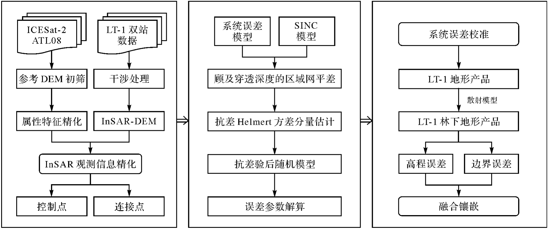
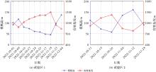
图2
LT-1数据配置"

表1
控制点和连接点的筛选法则"
| 数据集 | 数据来源 | 筛选法则 |
|---|---|---|
| 控制点 | ICESat-2 ATL08 | 1. 利用COP-DEM剔除粗差 |
| 2. 强波束 | ||
| 3. 云量小于20% | ||
| 4. 非InSAR几何畸变区 | ||
| 5. InSAR相干性大于第60百分位数 | ||
| 6. 与LT-1 DEM差分相互剔除粗差 | ||
| 连接点 | InSAR DEM | 1. 坡度小于30° |
| 2. 非InSAR几何畸变区 | ||
| 3. InSAR相干性大于第60百分位数 | ||
| 4. 连接点对差分相互剔除粗差 |
表2
FNF和全球DEM产品参数"
| 数据集 | 发布年份 | 水平基准 | 垂直基准 | 分辨率/m |
|---|---|---|---|---|
| COP-DEM | 2020 | WGS-84 | EGM2008 | 30 |
| SRTM V3 | 2013 | WGS-84 | EGM96 | 30 |
| AW3D V2.2 | 2019 | GRS80 | EGM96 | 30 |
| FNF | 2019 | WGS-84 | — | 50 |
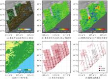
图3
试验区1试验结果"
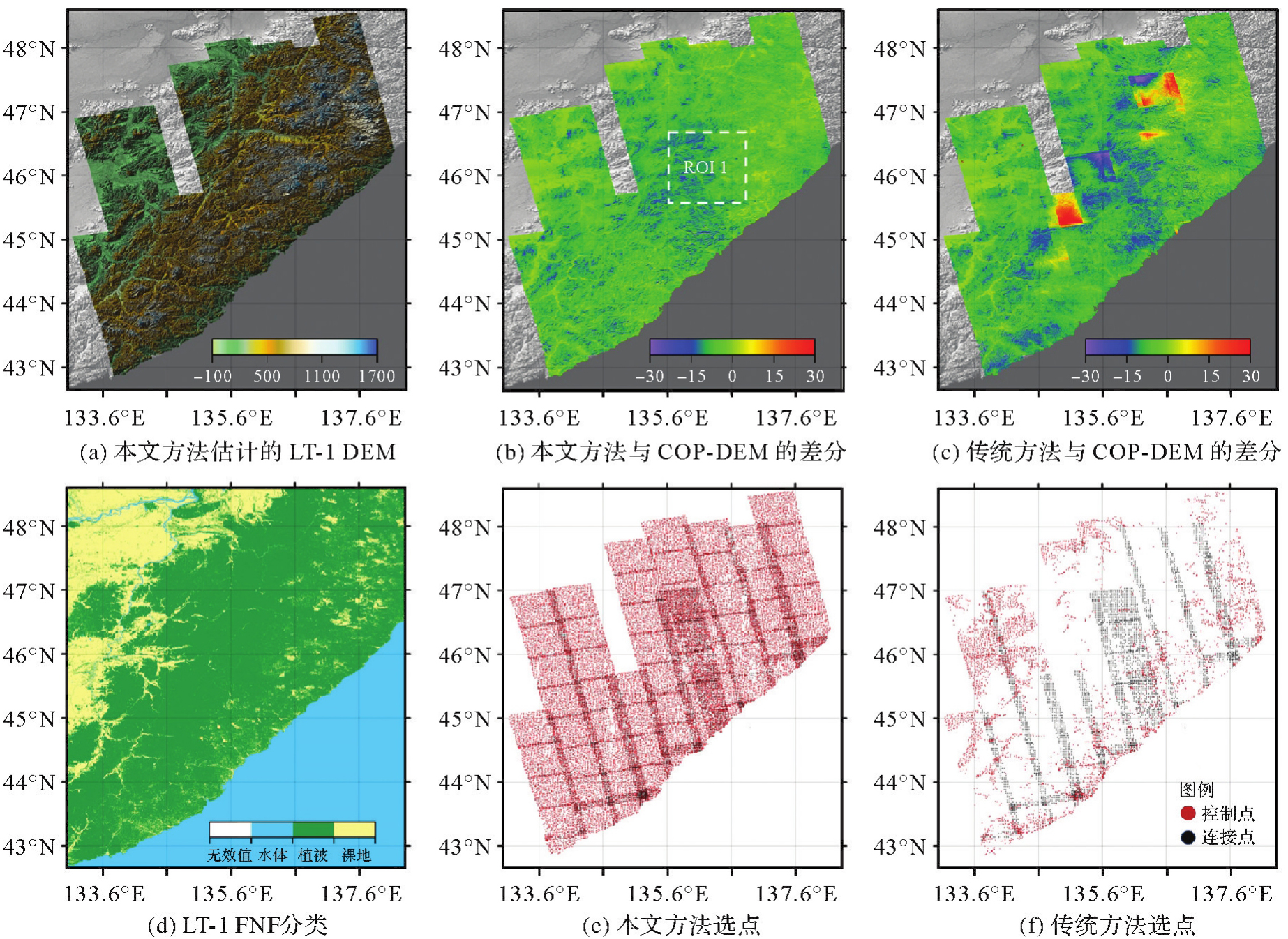
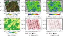
图4
试验区2试验结果"

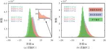
图5
测高精度统计"

表3
试验区1不同坡度下的地形精度对比"
| 地形产品 | (0°,5°] | (5°,10°] | (10°,15°] | (15°,20°] | (20°,90°] | |||||
|---|---|---|---|---|---|---|---|---|---|---|
| RMSE | MAE | RMSE | MAE | RMSE | MAE | RMSE | MAE | RMSE | MAE | |
| LT-1 DEM | 4.39 | 3.47 | 4.96 | 4.11 | 5.50 | 4.56 | 6.24 | 5.19 | 7.25 | 5.99 |
| 林下地形 | 2.26 | 1.70 | 2.79 | 2.13 | 3.41 | 2.63 | 4.20 | 3.24 | 5.45 | 4.20 |
| COP-DEM | 9.01 | 7.53 | 10.46 | 9.41 | 11.26 | 10.21 | 12.16 | 11.00 | 13.06 | 11.51 |
| SRTM | 5.40 | 4.39 | 6.48 | 5.51 | 7.54 | 6.44 | 8.84 | 7.49 | 10.43 | 8.68 |
| AW3D | 6.20 | 5.15 | 7.27 | 6.28 | 8.00 | 6.78 | 8.40 | 6.93 | 9.70 | 7.72 |
表4
试验区2不同坡度下的地形精度对比"
| 地形产品 | (0°,5°] | (5°,10°] | (10°,15°] | (15°,20°] | (20°,90°] | |||||
|---|---|---|---|---|---|---|---|---|---|---|
| RMSE | MAE | RMSE | MAE | RMSE | MAE | RMSE | MAE | RMSE | MAE | |
| LT-1 DEM | 2.31 | 1.56 | 3.13 | 2.32 | 4.00 | 3.07 | 5.15 | 4.05 | 6.67 | 5.30 |
| 林下地形 | 1.84 | 1.28 | 2.40 | 1.77 | 3.09 | 2.30 | 4.06 | 3.05 | 5.54 | 4.17 |
| COP-DEM | 4.91 | 3.28 | 6.68 | 5.21 | 7.83 | 6.42 | 9.10 | 7.59 | 10.53 | 8.84 |
| SRTM | 3.12 | 2.39 | 3.99 | 3.11 | 4.82 | 3.78 | 5.96 | 4.71 | 7.59 | 6.17 |
| AW3D | 3.83 | 2.88 | 5.14 | 4.06 | 6.23 | 4.97 | 7.08 | 5.56 | 9.32 | 7.22 |
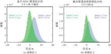
图6
森林区InSAR与LiDAR的测高匹配对比"
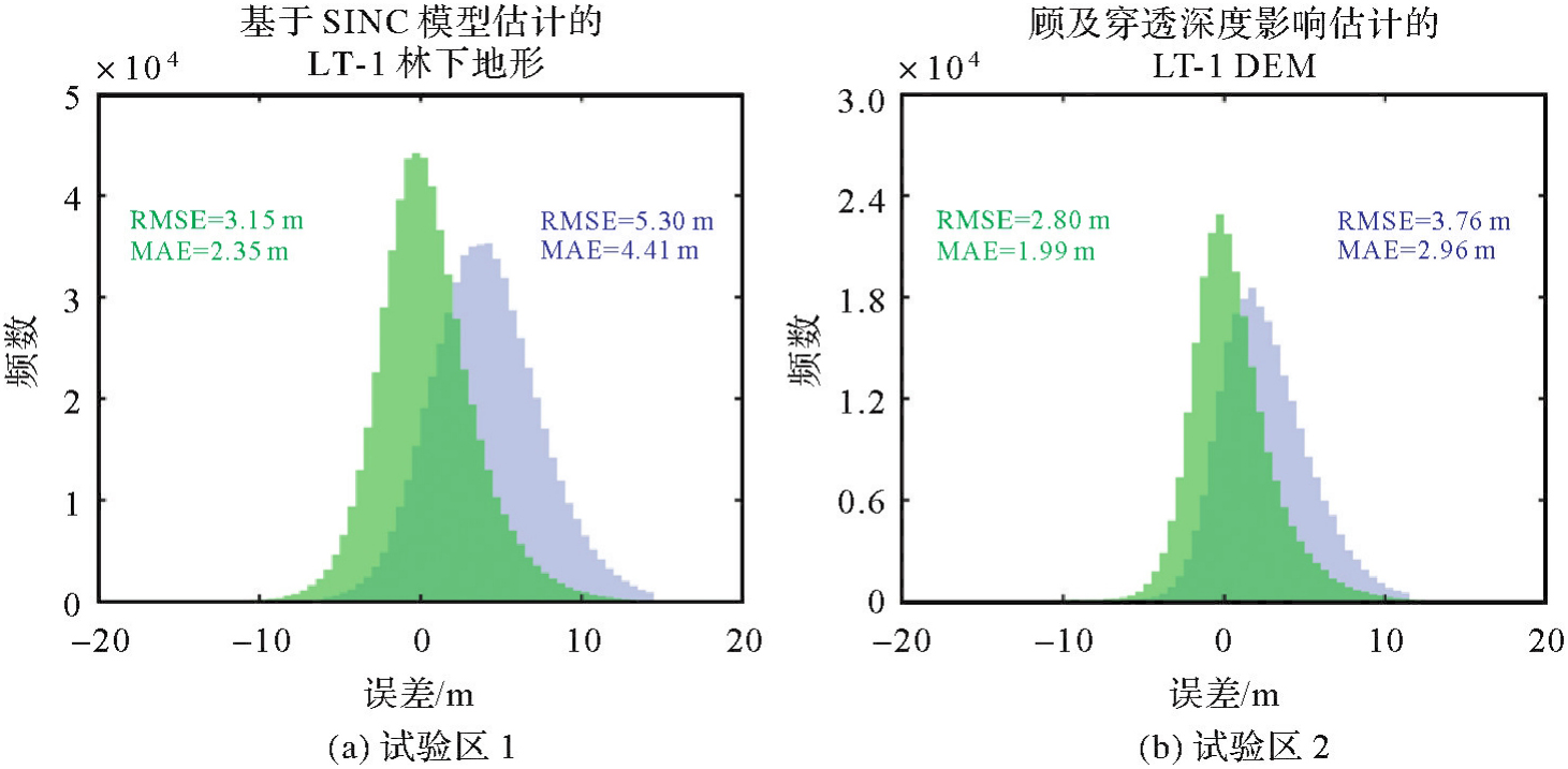
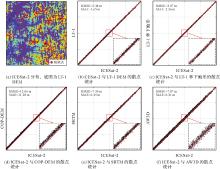
图7
ROI1不同波段森林穿透性的可视化分析"

表5
不同地形产品在不同坡度下的林区穿透率"
| 试验区 | 地形产品 | (0°,5°] | (5°,10°] | (10°,15°] | (15°,20°] | (20°,90°] |
|---|---|---|---|---|---|---|
| 1 | LT-1 DEM | 75.6 | 75.6 | 76.5 | 76.5 | 76.0 |
| LT-1林下地形 | 99.2 | 99.1 | 99.4 | 100.5 | 100.6 | |
| COP DEM | 51.7 | 52.0 | 48.9 | 50.9 | 51.6 | |
| SRTM | 68.4 | 68.2 | 67.5 | 61.5 | 58.9 | |
| AW3D | 67.8 | 67.6 | 66.7 | 64.7 | 63.2 | |
| 2 | LT-1 DEM | 77.4 | 77.8 | 76.3 | 74.2 | 76.7 |
| LT-1林下地形 | 99.5 | 99.0 | 98.9 | 99.7 | 100.2 | |
| COP DEM | 54.9 | 57.0 | 54.3 | 48.2 | 47.6 | |
| SRTM | 70.8 | 71.9 | 72.8 | 72.9 | 70.3 | |
| AW3D | 63.9 | 65.5 | 65.5 | 66.0 | 64.4 |
表6
SINC模型在不同森林类型下的拟合精度"
| 试验区 | 森林类型 | RMSE/m | MAE/m | 检核点数 |
|---|---|---|---|---|
| 1 | 落叶阔叶林 | 2.61 | 2.00 | 135217 |
| 常绿针叶林 | 2.69 | 2.09 | 49508 | |
| 落叶针叶林 | 2.47 | 1.91 | 37962 | |
| 2 | 落叶阔叶林 | 2.29 | 1.62 | 79289 |
| 常绿针叶林 | 2.73 | 2.02 | 2725 | |
| 落叶针叶林 | 2.33 | 1.68 | 7311 |
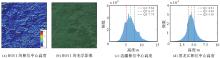
图8
SINC模型拟合的相位中心高度注:红线、绿线和蓝线分别代表Q1、Q2和Q3。"

| [1] | 朱建军, 付海强, 汪长城. InSAR林下地形测绘方法与研究进展[J]. 武汉大学学报(信息科学版), 2018, 43(12): 2030-2038. |
| ZHU Jianjun, FU Haiqiang, WANG Changcheng. Methods and research progress of underlying topography estimation over forest areas by InSAR[J]. Geomatics and Information Science of Wuhan University, 2018, 43(12): 2030-2038. | |
| [2] |
朱建军, 付海强, 汪长城. 极化干涉SAR地表覆盖层“穿透测绘”技术进展[J]. 测绘学报, 2022, 51(6): 983-995. DOI: .
doi: 10.11947/j.AGCS.2022.20220154 |
|
ZHU Jianjun, FU Haiqiang, WANG Changcheng. Research progress of "penetration mapping" of earth surface by PolInSAR[J]. Acta Geodaetica et Cartographica Sinica, 2022, 51(6): 983-995. DOI: .
doi: 10.11947/j.AGCS.2022.20220154 |
|
| [3] | 胡华参, 朱建军, 付海强, 等. 基于机器学习联合TanDEM-X InSAR和ICESat-2数据估计大范围林下地形[J]. 遥感学报, 2025, 29(1): 191-202. |
| HU Huacan, ZHU Jianjun, FU Haiqiang, et al. Large-scale sub-canopy topography estimation from TanDEM-X InSAR and ICESat-2 data using machine learning method[J]. National Remote Sensing Bulletin, 2025, 29(1): 191-202. | |
| [4] | 蔡士雪, 岳林蔚, 尹超, 等. 顾及林区植被穿透率的多源DEM数据精度评价[J]. 遥感学报, 2022, 26(11): 2268-2281. |
| CAI Shixue, YUE Linwei, YIN Chao, et al. Accuracy evaluation of multi-source DEM data based on the analysis of vegetation-induced penetration rate in the forest area[J]. National Remote Sensing Bulletin, 2022, 26(11): 2268-2281. | |
| [5] | LI Tao, TANG Xinming, ZHOU Xiaoqing, et al. LuTan-1 SAR main applications and products[C]//Proceedings of the 14th European Conference on Synthetic Aperture Radar. Leipzig: VDE, 2022: 1-4. |
| [6] | MU Minzheng, LI Zhiwei, XU Bing, et al. LT-1A/B satellite SAR geometric calibration and absolute location error analysis[J]. IEEE Journal of Selected Topics in Applied Earth Observations and Remote Sensing, 2024, 17: 16497-16510. |
| [7] | WESSEL B, GRUBER A, GONZALEZ J H, et al. TanDEM-X: DEM calibration concept[C]//Proceedings of 2008 IEEE International Geoscience and Remote Sensing Symposium. Boston: IEEE, 2008: 111-114. |
| [8] | WESSEL B, GRUBER A, HUBER M, et al. TanDEM-X: block adjustment of interferometric height models[C]//Proceedings of 2009 ISPRS Hannover Workshop. Berlin: DLR, 2009: 1-6. |
| [9] | LI Yi, FU Haiqiang, ZHU Jianjun, et al. A method for SRTM DEM elevation error correction in forested areas using ICESat-2 data and vegetation classification data[J]. Remote Sensing, 2022, 14(14): 3380. |
| [10] | FU Haiqiang, ZHU Jianjun, WANG Changcheng, et al. Underlying topography estimation over forest areas using single-baseline InSAR data[J]. IEEE Transactions on Geoscience and Remote Sensing, 2019, 57(5): 2876-2888. |
| [11] | GRUBER A, WESSEL B, HUBER M, et al. Operational TanDEM-X DEM calibration and first validation results[J]. ISPRS Journal of Photogrammetry and Remote Sensing, 2012, 73: 39-49. |
| [12] | HUBER M, WESSEL B, KOSMANN D, et al. Ensuring globally the TanDEM-X height accuracy: analysis of the reference data sets ICESat, SRTM and KGPS-tracks[C]//Proceedings of 2009 IEEE International Geoscience and Remote Sensing Symposium. Cape Town: IEEE, 2009: 769-772. |
| [13] | HUESO GONZALEZ J, BACHMANN M, SCHEIBER R, et al. Definition of ICESat selection criteria for their use as height references for TanDEM-X[J]. IEEE Transactions on Geoscience and Remote Sensing, 2010, 48(6): 2750-2757. |
| [14] |
张涛, 朱建军, 付海强, 等. 单基线TanDEM-X InSAR相干性反演森林高度[J]. 测绘学报, 2022, 51(9): 1931-1941. DOI: .
doi: 10.11947/j.AGCS.2022.20210298 |
|
ZHANG Tao, ZHU Jianjun, FU Haiqiang, et al. Forest height inversion with single-baseline TanDEM-X InSAR coherence[J]. Acta Geodaetica et Cartographica Sinica, 2022, 51(9): 1931-1941. DOI: .
doi: 10.11947/j.AGCS.2022.20210298 |
|
| [15] | LIU Liqun, LI Zhiwei, CAO Chenglong, et al. Robust helmert variance component estimation for InSAR DSM block adjustment[J]. IEEE Geoscience and Remote Sensing Letters, 2024, 21: 4011605. |
| [16] | GRUBER A, WESSEL B, MARTONE M, et al. The TanDEM-X DEM mosaicking: fusion of multiple acquisitions using InSAR quality parameters[J]. IEEE Journal of Selected Topics in Applied Earth Observations and Remote Sensing, 2016, 9(3): 1047-1057. |
| [17] | 李涛, 周晓青, 张祥, 等. 民用InSAR地形测绘卫星工程关键技术[J]. 测绘, 2023, 46(5): 199-205. |
| LI Tao, ZHOU Xiaoqing, ZHANG Xiang, et al. Key technologies of surveying and mapping InSAR satellites projects[J]. Surveying and Mapping, 2023, 46(5): 199-205. | |
| [18] | LIU Zhiwei, ZHU Jianjun, LOPEZ-SANCHEZ J M, et al. Simultaneous estimation of subcanopy topography and forest height with single-baseline single-polarization TanDEM-X interferometric data combined with ICESat-2 data[J]. IEEE Journal of Selected Topics in Applied Earth Observations and Remote Sensing, 2024, 17: 11598-11617. |
| [19] | RIZZOLI P, DELL'AMORE L, BUESO-BELLO J L, et al. On the derivation of volume decorrelation from TanDEM-X bistatic coherence[J]. IEEE Journal of Selected Topics in Applied Earth Observations and Remote Sensing, 2022, 15: 3504-3518. |
| [20] | WANG Huiqiang, FU Haiqiang, ZHU Jianjun, et al. Estimation of subcanopy topography based on single-baseline TanDEM-X InSAR data[J]. Journal of Geodesy, 2021, 95(7): 84. |
| [21] | GÓMEZ C, LOPEZ-SANCHEZ J M, ROMERO-PUIG N, et al. Canopy height estimation in Mediterranean forests of Spain with TanDEM-X data[J]. IEEE Journal of Selected Topics in Applied Earth Observations and Remote Sensing, 2021, 14: 2956-2970. |
| [22] | KRIEGER G, FIEDLER H, ZINK M, et al. The TanDEM-X mission: a satellite formation for high-resolution SAR interferometry[C]//Proceedings of 2007 European Radar Conference. Munich: IEEE, 2007: 83-86. |
| [23] | XU Bing, LIU Liqun, LI Zhiwei, et al. Design bistatic interferometric DEM generation algorithm and its theoretical accuracy analysis for LuTan-1 satellites[J]. Journal of Geodesy and Geoinformation Science, 2022, 5(1): 25-38. |
| [24] | NEUENSCHWANDER A, GUENTHER E, WHITE J C, et al. Validation of ICESat-2 terrain and canopy heights in boreal forests[J]. Remote Sensing of Environment, 2020, 251: 112110. |
| [25] | WU Kefu, FU Haiqiang, ZHU Jianjun, et al. InSAR-DEM block adjustment model for upcoming BIOMASS mission: considering atmospheric effects[J]. Remote Sensing, 2024, 16(10): 1764. |
| [26] | 王密, 韦钰, 杨博, 等. ICESat-2/ATLAS全球高程控制点提取与分析[J]. 武汉大学学报(信息科学版), 2021, 46(2): 184-192. |
| WANG Mi, WEI Yu, YANG Bo, et al. Extraction and analysis of global elevation control points from ICESat-2/ATLAS data[J]. Geomatics and Information Science of Wuhan University, 2021, 46(2): 184-192. | |
| [27] | WECKLICH C, MARTONE M, RIZZOLI P, et al. Production of a global forest/non-forest map utilizing TanDEM-X interferometric SAR data[C]//Proceedings of 2017 IEEE International Geoscience and Remote Sensing Symposium. Fort Worth: IEEE, 2017: 751-754. |
| [28] | CENCI L, GALLI M, PALUMBO G, et al. Describing the quality assessment workflow designed for DEM products distributed via the Copernicus programme. case study: the absolute vertical accuracy of the Copernicus DEM dataset in Spain[C]//Proceedings of 2021 IEEE International Geoscience and Remote Sensing Symposium. Brussels: IEEE, 2021: 6143-6146. |
| [29] | 唐新明, 李世金, 李涛, 等. 全球数字高程产品概述[J]. 遥感学报, 2021, 25(1): 167-181. |
| TANG Xinming, LI Shijin, LI Tao, et al. Review on global digital elevation products[J]. National Remote Sensing Bulletin, 2021, 25(1): 167-181. | |
| [30] | ZHANG Xiao, LIU Liangyun, CHEN Xidong, et al. GLC\_FCS30: global land-cover product with fine classification system at 30 m using time-series Landsat imagery[J]. Earth System Science Data, 2021, 13(6): 2753-2776. |
| [31] | OLESK A, VOORMANSIK K, VAIN A, et al. Seasonal differences in forest height estimation from interferometric TanDEM-X coherence data[J]. IEEE Journal of Selected Topics in Applied Earth Observations and Remote Sensing, 2015, 8(12): 5565-5572. |
| [32] | ZHANG Tao, FU Haiqiang, ZHU Jianjun, et al. Estimation of canopy height from a multi-SINC model in Mediterranean forest with single-baseline TanDEM-X InSAR data[J]. IEEE Journal of Selected Topics in Applied Earth Observations and Remote Sensing, 2024, 17: 5484-5499. |
| [33] | LU Hongliang, ZHANG Heng, FAN Huaitao, et al. Forest height retrieval using P-band airborne multi-baseline SAR data: a novel phase compensation method[J]. ISPRS Journal of Photogrammetry and Remote Sensing, 2021, 175: 99-118. |
| [34] | REIGBER A, MOREIRA A, PAPATHANASSIOU K P. First demonstration of airborne SAR tomography using multibaseline L-band data[C]//Proceedings of 1999 International Geoscience and Remote Sensing Symposium. Hamburg: IEEE, 1999: 44-46. |
| [1] | 黄文君, 孙群, 徐青, 范龙, 余岸竹, 张付兵. 融合频域特征与地形先验的全球沿海DEM超分辨率重建方法[J]. 测绘学报, 2025, 54(8): 1518-1531. |
| [2] | 朱珺, 彭葳, 付海强, 欧蔓, 雷缮诚, 张石平. 观测信息不足条件下TanDEM-X InSAR的大范围林下地形反演[J]. 测绘学报, 2024, 53(5): 959-966. |
| [3] | 朱珺, 朱凌杰, 邢学敏, 张锐, 鲍亮, 张腾飞, 鲍皓丹. 洞庭湖软土区域时序InSAR形变与环境物理参数联合估计方法[J]. 测绘学报, 2023, 52(12): 2127-2140. |
| [4] | 李欣, 蒋博洋, 汪韬阳, 张过, 崔浩, 程前. 面向高分三号全球正射影像生成的无控定位精度提升方法[J]. 测绘学报, 2023, 52(11): 1929-1940. |
| [5] | 张涛, 朱建军, 付海强, 汪长城. 单基线TanDEM-X InSAR相干性反演森林高度[J]. 测绘学报, 2022, 51(9): 1931-1941. |
| [6] | 张力, 刘玉轩, 孙洋杰, 蓝朝桢, 艾海滨, 樊仲藜. 数字航空摄影三维重建理论与技术发展综述[J]. 测绘学报, 2022, 51(7): 1437-1457. |
| [7] | 朱建军, 付海强, 汪长城. 极化干涉SAR地表覆盖层“穿透测绘”技术进展[J]. 测绘学报, 2022, 51(6): 983-995. |
| [8] | 朱建军, 胡俊, 李志伟, 孙倩, 郑万基. InSAR滑坡监测研究进展[J]. 测绘学报, 2022, 51(10): 2001-2019. |
| [9] | 伍洋, 张永生, 李凯, 于英, 赖广陵. 附加视线向量修正的卫星影像区域网平差[J]. 测绘学报, 2021, 50(1): 85-96. |
| [10] | 姚树一, 张燕海, 杨可明, 石晓宇, 王剑. 注浆采区地表形变时空演化SMD-InSAR监测分析法[J]. 测绘学报, 2020, 49(7): 893-906. |
| [11] | 詹总谦, 胡孟琦, 满益云. 多尺度区域生长点云滤波地表拟合法[J]. 测绘学报, 2020, 49(6): 757-766. |
| [12] | 韩杰, 陶醉, 谢勇, 刘其悦, 石宏斌. 顾及多积分时间特性的GF-4卫星PMS传感器交叉辐射定标[J]. 测绘学报, 2020, 49(10): 1311-1320. |
| [13] | 曹辉, 陶鹏杰, 李海鸿, 张祖勋. DEM约束的卫星影像定位法[J]. 测绘学报, 2020, 49(1): 79-91. |
| [14] | 胡翰, 丁雨淋, 朱庆, 蒋捷, 文学虎, 张力, 唐伟, 阳俊, 钟若飞. 面向全球DEM生产的点云智能滤波与DEM泊松编辑方法[J]. 测绘学报, 2019, 48(3): 374-383. |
| [15] | 夏誉玲, 李小娟, 王涛. 基于数字高程模型的混合流向算法[J]. 测绘学报, 2018, 47(5): 683-691. |
| 阅读次数 | ||||||
|
全文 |
|
|||||
|
摘要 |
|
|||||