


测绘学报 ›› 2025, Vol. 54 ›› Issue (11): 1968-1979.doi: 10.11947/j.AGCS.2025.20250231
顾元元1,2( ), 姚旭3, 安璐1,2(), 乔刚1,2, 郝彤1,2
收稿日期:2025-06-05
修回日期:2025-11-03
出版日期:2025-12-15
发布日期:2025-12-15
通讯作者:
安璐
E-mail:yuan1@tongji.edu.cn;anlu2021@tongji.edu.cn
作者简介:顾元元(1996—),男,博士生,研究方向为GNSS数据处理、卫星激光测高数据验证与应用。E-mail:yuan1@tongji.edu.cn
基金资助:
Yuanyuan GU1,2(), Xu YAO3, Lu AN1,2(), Gang QIAO1,2, Tong HAO1,2
Received:2025-06-05
Revised:2025-11-03
Online:2025-12-15
Published:2025-12-15
Contact:
Lu AN
E-mail:yuan1@tongji.edu.cn;anlu2021@tongji.edu.cn
About author:GU Yuanyuan (1996—), male, PhD candidate, majors in GNSS data processing as well as the validation and application of satellite laser altimetry data. E-mail: yuan1@tongji.edu.cn
Supported by:摘要:
中国南极内陆科考路线是一条相对固定的路线,自沿海的中山站出发,途经泰山站,延伸至位于冰穹A点附近的昆仑站。全线复杂多变的地形特征,为每年常态化科考任务的组织与实施带来巨大挑战,因此亟须对科考沿线地形和雪层特性进行深入研究,以保障科考队安全高效行进和常态化科考业务的开展。本文基于中国第39次南极科考期间采集的1250 km高精度动态车载GNSS测线,根据行驶里程划分统计单元,分别计算各单元内累计垂直位移、最大垂直位移、垂直位移大于30 cm的发生频率,以及沿线坡度。通过上述指标,全面评估了科考沿线冰盖表面平整度,有效识别雪丘、雪垄、风蚀槽等地形障碍密集分布的关键路段,并进一步分析雪地车累计垂直位移量分布趋势与冰盖表面三维地形、表面风向风速之间的相互关系。数据结果表明全线最颠簸的路段位于距离出发基地175~500 km与860~1180 km的位置。研究结果可为中国后续的内陆考察方案制定,包括重型装备运输、物资配载、行进速度规划等提供重要参考。
中图分类号:
顾元元, 姚旭, 安璐, 乔刚, 郝彤. 基于高精度动态GNSS测线的中国南极内陆科考路线平整度分析与评估[J]. 测绘学报, 2025, 54(11): 1968-1979.
Yuanyuan GU, Xu YAO, Lu AN, Gang QIAO, Tong HAO. Analysis and evaluation of route roughness along the CHINARE inland traverse based on high-precision dynamic GNSS data[J]. Acta Geodaetica et Cartographica Sinica, 2025, 54(11): 1968-1979.
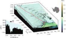
图1
中国第39次南极内陆考察沿线三维地形注:红线源自GNSS手簿测量路线;冰盖和基岩厚度数据源于Bedmachine V3。"
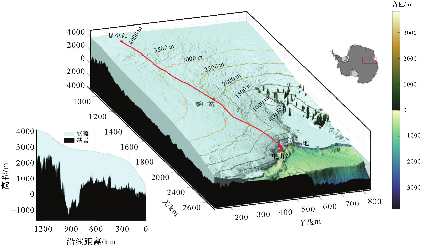
表1
基准站工作时长统计"
| 基准站 | 观测天数/d |
|---|---|
| Base1 | 7 |
| Base2 | 4 |
| Base3 | 5 |
| Base4 | 5 |
| Base5 | 4 |
| Base6 | 5 |
| Base7 | 4 |
图2
GNSS移动站路线和7个基准站沿线分布注:背景为LIMA(Landsat image mosaic of Antarctica)[24]。"

图3
CHINARE内陆科考沿线不同地形平整度特征"

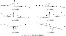
图4
不同地形特征条件下提取垂直位移量d1-d6"
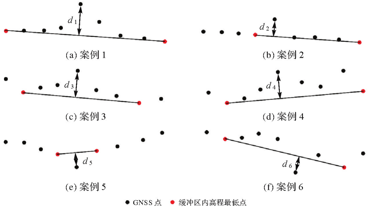
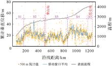
图5
雪地车累积垂直位移分布注:黄点为雪地车垂直位移分布,蓝线为其10 km移动平均值;黑线为GNSS解算的沿线精确地表高程。"

图6
雪地车最大垂直位移分布注:黄点为雪地车最大垂直位移统计分布,蓝线为其移动窗口平均线。"

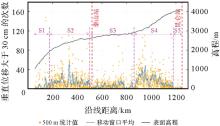
图7
雪地车垂直位移大于30 cm次数分布注:黄点为雪地车垂直位移超过30 cm的次数分布,蓝线为其移动窗口平均线。"
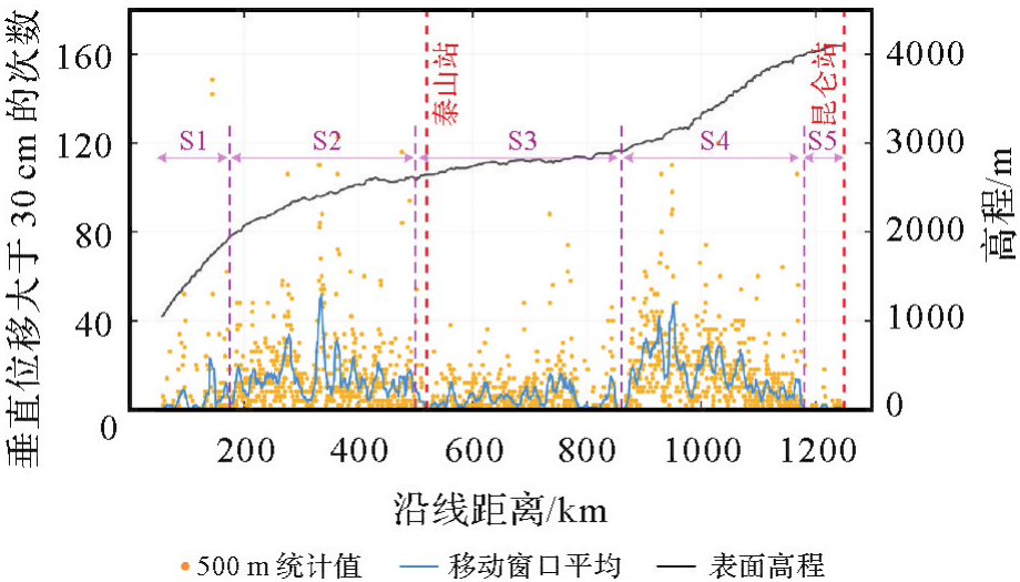
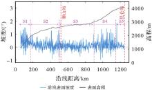
图8
沿线的表面坡度与高程分布"

表2
沿线不同分段统计指标"
| 路段(距离范围) | 垂直位移/(m/km) | 最大垂直位移/m | 超过30 cm发生频率/(次/km) | 平均坡度/(°) |
|---|---|---|---|---|
| S1(55~175 km) | 12.26 | 0.29 | 4.92 | 0.42 |
| S2(175~500 km) | 23.00 | 0.42 | 14.34 | 0.11 |
| S3(500~860 km) | 16.11 | 0.32 | 5.29 | 0.07 |
| S4(860~1180 km) | 25.40 | 0.41 | 16.35 | 0.21 |
| S5(1180~1250 km) | 17.58 | 0.26 | 0.55 | 0.07 |
| 全程平均 | 20.21 | 0.37 | 10.45 | 0.15 |
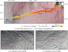
图9
CHINARE内陆沿线2018—2022年表面平均风速风向分布与S2、S4区间内Landsat-8影像"

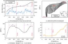
图10
CHINARE内陆沿线表面平整度与三维地形、风向及FAC分布"

| [1] | RIGNOT E, MOUGINOT J, SCHEUCHL B, et al. Four decades of Antarctic ice sheet mass balance from 1979—2017[J]. Proceedings of the National Academy of Sciences, 2019, 116(4): 1095-1103. |
| [2] | SHEPHERD A, IVINS E, RIGNOT E, et al. Mass balance of the Greenland ice sheet from 1992 to 2018[J]. Nature, 2019, 579(7798): 233-239. |
| [3] | CHRISTNER B C, PRISCU J C, ACHBERGER A M, et al. A microbial ecosystem beneath the West Antarctic ice sheet[J]. Nature, 2014, 512(7514): 310-313. |
| [4] | SIEGERT M J, PRISCU J C, ALEKHINA I A, et al. Antarctic subglacial lake exploration: first results and future plans[J]. Philosophical Transactions of the Royal Society A: Mathematical, Physical and Engineering Sciences, 2016, 374(2059): 20140466. |
| [5] | RIGNOT E, MOUGINOT J, SCHEUCHL B. Ice flow of the Antarctic ice sheet[J]. Science, 2011, 333(6048): 1427-1430. |
| [6] | CSATHO B M, SCHENK A F, VAN DER VEEN C J, et al. Laser altimetry reveals complex pattern of Greenland ice sheet dynamics[J]. Proceedings of the National Academy of Sciences, 2014, 111(52): 18478-18483. |
| [7] | TIAN Biao, DING Minghu, PUTERO D, et al. Multi-year variation of near-surface ozone at Zhongshan station, Antarctica[J]. Environmental Research Letters, 2022, 17(4): 044003. |
| [8] | DING Minghu, ZOU Xiaowei, SUN Qizhen, et al. The PANDA automatic weather station network between the coast and Dome A, East Antarctica[J]. Earth System Science Data, 2022, 14(11): 5019-5035. |
| [9] | MA Bin, SHANG Zhaohui, HU Yi, et al. Night-time measurements of astronomical seeing at Dome A in Antarctica[J]. Nature, 2020, 583(7818): 771-774. |
| [10] | MA Bin, HU Yi, SHANG Zhaohui, et al. Automation of the AST3 optical sky survey from Dome A, Antarctica[J]. Monthly Notices of the Royal Astronomical Society, 2020, 496(3): 2768-2775. |
| [11] | DONG Sheng, FU Lei, TANG Xueyuan, et al. Deep clustering in subglacial radar reflectance reveals subglacial lakes[J]. The Cryosphere, 2024, 18(3): 1241-1257. |
| [12] | DING Minghu, XIAO Cunde, LI Chuanjin, et al. Surface mass balance and its climate significance from the coast to Dome A, East Antarctica[J]. Science China Earth Sciences, 2015, 58(10): 1787-1797. |
| [13] | BRUNT K M, NEUMANN T A, SMITH B E. Assessment of ICESat-2 ice sheet surface heights, based on comparisons over the interior of the Antarctic ice sheet[J]. Geophysical Research Letters, 2019, 46(22): 13072-13078. |
| [14] | BRUNT K M, SMITH B E, SUTTERLEY T C, et al. Comparisons of satellite and airborne altimetry with ground-based data from the interior of the Antarctic ice sheet[J]. Geophysical Research Letters, 2021, 48(2): e2020GL090572. |
| [15] | BRUNT K M, NEUMANN T A, LARSEN C F. Assessment of altimetry using ground-based GPS data from the 88S Traverse, Antarctica, in support of ICESat-2[J]. The Cryosphere, 2019, 13(2): 579-590. |
| [16] | SCHRÖDER L, RICHTER A, FEDOROV D V, et al. Validation of satellite altimetry by kinematic GNSS in central East Antarctica[J]. The Cryosphere, 2017, 11(3): 1111-1130. |
| [17] | KOHLER J, NEUMANN T A, ROBBINS J W, et al. ICESat elevations in Antarctica along the 2007-09 Norway-USA traverse: validation with ground-based GPS[J]. IEEE Transactions on Geoscience and Remote Sensing, 2013, 51(3): 1578-1587. |
| [18] | LI Rongxing, LI Hongwei, HAO Tong, et al. Assessment of ICESat-2 ice surface elevations over the Chinese Antarctic research expedition (CHINARE) route, East Antarctica, based on coordinated multi-sensor observations[J]. The Cryosphere, 2021, 15(7): 3083-3099. |
| [19] | HOWAT I M, PORTER C, SMITH B E, et al. The reference elevation model of Antarctica[J]. The Cryosphere, 2019, 13(2): 665-674. |
| [20] | MARKUS T, NEUMANN T, MARTINO A, et al. The ice, cloud, and land elevation satellite-2 (ICESat-2): science requirements, concept, and implementation[J]. Remote Sensing of Environment, 2017, 190: 260-273. |
| [21] | MORLIGHEM M, WILLIAMS C N, RIGNOT E, et al. BedMachine v3: complete bed topography and ocean bathymetry mapping of Greenland from multibeam echo sounding combined with mass conservation[J]. Geophysical Research Letters, 2017, 44(21): 11051-11061. |
| [22] | MORLIGHEM M, RIGNOT E, BINDER T, et al. Deep glacial troughs and stabilizing ridges unveiled beneath the margins of the Antarctic ice sheet[J]. Nature Geoscience, 2019, 13(2): 132-137. |
| [23] | GREENE C A, GWYTHER D E, BLANKENSHIP D D. Antarctic mapping tools for Matlab[J]. Computers & Geosciences, 2017, 104: 151-157. |
| [24] | BINDSCHADLER R, VORNBERGER P, FLEMING A, et al. The Landsat image mosaic of Antarctica[J]. Remote Sensing of Environment, 2008, 112(12): 4214-4226. |
| [25] | LI Bofeng, ZANG Nan, GE Haibo, et al. Single-frequency PPP models: analytical and numerical comparison[J]. Journal of Geodesy, 2019, 93(12): 2499-2514. |
| [26] | TAKASU T, YASUDA A. Development of the low-cost RTK-GPS receiver with an open source program package RTKLIB[C]//Proceedings of 2009 International Symposium on GPS/GNSS. Jeju: [s.n.], 2009: 4-6. |
| [27] | PIRTI A, YUCEL A M. Evalution of the accuracy and performance of multi-GNSS (MGEX) positioning for long baselines by using different software[J]. Journal of Geodesy and Geoinformation Science, 2023, 6(4): 79-92. |
| [28] | ASTM International. Standard practice for computing international roughness index of roads from longitudinal profile measurements: ASTM E1926-08(2021)[S]. West Conshohocken: [s.n.], 2021. |
| [29] | 李清泉, 毛庆洲. 道路/轨道动态精密测量进展[J]. 测绘学报, 2017, 46(10): 1734-1741. DOI: 10.11947/j.AGCS.2017.20170323. |
| LI Qingquan, MAO Qingzhou. Progress on dynamic and precise engineering surveying for pavement and track[J]. Acta Geodaetica et Cartographica Sinica, 2017, 46(10): 1734-1741. DOI: 10.11947/j.AGCS.2017.20170323. | |
| [30] | 蔚晓丹. 国际平整度指数IRI作为路面平整度评价指标的研究[J]. 公路交通科技, 1999, 16(S1): 9-13. |
| YU Xiaodan. Research on the international roughness index (IRI) as the pavement roughness index[J]. Journal of Highway and Transportation Research and Development, 1999, 16(S1): 9-13. | |
| [31] | 周晓青, 孙立军, 颜利. 路面平整度评价发展及趋势[J]. 公路交通科技, 2005, 22(10): 18-22. |
| ZHOU Xiaoqing, SUN Lijun, YAN Li. Research progress and trend of pavement roughness inidces[J]. Journal of Highway and Transportation Research and Development, 2005, 22(10): 18-22. | |
| [32] | DAS I, BELL R E, SCAMBOS T A, et al. Influence of persistent wind scour on the surface mass balance of Antarctica[J]. Nature Geoscience, 2013, 6(5): 367-371. |
| [33] | SCAMBOS T A, FREZZOTTI M, HARAN T, et al. Extent of low-accumulation “wind glaze” areas on the East Antarctic plateau: implications for continental ice mass balance[J]. Journal of Glaciology, 2012, 58(210): 633-647. |
| [34] | 苏小岗, 孙波, 刘春, 等. 南极冰盖表面微地貌研究进展与展望[J]. 极地研究, 2016, 28(4): 442-450. |
| SU Xiaogang, SUN Bo, LIU Chun, et al. The research progress and prospect of microrelief on the Antarctic ice sheet surface[J]. Chinese Journal of Polar Research, 2016, 28(4): 442-450. | |
| [35] | ZHANG Shengkai, DONGCHEN E, WANG Zemin, et al. Ice velocity from static GPS observations along the transect from Zhongshan station to Dome A, East Antarctica[J]. Annals of Glaciology, 2008, 48: 113-118. |
| [36] | FREZZOTTI M, GANDOLFI S, MARCA F L, et al. Snow dunes and glazed surfaces in Antarctica: new field and remote-sensing data[J]. Annals of Glaciology, 2002, 34: 81-88. |
| [37] | PARISH T R, BROMWICH D H. The surface windfield over the Antarctic ice sheets[J]. Nature, 1987, 328(6125): 51-54. |
| [38] | PARISH T R, BROMWICH D H. Continental-scale simulation of the Antarctic katabatic wind regime[J]. Journal of Climate, 1991, 4(2): 135-146. |
| [39] | 王艳华, 王富富, 张国苗, 等. 基于文丘里效应的低速风聚风装置结构设计与优化[J]. 机械设计, 2024, 41(7): 53-60. |
| WANG Yanhua, WANG Fufu, ZHANG Guomiao, et al. Structural design and optimization of breeze air collector based on Venturi effect[J]. Journal of Machine Design, 2024, 41(7): 53-60. | |
| [40] | BROMWICH D H. Satellite analyses of Antarctic katabatic wind behavior[J]. Bulletin of the American Meteorological Society, 1989, 70(7): 738-749. |
| [41] | LEHNING M, LÖWE H, RYSER M, et al. Inhomogeneous precipitation distribution and snow transport in steep terrain[J]. Water Resources Research, 2008, 44(7):: 278-284. |
| [42] | MOTT R, SCHIRMER M, BAVAY M, et al. Understanding snow-transport processes shaping the mountain snow-cover[J]. The Cryosphere, 2010, 4(4): 545-559. |
| [43] | FREZZOTTI M, POURCHET M, FLORA O, et al. Spatial and temporal variability of snow accumulation in East Antarctica from traverse data[J]. Journal of Glaciology, 2005, 51(172): 113-124. |
| [44] | HERSBACH H, BELL B, BERRISFORD P, et al. ERA5 monthly averaged data on single levels from 1940 to present[DB]. Bracknell: Copernicus Climate Change Service Climate Data Store, 2023. |
| [45] | MEDLEY B, NEUMANN T A, ZWALLY H J, et al. Simulations of firn processes over the Greenland and Antarctic ice sheets: 1980—2021[J]. The Cryosphere, 2022, 16(10): 3971-4011. |
| [46] | VAN DEN BROEKE M R, VAN LIPZIG N P M. Factors controlling the near-surface wind field in Antarctica[J]. Monthly Weather Review, 2003, 131(4): 733-743. |
| [47] | PARISH T R, CASSANO J J. The role of katabatic winds on the Antarctic surface wind regime[J]. Monthly Weather Review, 2003, 131(2): 317. |
| [48] | FREZZOTTI M, GANDOLFI S, URBINI S. Snow megadunes in Antarctica: sedimentary structure and genesis[J]. Journal of Geophysical Research: Atmospheres, 2002, 107(D18): ACL1-1-ACL1-12. |
| [1] | 布金伟, 刘淑慧, 徐顺双, 向彤粟, 汪秋兰, 籍超颖, 左小清. 星载GNSS-R全球海浪波周期估计的经验模型构建[J]. 测绘学报, 2026, 55(4): 684-697. |
| [2] | 吴汤婷, 罗馨语, 卢立果, 刘站科, 超能芳. 基于GNSS和GRACE/GRACE-FO的陕甘宁地区水资源与水文干旱特征时空变化评价[J]. 测绘学报, 2026, 55(3): 439-450. |
| [3] | 马中民, 张双成, 周昕, 刘奇, 刘宁, 王恒利. 顾及地表反射率不确定性的风云三号GNSS-R洪涝监测方法:以8·2广东极端暴雨灾害为例[J]. 测绘学报, 2026, 55(3): 451-464. |
| [4] | 严清赟, 郭紫璇, 潘元进, 贾燕, 金双根. GNSS-R陆表反射率空间分异驱动因子定量分析与分区模式[J]. 测绘学报, 2026, 55(2): 315-327. |
| [5] | 赵庆志, 蒋朵朵, 姚宜斌, 马智, 马永杰, 李浩杰, 薛瑞瑞. 一种GNSS卫星信号自适应优选的水汽层析方法[J]. 测绘学报, 2026, 55(1): 25-35. |
| [6] | 余德荧, 李厚朴, 刘一, 武曙光, 李得宴, 李明超, 李文魁, 边少锋. 基于DBSCAN的多粗差识别RAIM算法[J]. 测绘学报, 2026, 55(1): 59-72. |
| [7] | 程栋梁, 陈灵秋, 黄志勇, 乔书波, 王丹丹, 闫亚明. 基于COATS的多模多频iGNSS-R测高性能评估[J]. 测绘学报, 2026, 55(1): 73-89. |
| [8] | 罗亚荣, 卢文韬, 郭迟, 刘经南. GNSS/INS组合导航左手对称性等变滤波模型及算法[J]. 测绘学报, 2025, 54(8): 1389-1403. |
| [9] | 陈洋溢, 郑凯, 张小红, 吴明魁, 王鹏旭, 付文举, 刘克中. GPS/Galileo/BDS重叠频率多路径误差分析及建模[J]. 测绘学报, 2025, 54(8): 1427-1438. |
| [10] | 李建章, 闫浩文, 杨维芳, 苏小宁. GNSS伪三角高程测量方法[J]. 测绘学报, 2025, 54(7): 1170-1177. |
| [11] | 王潜心, 胡超, 程彤. 基于GNSS钟差参数先验信息的超快速轨道钟差估计方法[J]. 测绘学报, 2025, 54(6): 982-994. |
| [12] | 沈洋, 李广云, 陈明剑, 李林阳, 施星宇, 蔡巍, 郝卫峰. 基于风云三号TEC的极区GNSS电离层模型精度评估[J]. 测绘学报, 2025, 54(6): 995-1008. |
| [13] | 胡顺强, 陈克杰, 贺小星, 朱海, 王坦. 环境负载对川滇地区GNSS观测站三维坐标时间序列非线性变化的影响[J]. 测绘学报, 2025, 54(5): 805-818. |
| [14] | 杨文涛, 郭斐, 张小红, 张治宇, 朱逸凡, 李政, 吴子恒. 利用GNSS反射计和SMAP辐射计反演青藏高原土壤湿度和冻融状态[J]. 测绘学报, 2025, 54(4): 725-735. |
| [15] | 刘学习, 朱守庆, 陈国, 张克非, 郑南山, 刘婧璇. 基于全球统一坐标框架的GNSS精密轨道与钟差产品一致性分析[J]. 测绘学报, 2025, 54(3): 432-447. |
| 阅读次数 | ||||||
|
全文 |
|
|||||
|
摘要 |
|
|||||