


测绘学报 ›› 2025, Vol. 54 ›› Issue (12): 2116-2128.doi: 10.11947/j.AGCS.2025.20250245
李博峰( ), 陈龙, 袁雷童
收稿日期:2025-06-13
修回日期:2025-12-25
出版日期:2026-01-15
发布日期:2026-01-15
作者简介:李博峰(1983—),男,博士,教授,研究方向为卫星大地测量。 E-mail:bofeng_li@tongji.edu.cn
基金资助:
Bofeng LI(), Long CHEN, Leitong YUAN
Received:2025-06-13
Revised:2025-12-25
Online:2026-01-15
Published:2026-01-15
About author:LI Bofeng (1983—), male, PhD, professor, majors in satellite geodesy. E-mail: bofeng_li@tongji.edu.cn
Supported by:摘要:
GNSS变形监测应用面临监测场景复杂和监测设备低成本两大趋势。GNSS高精度监测技术依赖高效可靠的模糊度固定,但受部分遮挡、干扰频繁、监测基线长等复杂条件影响,其模糊度解算能力和变形监测服务性能显著下降。本文充分挖掘区域多监测站的时空关联特性,提出一种GNSS多基线联合简便解算的变形监测方法;推导了多基线联合解算模型的解析解,分析了浮点解精度随监测站数量增加的改善效果;设计了复杂遮挡环境的区域监测试验,通过理论和实际指标验证了本文方法的有效性。杭州湾跨海大桥监测试验结果表明,本文方法可有效提升复杂场景下的监测效果,其收敛速度更快、监测距离更长且模型参数轻量化,具有较好的拓展性和应用前景。
中图分类号:
李博峰, 陈龙, 袁雷童. GNSS多基线联合解算的高精度变形监测方法[J]. 测绘学报, 2025, 54(12): 2116-2128.
Bofeng LI, Long CHEN, Leitong YUAN. A high-precision deformation monitoring method with GNSS multi-baseline solutions[J]. Acta Geodaetica et Cartographica Sinica, 2025, 54(12): 2116-2128.
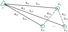
图1
多基线联合解算"
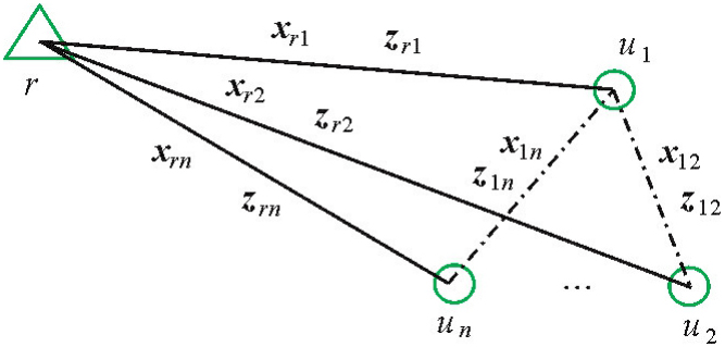
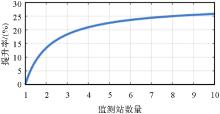
图2
模糊度浮点解精度提升率随监测站数量变化"
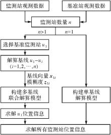
图3
GNSS多基线联合解算流程"

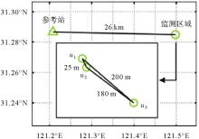
图4
模拟监测试验站点分布"
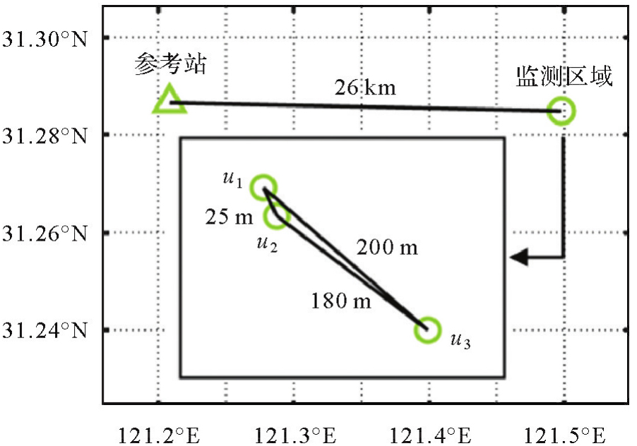
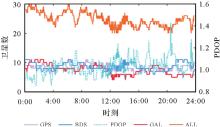
图5
模拟监测试验可用卫星数与PDOP时间序列"


图6
ADOP时间序列"
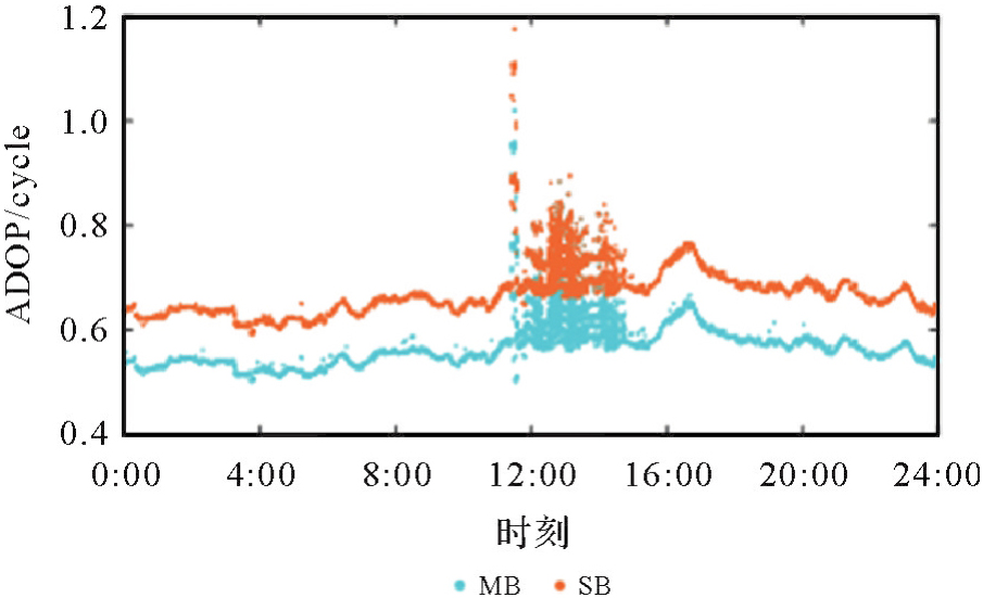

图7
平均Bootstrapping成功率"
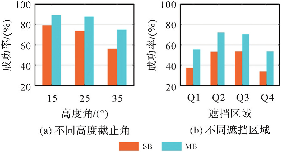
表1
监测精度STD统计"
| 监测站 | 单/多基线解算 | 无遮挡 | Q1 | Q2 | Q3 | Q4 | ||||||||||
|---|---|---|---|---|---|---|---|---|---|---|---|---|---|---|---|---|
| E | N | U | E | N | U | E | N | U | E | N | U | E | N | U | ||
| u1 | SB | 0.8 | 0.6 | 2.7 | 1.0 | 0.7 | 2.6 | 0.8 | 0.7 | 2.7 | 0.8 | 0.9 | 2.6 | 1.0 | 0.7 | 3.3 |
| MB | 0.7 | 0.5 | 2.7 | 1.0 | 0.7 | 2.0 | 0.7 | 0.7 | 2.7 | 0.7 | 0.7 | 2.7 | 0.5 | 0.6 | 2.9 | |
| u2 | SB | 0.5 | 0.7 | 3.0 | 0.9 | 0.6 | 2.9 | 0.5 | 0.7 | 3.2 | 0.5 | 1.0 | 3.3 | 0.9 | 1.2 | 4.4 |
| MB | 0.5 | 0.7 | 3.1 | 1.2 | 0.7 | 3.1 | 0.5 | 0.8 | 2.9 | 0.5 | 1.0 | 3.1 | 0.7 | 1.5 | 3.8 | |
| u3 | SB | 1.0 | 0.8 | 3.9 | 3.3 | 1.1 | 4.1 | 1.2 | 1.3 | 4.1 | 1.3 | 1.4 | 4.0 | 1.4 | 0.7 | 6.7 |
| MB | 1.0 | 0.7 | 3.5 | 3.3 | 1.5 | 2.7 | 0.9 | 1.1 | 3.5 | 1.2 | 1.3 | 3.2 | 1.5 | 0.9 | 5.0 | |
图8
平均模糊度固定率"

表2
第1种TTFF平均值"
| 单/多基线解算 | 高度角 | 遮挡区域 | |||||
|---|---|---|---|---|---|---|---|
| 15° | 25° | 35° | Q1 | Q2 | Q3 | Q4 | |
| SB | 55.85 | 68.27 | 91.14 | 55.85 | 47.85 | 49.26 | 62.41 |
| MB | 22.75 | 23.67 | 37.68 | 46.07 | 37.98 | 38.71 | 50.14 |
表3
第2种TTFF平均值"
| 单/多基线解算 | ratio | 高度角 | 遮挡区域 | |||||||
|---|---|---|---|---|---|---|---|---|---|---|
| 2 | 3 | 4 | 15° | 25° | 35° | Q1 | Q2 | Q3 | Q4 | |
| SB | 196.58 | 209.67 | 210.87 | 165.89 | 193.06 | 273.10 | 323.04 | 249.04 | 284.13 | 341.34 |
| MB | 143.31 | 156.65 | 158.97 | 117.26 | 147.88 | 208.39 | 242.16 | 193.04 | 217.48 | 244.58 |
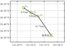
图9
杭州湾跨海大桥监测试验站点分布"
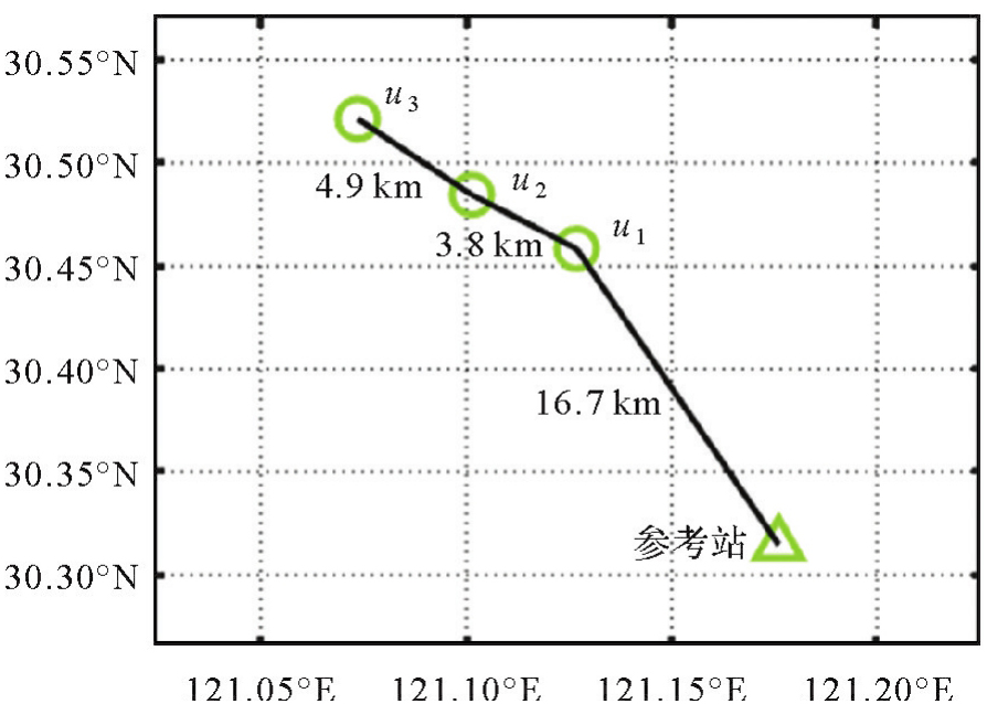
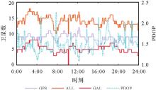
图10
杭州湾跨海大桥监测试验卫星数与PDOP"
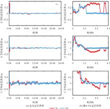
图11
u1定位误差时间序列"
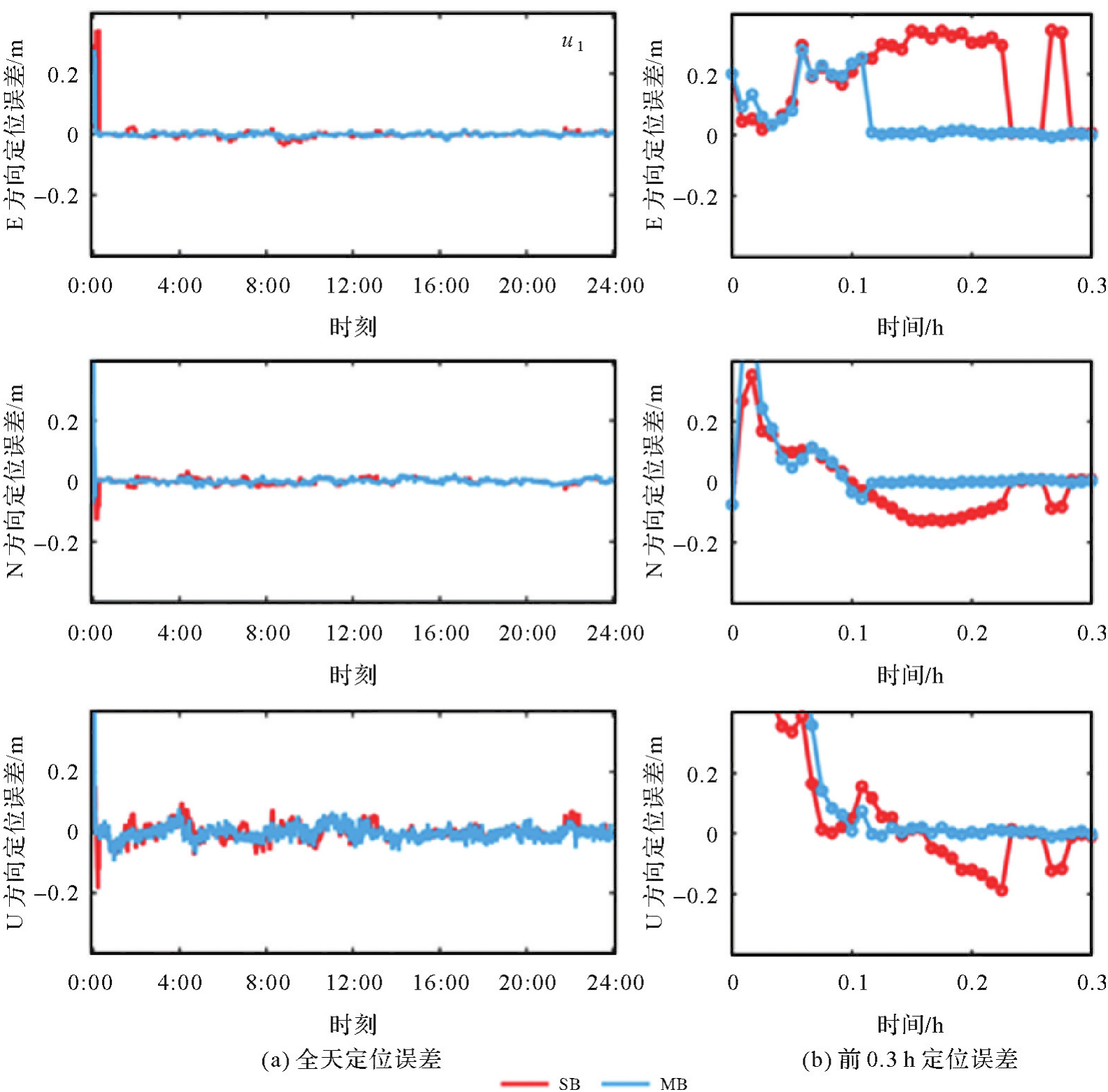
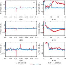
图12
u2定位误差时间序列"

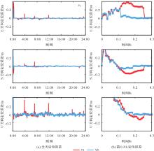
图13
u3定位误差时间序列"

表4
经验成功率"
| 单/多基线解算 | u1 | u2 | u3 |
|---|---|---|---|
| SB | 94.6 | 96.8 | 93.9 |
| MB | 98.6 | 98.6 | 98.5 |
表5
动态定位误差统计"
| 监测站 | 单/多基线解算 | STD | ||
|---|---|---|---|---|
| E | N | U | ||
| u1 | SB | 0.81 | 0.88 | 2.47 |
| MB | 0.65 | 0.78 | 2.09 | |
| u2 | SB | 0.76 | 0.93 | 2.77 |
| MB | 0.63 | 0.75 | 2.32 | |
| u3 | SB | 0.77 | 0.83 | 2.47 |
| MB | 0.64 | 0.75 | 2.08 | |
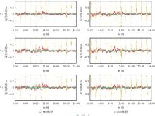
图14
重收敛定位误差时间序列"
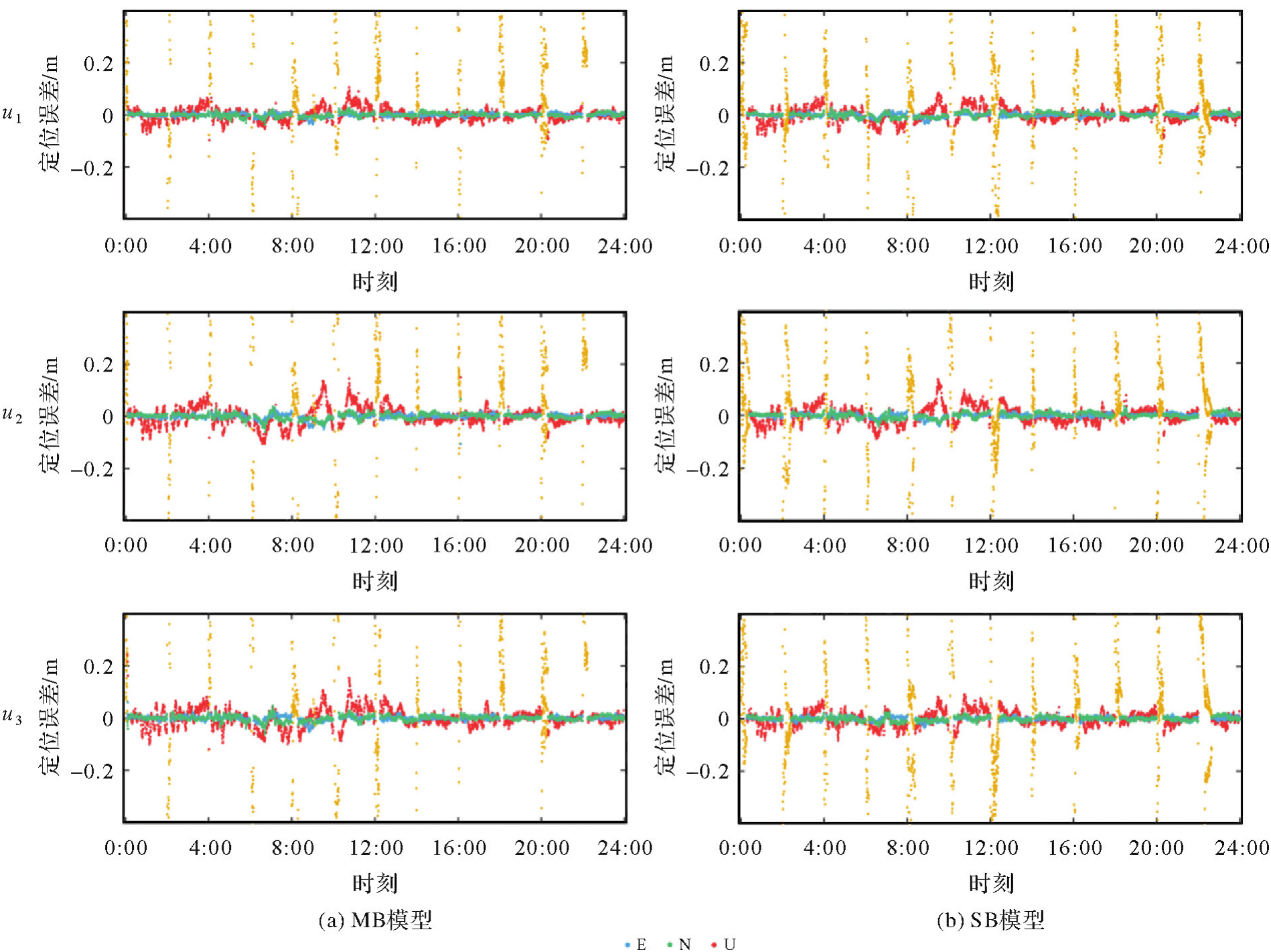
图15
重收敛时间频率统计"

| [1] | HAN Junqiang, HUANG Guanwen, ZHANG Qin, et al. A new azimuth-dependent elevation weight (ADEW) model for real-time deformation monitoring in complex environment by multi-GNSS[J]. Sensors, 2018, 18(8): 2473-2488. |
| [2] | JIANG Weiping, CHEN Yan, CHEN Qusen, et al. High precision deformation monitoring with integrated GNSS and ground range observations in harsh environment[J]. Measurement, 2022, 204: 112179-112188. |
| [3] | GAO Rui, LIU Zhizhao, ODOLINSKI R, et al. Hong Kong-Zhuhai-Macao bridge deformation monitoring using PPP-RTK with multipath correction method[J]. GPS Solutions, 2023, 27(4): 195-209. |
| [4] | WANG Duo, HUANG Guanwen, DU Yuan, et al. Stability analysis of reference station and compensation for monitoring stations in GNSS landslide monitoring[J]. Satellite Navigation, 2023, 4(1): 29-43. |
| [5] |
黄观文, 陈孜, 徐永福. 膨胀土边坡GNSS实时监测技术[J]. 测绘学报, 2023, 52(11): 1873-1882. DOI: .
doi: 10.11947/j.AGCS.2023.20220562 |
|
HUANG Guanwen, CHEN Zi, XU Yongfu. GNSS real-time monitoring technology of expansive soil slope[J]. Acta Geodaetica et Cartographica Sinica, 2023, 52(11): 1873-1882. DOI: .
doi: 10.11947/j.AGCS.2023.20220562 |
|
| [6] |
白正伟, 张勤, 黄观文, 等. “轻终端+行业云”的实时北斗滑坡监测技术[J]. 测绘学报, 2019, 48(11): 1424-1429. DOI: .
doi: 10.11947/j.AGCS.2019.20190167 |
|
BAI Zhengwei, ZHANG Qin, HUANG Guanwen, et al. Real-time BeiDou landslide monitoring technology of “light terminal plus industry cloud”[J]. Acta Geodaetica et Cartographica Sinica, 2019, 48(11): 1424-1429. DOI: .
doi: 10.11947/j.AGCS.2019.20190167 |
|
| [7] | SHI Junbo, HUANG Yongshuai, OUYANG Chenhao. A GPS relative positioning quality control algorithm considering both code and phase observation errors[J]. Journal of Geodesy, 2019, 93(9): 1419-1433. |
| [8] | 李海洋. 复杂环境下BDS/GNSS桥梁变形监测算法的研究与应用分析[D]. 武汉: 武汉大学, 2022. |
| LI Haiyang. Research and application analysis of BDS/GNSS bridge deformation monitoring algorithm in complex environment[D]. Wuhan: Wuhan University, 2022. | |
| [9] | XUE Chenyu, PSIMOULIS P A, MENG Xiaolin. Feasibility analysis of the performance of low-cost GNSS receivers in monitoring dynamic motion[J]. Measurement, 2022, 202: 111819-111834. |
| [10] | 栗广才. 大众智能手机GNSS模糊度固定理论与方法[D]. 武汉: 武汉大学, 2021. |
| LI Guangcai. Theory and method of GNSS ambiguity resolution for smartphones[D]. Wuhan: Wuhan University, 2021. | |
| [11] | LI Haiyang, NIE Guigen, CHEN Dezhong, et al. Constrained MLAMBDA method for multi-GNSS structural health monitoring[J]. Sensors, 2019, 19(20): 4462-4472. |
| [12] | 戴吾蛟. GPS精密动态变形监测的数据处理理论与方法研究[D]. 长沙: 中南大学, 2007. |
| DAI Wujiao. A study of data processing for precise dynamic deformation monitoring using GPS[D]. Changsha: Central South University, 2007. | |
| [13] | HOU Cheng, SHI Junbo, OUYANG Chenhao, et al. A dual-base station constraint method to improve deformation monitoring precision consistency in strip regions[J]. Satellite Navigation, 2024, 5(1): 26-40. |
| [14] | JING Ce, HUANG Guanwen, ZHANG Qin, et al. GNSS/accelerometer adaptive coupled landslide deformation monitoring technology[J]. Remote Sensing, 2022, 14(15): 3537-3557. |
| [15] | SUN Ao, ZHANG Qiuzhao, YU Zhangjun, et al. A novel slow-growing gross error detection method for GNSS/accelerometer integrated deformation monitoring based on state domain consistency theory[J]. Remote Sensing, 2022, 14(19): 4758-4775. |
| [16] | JIANG Chen, ZHANG Shubi, CAO Yizhi, et al. A robust fault detection algorithm for the GNSS/INS integrated navigation systems[J]. Journal of Geodesy and Geoinformation Science, 2020, 3(1): 12-24. |
| [17] | HUANG Guanwen, DU Shi, WANG Duo. GNSS techniques for real-time monitoring of landslides: a review[J]. Satellite Navigation, 2023, 4(1): 5-14. |
| [18] | BIAN Hefang, ZHANG Shubi, ZHANG Qiuzhao, et al. Monitoring large-area mining subsidence by GNSS based on IGS stations[J]. Transactions of Nonferrous Metals Society of China, 2014, 24(2): 514-519. |
| [19] | WANG Haonan, DAI Wujiao, YU Wenkun. BDS/GPS multi-baseline relative positioning for deformation monitoring[J]. Remote Sensing, 2022, 14(16): 3884-3898. |
| [20] | LU L, LIU W, ZHANG X. An effective QR-based reduction algorithm for the fast estimation of GNSS high-dimensional ambiguity resolution[J]. Survey Review, 2018, 50(358): 57-68. |
| [21] | LI Bofeng, SHEN Yunzhong, FENG Yanming, et al. GNSS ambiguity resolution with controllable failure rate for long baseline network RTK[J]. Journal of Geodesy, 2014, 88(2): 99-112. |
| [22] | LI Bofeng, QIN Yanan, LIU Tianxia. Geometry-based cycle slip and data gap repair for multi-GNSS and multi-frequency observations[J]. Journal of Geodesy, 2019, 93(3): 399-417. |
| [23] |
崔阳, 吕志平, 李林阳, 等. GNSS大网双差模型并行快速解算方法[J]. 测绘学报, 2017, 46(7): 848-856. DOI: .
doi: 10.11947/j.AGCS.2017.20160585 |
|
CUI Yang, LÜ Zhiping, LI Linyang, et al. A fast parallel processing strategy of double difference model for GNSS huge networks[J]. Acta Geodaetica et Cartographica Sinica, 2017, 46(7): 848-856. DOI: .
doi: 10.11947/j.AGCS.2017.20160585 |
|
| [24] | TEUNISSEN P J G. A canonical theory for short GPS baselines. Part I: the baseline precision[J]. Journal of Geodesy, 1997, 71(6): 320-336. |
| [25] | VERHAGEN S, LI Bofeng, TEUNISSEN P J G. Ps-LAMBDA: ambiguity success rate evaluation software for interferometric applications[J]. Computers & Geosciences, 2013, 54: 361-376. |
| [26] | TEUNISSEN P J G. Success probability of integer GPS ambiguity rounding and bootstrapping[J]. Journal of Geodesy, 1998, 72(10): 606-612. |
| [27] | 姜卫平, 刘鸿飞, 刘万科, 等. 西龙池上水库GPS变形监测系统研究及实现[J]. 武汉大学学报(信息科学版), 2012, 37(8): 949-952, 1009. |
| JIANG Weiping, LIU Hongfei, LIU Wanke, et al. CORS development for xilongchi dam deformation monitoring[J]. Geomatics and Information Science of Wuhan University, 2012, 37(8): 949-952, 1009. | |
| [28] | LI Bofeng, TEUNISSEN P J G. GNSS antenna array-aided CORS ambiguity resolution[J]. Journal of Geodesy, 2014, 88(4): 363-376. |
| [29] | TEUNISSEN P J G, MONTENBRUCK O. Springer handbook of global navigation satellite systems[M]. Berlin: Springer, 2017. |
| [30] | WANG Xinpeng, ZHAO Qingzhi, XI Ruijie, et al. Review of bridge structural health monitoring based on GNSS: from displacement monitoring to dynamic characteristic identification[J]. IEEE Access, 2021, 9: 80043-80065. |
| [31] | XI Ruijie, JIANG Weiping, XUAN Wei, et al. Performance assessment of structural monitoring of a dedicated high-speed railway bridge using a moving-base RTK-GNSS method[J]. Remote Sensing, 2023, 15(12): 3132-3149. |
| [1] | 布金伟, 刘淑慧, 徐顺双, 向彤粟, 汪秋兰, 籍超颖, 左小清. 星载GNSS-R全球海浪波周期估计的经验模型构建[J]. 测绘学报, 2026, 55(4): 684-697. |
| [2] | 吴汤婷, 罗馨语, 卢立果, 刘站科, 超能芳. 基于GNSS和GRACE/GRACE-FO的陕甘宁地区水资源与水文干旱特征时空变化评价[J]. 测绘学报, 2026, 55(3): 439-450. |
| [3] | 马中民, 张双成, 周昕, 刘奇, 刘宁, 王恒利. 顾及地表反射率不确定性的风云三号GNSS-R洪涝监测方法:以8·2广东极端暴雨灾害为例[J]. 测绘学报, 2026, 55(3): 451-464. |
| [4] | 严清赟, 郭紫璇, 潘元进, 贾燕, 金双根. GNSS-R陆表反射率空间分异驱动因子定量分析与分区模式[J]. 测绘学报, 2026, 55(2): 315-327. |
| [5] | 赵庆志, 蒋朵朵, 姚宜斌, 马智, 马永杰, 李浩杰, 薛瑞瑞. 一种GNSS卫星信号自适应优选的水汽层析方法[J]. 测绘学报, 2026, 55(1): 25-35. |
| [6] | 余德荧, 李厚朴, 刘一, 武曙光, 李得宴, 李明超, 李文魁, 边少锋. 基于DBSCAN的多粗差识别RAIM算法[J]. 测绘学报, 2026, 55(1): 59-72. |
| [7] | 程栋梁, 陈灵秋, 黄志勇, 乔书波, 王丹丹, 闫亚明. 基于COATS的多模多频iGNSS-R测高性能评估[J]. 测绘学报, 2026, 55(1): 73-89. |
| [8] | 刘忠贺, 李宗春, 何华, 郭迎钢, 赵文斌. 联合稳健S变换与K均值聚类的高崩溃污染率拟稳点选取策略[J]. 测绘学报, 2025, 54(9): 1608-1619. |
| [9] | 罗亚荣, 卢文韬, 郭迟, 刘经南. GNSS/INS组合导航左手对称性等变滤波模型及算法[J]. 测绘学报, 2025, 54(8): 1389-1403. |
| [10] | 陈洋溢, 郑凯, 张小红, 吴明魁, 王鹏旭, 付文举, 刘克中. GPS/Galileo/BDS重叠频率多路径误差分析及建模[J]. 测绘学报, 2025, 54(8): 1427-1438. |
| [11] | 李建章, 闫浩文, 杨维芳, 苏小宁. GNSS伪三角高程测量方法[J]. 测绘学报, 2025, 54(7): 1170-1177. |
| [12] | 王潜心, 胡超, 程彤. 基于GNSS钟差参数先验信息的超快速轨道钟差估计方法[J]. 测绘学报, 2025, 54(6): 982-994. |
| [13] | 沈洋, 李广云, 陈明剑, 李林阳, 施星宇, 蔡巍, 郝卫峰. 基于风云三号TEC的极区GNSS电离层模型精度评估[J]. 测绘学报, 2025, 54(6): 995-1008. |
| [14] | 胡顺强, 陈克杰, 贺小星, 朱海, 王坦. 环境负载对川滇地区GNSS观测站三维坐标时间序列非线性变化的影响[J]. 测绘学报, 2025, 54(5): 805-818. |
| [15] | 杨文涛, 郭斐, 张小红, 张治宇, 朱逸凡, 李政, 吴子恒. 利用GNSS反射计和SMAP辐射计反演青藏高原土壤湿度和冻融状态[J]. 测绘学报, 2025, 54(4): 725-735. |
| 阅读次数 | ||||||
|
全文 |
|
|||||
|
摘要 |
|
|||||