

Acta Geodaetica et Cartographica Sinica ›› 2025, Vol. 54 ›› Issue (3): 536-551.doi: 10.11947/j.AGCS.2025.20240279
• Cartography and Geoinformation • Previous Articles Next Articles
Bingrong CHEN1( ), Kaiqi CHEN1, Min DENG1(), Cheng HUANG2,3, Qinghao LIU1
Received:2024-07-08
Online:2025-04-11
Published:2025-04-11
Contact:
Min DENG
E-mail:brchen@csu.edu.cn;dengmin@csu.edu.cn
About author:CHEN Bingrong (1997—), female, PhD candidate, majors in spatio-temporal big data mining and spatial causality mining. E-mail: brchen@csu.edu.cn
Supported by:CLC Number:
Bingrong CHEN, Kaiqi CHEN, Min DENG, Cheng HUANG, Qinghao LIU. Method for discovering spatial causality in geological hazards guided by spatial association patterns[J]. Acta Geodaetica et Cartographica Sinica, 2025, 54(3): 536-551.

Fig. 1
Flowchart of spatial causality discovery method guided by spatial association patterns"
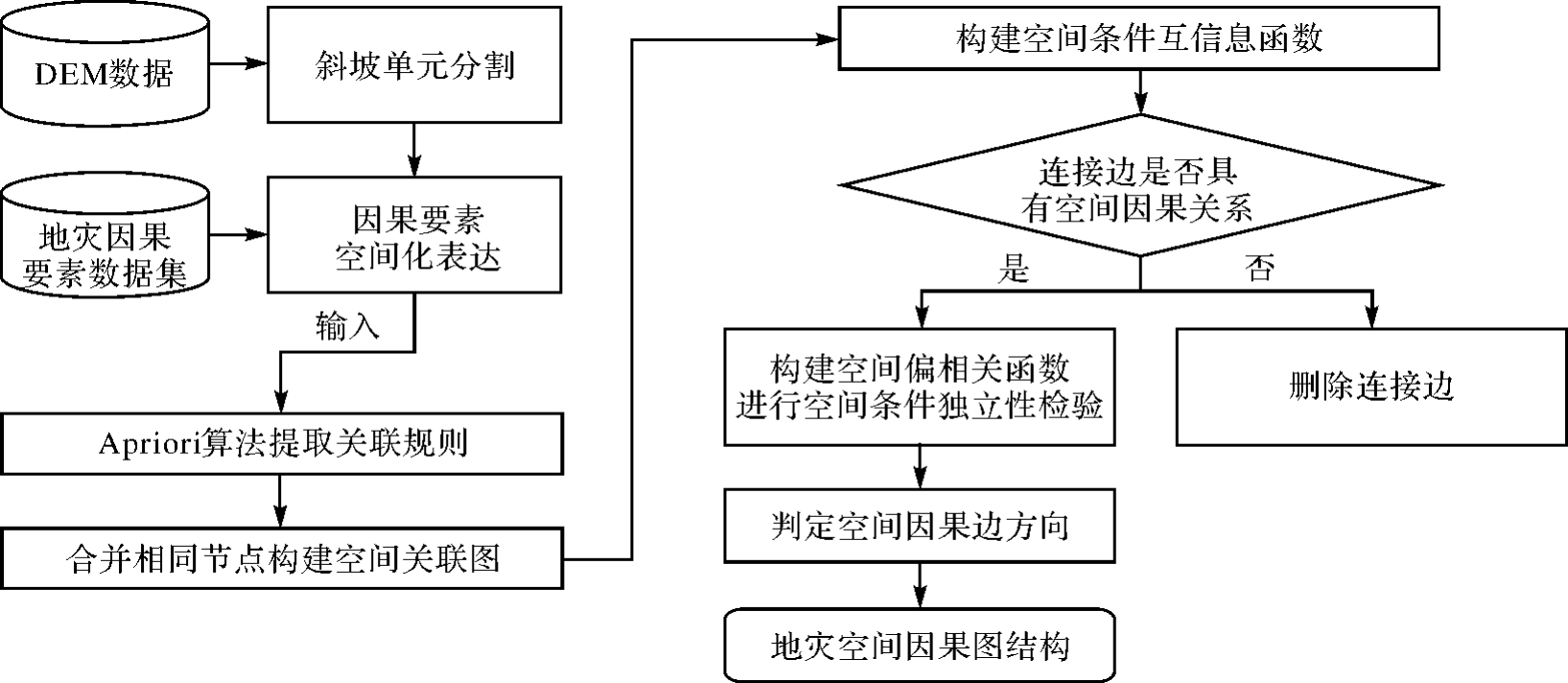
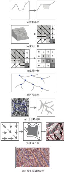
Fig. 2
Flowchart of slope unit division"

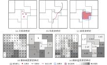
Fig. 3
Spatial expression rules for geological disaster elements of different data types"

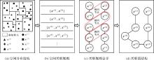
Fig. 4
Association diagram based on spatial association rules"

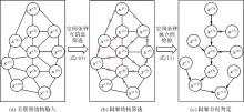
Fig. 5
Flowchart of the Spatial-PC algorithm"
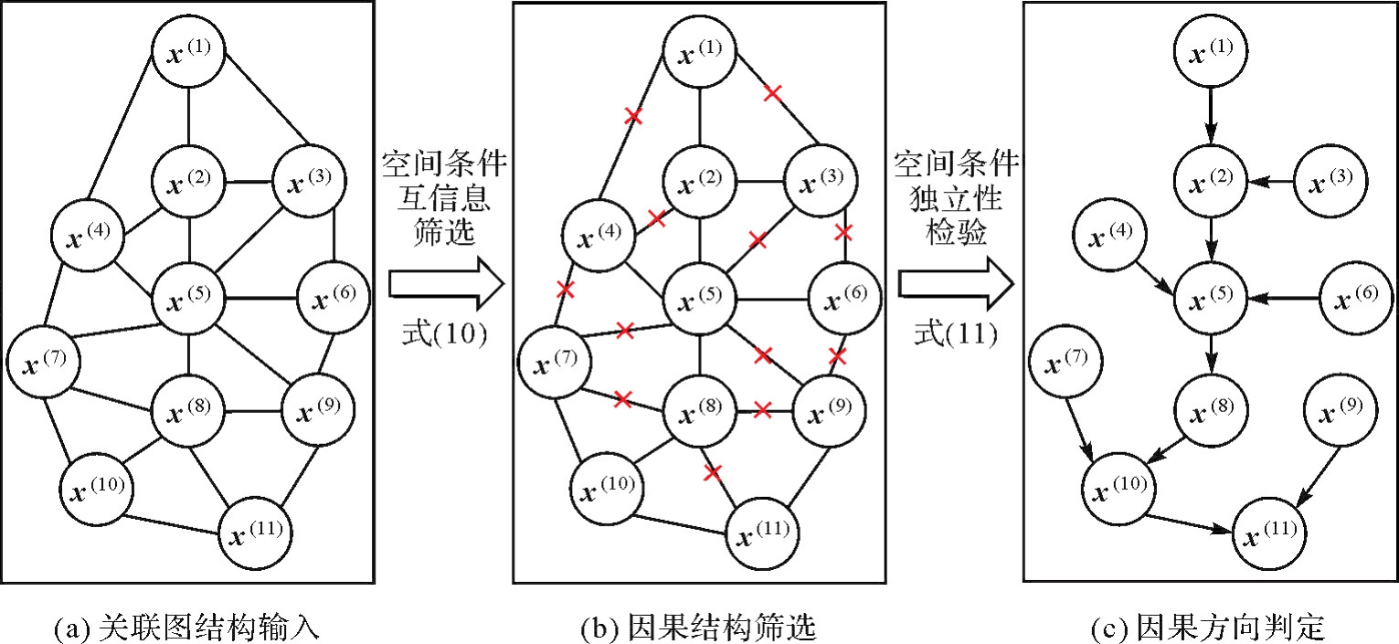
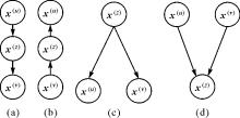
Fig. 6
Four causal structures of three elements"

Fig. 7
Spatio-temporal distribution of major geological disaster events in Yunnan province from 2019 to 2023"

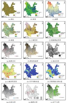
Fig. 8
Spatial distribution of causal elements of geological disasters"

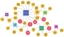
Fig. 9
Spatial causal graph structure of geological disasters in Yunnan province"

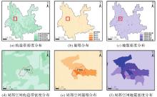
Fig. 10
Spatial visualization of causal elements in the spatial causal relationship “high tectonic belt density → high earthquake density → collapse”"
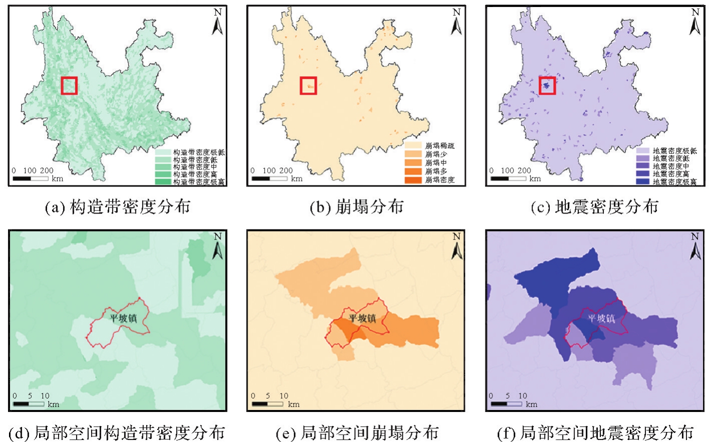
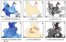
Fig. 11
Spatial visualization of causal elements in the spatial causal relationship “high monthly cumulative rainfall → collapse ← large carbonate rock area”"

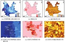
Fig. 12
Spatial visualization of causal elements in the spatial causal relationship “high monthly cumulative rainfall → landslide ← high Slope”"

Tab. 1
Comparative analysis of spatial causal chains, non-spatial causal chains, and spatial association patterns"
| 因素组合 | 空间因果关系 | 非空间因果关系 | 空间关联关系因素 |
|---|---|---|---|
| 二元 | 月累积最大降雨量大→滑坡 | 月累积最大降雨量大→滑坡 | 月累积最大降雨量大、滑坡 |
| 地震密度高→崩塌 | 崩塌→地震密度高 | 坡度大、滑坡 | |
| 松散土体面积大→地面塌陷 | 松散土体面积大→地面塌陷 | 形变速率高、地面塌陷 | |
| 坡度大→滑坡 | 滑坡→地震密度高 | 峡谷区面积大、泥石流 | |
| 峡谷区面积大→泥石流 | 地震密度高→构造带密度高 | 构造带密度大、崩塌 | |
| 三元 | 构造带密度高→地震密度高→崩塌 | 构造带密度大→地震密度高→滑坡 | 地震密度大、滑坡、坡度大 |
| 月累积最大降雨量大→滑坡←坡度大 | 地震密度高→裸地面积大→崩塌 | 月累积最大降雨量大、泥石流、坡度大 | |
| 月累积最大降雨量大→崩塌←碳酸盐岩面积大 | 地震→月累积最大降雨量大→滑坡 | 地震密度大、地裂缝、裸地面积大 | |
| 水系密度高→崩塌←软硬岩互层面积大 | 坡度大→月累积最大降雨量大→滑坡 | 月累积最大降雨量大、坡度大、滑坡 | |
| 月累积最大降雨量大→泥石流←红壤面积大 | 月累积最大降雨量大→小丘陵面积大→泥石流 | 月累积最大降雨量大、地震密度高、滑坡 |
Tab. 2
Mention rate of geological survey reports"
| 空间因果关系 | 提及率/(%) | 调查报告来源 |
|---|---|---|
| 坡度大→滑坡←月累积最大降雨量大 | 79.6 | 云南省禄劝县地质灾害详细调查报告(2020)[ |
| 坡度较大→泥石流←月平均降雨量极大 | 78.3 | 云南省禄劝县地质灾害详细调查报告(2007)[ |
| 构造带密度高→地震密度高→崩塌 | 75.2 | 云南省玉龙纳西族自治县地质灾害详细调查报告(2017)[ |
| 月平均最大降雨量大→滑坡 | 72.8 | 云南省河口瑶族自治县地质灾害详细调查报告(2008)[ |
| 地震→崩塌 | 71.4 | 云南省红河县地质灾害详细调查报告(2009)[ |
| 峡谷区面积大→泥石流 | 68.4 | 哀牢山地区元江县地质灾害详细调查报告(2010)[ |
| 坡度大→滑坡 | 65.7 | 云南省金平县地质灾害详细调查报告(2009)[ |
| 月累积最大降雨量大→崩塌←碳酸盐岩面积大 | 59.4 | 云南省宣威市地质灾害详细调查报告(2015)[ |
| 水系密度高→崩塌←软硬岩互层面积大 | 50.6 | 云南哀牢山地区地质灾害详细调查报告(2011)[ |
Tab. 3
Comparison of prediction accuracy"
| 方法 | TOP-2要素组合 | TOP-3要素组合 | TOP-4要素组合 |
|---|---|---|---|
| 支持向量机 | 54.6 | 57.2 | 78.1 |
| 地理探测器 | 46.2 | 54.4 | 65.2 |
| 地理加权回归 | 51.5 | 49.3 | 72.7 |
| 本文方法 | 56.7 | 62.5 | 81.6 |
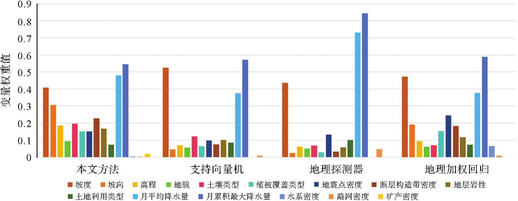
Tab. A1
The comparison of SCMI values in proposed method with contribution rates in other three methods"
| 要素 | 本文方法 | 支持向量机 | 地理探测器 | 地理加权回归 |
|---|---|---|---|---|
| 月累积最大降水量 | 0.547 | 0.572 | 0.843 | 0.589 |
| 月平均降水量 | 0.481 | 0.376 | 0.731 | 0.379 |
| 坡度 | 0.410 | 0.526 | 0.436 | 0.473 |
| 坡向 | 0.308 | 0.047 | 0.0259 | 0.192 |
| 土壤类型 | 0.196 | 0.122 | 0.070 | 0.072 |
| 高程 | 0.187 | 0.071 | 0.061 | 0.095 |
| 植被覆盖类型 | 0.153 | 0.064 | 0.027 8 | 0.144 |
| 断层构造带密度 | 0.228 | 0.076 | 0.033 9 | 0.183 |
| 地层岩性 | 0.167 | 0.102 | 0.058 | 0.117 |
| 地震点密度 | 0.152 | 0.098 | 0.132 | 0.247 |
| 地貌 | 0.094 | 0.056 2 | 0.052 | 0.062 |
| 土地利用类型 | 0.074 | 0.086 4 | 0.103 | 0.074 |
| 矿产密度 | 0.019 4 | 0.000 42 | 0.002 4 | 0.000 61 |
| 水系密度 | 0.005 7 | 0.000 8 | 0.002 8 | 0.064 |
| 路网密度 | 0.003 6 | 0.010 4 | 0.048 | 0.009 5 |

Fig. A1
Comparison of the trend distribution of variable contribution rates of different models"
| [1] | PEARL J. Causality[M]. Cambridge: Cambridge University Press, 2009. |
| [2] | GAO Bingbo, WANG Jinfeng, STEIN A, et al. Causal inference in spatial statistics[J]. Spatial Statistics, 2022, 50: 100621. |
| [3] | AKBARI K, WINTER S, TOMKO M. Spatial causality: a systematic review on spatial causal inference[J]. Geographical Analysis, 2023, 55(1): 56-89. |
| [4] | 傅伯杰. 地理学:从知识、科学到决策[J]. 地理学报, 2017, 72(11): 1923-1932. |
| FU Bojie. Geography: from knowledge, science to decision making support[J]. Acta Geographica Sinica, 2017, 72(11): 1923-1932. | |
| [5] | CHEN Kaiqi, LIU Enbo, DENG Min, et al. DKNN: deep Kriging neural network for interpretable geospatial interpolation[J]. International Journal of Geographical Information Science, 2024, 38(8): 1486-1530. |
| [6] | 程昌秀, 裴韬, 刘瑜, 等. 新时代自然灾害态势感知的实践与方法探索[J]. 地理学报, 2023, 78(3): 548-557. |
| CHENG Changxiu, PEI Tao, LIU Yu, et al. The practice and method of natural disasters situational awareness in the new era[J]. Acta Geographica Sinica, 2023, 78(3): 548-557. | |
| [7] | PEARL J, MACKENZIE D. The book of why: the new science of cause and effect[M]. New York: Basic books, 2018. |
| [8] | 闫坤如, 李宏. 大数据时代的“统计陷阱”及其规避探析[J]. 学术研究, 2020(5): 23-28. |
| YAN Kunru, LI Hong. The “statistical trap” in the big data era and its avoidance[J]. Academic Research, 2020(5): 23-28. | |
| [9] | REICH B J, YANG Shu, GUAN Yawen, et al. A review of spatial causal inference methods for environmental and epidemiological applications[J]. International Statistical Review, 2021, 89(3): 605-634. |
| [10] | WANG Zhensheng, YUE Yang, HE Biao, et al. A Bayesian spatio-temporal model to analyzing the stability of patterns of population distribution in an urban space using mobile phone data[J]. International Journal of Geographical Information Science, 2021, 35(1): 116-134. |
| [11] | JARNER M F, DIGGLE P, CHETWYND A G. Estimation of spatial variation in risk using matched case-control data[J]. Biometrical Journal, 2002, 44(8): 936-945. |
| [12] | GIFFIN A, REICH B J, YANG S, et al. Generalized propensity score approach to causal inference with spatial interference[J]. Biometrics, 2023, 79(3): 2220-2231. |
| [13] | BARDAKA E, DELGADO M S, FLORAX R J G M. A spatial multiple treatment/multiple outcome difference-in-differences model with an application to urban rail infrastructure and gentrification[J]. Transportation Research Part A: Policy and Practice, 2019, 121: 325-345. |
| [14] | DAS M, GHOSH S K, GUPTA P, et al. FORWARD: a model for forecasting reservoir water dynamics using spatial Bayesian network (SpaBN)[J]. IEEE Transactions on Knowledge and Data Engineering, 2017, 29(4): 842-855. |
| [15] | 杨俊, 李雪铭, 张云, 等. 基于因果网络模型的城市生态安全空间分异:以大连市为例[J]. 生态学报, 2008, 28(6): 2774-2783. |
| YANG Jun, LI Xueming, ZHANG Yun, et al. Assessment on urban ecological security spatial differences based on causal network: a case of Dalian city[J]. Acta Ecologica Sinica, 2008, 28(6): 2774-2783. | |
| [16] | NOWACK P, RUNGE J, EYRING V, et al. Causal networks for climate model evaluation and constrained projections[J]. Nature Communications, 2020, 11(1): 1415. |
| [17] | GAO Bingbo, YANG Jianyu, CHEN Ziyue, et al. Causal inference from cross-sectional earth system data with geographical convergent cross mapping[J]. Nature Communications, 2023, 14(1): 5875. |
| [18] |
邓敏, 谌恺祺, 石岩, 等. 多尺度空间同位模式挖掘的点过程分解方法[J]. 测绘学报, 2022, 51(2): 258-268. DOI:.
doi: 10.11947/j.AGCS.2022.20200548 |
|
DENG Min, CHEN Kaiqi, SHI Yan, et al. Point process decomposition method for multi-scale spatial co-location pattern mining[J]. Acta Geodaetica et Cartographica Sinica, 2022, 51(2): 258-268. DOI:.
doi: 10.11947/j.AGCS.2022.20200548 |
|
| [19] | 刘恩博, 谌恺祺, 石岩, 等. 数据不确定性下的犯罪事件热点探测方法[J/OL]. 武汉大学学报(信息科学版),2023, 1-14[2024-07-05]. https://doi.org/10.13203/j.whugis20220100. |
|
LIU Enbo, CHEN Kaiqi, SHI Yan, et al. A hot spot detection method of criminal events under data uncertainty[J/OL]. Geomatics and Information Science of Wuhan University. 1-14[2024-07-05]. DOI:.
doi: 10.13203/j.whugis20220100 |
|
| [20] | 贺炜, 潘泉, 陈玉春, 等. 关联规则挖掘与因果关系发现的比较研究[J]. 模式识别与人工智能, 2005, 18(3): 328-333. |
| HE Wei, PAN Quan, CHEN Yuchun, et al. A comparison between association rule data mining and causal discovery[J]. Pattern Recognition and Artificial Intelligence, 2005, 18(3): 328-333. | |
| [21] | 铁永波, 张宪政, 龚凌枫, 等. 西南山区典型地质灾害链成灾模式研究[J]. 地质力学学报, 2022, 28(6): 1071-1080. |
| TIE Yongbo, ZHANG Xianzheng, GONG Lingfeng, et al. Research on the pattern of typical geohazard chains in the southwest mountainous region, China[J]. Journal of Geomechanics, 2022, 28(6): 1071-1080. | |
| [22] |
朱庆, 曾浩炜, 丁雨淋, 等. 重大滑坡隐患分析方法综述[J]. 测绘学报, 2019, 48(12): 1551-1561. DOI:.
doi: 10.11947/j.AGCS.2019.20190452 |
|
ZHU Qing, ZENG Haowei, DING Yulin, et al. A review of major potential landslide hazards analysis[J]. Acta Geodaetica et Cartographica Sinica, 2019, 48(12): 1551-1561. DOI:.
doi: 10.11947/j.AGCS.2019.20190452 |
|
| [23] | 杜云艳, 易嘉伟, 薛存金, 等. 多源地理大数据支撑下的地理事件建模与分析[J]. 地理学报, 2021, 76(11): 2853-2866. |
| DU Yunyan, YI Jiawei, XUE Cunjin, et al. Modeling and analysis of geographic events supported by multi-source geographic big data[J]. Acta Geographica Sinica, 2021, 76(11): 2853-2866. | |
| [24] | 刘越凡, 付萧, 朱庆, 等. 顾及地貌形态特征的精细斜坡单元高效分区划分[J]. 测绘科学, 2023, 48(4): 211-220. |
| LIU Yuefan, FU Xiao, ZHU Qing, et al. An efficient and fine slope units division method with consideration of the regional geomorphological characteristics[J]. Science of Surveying and Mapping, 2023, 48(4): 211-220. | |
| [25] | 胡凯衡, 魏丽, 刘双, 等. 横断山区泥石流空间格局和激发雨量分异性研究[J]. 地理学报, 2019, 74(11): 2303-2313. |
| HU Kaiheng, WEI Li, LIU Shuang, et al. Spatial pattern of debris-flow catchments and the rainfall amount of triggering debris flows in the Hengduan Mountains region[J]. Acta Geographica Sinica, 2019, 74(11): 2303-2313. | |
| [26] | LI Weilian, ZHU Jun, FU Lin, et al. An augmented representation method of debris flow scenes to improve public perception[J]. International Journal of Geographical Information Science, 2021, 35(8): 1521-1544. |
| [27] | 杨迎冬, 晏祥省, 王宇, 等. 云南省地质灾害特征及形成规律研究[J]. 灾害学, 2021, 36(3): 131-139. |
| YANG Yingdong, YAN Xiangsheng, WANG Yu, et al. The characteristics and formation of geological hazards in Yunnan province[J]. Journal of Catastrophology, 2021, 36(3): 131-139. | |
| [28] |
刘纪平, 梁恩婕, 徐胜华, 等. 顾及样本优化选择的多核支持向量机滑坡灾害易发性分析评价[J]. 测绘学报, 2022, 51(10): 2034-2045. DOI:.
doi: 10.11947/j.AGCS.2022.20220326 |
|
LIU Jiping, LIANG Enjie, XU Shenghua, et al. Multi-kernel support vector machine considering sample optimization selection for analysis and evaluation of landslide disaster susceptibility[J]. Acta Geodaetica et Cartographica Sinica, 2022, 51(10): 2034-2045. DOI:.
doi: 10.11947/j.AGCS.2022.20220326 |
|
| [29] |
蔡建南, 刘启亮, 徐枫, 等. 多层次空间同位模式自适应挖掘方法[J]. 测绘学报, 2016, 45(4): 475-485. DOI:.
doi: 10.11947/j.AGCS.2016.20150337 |
|
CAI Jiannan, LIU Qiliang, XU Feng, et al. An adaptive method for mining hierarchical spatial co-location patterns[J]. Acta Geodaetica et Cartographica Sinica, 2016, 45(4): 475-485. DOI:.
doi: 10.11947/j.AGCS.2016.20150337 |
|
| [30] | KALISCH M, BÜHLMANN P. Estimating high-dimensional directed acyclic graphs with the PC-algorithm[J]. Journal of Machine Learning Research, 2007, 8: 613-636. |
| [31] | GAO Bingbo, LI Manchun, WANG Jinfeng, et al. Temporally or spatially? causation inference in earth system sciences[J]. Science Bulletin, 2022, 67(3): 232-235. |
| [32] | 苏建宾, 陈都鑫, 郑东海, 等. 追索为什么?地球系统科学中的因果推理[J]. 中国科学:地球科学, 2023, 53(10): 2199-2216. |
| SU Jianbin, CHEN Duxin, ZHENG Donghai, et al. The insight of why: causal inference in Earth system science[J]. Science China Earth Sciences, 2023, 53(10): 2199-2216. | |
| [33] | 李海峰, 罗琴瑶, 贺丝露, 等. 地理空间因果原则及地理空间效应的因果发现[J]. 武汉大学学报(信息科学版), 2023, 48(11): 1800-1812. |
| LI Haifeng, LUO Qinyao, HE Silu, et al. Geospatial causal principle and causal discovery for geospatial effects[J]. Geomatics and Information Science of Wuhan University, 2023, 48(11): 1800-1812. | |
| [34] | ZHOU Xinzhi, WEN Haijia, ZHANG Yalan, et al. Landslide susceptibility mapping using hybrid random forest with GeoDetector and RFE for factor optimization[J]. Geoscience Frontiers, 2021, 12(5): 101211. |
| [35] | CHEN Ziyue, CAI Jun, GAO Bingbo, et al. Detecting the causality influence of individual meteorological factors on local PM2.5 concentration in the Jing-Jin-Ji region[J]. Scientific Reports, 2017, 7: 40735. |
| [36] | CELIK T. Spatial mutual information and PageRank-based contrast enhancement and quality-aware relative contrast measure[J]. IEEE Transactions on Image Processing, 2016, 25(10): 4719-4728. |
| [37] | 杨竹云, 许彦艳, 李华宏, 等. 云南省地质灾害气象风险预警技术改进及应用检验[J]. 灾害学, 2024, 39(2): 85-91. |
| YANG Zhuyun, XU Yanyan, LI Huahong, et al. Improvement and application verification of meteorological risk early warning technology for geological disasters in Yunnan province[J]. Journal of Catastrophology, 2024, 39(2): 85-91. | |
| [38] | 宋源昆, 李攀, 李雪松, 等. 云南省禄劝县地质灾害详细调查报告[EB/OL]. [2024-10-16]. https://www.ngac.cn/dzzlfw_sjgl/d2d/dse/category/detail.do?method=cdetail&_id=225_14053&tableCode=ty_qgg_edmk_t_ajxx&categoryCode=dzzlk#. |
| SONG Yuankun, LI Pan, LI Xuesong, et al. Detailed investigation report on geologic hazards in Luquan county, Yunnan province[EB/OL]. [2024-10-16]. https://www.ngac.cn/dzzlfw_sjgl/d2d/dse/category/detail.do?method=cdetail&_id=225_14053&tableCode=ty_qgg_edmk_t_ajxx&categoryCode=dzzlk#. | |
| [39] | 祝传兵, 李煌新, 任世川, 等. 云南省禄劝县地质灾害详细调查报告[EB/OL]. [2024-10-16]. https://www.ngac.cn/dzzlfw_sjgl/d2d/dse/category/detail.do?method=cdetail&_id=102_129565&tableCode=ty_qgg_edmk_t_ajxx&categoryCode=dzzlk. |
| ZHU Chuanbing, LI Huangxin, REN Shichuan, et al. Detailed investigation report on geologic hazards in Luquan county, Yunnan province[EB/OL]. [2024-10-16]. https://www.ngac.cn/dzzlfw_sjgl/d2d/dse/category/detail.do?method=cdetail&_id=102_129565&tableCode=ty_qgg_edmk_t_ajxx&categoryCode=dzzlk. | |
| [40] | 任世川, 孙有国, 和怀中, 等. 云南省玉龙纳西族自治县地质灾害详细调查报告[EB/OL]. [2024-10-16]. https://www.ngac.cn/dzzlfw_sjgl/d2d/dse/category/detail.do?method=cdetail&_id=225_13089&tableCode=ty_qgg_edmk_t_ajxx&categoryCode=dzzlk. |
| REN Shichuan, SUN Youguo, HE Huaizhong, et al. Detailed investigation report on geologic hazards in Yulong Naxi autonomous county, Yunnan province[EB/OL]. [2024-10-16]. https://www.ngac.cn/dzzlfw_sjgl/d2d/dse/category/detail.do?method=cdetail&_id=225_13089&tableCode=ty_qgg_edmk_t_ajxx&categoryCode=dzzlk. | |
| [41] | 陈亮, 韩冰, 胡斌, 等. 云南省河口瑶族自治县地质灾害详细调查报告[EB/OL]. [2024-10-16]. https://www.ngac.cn/dzzlfw_sjgl/d2d/dse/category/detail.do?method=cdetail&_id=102_113998&tableCode=ty_qgg_edmk_t_ajxx&categoryCode=dzzlk. |
| CHEN Liang, HAN Bing, HU Bin, et al. Detailed investigation report on geological hazards in Hekou Yao autonomous county, Yunnan province[EB/OL]. [2024-10-16]. https://www.ngac.cn/dzzlfw_sjgl/d2d/dse/category/detail.do?method=cdetail&_id=102_113998&tableCode=ty_qgg_edmk_t_ajxx&categoryCode=dzzlk. | |
| [42] | 王研, 张能, 曾愿, 等. 云南省红河县地质灾害详细调查报告[EB/OL]. [2024-10-16]. https://www.ngac.cn/dzzlfw_sjgl/d2d/dse/category/detail.do?method=cdetail&_id=102_117548&tableCode=ty_qgg_edmk_t_ajxx&categoryCode=dzzlk. |
| WANG Yan, ZHANG Neng, ZENG Yuan, et al. Detailed investigation report on geological hazards in Honghe county, Yunnan province.[EB/OL]. [2024-10-16]. https://www.ngac.cn/dzzlfw_sjgl/d2d/dse/category/detail.do?method=cdetail&_id=102_117548&tableCode=ty_qgg_edmk_t_ajxx&categoryCode=dzzlk. | |
| [43] | 张杰, 张汝祥, 曹瑾, 等. 哀牢山地区元江县地质灾害详细调查报告[EB/OL]. [2024-10-16]. https://www.ngac.cn/dzzlfw_sjgl/d2d/dse/category/detail.do?method=cdetail&_id=102_129557&tableCode=ty_qgg_edmk_t_ajxx&categoryCode=dzzlk. |
| ZHANG Jie, ZHANG Ruxiang, CAO Jin, et al. Detailed investigation report on geologic hazards in Yuanjiang county, Mourning mountain region, Yunnan province, China[EB/OL]. [2024-10-16]. https://www.ngac.cn/dzzlfw_sjgl/d2d/dse/category/detail.do?method=cdetail&_id=102_129557&tableCode=ty_qgg_edmk_t_ajxx&categoryCode=dzzlk. | |
| [44] | 周平根, 陈红旗, 胡斌, 等. 云南省金平苗族瑶族傣族自治县地质灾害详细调查报告[EB/OL]. [2024-10-16]. https://www.ngac.cn/dzzlfw_sjgl/d2d/dse/category/detail.do?method=cdetail&_id=102_124571&tableCode=ty_qgg_edmk_t_ajxx&categoryCode=dzzlk. |
| ZHOU Pinggen, CHEN Hongqi, HU Bin, et al. Detailed investigation report on geological hazards in Jinping Miao Yao Dai autonomous county, Yunnan province[EB/OL]. [2024-10-16]. https://www.ngac.cn/dzzlfw_sjgl/d2d/dse/category/detail.do?method=cdetail&_id=102_124571&tableCode=ty_qgg_edmk_t_ajxx&categoryCode=dzzlk. | |
| [45] | 彭睿, 杨剑黎, 张国亮. 云南省宣威市地质灾害详细调查报告[EB/OL]. [2024-10-16]. https://www.ngac.cn/dzzlfw_sjgl/d2d/dse/category/detail.do?method=cdetail&_id=102_144820&tableCode=ty_qgg_edmk_t_ajxx&categoryCode=dzzlk. |
| PENG Rui, YANG Jianli, ZHANG Guoliang, et al. Detailed investigation report of geological hazards in Xuanwei city, Yunnan province, China[EB/OL]. [2024-10-16]. https://www.ngac.cn/dzzlfw_sjgl/d2d/dse/category/detail.do?method=cdetail&_id=102_144820&tableCode=ty_qgg_edmk_t_ajxx&categoryCode=dzzlk. | |
| [46] | 康晓波, 朱广毅, 张杰, 等. 云南哀牢山地区地质灾害详细调查报告(屏边县)[EB/OL]. [2024-10-16]. https://www.ngac.cn/dzzlfw_sjgl/d2d/dse/category/detail.do?method=cdetail&_id=102_129576&tableCode=ty_qgg_edmk_t_ajxx&categoryCode=dzzlk. |
| KANG Xiaobo, ZHU Guangyi, ZHANG Jie, et al. Detailed investigation report on geologic hazards in Yuanjiang county, Mourning mountain region, Yunnan province, China[EB/OL]. [2024-10-16]. https://www.ngac.cn/dzzlfw_sjgl/d2d/dse/category/detail.do?method=cdetail&_id=102_129576&tableCode=ty_qgg_edmk_t_ajxx&categoryCode=dzzlk. |
| [1] | Mingguang WU, Ziming CHENG. Color generation method for green maps considering use contexts [J]. Acta Geodaetica et Cartographica Sinica, 2026, 55(3): 390-403. |
| [2] | Min YANG, Hongran MA, Bo KONG, Pengcheng LIU, Tinghua AI. A pre-trained model-based method for discriminating morphological patterns of vector-based coastlines [J]. Acta Geodaetica et Cartographica Sinica, 2026, 55(3): 404-414. |
| [3] | Wenhao YU, Ziyi ZENG, Yifan ZHANG, Haizhong QIAN. Road network grid pattern analysis using a pre-trained model fusing spatial and topological information [J]. Acta Geodaetica et Cartographica Sinica, 2026, 55(3): 415-424. |
| [4] | Xiaomin LU, Zhiyi ZHANG, Haowen YAN, Yi HE, Xiaoning SU. A recognition method for building group pattern integrating deep graph infomax and multilayer perceptron [J]. Acta Geodaetica et Cartographica Sinica, 2026, 55(3): 425-438. |
| [5] | Xiaoqiang CHENG, Jiawei ZHAO, Pengcheng LIU. Spatial interaction visualization based on the distance-similarity metaphor [J]. Acta Geodaetica et Cartographica Sinica, 2026, 55(3): 536-547. |
| [6] | Zejiao WANG, Longgang XIANG, Meng WANG, Xingjuan WANG, Qing LIU. Hierarchical feature and diversified attention fusion network for collaborative extraction of road surface and centerline [J]. Acta Geodaetica et Cartographica Sinica, 2026, 55(3): 548-563. |
| [7] | Zhibang XU. Hierarchical boundary identification, pattern analysis and expansion simulation of physical cities [J]. Acta Geodaetica et Cartographica Sinica, 2026, 55(3): 566-566. |
| [8] | Yunbo RAN, Xue YANG, Wenhao ZHOU, Chengen WU, Baoding ZHOU, Luliang TANG, Qingquan LI. Pedestrian path planning driven by preference-enhanced adversarial deep reinforcement learning [J]. Acta Geodaetica et Cartographica Sinica, 2026, 55(2): 191-205. |
| [9] | Lizeng WANG, Shifen CHENG, Yitao YANG, Peixiao WANG, Feng LU. LGA-EL: a spatio-temporal adaptive ensemble method with local-global awareness for traffic prediction [J]. Acta Geodaetica et Cartographica Sinica, 2026, 55(2): 206-221. |
| [10] | Shaohua WANG, Haojian LIANG, Cheng SU, Dachuan XU, Liang ZHOU, Kun QIN. Advances and prospects in urban facility allocation optimization through coupling spatio-temporal big data and artificial intelligence [J]. Acta Geodaetica et Cartographica Sinica, 2026, 55(2): 222-235. |
| [11] | Xiao FU, Sirui ZHU, Xudong LI, Guonian LÜ. An optimization method for the layout of urban vertiports in long-distance commuting scenarios [J]. Acta Geodaetica et Cartographica Sinica, 2026, 55(2): 236-248. |
| [12] | Junhao GUO, Mingzhi WU, Peixiao WANG, Hengcai ZHANG. A dual-threshold stay point detection method based on adaptive extended density peak clustering for sparse fixed-point trajectories [J]. Acta Geodaetica et Cartographica Sinica, 2026, 55(2): 249-260. |
| [13] | Guannan LI. Method for automatic construction of three dimensional real scene model of the road [J]. Acta Geodaetica et Cartographica Sinica, 2026, 55(2): 378-378. |
| [14] | Pengcheng LIU, Xiaoqiang CHENG, Tianyuan XIAO, Min YANG, Tinghua AI. A Transformer model for building polygon simplification in map generalization [J]. Acta Geodaetica et Cartographica Sinica, 2026, 55(1): 124-137. |
| [15] | Biao HE, Haojia LIN, Renzhong GUO, Xi KUAI, Ding MA, Chen ZHANG. Visual perception-based quantitative calculation of 3D spatial similarity relations [J]. Acta Geodaetica et Cartographica Sinica, 2026, 55(1): 138-153. |
| Viewed | ||||||
|
Full text |
|
|||||
|
Abstract |
|
|||||