

Acta Geodaetica et Cartographica Sinica ›› 2025, Vol. 54 ›› Issue (5): 937-949.doi: 10.11947/j.AGCS.2025.20240369
• Cartography and Geoinformation • Previous Articles Next Articles
Yan SHI1,2,3( ), Shiyi LI1, Da WANG1(), Min DENG1,3, Zhong'an TANG3,4
Received:2024-09-05
Revised:2025-04-11
Online:2025-06-23
Published:2025-06-23
Contact:
Da WANG
E-mail:csu_shiy@csu.edu.cn;215001023@csu.edu.cn
About author:SHI Yan (1988—), male, PhD, professor, majors in geographical big data mining and its application of territorial spatial planning, urban public security, intelligent traffic management, geological disaster warning and so on. E-mail: csu_shiy@csu.edu.cn
Supported by:CLC Number:
Yan SHI, Shiyi LI, Da WANG, Min DENG, Zhong'an TANG. Methodology for mining causal patterns of multiple geographic elements by considering spatial neighborhood effects[J]. Acta Geodaetica et Cartographica Sinica, 2025, 54(5): 937-949.
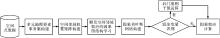
Fig. 1
The proposed strategy"
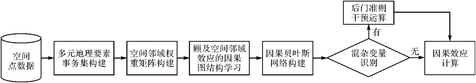
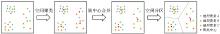
Fig. 2
Adaptive construction of spatial partitioning for transaction sets of multiple geographical elements in causal pattern mining"
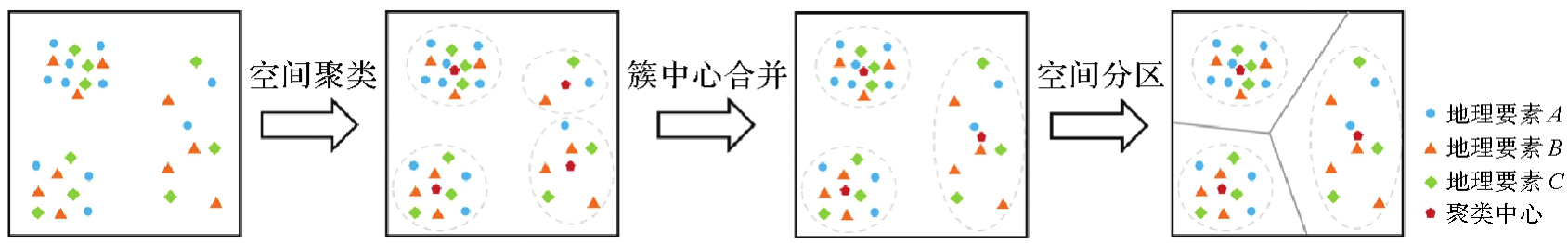
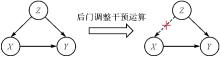
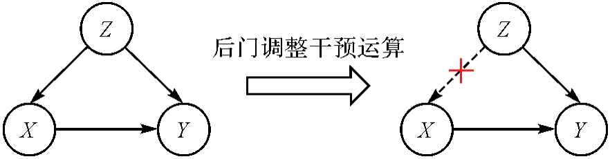
Fig. 3
The intervention operation of eliminating confounding variables' effects"
Tab. 1
Information of POI categories"
| 一级类别 | 二级类别 |
|---|---|
| 学校 | 学校(中类) |
| 餐厅 | 中餐厅、快餐厅、外国餐厅 |
| 商超 | 商场、超级市场 |
| 酒店住宿 | 宾馆酒店、住宿服务相关 |
| 公交站点 | 公交车站、地铁站 |
| 娱乐场所 | 娱乐场所(中类) |
| 运动场馆 | 运动场馆(中类) |
Tab. 2
The numbers of different types of POIs in Shenzhen"
| POI类别 | 数量 |
|---|---|
| 学校 | 74 422 |
| 餐厅 | 7717 |
| 商超 | 7547 |
| 酒店住宿 | 6453 |
| 公交站点 | 4564 |
| 娱乐场所 | 4163 |
| 运动场馆 | 3393 |
Tab. 3
The numbers of different types of POIs in Shanghai"
| POI类别 | 数量 |
|---|---|
| 学校 | 85 085 |
| 餐厅 | 17 017 |
| 商超 | 12 829 |
| 酒店住宿 | 11 076 |
| 公交站点 | 8860 |
| 娱乐场所 | 7727 |
| 运动场馆 | 7632 |
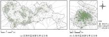
Fig. 4
The partition results of basic study units"

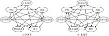
Fig. 5
Causal diagrams for the aggregation of urban functional facilities"
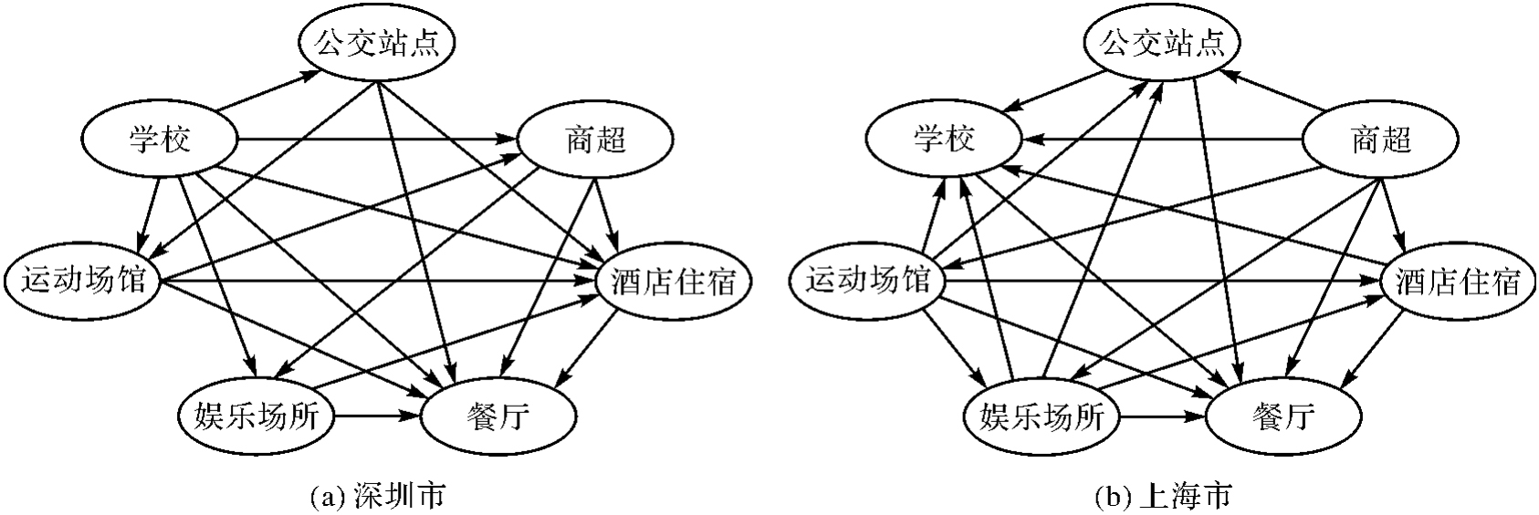
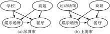
Fig. 6
Examples of causality and confounding variables of urban functional facilities aggregation"
Tab. 4
Causal effects for the aggregation of urban functional facilities in Shenzhen"
| 城市功能设施集聚因果关系 | P(Y=1|do(X=1)) | P(Y=1|do(X=0)) | 集聚因果效应 |
|---|---|---|---|
| {“商超”→“娱乐场所”} | 0.452 94 | 0.105 12 | 0.347 82 |
| {“商超”→“餐厅”} | 0.391 66 | 0.096 92 | 0.294 74 |
| {“娱乐场所”→“餐厅”} | 0.455 64 | 0.098 62 | 0.357 02 |
| {“学校”→“运动场馆”} | 0.330 69 | 0.167 54 | 0.163 15 |
| {“酒店住宿”→“餐厅”} | 0.402 28 | 0.159 99 | 0.242 29 |
| {“运动场馆”→“商超”} | 0.347 69 | 0.190 86 | 0.156 83 |
| {“运动场馆”→“餐厅”} | 0.304 39 | 0.131 00 | 0.173 39 |
Tab. 5
Causal effects for the aggregation of urban functional facilities in Shanghai"
| 城市功能设施集聚因果关系 | P(Y=1|do(X=1)) | P(Y=1|do(X=0)) | 集聚因果效应 |
|---|---|---|---|
| {“商超”→“娱乐场所”} | 0.265 02 | 0.124 44 | 0.140 58 |
| {“商超”→“餐厅”} | 0.326 75 | 0.083 29 | 0.243 46 |
| {“娱乐场所”→“酒店住宿”} | 0.160 70 | 0.048 08 | 0.112 62 |
| {“娱乐场所”→“餐厅”} | 0.377 73 | 0.112 05 | 0.265 68 |
| {“酒店住宿”→“餐厅”} | 0.333 50 | 0.151 08 | 0.182 42 |
| {“运动场馆”→“娱乐场所”} | 0.394 30 | 0.132 07 | 0.262 23 |
| {“运动场馆”→“酒店住宿”} | 0.204 80 | 0.048 65 | 0.156 15 |
| {“运动场馆”→“餐厅”} | 0.328 40 | 0.132 64 | 0.195 76 |
Fig. 7
Spatial distributions of significant causalities of functional facility aggregation in Shenzhen"
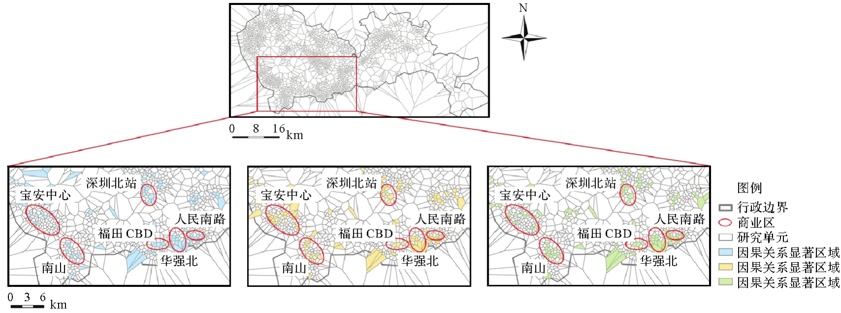
Fig. 8
Spatial distributions of significant causalities of functional facility aggregation in Shanghai"
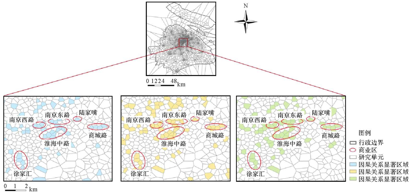

Fig. 9
The comparison of confidences between spatial association and causality patterns of urban functional facilities in Shenzhen"
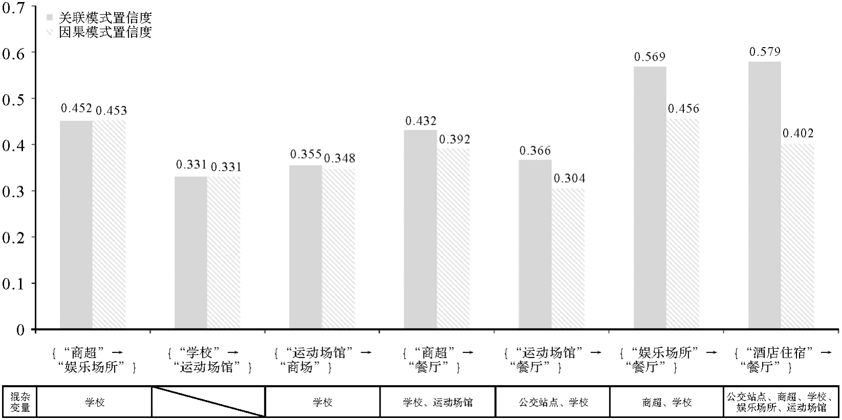
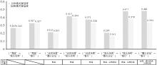
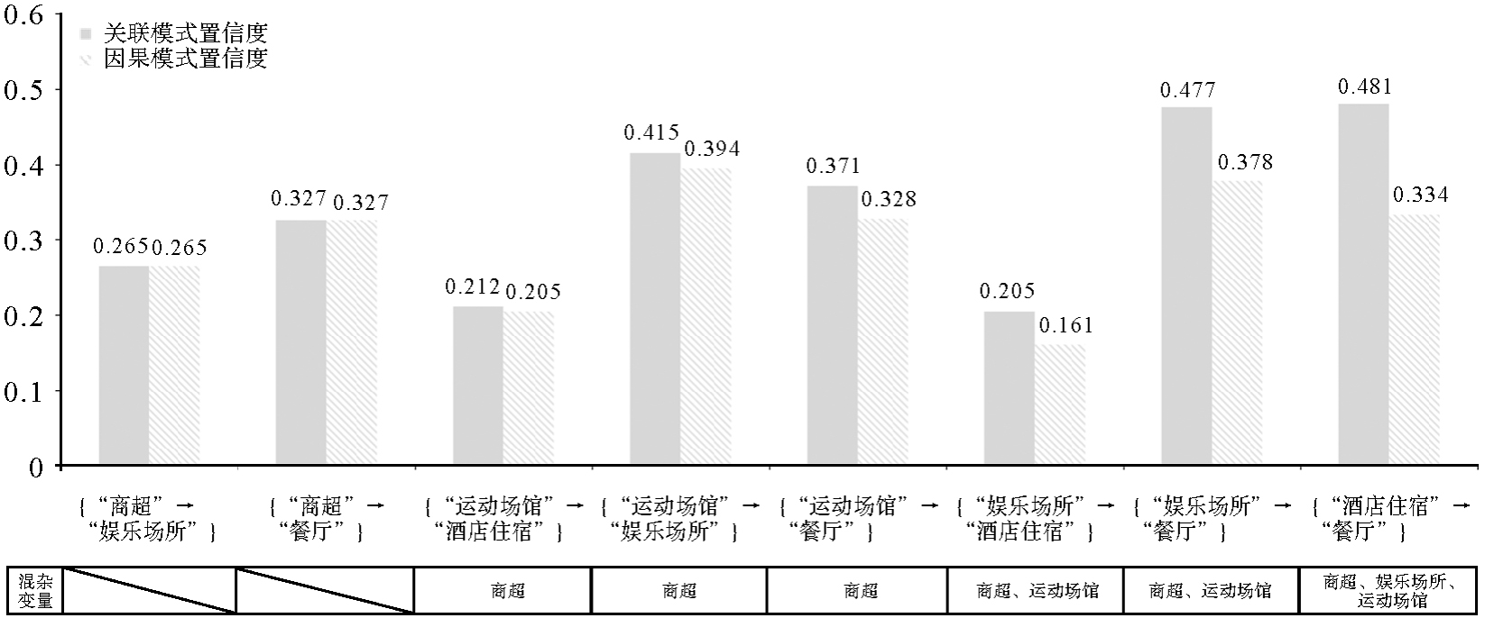
Fig. 10
The comparison of confidences between spatial association and causality patterns of urban functional facilities in Shanghai"
Tab. 6
Comparisons of causal relationships between urban functional facilities in Shanghai under different spatial distance thresholds"
| 因果关系 | 100 | 300 | 500 | 700 | 900 |
|---|---|---|---|---|---|
| {“商超”→“公交站点”} | √ | √ | √ | √ | √ |
| {“商超”→“娱乐场所”} | √ | √ | √ | ||
| {“商超”→“酒店住宿”} | √ | √ | √ | √ | |
| {“商超”→“餐厅”} | √ | √ | √ | √ | √ |
| {“商超”→“学校”} | √ | √ | √ | √ | |
| {“商超”→“运动场馆”} | √ | √ | √ | ||
| {“运动场馆”→“娱乐场所”} | √ | √ | √ | ||
| {“运动场馆”→“餐厅”} | √ | √ | √ | √ | √ |
| {“运动场馆”→“酒店住宿”} | √ | √ | √ | √ | √ |
| {“运动场馆”→“学校”} | √ | √ | √ | √ | √ |
| {“运动场馆”→“公交站点”} | √ | √ | √ | √ | |
| {“酒店住宿”→“餐厅”} | √ | √ | √ | √ | √ |
| {“酒店住宿”→“学校”} | √ | ||||
| {“娱乐场所”→“餐厅”} | √ | √ | √ | √ | √ |
| {“娱乐场所”→“酒店住宿”} | √ | √ | √ | √ | √ |
| {“娱乐场所”→“学校”} | √ | √ | √ | √ | |
| {“娱乐场所”→“公交站点”} | √ | √ | √ | √ | |
| {“公交站点”→“学校”} | √ | √ | √ | ||
| {“公交站点”→“餐厅”} | √ | √ | √ | √ | √ |
| {“学校”→“餐厅”} | √ | √ | √ | √ | √ |
| {“学校”→“公交站点”} | √ | √ | |||
| {“学校”→“酒店住宿”} | √ | √ | √ | ||
| {“公交站点”→“酒店住宿”} | √ | √ | √ |
Tab. 7
Comparison of causal relationships based on Euclidean distance and road network distance clustering in Shanghai"
| 因果关系 | 欧氏距离 | 路网距离 |
|---|---|---|
| {“商超”→“公交站点”} | √ | √ |
| {“商超”→“娱乐场所”} | √ | |
| {“商超”→“酒店住宿”} | √ | √ |
| {“商超”→“餐厅”} | √ | √ |
| {“商超”→“学校”} | √ | √ |
| {“商超”→“运动场馆”} | √ | |
| {“运动场馆”→“娱乐场所”} | √ | |
| {“运动场馆”→“餐厅”} | √ | √ |
| {“运动场馆”→“酒店住宿”} | √ | √ |
| {“运动场馆”→“学校”} | √ | √ |
| {“运动场馆”→“公交站点”} | √ | √ |
| {“酒店住宿”→“餐厅”} | √ | √ |
| {“酒店住宿”→“学校”} | √ | √ |
| {“娱乐场所”→“餐厅”} | √ | √ |
| {“娱乐场所”→“酒店住宿”} | √ | √ |
| {“娱乐场所”→“学校”} | √ | |
| {“娱乐场所”→“公交站点”} | √ | √ |
| {“学校”→“餐厅”} | √ | √ |
| {“公交站点”→“学校”} | √ | √ |
| {“公交站点”→“餐厅”} | √ | √ |
| {“公交站点”→“酒店住宿”} | √ |
| [1] |
刘耀林, 刘启亮, 邓敏, 等. 地理大数据挖掘研究进展与挑战[J]. 测绘学报, 2022, 51(7): 1544-1560. DOI .
doi: 10.11947/j.AGCS.2022.20220068 |
|
LIU Yaolin, LIU Qiliang, DENG Min, et al. Recent advance and challenge in geospatial big data mining[J]. Acta Geodaetica et Cartographica Sinica, 2022, 51(7): 1544-1560. DOI .
doi: 10.11947/j.AGCS.2022.20220068 |
|
| [2] | 邓敏, 蔡建南, 杨文涛, 等. 多模态地理大数据时空分析方法[J]. 地球信息科学学报, 2020, 22(1): 41-56. |
| DENG Min, CAI Jiannan, YANG Wentao, et al. Spatio-temporal analysis methods for multi-modal geographic big data[J]. Journal of Geo-information Science, 2020, 22(1): 41-56. | |
| [3] | SHEKHAR S, HUANG Yan. Discovering spatial co-location patterns: a summary of results[M]//Advances in spatial and temporal databases. Berlin: Springer, 2001: 236-256. |
| [4] |
蔡建南, 刘启亮, 徐枫, 等. 多层次空间同位模式自适应挖掘方法[J]. 测绘学报, 2016, 45(4): 475-485. DOI .
doi: 10.11947/j. AGCS.2016.20150337 |
|
CAI Jiannan, LIU Qiliang, XU Feng, et al. An adaptive method for mining hierarchical spatial co-location patterns[J]. Acta Geodaetica et Cartographica Sinica, 2016, 45(4): 475-485. DOI .
doi: 10.11947/j. AGCS.2016.20150337 |
|
| [5] | CAI Jiannan, LIU Qiliang, DENG Min, et al. Adaptive detection of statistically significant regional spatial co-location patterns[J]. Computers, Environment and Urban Systems, 2018, 68: 53-63. |
| [6] | 邓敏, 蔡建南, 何占军, 等. 地理空间关联模式挖掘的理论与方法[M]. 北京: 科学出版社, 2023. |
| DENG Min, CAI Jiannan, HE Zhanjun, et al. Theory and method of mining geo-spatial association patterns[M]. Beijing: Science Press, 2023. | |
| [7] | YU Wenhao, AI Tinghua, HE Yakun, et al. Spatial co-location pattern mining of facility points-of-interest improved by network neighborhood and distance decay effects[J]. International Journal of Geographical Information Science, 2017, 31(2): 280-296. |
| [8] | ANDRZEJEWSKI W, BOINSKI P. Efficient spatial co-location pattern mining on multiple GPUs[J]. Expert Systems with Applications, 2018, 93(3): 465-483. |
| [9] | CHEN Yimin, CHEN Xinyue, LIU Zihui, et al. Understanding the spatial organization of urban functions based on co-location patterns mining: a comparative analysis for 25 Chinese cities[J]. Cities, 2020, 97: 102563. |
| [10] | HE Zhanjun, DENG Min, XIE Zhong, et al. Discovering the joint influence of urban facilities on crime occurrence using spatial co-location pattern mining[J]. Cities, 2020, 99: 102612. |
| [11] | LI Ling, CHENG Jianquan, BANNISTER J, et al. Geographically and temporally weighted co-location quotient: an analysis of spatiotemporal crime patterns in greater Manchester[J]. International Journal of Geographical Information Science, 2022, 36(5): 918-942. |
| [12] | ZHI Guoqing, MENG Bin, LIN Hui, et al. Spatial co-location patterns between early COVID-19 risk and urban facilities: a case study of Wuhan, China[J]. Frontiers in Public Health, 2024, 11: 1293888. |
| [13] | BARREDO ARRIETA A, DÍAZ-RODRÍGUEZ N, DEL SER J, et al. Explainable artificial intelligence (XAI): concepts, taxonomies, opportunities and challenges toward responsible AI[J]. Information Fusion, 2020, 58: 82-115. |
| [14] | WU Chenwang, WANG Xiting, LIAN Defu, et al. A causality inspired framework for model interpretation[C]//Proceedings of the 29th ACM SIGKDD Conference on Knowledge Discovery and Data Mining. Long Beach: ACM Press, 2023: 2731-2741. |
| [15] | PEARL J. Causal inference in statistics: an overview[J]. Statistics Surveys, 2009, 3: 96-146. |
| [16] | 苏建宾, 陈都鑫, 郑东海, 等. 追索为什么?地球系统科学中的因果推理[J]. 中国科学:地球科学, 2023, 53(10): 2199-2216. |
| SU Jianbin, CHEN Dduxin, ZHENG Donghai et al. The insight of why: causal inference in Earth system science[J]. Scientia Sinica (Terrae), 2023, 53(10): 2199-2216. | |
| [17] | SPIRTES P, GLYMOUR C. An algorithm for fast recovery of sparse causal graphs[J]. Social Science Computer Review, 1991, 9(1): 62-72. |
| [18] | SHIMIZU S. Lingam: non-Gaussian methods for estimating causal structures[J]. Behaviormetrika, 2014, 41(1): 65-98. |
| [19] | ROSENBAUM P R, RUBIN D B. The central role of the propensity score in observational studies for causal effects[J]. Biometrika, 1983, 70(1): 41-55. |
| [20] | ABADIE A. Semiparametric difference-in-differences estimators[J]. The Review of Economic Studies, 2005, 72(1): 1-19. |
| [21] | PEARL J. Causality: models, reasoning, and inference[M]. Cambridge: Cambridge University Press, 2000. |
| [22] | PEARL J. Causal diagrams for empirical research[J]. Biometrika, 1995, 82(4): 669-688. |
| [23] | RUBIN D B. Estimating causal effects of treatments in randomized and nonrandomized studies[J]. Journal of Educational Psychology, 1974, 66(5): 688-701. |
| [24] | SPLAWA-NEYMAN J, DABROWSKA D M, SPEED T P. On the application of probability theory to agricultural experiments. essay on principles. section 9[J]. Statistical Science, 1990, 5(4): 465-472. |
| [25] | PEARL J. Causality[M]. Cambridge: Cambridge University Press, 2009. |
| [26] | PEARL J, GLYMOUR M, JEWELL N P. Causal inference in statistics: a primer[M]. John Wiley & Sons, 2016. |
| [27] | GRANGER C W. Investigating causal relations by econometric models and cross-spectral methods[J]. Econometrica, 1969, 37(3): 424-438. |
| [28] | GRANGER C W. Testing for causality: a personal viewpoint[J]. Journal of Economic Dynamics and Control, 1980, 2(1): 329-352. |
| [29] | SUGIHARA G, MAY R, YE Hao, et al. Detecting causality in complex ecosystems[J]. Science, 2012, 338(6106): 496-500. |
| [30] | XIAO Zhixuan, LI Chengyi, PAN Shihua, et al. Exploring the spatial impact of multisource data on urban vitality: a causal machine learning method[J]. Wireless Communications and Mobile Computing, 2022, 2022(1): 5263376. |
| [31] | CHEN Yimin, CHEN Jing, ZHAO Shuai, et al. Inferring the heterogeneous effect of urban land use on building height with causal machine learning[J]. GIScience & Remote Sensing, 2024, 61(1): 2321695. |
| [32] | CHEN Ziyue, XIE Xiaoming, CAI Jun, et al. Understanding meteorological influences on PM2.5 concentrations across China: a temporal and spatial perspective[J]. Atmospheric Chemistry & Physics, 2018, 18(8): 5343-5358. |
| [33] | GAO Bingbo, YANG Jianyu, CHEN Ziyue, et al. Causal inference from cross-sectional earth system data with geographical convergent cross mapping[J]. Nature Communications, 2023, 14(1): 5875. |
| [34] | ANKERST M, BREUING M M, KRIEGEL H P, et al. OPTICS: ordering points to identify the clustering structure[J]. ACM SIGMOD Record, 1999, 28(2): 49-60. |
| [35] | AKBARI K, WINTER S, TOMKO M. Spatial causality: a systematic review on spatial causal inference[J]. Geographical Analysis, 2023, 55(1): 56-89. |
| [36] | DIGITALE J C, MARTIN J N, GLYMOUR M M. Tutorial on directed acyclic graphs[J]. Journal of Clinical Epidemiology, 2022, 142: 264-267. |
| [37] | TENNANT P W G, MURRAY E J, ARNOLD K F, et al. Use of directed acyclic graphs (DAGs) to identify confounders in applied health research: review and recommendations[J]. International Journal of Epidemiology, 2021, 50(2): 620-632. |
| [38] | PETERS J, JANZING D, SCHÖLKOPF B. Elements of causal inference: foundations and learning algorithms[M]. Cambridge: The MIT Press, 2017. |
| [39] | ZHENG Xun, DAN Chen, ARAGAM B, et al. Learning sparse nonparametric dags[C]//Proceedings of 2020 International Conference on Artificial Intelligence and Statistics. [S.l.]: IEEE, 2020: 3414-3425. |
| [40] |
王靖涵, 艾廷华, 吴昊, 等. 基于图结构的空间同位模式挖掘[J]. 测绘学报, 2024, 53(4): 724-735. DOI .
doi: 10.11947/j. AGCS.2024.20230012 |
|
WANG Jinghan, AI Tinghua, WU Hao, et al. Spatial co-location pattern mining based on graph structure[J]. Acta Geodaetica et Cartographica Sinica, 2024, 53(4): 724-735. DOI .
doi: 10.11947/j. AGCS.2024.20230012 |
|
| [41] | YU Wenhao. Spatial co-location pattern mining for location-based services in road networks[J]. Expert Systems with Applications, 2016, 46(3): 324-335. |
| [42] | TRAN V, WANG Lizhen, CHEN Hongmei, et al. MCHT: a maximal clique and hash table-based maximal prevalent co-location pattern mining algorithm[J]. Expert Systems with Applications, 2021, 175: 114830. |
| [43] | 卢雨蓉, 邓建锋, 韩贵锋, 等. 城市公园的多维可达性动态评估研究[J]. 中国园林, 2022, 38(5): 92-97. |
| LU Yurong, DENG Jianfeng, HAN Guifeng, et al. Research on dynamic evaluation of multidimensional accessibility to urban park[J]. Chinese Landscape Architecture, 2022, 38(5): 92-97. |
| [1] | Mingguang WU, Ziming CHENG. Color generation method for green maps considering use contexts [J]. Acta Geodaetica et Cartographica Sinica, 2026, 55(3): 390-403. |
| [2] | Min YANG, Hongran MA, Bo KONG, Pengcheng LIU, Tinghua AI. A pre-trained model-based method for discriminating morphological patterns of vector-based coastlines [J]. Acta Geodaetica et Cartographica Sinica, 2026, 55(3): 404-414. |
| [3] | Wenhao YU, Ziyi ZENG, Yifan ZHANG, Haizhong QIAN. Road network grid pattern analysis using a pre-trained model fusing spatial and topological information [J]. Acta Geodaetica et Cartographica Sinica, 2026, 55(3): 415-424. |
| [4] | Xiaomin LU, Zhiyi ZHANG, Haowen YAN, Yi HE, Xiaoning SU. A recognition method for building group pattern integrating deep graph infomax and multilayer perceptron [J]. Acta Geodaetica et Cartographica Sinica, 2026, 55(3): 425-438. |
| [5] | Xiaoqiang CHENG, Jiawei ZHAO, Pengcheng LIU. Spatial interaction visualization based on the distance-similarity metaphor [J]. Acta Geodaetica et Cartographica Sinica, 2026, 55(3): 536-547. |
| [6] | Zejiao WANG, Longgang XIANG, Meng WANG, Xingjuan WANG, Qing LIU. Hierarchical feature and diversified attention fusion network for collaborative extraction of road surface and centerline [J]. Acta Geodaetica et Cartographica Sinica, 2026, 55(3): 548-563. |
| [7] | Zhibang XU. Hierarchical boundary identification, pattern analysis and expansion simulation of physical cities [J]. Acta Geodaetica et Cartographica Sinica, 2026, 55(3): 566-566. |
| [8] | Yunbo RAN, Xue YANG, Wenhao ZHOU, Chengen WU, Baoding ZHOU, Luliang TANG, Qingquan LI. Pedestrian path planning driven by preference-enhanced adversarial deep reinforcement learning [J]. Acta Geodaetica et Cartographica Sinica, 2026, 55(2): 191-205. |
| [9] | Lizeng WANG, Shifen CHENG, Yitao YANG, Peixiao WANG, Feng LU. LGA-EL: a spatio-temporal adaptive ensemble method with local-global awareness for traffic prediction [J]. Acta Geodaetica et Cartographica Sinica, 2026, 55(2): 206-221. |
| [10] | Shaohua WANG, Haojian LIANG, Cheng SU, Dachuan XU, Liang ZHOU, Kun QIN. Advances and prospects in urban facility allocation optimization through coupling spatio-temporal big data and artificial intelligence [J]. Acta Geodaetica et Cartographica Sinica, 2026, 55(2): 222-235. |
| [11] | Xiao FU, Sirui ZHU, Xudong LI, Guonian LÜ. An optimization method for the layout of urban vertiports in long-distance commuting scenarios [J]. Acta Geodaetica et Cartographica Sinica, 2026, 55(2): 236-248. |
| [12] | Junhao GUO, Mingzhi WU, Peixiao WANG, Hengcai ZHANG. A dual-threshold stay point detection method based on adaptive extended density peak clustering for sparse fixed-point trajectories [J]. Acta Geodaetica et Cartographica Sinica, 2026, 55(2): 249-260. |
| [13] | Guannan LI. Method for automatic construction of three dimensional real scene model of the road [J]. Acta Geodaetica et Cartographica Sinica, 2026, 55(2): 378-378. |
| [14] | Pengcheng LIU, Xiaoqiang CHENG, Tianyuan XIAO, Min YANG, Tinghua AI. A Transformer model for building polygon simplification in map generalization [J]. Acta Geodaetica et Cartographica Sinica, 2026, 55(1): 124-137. |
| [15] | Biao HE, Haojia LIN, Renzhong GUO, Xi KUAI, Ding MA, Chen ZHANG. Visual perception-based quantitative calculation of 3D spatial similarity relations [J]. Acta Geodaetica et Cartographica Sinica, 2026, 55(1): 138-153. |
| Viewed | ||||||
|
Full text |
|
|||||
|
Abstract |
|
|||||