

Acta Geodaetica et Cartographica Sinica ›› 2026, Vol. 55 ›› Issue (1): 138-153.doi: 10.11947/j.AGCS.2026.20250096
• Cartography and Geoinformation • Previous Articles Next Articles
Biao HE1,2,3,4( ), Haojia LIN1,2,3,4,5(), Renzhong GUO1,2,3,4, Xi KUAI2,3,4, Ding MA2,3,4, Chen ZHANG2,3,4
Received:2025-03-04
Revised:2025-12-26
Online:2026-02-13
Published:2026-02-13
Contact:
Haojia LIN
E-mail:hebiao@szu.edu.cn;linhaojia@szu.edu.cn
About author:HE Biao (1983—), male, PhD, professor, majors in smart city digital twin platform and 3D cadastral, et al. E-mail: hebiao@szu.edu.cn
Supported by:CLC Number:
Biao HE, Haojia LIN, Renzhong GUO, Xi KUAI, Ding MA, Chen ZHANG. Visual perception-based quantitative calculation of 3D spatial similarity relations[J]. Acta Geodaetica et Cartographica Sinica, 2026, 55(1): 138-153.

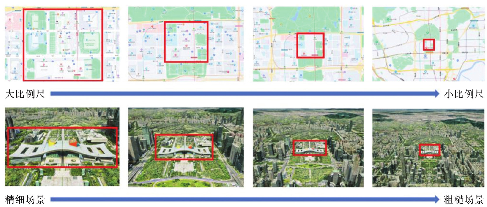
Fig. 1
Multi-scale representation of 2D and 3D spatial data"
Tab. 1
Analysis of similarities and differences between multi-scale representations of 2D and 3D spatial data"
| 类型 | 二维矢量数据 | 三维空间数据 |
|---|---|---|
| 数据性质 | 对世界的抽象描述 | 对世界的真实描述 |
| 表现形式 | 二维平面 | 三维场景 |
| 组成要素 | 二维平面中的点、线、面 | 三维空间中的点、线、面、体 |
| 信息构成 | 几何、空间关系、语义 | 几何、空间关系、语义、纹理 |
| 尺度表达 | 分尺度离散切换 | 连续尺度平滑过渡 |
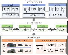
Fig. 2
Overall research framework"

Fig. 3
Perception process of 3D spatial similarity relations"
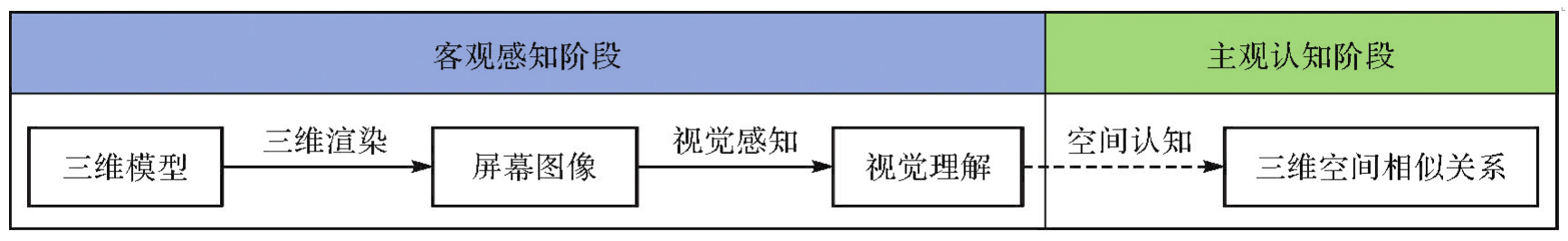
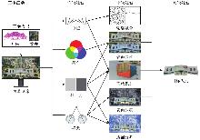
Fig. 4
Perception mechanism of 3D spatial similarity relations"
Fig. 5
Spatial transformation and quantitative representation of similarity relations perception"
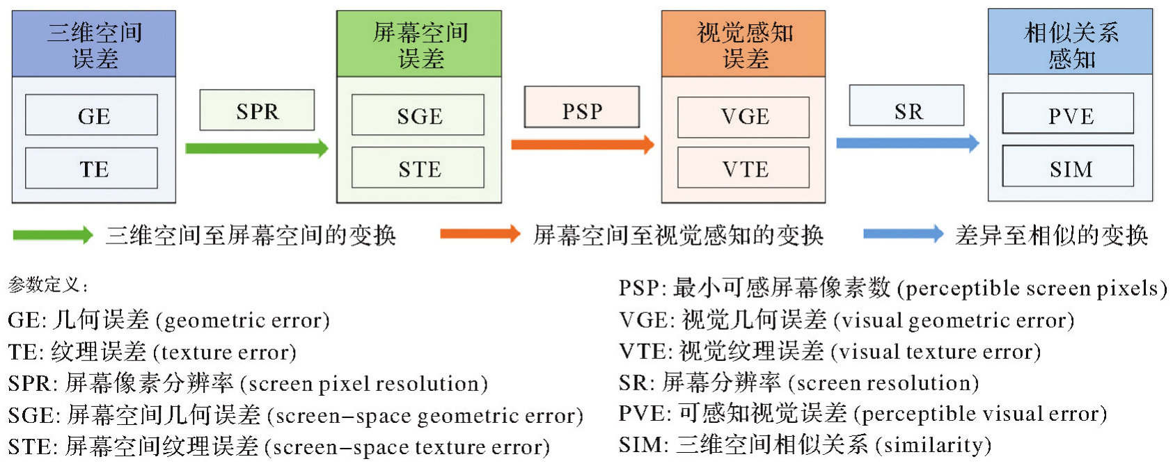
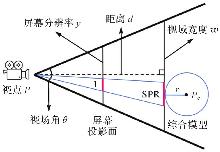
Fig. 6
Calculation principle of screen geometric pixel ratio"

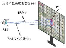
Fig. 7
Calculation principle of perceptible screen pixels"
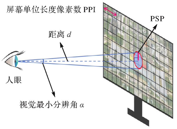
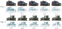
Fig. 8
Screenshots of experimental data"

Tab. 2
Experimental data information"
| 目标 | 模型 | TN | VN | TR/像素 | PR | GE | TE |
|---|---|---|---|---|---|---|---|
| 单体目标S | S0 | 4084 | 3147 | 2048×1024 | 10.572 3 | 0 | 0 |
| S1 | 2041 | 2003 | 1024×512 | 21.144 5 | 15.135 6 | 2.000 0 | |
| S2 | 1020 | 1335 | 512×256 | 42.289 1 | 30.271 2 | 4.000 0 | |
| S3 | 780 | 1094 | 256×128 | 84.578 2 | 60.542 5 | 8.000 0 | |
| S4 | 596 | 911 | 128×64 | 169.156 3 | 121.085 0 | 16.000 0 | |
| 群组目标G0 | A0 | 5400 | 16 200 | 2048×2048 | 10.460 6 | 0 | 0 |
| B0 | 6972 | 20 916 | 2048×2048 | 9.494 8 | 0 | 0 | |
| C0 | 3406 | 10 218 | 2048×1024 | 9.154 8 | 0 | 0 | |
| 群组目标G1 | A1 | 2699 | 8097 | 1024×1024 | 20.932 3 | 20.040 1 | 2.001 1 |
| B1 | 3485 | 10 455 | 1024×1024 | 18.995 5 | 20.029 7 | 2.000 6 | |
| C1 | 1703 | 5109 | 1024×512 | 18.309 6 | 14.180 4 | 2.000 0 | |
| 群组目标G2 | A2 | 1473 | 4419 | 512×512 | 41.890 1 | 40.080 2 | 4.004 6 |
| B2 | 1751 | 5253 | 512×512 | 38.012 6 | 40.059 5 | 4.003 5 | |
| C2 | 1022 | 3066 | 512×256 | 36.624 4 | 28.360 8 | 4.000 6 | |
| 群组目标G3 | A3 | 1285 | 3855 | 256×256 | 84.714 8 | 80.160 5 | 8.098 5 |
| B3 | 1534 | 4602 | 256×256 | 76.690 4 | 80.119 0 | 8.077 1 | |
| C3 | 827 | 2481 | 256×128 | 73.463 3 | 56.721 6 | 8.024 6 | |
| 群组目标G4 | A4 | 905 | 2715 | 128×128 | 170.046 7 | 160.321 0 | 16.255 9 |
| B4 | 1095 | 3285 | 128×128 | 154.351 5 | 160.238 0 | 16.256 4 | |
| C4 | 621 | 1863 | 128×64 | 147.692 3 | 113.443 1 | 16.132 8 |
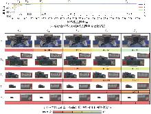
Fig. 9
Results of SIM for single targetS"

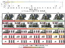
Fig. 10
Results of SIM for group targetG"

Tab. 3
SIM analysis"
| 视点 | 量化参数 | 单体目标S | 群组目标G | ||||||||
|---|---|---|---|---|---|---|---|---|---|---|---|
| S0 | S1 | S2 | S3 | S4 | G0 | G1 | G2 | G3 | G4 | ||
| V1 | SGE | 0 | 1.634 6 | 3.269 3 | 6.538 6 | 13.077 2 | 0 | 2.164 3 | 4.328 7 | 8.657 3 | 17.314 7 |
| STE | 0 | 2.283 6 | 4.567 2 | 9.134 4 | 18.268 9 | 0 | 2.260 7 | 4.524 1 | 9.149 2 | 18.365 0 | |
| VGE | 0 | 0 | 1.269 3 | 4.538 6 | 11.077 2 | 0 | 0.164 3 | 2.3287 | 6.657 3 | 15.314 7 | |
| VTE | 0 | 1.283 6 | 3.567 2 | 8.134 4 | 17.268 9 | 0 | 1.260 7 | 3.524 1 | 8.149 2 | 17.365 0 | |
| PVE | 0 | 0.001 2 | 0.004 5 | 0.011 7 | 0.026 2 | 0 | 0.001 3 | 0.005 4 | 0.013 7 | 0.030 3 | |
| SIM | 1 | 0.998 8 | 0.995 5 | 0.988 3 | 0.973 8 | 1 | 0.998 7 | 0.994 6 | 0.986 3 | 0.969 7 | |
| V2 | SGE | 0 | 0.710 7 | 1.421 4 | 2.842 9 | 5.685 7 | 0 | 0.941 0 | 1.882 0 | 3.764 1 | 7.528 1 |
| STE | 0 | 0.992 9 | 1.985 7 | 3.971 5 | 7.943 0 | 0 | 0.982 9 | 1.967 0 | 3.977 9 | 7.984 8 | |
| VGE | 0 | 0 | 0 | 0.842 9 | 3.685 7 | 0 | 0 | 0 | 1.764 1 | 5.528 1 | |
| VTE | 0 | 0 | 0.985 7 | 2.971 5 | 6.943 0 | 0 | 0 | 0.967 0 | 2.977 9 | 6.984 8 | |
| PVE | 0 | 0 | 0.000 9 | 0.003 5 | 0.009 8 | 0 | 0 | 0.000 9 | 0.004 4 | 0.011 6 | |
| SIM | 1 | 1 | 0.999 1 | 0.996 5 | 0.990 2 | 1 | 1 | 0.999 1 | 0.995 6 | 0.988 4 | |
| V3 | SGE | 0 | 0.355 4 | 0.710 7 | 1.421 4 | 2.842 9 | 0 | 0.470 5 | 0.941 0 | 1.882 0 | 3.764 1 |
| STE | 0 | 0.496 4 | 0.992 9 | 1.985 7 | 3.971 5 | 0 | 0.491 5 | 0.983 5 | 1.989 0 | 3.992 4 | |
| VGE | 0 | 0 | 0 | 0 | 0.842 9 | 0 | 0 | 0 | 0 | 1.764 1 | |
| VTE | 0 | 0 | 0 | 0.985 7 | 2.971 5 | 0 | 0 | 0 | 0.989 0 | 2.992 4 | |
| PVE | 0 | 0 | 0 | 0.000 9 | 0.003 5 | 0 | 0 | 0 | 0.000 9 | 0.004 4 | |
| SIM | 1 | 1 | 1 | 0.999 1 | 0.996 5 | 1 | 1 | 1 | 0.999 1 | 0.995 6 | |
| V4 | SGE | 0 | 0.177 7 | 0.355 4 | 0.710 7 | 1.421 4 | 0 | 0.235 3 | 0.470 5 | 0.941 0 | 1.882 0 |
| STE | 0 | 0.248 2 | 0.496 4 | 0.992 9 | 1.985 7 | 0 | 0.245 7 | 0.491 8 | 0.994 5 | 1.996 2 | |
| VGE | 0 | 0 | 0 | 0 | 0 | 0 | 0 | 0 | 0 | 0 | |
| VTE | 0 | 0 | 0 | 0 | 0.985 7 | 0 | 0 | 0 | 0 | 0.996 2 | |
| PVE | 0 | 0 | 0 | 0 | 0.000 9 | 0 | 0 | 0 | 0 | 0.000 9 | |
| SIM | 1 | 1 | 1 | 1 | 0.999 1 | 1 | 1 | 1 | 1 | 0.999 1 | |
| V5 | SGE | 0 | 0.088 8 | 0.177 7 | 0.355 4 | 0.710 7 | 0 | 0.117 6 | 0.235 3 | 0.470 5 | 0.941 0 |
| STE | 0 | 0.124 1 | 0.248 2 | 0.496 4 | 0.992 9 | 0 | 0.122 9 | 0.245 9 | 0.497 2 | 0.998 1 | |
| VGE | 0 | 0 | 0 | 0 | 0 | 0 | 0 | 0 | 0 | 0 | |
| VTE | 0 | 0 | 0 | 0 | 0 | 0 | 0 | 0 | 0 | 0 | |
| PVE | 0 | 0 | 0 | 0 | 0 | 0 | 0 | 0 | 0 | 0 | |
| SIM | 1 | 1 | 1 | 1 | 1 | 1 | 1 | 1 | 1 | 1 | |
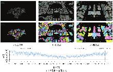
Fig. 11
The change of rendering content as viewpoint moves from far to near"

| [1] |
艾廷华, 张翔. 地理信息科学中尺度概念的诠释与表达[J]. 测绘学报, 2022, 51(7): 1640-1652. DOI: .
doi: 10.11947/j.AGCS.2022.20220143 |
|
AI Tinghua, ZHANG Xiang. An interpretation and representation of scale concept in geo-information sciences[J]. Acta Geodaetica et Cartographica Sinica, 2022, 51(7): 1640-1652. DOI: .
doi: 10.11947/j.AGCS.2022.20220143 |
|
| [2] | 褚天舒, 闫浩文, 禄小敏. 面向地图综合的道路网相似度计算模型[J]. 测绘科学, 2022, 47(1): 181-187. |
| CHU Tianshu, YAN Haowen, LU Xiaomin. A similarity calculation model of road network for map generalization[J]. Science of Surveying and Mapping, 2022, 47(1): 181-187. | |
| [3] |
高晓蓉. 顾及几何和语义相似的居民地自动综合方法[J]. 测绘学报, 2025, 54(7): 1346. DOI: .
doi: 10.11947/j.AGCS.2025.20230384 |
|
GAO Xiaorong. Automated settlement generalization methods considering geometric and semantic similarity[J]. Acta Geodaetica et Cartographica Sinica, 2025, 54(7): 1346. DOI: .
doi: 10.11947/j.AGCS.2025.20230384 |
|
| [4] | 李兆兴, 翟京生, 武芳. 线要素综合的形状相似性评价方法[J]. 武汉大学学报(信息科学版), 2019, 44(12): 1859-1864. |
| LI Zhaoxing, ZHAI Jingsheng, WU Fang. A shape similarity assessment method for linear feature generalization[J]. Geomatics and Information Science of Wuhan University, 2019, 44(12): 1859-1864. | |
| [5] | 刘鹏程, 罗静, 艾廷华, 等. 基于线要素综合的形状相似性评价模型[J]. 武汉大学学报(信息科学版), 2012, 37(1): 114-117. |
| LIU Pengcheng, LUO Jing, AI Tinghua, et al. Evaluation model for similarity based on curve generalization[J]. Geomatics and Information Science of Wuhan University, 2012, 37(1): 114-117. | |
| [6] |
禄小敏. 顾及权重信息的地图点群目标自动综合方法[J]. 测绘学报, 2024, 53(2): 398-398. DOI: .
doi: 10.11947/j.AGCS.2024.20230010 |
|
LU Xiaomin. Point cluster generalization approaches taking into account the weights of the points[J]. Acta Geodaetica et Cartographica Sinica, 2024, 53(2): 398-398. DOI: .
doi: 10.11947/j.AGCS.2024.20230010 |
|
| [7] | 郭仁忠. 空间分析[M]. 2版. 北京: 高等教育出版社, 2001. |
| GUO Renzhong. Spacial analysis[M]. 2nd ed. Beijing: Higher Education Press, 2001. | |
| [8] | DU Shihong, QIN Qimin, WANG Qiao, et al. Evaluating structural and topological consistency of complex regions with broad boundaries in multi-resolution spatial databases[J]. Information Sciences, 2008, 178(1): 52-68. |
| [9] | FORMICA A, POURABBAS E, RAFANELLI M. Constraint relaxation of the polygon-polyline topological relation for geographic pictorial query languages[J]. Computer Science and Information Systems, 2013, 10(3): 1053-1075. |
| [10] | 安晓亚, 孙群, 肖强, 等. 一种形状多级描述方法及在多尺度空间数据几何相似性度量中的应用[J]. 测绘学报, 2011, 40(4): 495-501. |
| AN Xiaoya, SUN Qun, XIAO Qiang, et al. A multi-level shape description method and its application in geometric similarity measurement of multi-scale spatial data[J]. Acta Geodaetica et Cartographica Sinica, 2011, 40(4): 495-501. | |
| [11] | 陈占龙, 徐永洋, 谢忠. 矢量面状要素几何相似性度量方法探讨[J]. 测绘科学, 2016, 41(5): 105-110. |
| CHEN Zhanlong, XU Yongyang, XIE Zhong. Discussion on geometrical similarity measurement of vector planar elements[J]. Science of Surveying and Mapping, 2016, 41(5): 105-110. | |
| [12] | 刘涛, 杜清运, 毛海辰. 空间线群目标相似度计算模型研究[J]. 武汉大学学报(信息科学版), 2012, 37(8): 992-995. |
| LIU Tao, DU Qingyun, MAO Haichen. Spatial similarity assessment model and its application in line groups[J]. Geomatics and Information Science of Wuhan University, 2012, 37(8): 992-995. | |
| [13] | 孟妮娜, 艾廷华, 周校东. 制图综合中空间关系相似度的集成表达[J]. 华中师范大学学报(自然科学版), 2009, 43(4): 693-697. |
| MENG Nina, AI Tinghua, ZHOU Xiaodong. Integrated expression of spatial relations similarity for cartographic generalization[J]. Journal of Central China Normal University (Natural Sciences), 2009, 43(4): 693-697. | |
| [14] | 王荣, 闫浩文, 禄小敏. Douglas-Peucker算法全自动化的多尺度空间相似关系方法[J]. 地球信息科学学报, 2021, 23(10): 1767-1777. |
| WANG Rong, YAN Haowen, LU Xiaomin. Automation of the Douglas-Peucker algorithm based on spatial similarity relations[J]. Journal of Geo-information Science, 2021, 23(10): 1767-1777. | |
| [15] | 宗琴, 姜树辉, 彭荃. 多尺度矢量地图数据库中模糊相似关系的图谱构建[J]. 测绘科学, 2020, 45(3): 117-121. |
| ZONG Qin, JIANG Shuhui, PENG Quan. Mapping of fuzzy similarity relation in multi-scale vector map database[J]. Science of Surveying and Mapping, 2020, 45(3): 117-121. | |
| [16] | YAN Haowen. Fundamental theories of spatial similarity relations in multi-scale map spaces[J]. Chinese Geographical Science, 2010, 20(1): 18-22. |
| [17] | 闫浩文. 空间相似关系[M]. 北京: 科学出版社, 2022. |
| YAN Haowen. Spatial similarity relation[M]. Beijing: Science Press, 2022. | |
| [18] |
闫浩文. 空间相似关系的理论体系与潜在研究方向[J]. 测绘学报, 2023, 52(11): 1962-1973. DOI: .
doi: 10.11947/j.AGCS.2023.20220695 |
|
YAN Haowen. Theoretical system and potential research issues of spatial similarity relations[J]. Acta Geodaetica et Cartographica Sinica, 2023, 52(11): 1962-1973. DOI: .
doi: 10.11947/j.AGCS.2023.20220695 |
|
| [19] | HOLT A. Spatial similarity and GIS: the grouping of spatial kinds[C]//Proceedings of the 7th Annual Colloquium of the Spatial Information Research Center. Dunedin: CiteSeer, 1999: 241-250. |
| [20] | 闫浩文, 褚衍东. 多尺度地图空间相似关系基本问题研究[J]. 地理与地理信息科学, 2009, 25(4): 42-48. |
| YAN Haowen, CHU Yandong. On the fundamental issues of spatial similarity relations in multi-scale maps[J]. Geography and Geoinformation Science, 2009, 25(4): 42-48. | |
| [21] |
林浩嘉, 郭仁忠, 贺彪, 等. 视觉感知导向的实景三维建筑场景LOD自适应可视化[J]. 测绘学报, 2025, 54(6): 1054-1070. DOI: .
doi: 10.11947/j.AGCS.2025.20240347 |
|
LIN Haojia, GUO Renzhong, HE Biao, et al. Visual-perception-oriented LOD adaptive visualization for realistic 3D building scenes[J]. Acta Geodaetica et Cartographica Sinica, 2025, 54(6): 1054-1070. DOI: .
doi: 10.11947/j.AGCS.2025.20240347 |
|
| [22] |
林浩嘉. 视觉感知驱动的三维建筑表面模型自动综合与可视化[J]. 测绘学报, 2025, 54(4): 773. DOI: .
doi: 10.11947/j.AGCS.2025.20230512 |
|
LIN Haojia. Automatic generalization and visualization of 3D building surface models driven by visual perception[J]. Acta Geodaetica et Cartographica Sinica, 2025, 54(4): 773. DOI: .
doi: 10.11947/j.AGCS.2025.20230512 |
|
| [23] | AKENINE-MOLLER T, HAINES E, HOFFMAN N. Real-time rendering, fourth edition[M]. Boca Raton: AK Peters/CRC Press, 2018. |
| [24] | KANDEL E R, SCHWARTZ J H, JESSELL T. Principles of neural science[M]. 5th ed. New York: McGraw-hill, 2013. |
| [25] | KASCHKE M, DONNERHACKE K H, RILL M S. Optical devices in ophthalmology and optometry: technology, design principles and clinical applications[M]. Weinheim: Wiley, 2014. |
| [1] | Nina MENG, Fengmei LI, Xiaodong ZHOU. Data and cognition dual-driven building group generalization results and scale consistency assessment [J]. Acta Geodaetica et Cartographica Sinica, 2025, 54(7): 1318-1331. |
| [2] | Haojia LIN, Renzhong GUO, Biao HE, Xi KUAI, Ding MA, Chengpeng LI. Visual-perception-oriented LOD adaptive visualization for realistic 3D building scenes [J]. Acta Geodaetica et Cartographica Sinica, 2025, 54(6): 1054-1070. |
| [3] | Zhanlong CHEN, Xiechun LU, Yongyang XU. A building aggregation method based on deep clustering of graph vertices [J]. Acta Geodaetica et Cartographica Sinica, 2024, 53(4): 736-749. |
| [4] | Piao LUO, Junkui XU, Fang WU, Yakun LÜ, Qingwen ZHUANG. A generative neural network method for road simplification [J]. Acta Geodaetica et Cartographica Sinica, 2024, 53(10): 2007-2020. |
| [5] | YAN Haowen. Theoretical system and potential research issues of spatial similarity relations [J]. Acta Geodaetica et Cartographica Sinica, 2023, 52(11): 1962-1973. |
| [6] | WANG Andong, WU Fang, GONG Xianyong, ZHAI Renjian, LIU Chengyi, QIU Yue, ZHANG Hanxue. A recognition approach for compound grid pattern of urban road networks [J]. Acta Geodaetica et Cartographica Sinica, 2023, 52(11): 1994-2006. |
| [7] | AI Tinghua, ZHANG Xiang. An interpretation and representation of scale concept in geo-information sciences [J]. Acta Geodaetica et Cartographica Sinica, 2022, 51(7): 1640-1652. |
| [8] | YU Yangyang, HE Kangjie, WU Fang, XU Junkui. Graph convolution neural network method for shape classification of areal settlements [J]. Acta Geodaetica et Cartographica Sinica, 2022, 51(11): 2390-2402. |
| [9] | XING Ruixing, WU Fang, GONG Xianyong, DU Jiawei, LIU Chengyi. The template matching approach to combined collinear pattern recognition in building groups [J]. Acta Geodaetica et Cartographica Sinica, 2021, 50(6): 800-811. |
| [10] | LIU Chengyi, WU Fang, GONG Xianyong, XING Ruixing, DU Jiawei. An aggregation index clustering method of natural polygon features for spatial knowledge mining [J]. Acta Geodaetica et Cartographica Sinica, 2021, 50(4): 544-555. |
| [11] | LIU Pengcheng, XIAO Tianyuan, XIAO Jia, AI Tinghua. A Head-Tail information break method oriented to multi-scale representation of polyline [J]. Acta Geodaetica et Cartographica Sinica, 2020, 49(7): 921-933. |
| [12] | LIU Zhendong, DAI Zhaoxin, LI Chengming, LIU Xiaoli. A fast fusion object determination method for multi-path video and three-dimensional GIS scene [J]. Acta Geodaetica et Cartographica Sinica, 2020, 49(5): 632-643. |
| [13] | LIU Chengyi, WU Fang, GONG Xianyong, XING Ruixing, LUO Denghan. Complex linear pattern recognition for regular pond groups [J]. Acta Geodaetica et Cartographica Sinica, 2020, 49(2): 256-266. |
| [14] | ZHANG Lihua, TANG Lulu, JIA Shuaidong, DAI Zeyuan. A collaborative simplification method for multiple coastlines based on the hierarchical triangulation network partition [J]. Acta Geodaetica et Cartographica Sinica, 2019, 48(4): 520-531. |
| [15] | DU Jiawei, WU Fang, LI Jinghan, XING Ruixing, GONG Xianyong. A Progressive Simplification Method for the Estuary Coastline [J]. Acta Geodaetica et Cartographica Sinica, 2018, 47(4): 547-556. |
| Viewed | ||||||
|
Full text |
|
|||||
|
Abstract |
|
|||||