

Acta Geodaetica et Cartographica Sinica ›› 2026, Vol. 55 ›› Issue (6): 1058-1071.doi: 10.11947/j.AGCS.2026.20260085
• Geodesy and Navigation • Previous Articles
Huacan HU1( ), Jianjun ZHU1(), Haiqiang FU1, Qijin HAN2, Aichun WANG2, Mingxia ZHANG2, Zhiwei LI1
Received:2026-03-11
Revised:2026-05-06
Published:2026-07-28
Contact:
Jianjun ZHU
E-mail:csuhuacan@csu.edu.cn;zjj@csu.edu.cn
About author:HU Huacan (2000—), male, PhD candidate, majors in forest height and sub-canopy topography estimation based on InSAR technology. E-mail: csuhuacan@csu.edu.cn
Supported by:CLC Number:
Huacan HU, Jianjun ZHU, Haiqiang FU, Qijin HAN, Aichun WANG, Mingxia ZHANG, Zhiwei LI. LT-1 sub-canopy topography inversion based on sub-aperture decomposition and LSC-block adjustment model[J]. Acta Geodaetica et Cartographica Sinica, 2026, 55(6): 1058-1071.
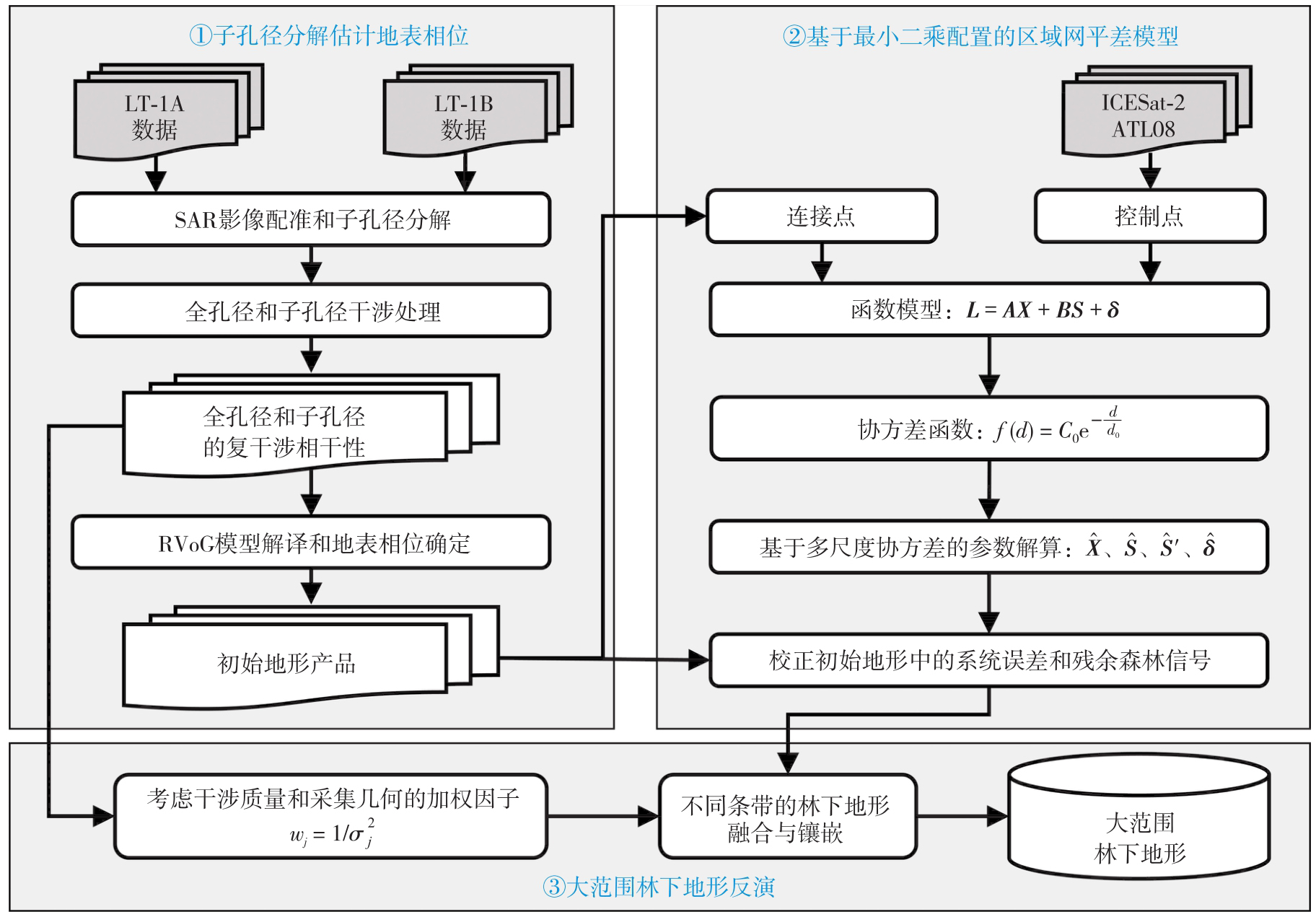
Fig. 1
Sub-canopy topography inversion framework based on sub-aperture decomposition and LSC-block adjustment model"

Tab. 1
Parameter information of LT-1 InSAR data"
| 试验区 | 获取时间 | 入射角/(°) | 有效基线/m | 模糊高/m | 轨道 | 数量 |
|---|---|---|---|---|---|---|
| 广州 | 2022-10-10 | 32.18 | 1551.29 | 61.05 | 升轨 | 5 |
| 2022-11-03 | 37.32 | 1482.61 | 70.68 | 升轨 | 5 | |
| 2022-11-11 | 40.05 | 1423.67 | 80.13 | 升轨 | 5 | |
| 2022-11-18 | 20.79 | 1853.98 | 30.01 | 升轨 | 5 | |
| 根河 | 2022-09-19 | 29.82 | 1361.79 | 58.87 | 升轨 | 2 |
| 2022-10-05 | 39.93 | 609.26 | 162.39 | 升轨 | 3 | |
| 2022-10-11 | 36.18 | 2052.88 | 48.28 | 降轨 | 3 | |
| 2022-11-11 | 41.92 | 2040.65 | 58.22 | 降轨 | 5 | |
| 2022-11-20 | 22.39 | 1994.55 | 30.93 | 降轨 | 4 | |
| 2022-11-22 | 32.76 | 727.58 | 122.49 | 升轨 | 3 | |
| 2022-11-28 | 32.93 | 2091.18 | 42.67 | 降轨 | 5 |
Fig. 2
Test site and test data coverage"
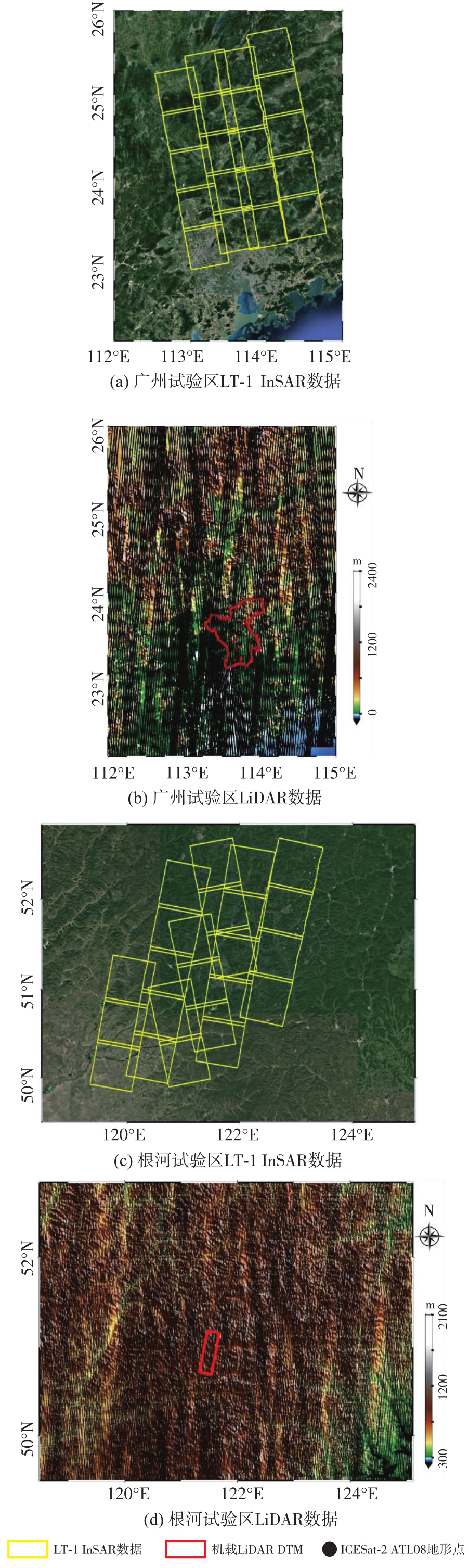
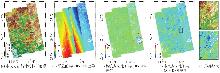
Fig. 3
Overall results of the Guangzhou test site"
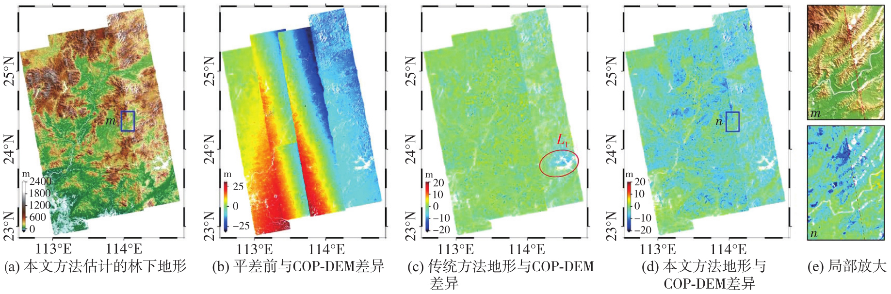
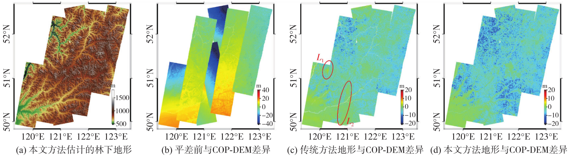
Fig. 4
Overall results of the Genhe test site"
Tab. 2
Using ICESat-2 to assess terrain accuracy in two test sites"
| 地形产品 | 广州试验区 | 根河试验区 | ||||
|---|---|---|---|---|---|---|
| MAE | STD | RMSE | MAE | STD | RMSE | |
| LT-1 DEM | 3.41 | 4.47 | 5.62 | 4.06 | 2.63 | 4.83 |
| 林下地形 | 0.31 | 3.17 | 3.19 | 0.04 | 1.37 | 1.38 |
Fig. 5
Comparison of local results in the Guangzhou test site"
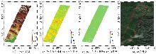
Fig. 6
Comparison of local results in the Genhe test site"
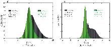
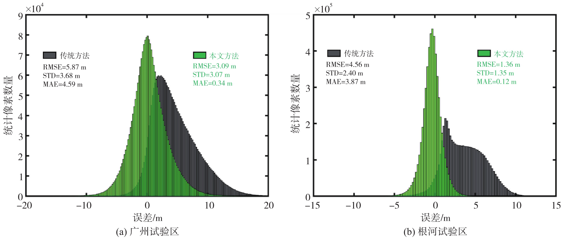
Fig. 7
Accuracy statistics using LiDAR DTM as reference"
Tab. 3
Accuracy of sub-canopy topography estimated by different methods"
| 方法 | 广州试验区 | 根河试验区 | ||||
|---|---|---|---|---|---|---|
| MAE | STD | RMSE | MAE | STD | RMSE | |
| 传统方法 | 4.59 | 3.67 | 5.87 | 3.87 | 2.40 | 4.56 |
| 本文方法(单一尺度协方差) | 0.46 | 3.58 | 3.61 | 0.25 | 1.52 | 1.54 |
| 本文方法(多尺度协方差) | 0.34 | 3.07 | 3.09 | 0.12 | 1.35 | 1.36 |
Tab. 4
Accuracy evaluation of different terrain products"
| 地形产品 | 广州试验区 | 根河试验区 | ||||||||||
|---|---|---|---|---|---|---|---|---|---|---|---|---|
| ICESat-2全局验证 | LiDAR DTM局部验证 | ICESat-2全局验证 | LiDAR DTM局部验证 | |||||||||
| MAE | STD | RMSE | MAE | STD | RMSE | MAE | STD | RMSE | MAE | STD | RMSE | |
| SRTM DEM | 3.72 | 6.26 | 7.28 | 1.19 | 6.30 | 6.41 | 2.47 | 3.09 | 3.96 | 3.32 | 2.43 | 4.12 |
| COP DEM | 3.94 | 4.62 | 6.07 | 4.91 | 4.25 | 6.49 | 5.56 | 3.56 | 6.60 | 5.48 | 3.59 | 6.55 |
| LT-1 DEM(传统方法) | 3.35 | 4.28 | 5.44 | 4.52 | 3.58 | 5.76 | 4.01 | 2.58 | 4.76 | 3.82 | 2.37 | 4.50 |
| FAB DEM | 0.54 | 3.97 | 4.01 | 0.08 | 3.88 | 3.89 | 0.39 | 2.15 | 2.19 | 0.06 | 2.57 | 2.58 |
| 林下地形(本文方法) | 0.29 | 3.15 | 3.16 | 0.31 | 3.02 | 3.04 | 0.04 | 1.35 | 1.35 | 0.11 | 1.34 | 1.35 |
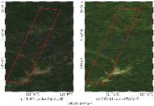
Fig. 8
Multi-temporal optical images acquired in the same season across different years in the Genhe test site"
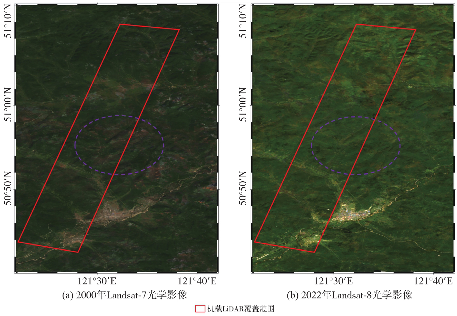
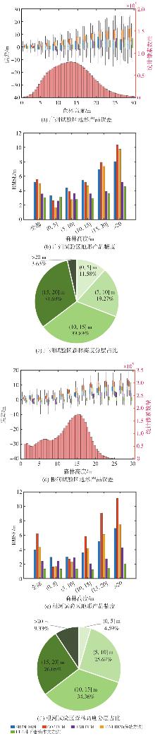
Fig. 9
Terrain error distribution and accuracy in different forest height intervals"
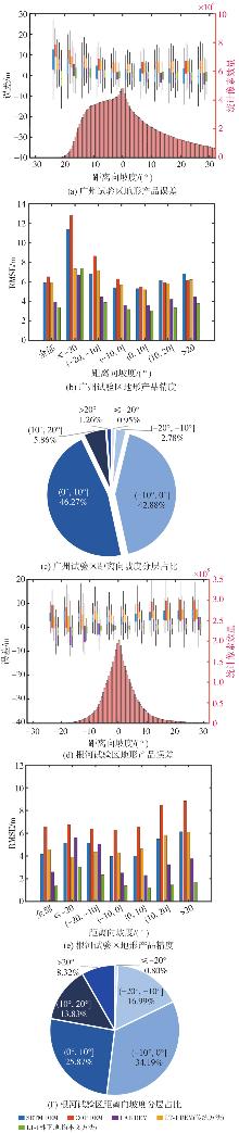
Fig. 10
Terrain error distribution and accuracy in different slope intervals"
| [1] | 朱建军, 付海强, 汪长城. InSAR林下地形测绘方法与研究进展[J]. 武汉大学学报(信息科学版), 2018, 43(12): 2030-2038. |
| ZHU Jianjun, FU Haiqiang, WANG Changcheng. Methods and research progress of underlying topography estimation over forest areas by InSAR[J]. Geomatics and Information Science of Wuhan University, 2018, 43(12): 2030-2038. | |
| [2] |
朱建军, 付海强, 汪长城. 极化干涉SAR地表覆盖层“穿透测绘”技术进展[J]. 测绘学报, 2022, 51(6): 983-995. DOI: .
doi: 10.11947/j.AGCS.2022.20220154 |
|
ZHU Jianjun, FU Haiqiang, WANG Changcheng. Research progress of “penetration mapping” of earth surface by PolInSAR[J]. Acta Geodaetica et Cartographica Sinica, 2022, 51(6): 983-995. DOI: .
doi: 10.11947/j.AGCS.2022.20220154 |
|
| [3] | RIZZOLI P, MARTONE M, GONZALEZ C, et al. Generation and performance assessment of the global TanDEM-X digital elevation model[J]. ISPRS Journal of Photogrammetry and Remote Sensing, 2017, 132: 119-139. |
| [4] | OKOLIE C J, MILLS J P, ADELEKE A K, et al. Assessment of the global Copernicus, NASADEM, ASTER and AW3D digital elevation models in Central and Southern Africa[J]. Geo-spatial Information Science, 2024, 27(4): 1362-1390. |
| [5] |
唐新明, 李涛, 张祥, 等. L波段差分干涉SAR卫星在轨应用关键参数测试分析[J]. 测绘学报, 2024, 53(10): 1863-1872. DOI: .
doi: 10.11947/j.AGCS.2024.20230240 |
|
TANG Xinming, LI Tao, ZHANG Xiang, et al. In-orbit application parameters test and analysis of L-band differential interferometric SAR satellite constellation[J]. Acta Geodaetica et Cartographica Sinica, 2024, 53(10): 1863-1872. DOI: .
doi: 10.11947/j.AGCS.2024.20230240 |
|
| [6] | TANG Xinming, LI Tao, CHEN Junli, et al. Twin-satellite constellation design and realization for terrain mapping and deformation monitoring: LuTan-1[J]. IEEE Transactions on Geoscience and Remote Sensing, 2025, 63: 5214014. |
| [7] | WANG R, LIU Kaiyu, LIU Dacheng, et al. LuTan-1: an innovative L-band spaceborne bistatic interferometric synthetic aperture radar mission[J]. IEEE Geoscience and Remote Sensing Magazine, 2025, 13(2): 58-78. |
| [8] | CLOUDE S R. Polarisation: applications in remote sensing[M/OL]. London: Oxford University Press, 2009[2026-02-11]. https://doi.org/10.1093/acprof:oso/9780199569731.001.0001. |
| [9] | PARDINI M, CAZCARRA-BES V, PAPATHANASSIOU K P. TomoSAR mapping of 3D forest structure: contributions of L-band configurations[J]. Remote Sensing, 2021, 13(12): 2255. |
| [10] | TREUHAFT R, LEI Yang, GONÇALVES F, et al. Tropical-forest structure and biomass dynamics from TanDEM-X radar interferometry[J]. Forests, 2017, 8(8): 277. |
| [11] | LEI Yang, LI Weiliang, YU Yanghai, et al. First demonstration of spaceborne L-band bistatic single-polarization single-baseline SAR interferometry on the retrieval of forest vertical structural information[J]. Remote Sensing of Environment, 2025, 329: 114916. |
| [12] | WANG Huiqiang, FU Haiqiang, ZHU Jianjun, et al. Estimation of subcanopy topography based on single-baseline TanDEM-X InSAR data[J]. Journal of Geodesy, 2021, 95(7): 84. |
| [13] | LIU Zhiwei, ZHU Jianjun, LOPEZ-SANCHEZ J M, et al. Simultaneous estimation of subcanopy topography and forest height with single-baseline single-polarization TanDEM-X interferometric data combined with ICESat-2 data[J]. IEEE Journal of Selected Topics in Applied Earth Observations and Remote Sensing, 2024, 17: 11598-11617. |
| [14] | HU Huacan, ZHU Jianjun, FU Haiqiang, et al. Automated estimation of sub-canopy topography combined with single-baseline single-polarization TanDEM-X InSAR and ICESat-2 data[J]. Remote Sensing, 2024, 16(7): 1155. |
| [15] | GARESTIER F, DUBOIS-FERNANDEZ P C, CHAMPION I. Forest height inversion using high-resolution P-band Pol-InSAR data[J]. IEEE Transactions on Geoscience and Remote Sensing, 2008, 46(11): 3544-3559. |
| [16] | FU Haiqiang, ZHU Jianjun, WANG Changcheng, et al. Underlying topography estimation over forest areas using single-baseline InSAR data[J]. IEEE Transactions on Geoscience and Remote Sensing, 2019, 57(5): 2876-2888. |
| [17] | ZHU Jianjun, XIE Yanzhou, FU Haiqiang, et al. Digital terrain, surface, and canopy height model generation with dual-baseline low-frequency InSAR over forest areas[J]. Journal of Geodesy, 2023, 97(11): 100. |
| [18] | 胡华参, 朱建军, 付海强, 等. LT-1双站InSAR林下地形测绘方法研究[J/OL]. 武汉大学学报(信息科学版), 1-19[2026-02-11]. https://doi.org/10.13203/j.whugis20250078. |
| HU Huacan, ZHU Jianjun, FU Haiqiang, et al. Research on sub-canopy topography mapping method based on LT-1 bistatic InSAR system[J/OL]. Geomatics and Information Science of Wuhan University, 1-19[2026-02-11]. https://doi.org/10.13203/j.whugis20250078. | |
| [19] | HU Huacan, FU Haiqiang, ZHU Jianjun, et al. Sub-canopy topography estimation based on sub-aperture decomposition and least-squares collocation from LuTan-1 InSAR data[J]. Journal of Geodesy, 2026, 100(1): 5. |
| [20] |
吴可夫, 付海强, 朱建军, 等. 顾及森林区穿透深度影响的LT-1 InSAR区域网平差[J]. 测绘学报, 2025, 54(6): 1009-1020. DOI: .
doi: 10.11947/j.AGCS.2025.20240426 |
|
WU Kefu, FU Haiqiang, ZHU Jianjun, et al. LT-1 InSAR block adjustment considering the impact of penetration depth in forest areas[J]. Acta Geodaetica et Cartographica Sinica, 2025, 54(6): 1009-1020. DOI: .
doi: 10.11947/j.AGCS.2025.20240426 |
|
| [21] | WESSEL B, GRUBER A, GONZALEZ J H, et al. TanDEM-X: DEM calibration concept[C]//Proceedings of 2008 IEEE International Geoscience and Remote Sensing Symposium. Boston: IEEE, 2008: 111-114. |
| [22] | GRUBER A, WESSEL B, HUBER M, et al. Operational TanDEM-X DEM calibration and first validation results[J]. ISPRS Journal of Photogrammetry and Remote Sensing, 2012, 73: 39-49. |
| [23] | TREUHAFT R N, MADSEN S N, MOGHADDAM M, et al. Vegetation characteristics and underlying topography from interferometric radar[J]. Radio Science, 1996, 31(6): 1449-1485. |
| [24] | JARMOŁOWSKI W, BAKUŁA M. Two covariance models in least squares collocation (LSC) tested in interpolation of local topography[J]. Contributions to Geophysics and Geodesy, 2013, 43(1): 1-19. |
| [25] | KOCH K R. Least squares adjustment and collocation[J]. Bulletin Géodésique, 1977, 51(2): 127-135. |
| [26] | LI Yi, FU Haiqiang, ZHU Jianjun, et al. A method for SRTM DEM elevation error correction in forested areas using ICESat-2 data and vegetation classification data[J]. Remote Sensing, 2022, 14(14): 3380. |
| [27] | KARRA K, KONTGIS C, STATMAN-WEIL Z, et al. Global land use/land cover with Sentinel 2 and deep learning[C]//Proceedings of 2021 IEEE International Geoscience and Remote Sensing Symposium IGARSS. Brussels: IEEE, 2021: 4704-4707. |
| [28] | WERNER M. Shuttle radar topography mission (SRTM) mission overview[J]. Frequenz, 2001, 55(3/4): 75-79. |
| [29] | MEADOWS M, JONES S, REINKE K. Vertical accuracy assessment of freely available global DEMs (FABDEM, Copernicus DEM, NASADEM, AW3D30 and SRTM) in flood-prone environments[J]. International Journal of Digital Earth, 2024, 17(1): 2308734. |
| [30] | YE Zilin, LONG Jiangping, ZHANG Tingchen, et al. L-band synthetic aperture radar and its application for forest parameter estimation, 1972 to 2024: a review[J]. Plants, 2024, 13(17): 2511. |
| [31] | TOUTIN T. Impact of terrain slope and aspect on radargrammetric DEM accuracy[J]. ISPRS Journal of Photogrammetry and Remote Sensing, 2002, 57(3): 228-240. |
| [32] | LI Yi, GAO Shijuan, ZHU Jianjun, et al. A gradient-constrained morphological operation for retrieving subcanopy topography over densely forested areas from ICESat-2/ATL03 data[J]. IEEE Transactions on Geoscience and Remote Sensing, 2024, 62: 4408213. |
| [33] | LI Guoyuan, YE Fanghong, TANG Xinming, et al. Influence of range gate width on detection probability and ranging accuracy of single photon laser altimetry satellite[J]. Journal of Geodesy and Geoinformation Science, 2020, 3(2): 36-44. |
| [34] | ABDEL-MAKSOUD H, AZIZ T A, ELSHARKAWY A S, et al. Advanced techniques for precision assessment in UAV LiDAR systems[J]. Journal of Geodesy and Geoinformation Science, 2025, 8(2): 90-107. |
| [1] | Kefu WU, Haiqiang FU, Jianjun ZHU, Qijin HAN, Aichun WANG, Mingxia ZHANG, Zhiwei LI. LT-1 InSAR block adjustment considering the impact of penetration depth in forest areas [J]. Acta Geodaetica et Cartographica Sinica, 2025, 54(6): 1009-1020. |
| [2] | Jun ZHU, Wei PENG, Haiqiang FU, Man OU, Shancheng LEI, Shiping ZHANG. Large-scale TanDEM-X InSAR sub-canopy topography inversion under insufficient observation information [J]. Acta Geodaetica et Cartographica Sinica, 2024, 53(5): 959-966. |
| [3] | Yunkai DENG, Yu WANG, Kaiyu LIU, Naiming OU, Dacheng LIU, Heng ZHANG, Jili WANG. Key technologies for spaceborne SAR payload of LuTan-1 satellite system [J]. Acta Geodaetica et Cartographica Sinica, 2024, 53(10): 1881-1895. |
| [4] | LI Xin, JIANG Boyang, WANG Taoyang, ZHANG Guo, CUI Hao, CHENG Qian. Geometric positioning accuracy improvement method without ground control points for global orthorectification of GF-3 [J]. Acta Geodaetica et Cartographica Sinica, 2023, 52(11): 1929-1940. |
| [5] | ZHANG Li, LIU Yuxuan, SUN Yangjie, LAN Chaozhen, AI Haibin, FAN Zhongli. A review of developments in the theory and technology of three-dimensional reconstruction in digital aerial photogrammetry [J]. Acta Geodaetica et Cartographica Sinica, 2022, 51(7): 1437-1457. |
| [6] | WU Yang, ZHANG Yongsheng, LI Kai, YU Ying, LAI Guangling. Block adjustment of satellite imagery with line-of-sight vector rectification [J]. Acta Geodaetica et Cartographica Sinica, 2021, 50(1): 85-96. |
| [7] | HAN Jie, TAO Zui, XIE Yong, LIU Qiyue, SHI Hongbin. Radiometric cross-calibration of GF-4 satellite PMS sensor considering the characteristics of multiple integration times [J]. Acta Geodaetica et Cartographica Sinica, 2020, 49(10): 1311-1320. |
| [8] | CAO Hui, TAO Pengjie, LI Haihong, ZHANG Zuxun. Using DEM as full controls in block adjustment of satellite imagery [J]. Acta Geodaetica et Cartographica Sinica, 2020, 49(1): 79-91. |
| [9] | WANG Jin, ZHANG Yong, ZHANG Zuxun, LI Xiao, TAO Pengjie, SONG Mengxiao. ICESat Laser Points Assisted Block Adjustment for Mapping Satellite-1 Stereo Imagery [J]. Acta Geodaetica et Cartographica Sinica, 2018, 47(3): 359-369. |
| [10] | WANG Tao, ZHANG Yan, ZHANG Yongsheng, MO Delin, ZHOU Liya. Investigation on GNSS Lever Arms and IMU Boresight Misalignment Calibration of Domestic Airborne Wide-field Three CCD Camera [J]. Acta Geodaetica et Cartographica Sinica, 2018, 47(11): 1474-1486. |
| [11] | YANG Bo, WANG Mi, PI Yingdong. Block-adjustment without GCPs for Large-scale Regions only Based on the Virtual Control Points [J]. Acta Geodaetica et Cartographica Sinica, 2017, 46(7): 874-881. |
| [12] | ZHENG Maoteng, ZHANG Yongjun, ZHU Junfeng, XIONG Xiaodong, ZHOU Shunping. A Fast and Effective Block Adjustment Method with Big Data [J]. Acta Geodaetica et Cartographica Sinica, 2017, 46(2): 188-197. |
| [13] | HAN Jie, XIE Yong. On-orbit Radiometric Calibration Method of Spaceborne Multi-camera Mosaic Imaging Sensor [J]. Acta Geodaetica et Cartographica Sinica, 2017, 46(11): 1830-1840. |
| [14] | GONG Jianya, WANG Mi, YANG Bo. High-precision Geometric Processing Theory and Method of High-resolution Optical Remote Sensing Satellite Imagery without GCP [J]. Acta Geodaetica et Cartographica Sinica, 2017, 46(10): 1255-1261. |
| [15] | XIONG Xin, JIN Guowang, ZHANG Hongmin, XU Qing. Application of Variance Components Estimation in Airborne InSAR Block Adjustment [J]. Acta Geodaetica et Cartographica Sinica, 2016, 45(5): 592-600. |
| Viewed | ||||||
|
Full text |
|
|||||
|
Abstract |
|
|||||
