
Acta Geodaetica et Cartographica Sinica ›› 2026, Vol. 55 ›› Issue (9): 1695-1705.doi: 10.11947/j.AGCS.2026.20260139
• Cartography and Geographic Information • Previous Articles Next Articles
Runze Chai1,2,3( ), Jingzhong Li1,2,3(), Haowen Yan1,2,3, Xiaolong Wang1,2,3, Zhenyue Liu1,2,3, Ling Wang1,2,3
Received:2026-04-13
Revised:2026-08-14
Online:2026-10-28
Published:2026-10-28
Contact:
Jingzhong Li
E-mail:12242158@stu.lzjtu.edu.cn;lilideyx@126.com
About author:Chai Runze (2002—), male, postgraduate, majors in map generalization and intelligent cartography. E-mail: 12242158@stu.lzjtu.edu.cn
Supported by:CLC Number:
Runze Chai, Jingzhong Li, Haowen Yan, Xiaolong Wang, Zhenyue Liu, Ling Wang. A graph Transformer method for river network pattern recognition incorporating three-dimensional terrain features[J]. Acta Geodaetica et Cartographica Sinica, 2026, 55(9): 1695-1705.
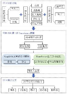
Fig. 1
Flowchart of the graph Transformer method for river network pattern recognition incorporating three-dimensional terrain features"

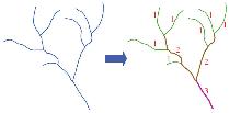
Fig. 2
River network Strahler ordering"
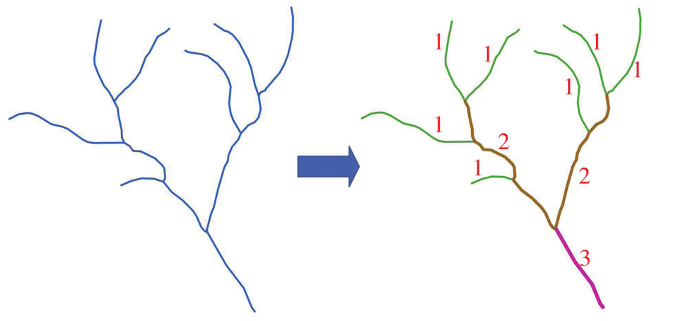
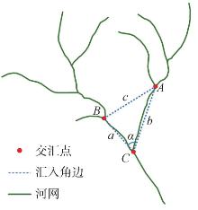
Fig. 3
River network confluence angle"
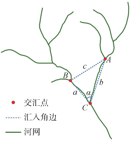
Fig. 4
Three-dimensional terrain river"
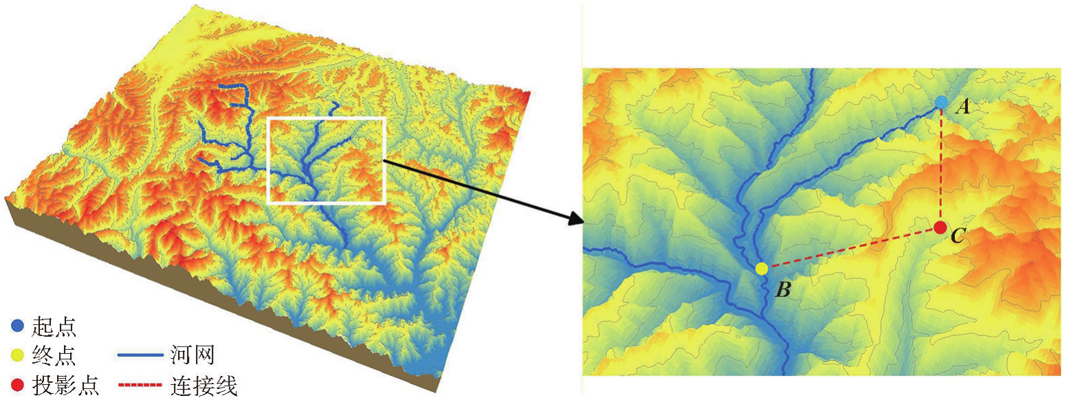
Fig. 5
Construction process of the river network dual graph"
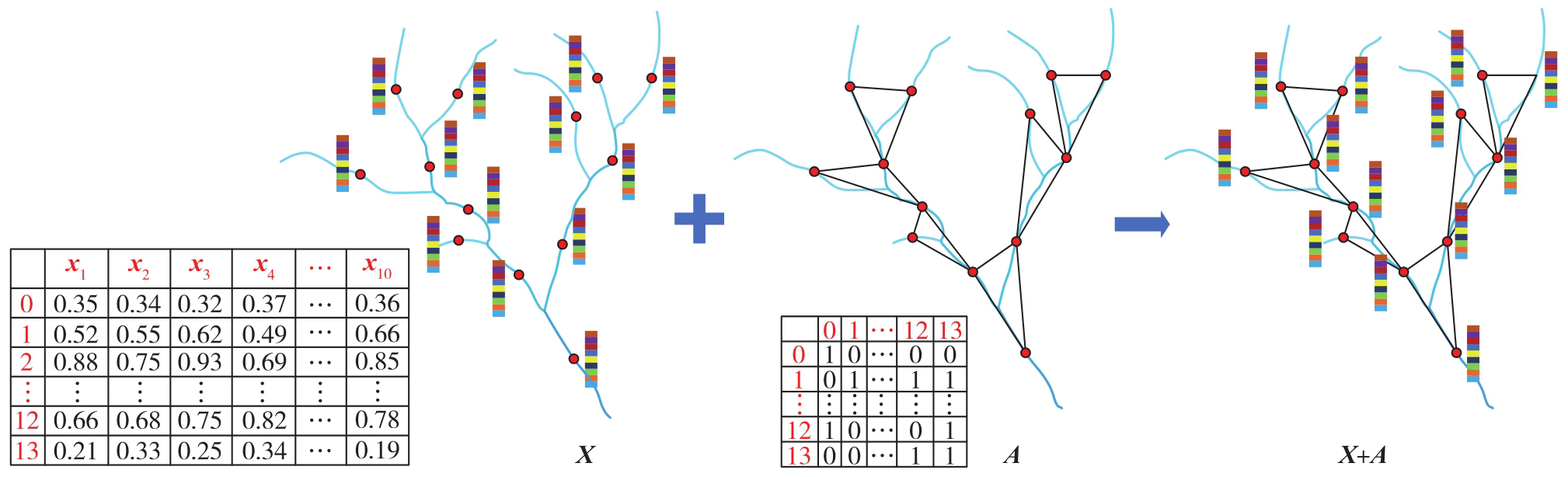
Fig. 6
Model architecture of graph Transformer-based river network pattern recognition incorporating three-dimensional terrain features"
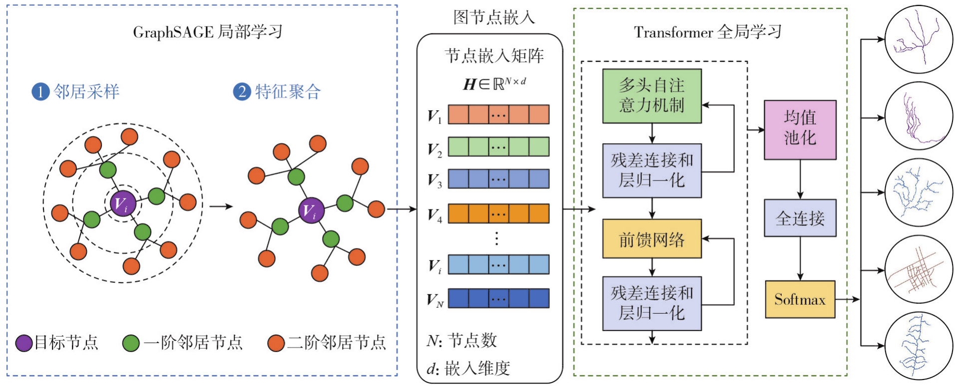
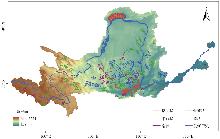
Fig. 7
Example of typical river network pattern samples in the Yellow River Basin"
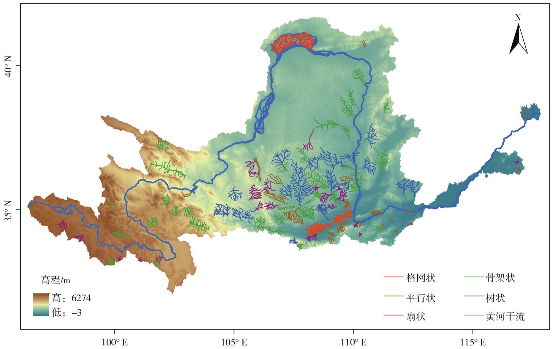
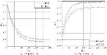
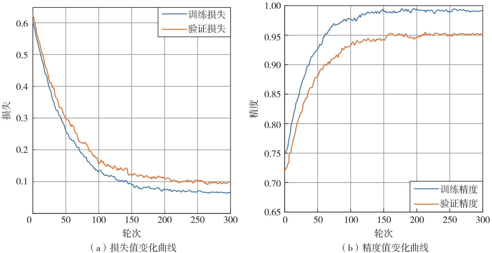
Fig. 8
Loss and accuracy curves of the graph Transformer during training"
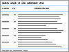
Tab. 1
Average results of different methods based on five-fold cross-validation"
| 方法 | 准确率/(%) | 召回率/(%) | F1值/(%) | 训练时间/min |
|---|---|---|---|---|
| GCN | 85.52 | 84.24 | 84.61 | 4.32 |
| GraphSAGE | 89.57 | 88.21 | 89.36 | 5.18 |
| Transformer | 92.25 | 91.82 | 92.03 | 7.64 |
| 本文方法 | 95.36 | 95.08 | 95.24 | 8.52 |
Tab. 2
Pattern prediction probabilities of four methods for different types of river networks"
| 编号 | 类别 | 方法 | 模式概率 | 预测类别 | ||||
|---|---|---|---|---|---|---|---|---|
| 树状 | 扇状 | 平行状 | 骨架状 | 格网状 | ||||
| (a) | 扇状 | GCN | 0.142 | 0.386 | 0.421 | 0.039 | 0.012 | 平行状 |
| GraphSAGE | 0.118 | 0.514 | 0.319 | 0.036 | 0.013 | 扇状 | ||
| Transformer | 0.071 | 0.761 | 0.126 | 0.030 | 0.012 | 扇状 | ||
| 本文方法 | 0.048 | 0.806 | 0.116 | 0.019 | 0.011 | 扇状 | ||
| (b) | 骨架状 | GCN | 0.248 | 0.054 | 0.038 | 0.577 | 0.083 | 骨架状 |
| GraphSAGE | 0.621 | 0.046 | 0.034 | 0.209 | 0.090 | 树状 | ||
| Transformer | 0.184 | 0.037 | 0.026 | 0.701 | 0.052 | 骨架状 | ||
| 本文方法 | 0.096 | 0.026 | 0.018 | 0.833 | 0.027 | 骨架状 | ||
| (c) | 树状 | GCN | 0.316 | 0.109 | 0.026 | 0.538 | 0.011 | 骨架状 |
| GraphSAGE | 0.672 | 0.092 | 0.023 | 0.201 | 0.012 | 树状 | ||
| Transformer | 0.748 | 0.061 | 0.017 | 0.164 | 0.010 | 树状 | ||
| 本文方法 | 0.879 | 0.038 | 0.011 | 0.062 | 0.010 | 树状 | ||
| (d) | 平行状 | GCN | 0.071 | 0.392 | 0.384 | 0.083 | 0.070 | 扇状 |
| GraphSAGE | 0.053 | 0.315 | 0.507 | 0.060 | 0.065 | 平行状 | ||
| Transformer | 0.031 | 0.216 | 0.719 | 0.018 | 0.016 | 平行状 | ||
| 本文方法 | 0.018 | 0.126 | 0.835 | 0.010 | 0.011 | 平行状 | ||
| (e) | 格网状 | GCN | 0.028 | 0.034 | 0.122 | 0.052 | 0.764 | 格网状 |
| GraphSAGE | 0.020 | 0.025 | 0.091 | 0.040 | 0.824 | 格网状 | ||
| Transformer | 0.012 | 0.014 | 0.053 | 0.025 | 0.896 | 格网状 | ||
| 本文方法 | 0.008 | 0.010 | 0.031 | 0.014 | 0.937 | 格网状 | ||
Tab. 3
Ablation experiment results of the proposed method"
| 试验设置 | GraphSAGE局部学习模块 | Transformer全局学习模块 | 三维地形特征 | 准确率/(%) | F1值/(%) |
|---|---|---|---|---|---|
| 去除Transformer全局学习模块 | √ | × | √ | 89.57 | 89.36 |
| 去除GraphSAGE局部学习模块 | × | √ | √ | 92.25 | 92.03 |
| 去除三维地形特征 | √ | √ | × | 93.13 | 92.86 |
| 本文方法 | √ | √ | √ | 95.36 | 95.24 |
Tab. 4
Contribution and combined effect analysis of three-dimensional terrain features"
| 特征组合 | 准确率 | 召回率 | F1值 |
|---|---|---|---|
| 无地形特征 | 93.13 | 92.75 | 92.86 |
| 高程差 | 93.78 | 93.52 | 93.71 |
| 坡度 | 93.85 | 93.65 | 93.73 |
| 比降 | 94.08 | 93.95 | 93.84 |
| 高程差-坡度 | 94.47 | 94.28 | 94.03 |
| 高程差-比降 | 94.16 | 93.98 | 93.72 |
| 坡度-比降 | 94.92 | 94.76 | 94.48 |
| 高程差-坡度-比降 | 95.36 | 95.08 | 95.24 |
Tab. 5
Cross-regional generalization experiment results"
| 区域 | 准确率 | 召回率 | F1值 |
|---|---|---|---|
| 原始数据集 | 95.36 | 95.08 | 95.24 |
| 长江流域 | 95.19 | 94.75 | 94.88 |
| 澜沧江流域 | 95.27 | 94.84 | 95.20 |
| [1] | 艾廷华, 刘耀林, 黄亚锋. 河网汇水区域的层次化剖分与地图综合[J]. 测绘学报, 2007, 36(2): 231-236, 243. |
| Ai Tinghua, Liu Yaolin, Huang Yafeng. The hierarchical watershed partitioning and generalization of river network[J]. Acta Geodaetica et Cartographica Sinica, 2007, 36(2): 231-236, 243. | |
| [2] |
刘呈熠, 武芳, 巩现勇, 等. 规则池塘群的复杂直线模式识别[J]. 测绘学报, 2020, 49(2): 256-266. DOI: .
doi: 10.11947/j.AGCS.2020.20190030 |
|
Liu Chengyi, Wu Fang, Gong Xianyong, et al. Complex linear pattern recognition for regular pond groups[J]. Acta Geodaetica et Cartographica Sinica, 2020, 49(2): 256-266. DOI: .
doi: 10.11947/j.AGCS.2020.20190030 |
|
| [3] | 王文宁. 多形态河系的流域基本单元特征分析、识别及相似度计算[D]. 兰州: 兰州交通大学, 2023. |
| Wang Wenning. Feature analysis, recognition and similarity calculation of watershed basic units in multi-morphology river systems[D]. Lanzhou: Lanzhou Jiaotong University, 2023. | |
| [4] | Yu Huafei, Ai Tinghua, Yang Min, et al. A recognition method for drainage patterns using a graph convolutional network[J]. International Journal of Applied Earth Observation and Geoinformation, 2022, 107: 102696. |
| [5] | Strahler A N. Quantitative analysis of watershed geomorphology[J]. Eos, Transactions American Geophysical Union, 1957, 38(6): 913-920. |
| [6] | 张园玉, 李霖, 金玉平, 等. 基于图论的树状河系结构化绘制模型研究[J]. 武汉大学学报(信息科学版), 2004, 29(6): 537-539, 543. |
| Zhang Yuanyu, Li Lin, Jin Yuping, et al. Structured design of dendritic river networks based on graph[J]. Geomatics and Information Science of Wuhan University, 2004, 29(6): 537-539, 543. | |
| [7] | 杜清运, 杨品福, 谭仁春. 基于空间统计特征的河网结构分类[J]. 武汉大学学报(信息科学版), 2006, 31(5): 419-422. |
| Du Qingyun, Yang Pinfu, Tan Renchun. Classification of river networks structure based on spatial statistical character[J]. Geomatics and Information Science of Wuhan University, 2006, 31(5): 419-422. | |
| [8] | Liu Chengyi, Zhai Renjian, Qian Haizhong, et al. Identification of drainage patterns using a graph convolutional neural network[J]. Transactions in GIS, 2023, 27(3): 752-776. |
| [9] | Wang Wenning, Yan Haowen, Lu Xiaomin, et al. Drainage pattern recognition method considering local basin shape based on graph neural network[J]. International Journal of Digital Earth, 2023, 16(1): 593-619. |
| [10] | Yu Huafei, Ai Tinghua, Yang Min, et al. A graph autoencoder network to measure the geometric similarity of drainage networks in scaling transformation[J]. International Journal of Digital Earth, 2023, 16(1): 1828-1852. |
| [11] | 翟仁健, 武芳, 邓红艳, 等. 基于遗传多目标优化的人工河网自动选取模型[J]. 测绘学报, 2008, 37(1): 108-113. |
| Zhai Renjian, Wu Fang, Deng Hongyan, et al. An automated selection model of ditch based on multi-objective optimization by genetic algorithm[J]. Acta Geodaetica et Cartographica Sinica, 2008, 37(1): 108-113. | |
| [12] | 邵黎霞, 何宗宜, 艾自兴, 等. 基于BP神经网络的河系自动综合研究[J]. 武汉大学学报(信息科学版), 2004, 29(6): 555-557. |
| Shao Lixia, He Zongyi, Ai Zixing, et al. Automatic generalization of river network based on BP neural network techniques[J]. Geomatics and Information Science of Wuhan University, 2004, 29(6): 555-557. | |
| [13] |
黄哲琨, 钱海忠, 蔡中祥, 等. 基于图神经网络的多尺度网状河系分类匹配方法[J]. 测绘学报, 2025, 54(2): 371-384. DOI: .
doi: 10.11947/j.AGCS.2025.20240145 |
|
Huang Zhekun, Qian Haizhong, Cai Zhongxiang, et al. A multi-scale mesh river system classification matching method based on graph neural network[J]. Acta Geodaetica et Cartographica Sinica, 2025, 54(2): 371-384. DOI: .
doi: 10.11947/j.AGCS.2025.20240145 |
|
| [14] | Zhou Jie, Cui Ganqu, Hu Shengding, et al. Graph neural networks: a review of methods and applications[J]. AI Open, 2020, 1: 57-81. |
| [15] | 王米琪. 基于图卷积神经网络的道路网模式识别[D]. 武汉: 武汉大学, 2021. |
| Wang Miqi. Road network pattern recognition based on graph convolutional neural network[D]. Wuhan: Wuhan University, 2021. | |
| [16] |
刘慧敏, 胡文柯, 唐建波, 等. 顾及功能语义特征的建筑物空间分布模式识别方法[J]. 测绘学报, 2020, 49(5): 622-631. DOI: .
doi: 10.11947/j.AGCS.2020.20190222 |
|
Liu Huimin, Hu Wenke, Tang Jianbo, et al. A method for recognizing building clusters by considering functional features of buildings[J]. Acta Geodaetica et Cartographica Sinica, 2020, 49(5): 622-631. DOI: .
doi: 10.11947/j.AGCS.2020.20190222 |
|
| [17] | Yan Xiongfeng, Ai Tinghua, Yang Min, et al. A graph convolutional neural network for classification of building patterns using spatial vector data[J]. ISPRS Journal of Photogrammetry and Remote Sensing, 2019, 150: 259-273. |
| [18] | Xu Xiaofeng, Liu Pengcheng, Guo Mingwu. Drainage pattern recognition of river network based on graph convolutional neural network[J]. ISPRS International Journal of Geo-Information, 2023, 12(7): 253. |
| [19] | Yu Huafei, Ai Tinghua, Yang Min, et al. Integrating domain knowledge and graph convolutional neural networks to support river network selection[J]. Transactions in GIS, 2023, 27(7): 1898-1927. |
| [20] | Yu Huafei, Ai Tinghua, Yang Min, et al. Automatic segmentation of parallel drainage patterns supported by a graph convolution neural network[J]. Expert Systems with Applications, 2023, 211: 118639. |
| [21] | Qiang Bo, Liu Tao, Du Ping, et al. Drainage pattern recognition method using graph convolutional networks combined with three-dimensional elevation features[J]. Transactions in GIS, 2025, 29: e70002. |
| [22] |
王亚青, 王中辉. 异构图卷积网络支持下的河系自动选取方法[J]. 测绘学报, 2025, 54(7): 1332-1345. DOI: .
doi: 10.11947/j.AGCS.2025.20240337 |
|
Wang Yaqing, Wang Zhonghui. River network automated selection method based on heterogeneous graph convolutional networks[J]. Acta Geodaetica et Cartographica Sinica, 2025, 54(7): 1332-1345. DOI: .
doi: 10.11947/j.AGCS.2025.20240337 |
|
| [23] |
余华飞, 邱天奇, 周哲, 等. 图Transformer支持下的河网模式识别[J]. 测绘学报, 2024, 53(11): 2075-2085. DOI: .
doi: 10.11947/j.AGCS.2024.20230582 |
|
Yu Huafei, Qiu Tianqi, Zhou Zhe, et al. Drainage pattern recognition supported by graph Transformer[J]. Acta Geodaetica et Cartographica Sinica, 2024, 53(11): 2075-2085. DOI: .
doi: 10.11947/j.AGCS.2024.20230582 |
|
| [24] | Vaswani A, Shazeer N, Parmar N, et al. Attention is all you need[C]//Proceedings of 2017 Advances in Neural Information Processing Systems. Long Beach: Curran Associates, 2017: 5998-6008. |
| [1] | Yang LI, Haijun HUANG, Sulan LIU, Xiaohui WU, Qi LIU, Qipei PANG, Yunlong WU. Century-scale projection of terrestrial water storage anomaly and drought risk in the Poyang Lake Basin using a CMIP6-driven Transformer-GRU model [J]. Acta Geodaetica et Cartographica Sinica, 2026, 55(4): 721-738. |
| [2] | Pengcheng LIU, Xiaoqiang CHENG, Tianyuan XIAO, Min YANG, Tinghua AI. A Transformer model for building polygon simplification in map generalization [J]. Acta Geodaetica et Cartographica Sinica, 2026, 55(1): 124-137. |
| [3] | Qing CHENG, Boxuan WANG, Hongyan ZHANG. DRformer: a progressive coupled multiscale CNN and condensed attention Transformer method for hyperspectral image super-resolution [J]. Acta Geodaetica et Cartographica Sinica, 2025, 54(7): 1230-1242. |
| [4] | Chao WANG, Tianyu CHEN, Tong ZHANG, Tanvir AHMED, Liqiang JI, Tao XIE, Jiajun YANG, Shuai WANG. Multi-sensor optical remote sensing images change detection based on global differential enhancement module and balance penalty loss [J]. Acta Geodaetica et Cartographica Sinica, 2025, 54(5): 873-887. |
| [5] | Zhiwei XIE, Shuaizhi ZHAI, Fengyuan ZHANG, Min CHEN, Lishuang SUN. Object-oriented high-resolution image classification using inductive graph neural networks [J]. Acta Geodaetica et Cartographica Sinica, 2024, 53(8): 1610-1623. |
| [6] | Quanyi ZHAO, Fujian ZHENG, Bo XIA, Zhengying LI, Hong HUANG. Hyperspectral remote sensing image scene classification method based on deep manifold distillation network [J]. Acta Geodaetica et Cartographica Sinica, 2024, 53(12): 2404-2415. |
| [7] | Shiyan PANG, Jingjing HAO, Zhiqi ZUO, Jingjing LAN, Xiangyun HU. A high-resolution remote sensing images change detection method via the integration of dense connections and self-attention mechanisms [J]. Acta Geodaetica et Cartographica Sinica, 2024, 53(12): 2244-2253. |
| [8] | Huafei YU, Tianqi QIU, Zhe ZHOU, Chongya GONG, Tianyuan XIAO, Min YANG, Tinghua AI. Drainage pattern recognition supported by graph Transformer [J]. Acta Geodaetica et Cartographica Sinica, 2024, 53(11): 2075-2085. |
| [9] | ZHANG Yichao, ZHENG Xiangtao, LU Xiaoqiang. Hyperspectral image classification method based on hierarchical transformer network [J]. Acta Geodaetica et Cartographica Sinica, 2023, 52(7): 1139-1147. |
| [10] | WU Chenhao, XIANG Longgang, ZHANG Yeting, WU Huayi. Geography-aware representation learning for trajectory similarity computation [J]. Acta Geodaetica et Cartographica Sinica, 2023, 52(4): 670-678. |
| [11] | WANG Wei, DENG Jiwei, WANG Xin, LI Zhiyong, YUAN Ping. GLFFNet model for remote sensing image scene classification [J]. Acta Geodaetica et Cartographica Sinica, 2023, 52(10): 1693-1702. |
| [12] | JI Hongchao, DONG Jian, LI Shujun, ZHANG Zhiqiang, WEI Yuan. Non-navigational TIN-DDM automatic generalization algorithm considering topographic forms and terrain features [J]. Acta Geodaetica et Cartographica Sinica, 2023, 52(1): 129-141. |
| Viewed | ||||||
|
Full text |
|
|||||
|
Abstract |
|
|||||
