

Acta Geodaetica et Cartographica Sinica ›› 2024, Vol. 53 ›› Issue (7): 1371-1383.doi: 10.11947/j.AGCS.2024.20230074
• Photogrammetry and Remote Sensing • Previous Articles Next Articles
Wei WANG( ), Wei ZHENG, Xin WANG()
Received:2023-03-16
Published:2024-08-12
Contact:
Xin WANG
E-mail:wangwei@csust.edu.cn;wangxin@csust.edu.cn
About author:WANG Wei (1974—), male, PhD, professor, PhD supervisor, majors in computer vision and pattern recognition. E-mail: wangwei@csust.edu.cn
Supported by:CLC Number:
Wei WANG, Wei ZHENG, Xin WANG. LAG-MANet model for remote sensing image scene classification[J]. Acta Geodaetica et Cartographica Sinica, 2024, 53(7): 1371-1383.
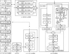
Fig.1
LAG-MANet structure"


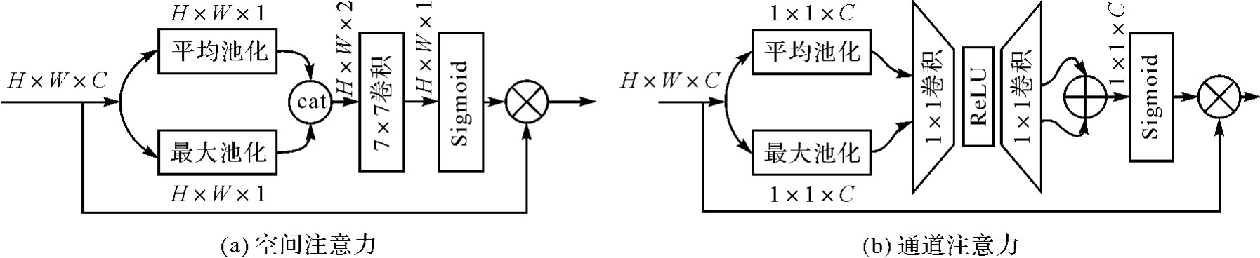
Fig.2
Spatial attention and channel attention structure"
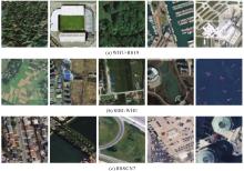
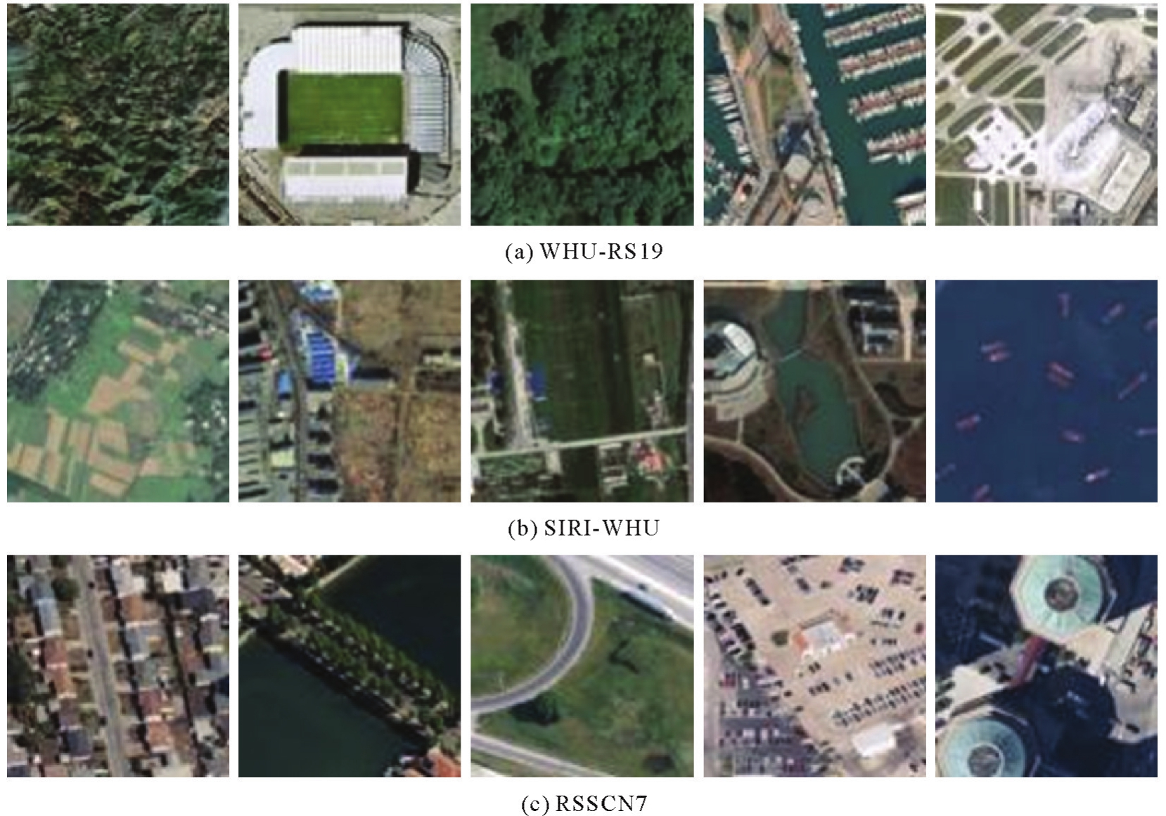
Some samples of datasets"
Experimental results of different numbers of dilated convolution branches in MBDConv module"
| 模型 | 扩张率 | 准确率/(%) |
|---|---|---|
| LAG-MANet-1 | × | 94.43±0.31 |
| LAG-MANet-2 | [2] | 96.04±0.57 |
| LAG-MANet-3 | [1,2] | 96.57±0.35 |
| LAG-MANet-4 | [1,2,3] | 96.32±0.22 |
| LAG-MANet | [1,2,3,4] | 97.18±0.41 |
| LAG-MANet-5 | [1,2,3,4,5] | 96.18±0.24 |
Experimental results of different spatial interaction dimensions in MSI module"
| 模型 | 各阶段空间交互维度(n) | 准确率/(%) | |||
|---|---|---|---|---|---|
| 一 | 二 | 三 | 四 | ||
| LAG-MANet-6 | 2 | 3 | 3 | 3 | 95.89±0.41 |
| LAG-MANet-7 | 2 | 3 | 4 | 4 | 96.25±0.30 |
| LAG-MANet-8 | 2 | 3 | 4 | 5 | 96.21±0.24 |
| LAG-MANet-9 | 3 | 3 | 4 | 4 | 96.43±0.67 |
| LAG-MANet-10 | 3 | 3 | 4 | 5 | 96.47±0.58 |
| LAG-MANet | 3 | 3 | 3 | 3 | 97.18±0.41 |
Experimental results of dismantling the P2DF module"
| 模型 | RAC | SAM | MSI | CAM | RPFF | 准确率/(%) |
|---|---|---|---|---|---|---|
| LAG-MANet-11 | × | √ | √ | √ | √ | 95.03±0.38 |
| LAG-MANet-12 | √ | × | √ | √ | √ | 96.61±0.39 |
| LAG-MANet-13 | √ | √ | × | √ | √ | 95.96±0.57 |
| LAG-MANet-14 | √ | √ | √ | × | √ | 96.18±0.29 |
| LAG-MANet-15 | √ | √ | √ | √ | × | 92.43±0.53 |
| LAG-MANet-16 | × | × | √ | √ | √ | 93.86±0.55 |
| LAG-MANet-17 | √ | √ | × | × | √ | 95.93±0.31 |
| LAG-MANet-18 | √ | × | √ | × | √ | 96.32±0.18 |
| LAG-MANet-19 | × | √ | × | √ | √ | 95.43±0.18 |
| LAG-MANet-20 | × | √ | √ | × | √ | 94.79±0.48 |
| LAG-MANet-21 | √ | × | × | √ | √ | 96.14±0.40 |
| LAG-MANet | √ | √ | √ | √ | √ | 97.18±0.41 |
Experimental results of the models on WHU-RS19 dataset"
| 模型 | 准确率 | 精确率 | 召回率 | 特异性 | F1值 |
|---|---|---|---|---|---|
| ResNet50[ | 97.45±0.32 | 97.71±0.37 | 97.42±0.34 | 99.87±0.02 | 97.43±0.35 |
| VGG16[ | 92.25±1.59 | 93.05±1.48 | 92.31±1.59 | 99.57±0.08 | 92.27±1.60 |
| EfficientNetV2[ | 97.04±0.20 | 97.21±0.18 | 97.06±0.21 | 99.85±0.01 | 97.03±0.20 |
| ConvNext[ | 90.82±1.07 | 91.70±1.00 | 90.92±0.95 | 99.50±0.06 | 90.79±1.03 |
| ViT[ | 81.73±1.04 | 83.46±1.57 | 81.82±1.00 | 98.99±0.06 | 81.65±1.06 |
| SwinTransformer[ | 92.96±1.09 | 93.63±0.99 | 93.08±1.07 | 99.62±0.06 | 93.02±1.09 |
| PoolFormer[ | 93.17±0.89 | 93.73±0.81 | 93.20±0.86 | 99.63±0.05 | 93.18±0.85 |
| Hornet[ | 88.88±0.59 | 89.84±1.10 | 89.03±0.59 | 99.39±0.04 | 88.85±0.80 |
| MogaNet[ | 96.74±0.25 | 97.03±0.27 | 96.70±0.26 | 99.83±0.01 | 96.71±0.25 |
| VAN[ | 96.53±0.82 | 96.79±0.76 | 96.53±0.84 | 99.82±0.05 | 96.50±0.83 |
| EMTCAL[ | 88.06±0.79 | 88.93±0.76 | 87.97±0.83 | 99.35±0.04 | 87.89±0.83 |
| GCSANet[ | 96.10±0.41 | 96.34±0.41 | 96.07±0.39 | 99.79±0.02 | 96.04±0.42 |
| LAG-MANet-Split | 97.86±0.50 | 98.04±0.45 | 97.87±0.51 | 99.89±0.03 | 97.86±0.50 |
| LAG-MANet | 97.76±0.25 | 97.93±0.20 | 97.72±0.27 | 99.88±0.01 | 97.72±0.27 |
Comparison of complexity of different models"
| 模型 | 参数量(×106) | 计算量(×106) |
|---|---|---|
| ResNet50[ | 23.52 | 4 131.71 |
| VGG16[ | 134.29 | 15 466.20 |
| EfficientNetV2[ | 20.19 | 2 897.32 |
| ConvNext[ | 27.80 | 4 454.77 |
| ViT[ | 85.65 | 16 862.87 |
| SwinTransformer[ | 27.50 | 4 371.13 |
| PoolFormer[ | 20.84 | 3 393.76 |
| Hornet[ | 21.86 | 3 967.88 |
| MogaNet[ | 24.79 | 4 947.57 |
| VAN[ | 13.35 | 2 505.09 |
| EMTCAL[ | 27.8 | 4 233.93 |
| GCSANet[ | 14.16 | 5 677.51 |
| LAG-MANet-Split | 5.01 | 1 603.94 |
| LAG-MANet | 12.51 | 3 648.77 |
Experimental results of the models on SIRI-WHU dataset"
| 模型 | 准确率 | 精确率 | 召回率 | 特异性 | F1值 |
|---|---|---|---|---|---|
| ResNet50[ | 96.38±0.28 | 96.48±0.27 | 96.38±0.28 | 99.67±0.02 | 96.38±0.28 |
| VGG16[ | 93.67±0.98 | 93.82±0.99 | 93.67±0.98 | 99.42±0.09 | 93.66±0.99 |
| EfficientNetV2[ | 96.21±0.31 | 96.28±0.29 | 96.21±0.31 | 99.65±0.03 | 96.21±0.31 |
| ConvNext[ | 93.54±0.68 | 93.82±0.59 | 93.54±0.68 | 99.42±0.06 | 93.53±0.70 |
| ViT[ | 91.58±0.52 | 91.92±0.67 | 91.58±0.52 | 99.23±0.05 | 91.46±0.51 |
| SwinTransformer[ | 95.63±0.23 | 95.73±0.23 | 95.62±0.23 | 99.59±0.02 | 95.60±0.23 |
| PoolFormer[ | 95.50±0.31 | 95.65±0.33 | 95.50±0.31 | 99.58±0.03 | 95.50±0.32 |
| Hornet[ | 92.96±0.87 | 93.19±0.90 | 92.96±0.87 | 99.37±0.08 | 92.97±0.87 |
| MogaNet[ | 95.83±0.46 | 95.92±0.48 | 95.83±0.46 | 99.62±0.05 | 95.84±0.46 |
| VAN[ | 95.54±0.39 | 95.66±0.34 | 95.54±0.39 | 99.59±0.03 | 95.53±0.40 |
| EMTCAL[ | 93.50±0.30 | 93.66±0.30 | 93.50±0.30 | 99.41±0.03 | 93.51±0.30 |
| GCSANet[ | 93.90±0.84 | 94.01±0.77 | 93.91±0.84 | 99.45±0.08 | 93.9±0.84 |
| LAG-MANet-Split | 96.50±0.24 | 96.61±0.21 | 96.50±0.24 | 99.68±0.02 | 96.49±0.24 |
| LAG-MANet | 97.04±0.20 | 97.13±0.18 | 97.04±0.20 | 99.73±0.01 | 97.04±0.20 |
Tab.7
Experimental results of the models on RSSCN7 dataset"
| 模型 | 准确率 | 精确率 | 召回率 | 特异性 | F1值 |
|---|---|---|---|---|---|
| ResNet50[ | 95.93±0.41 | 95.95±0.42 | 95.94±0.41 | 99.34±0.07 | 95.93±0.42 |
| VGG16[ | 91.43±0.80 | 91.44±0.85 | 91.43±0.80 | 95.58±0.14 | 91.38±0.83 |
| EfficientNetV2[ | 95.14±0.21 | 95.16±0.20 | 95.15±0.22 | 99.22±0.03 | 95.13±0.21 |
| ConvNext[ | 90.86±1.04 | 90.93±1.03 | 90.86±1.04 | 98.49±0.18 | 90.82±1.04 |
| ViT[ | 90.61±0.27 | 90.62±0.23 | 90.61±0.26 | 98.43±0.05 | 90.57±0.27 |
| SwinTransformer[ | 94.75±0.62 | 94.83±0.58 | 94.75±0.61 | 99.15±0.11 | 94.73±0.62 |
| PoolFormer[ | 94.43±0.52 | 94.48±0.52 | 94.43±0.52 | 99.10±0.09 | 94.41±0.53 |
| Hornet[ | 89.43±0.84 | 89.47±0.83 | 89.43±0.85 | 98.23±0.14 | 89.34±0.87 |
| MogaNet[ | 95.14±0.37 | 95.17±0.36 | 95.14±0.38 | 99.21±0.06 | 95.13±0.37 |
| VAN[ | 94.22±0.33 | 94.27±0.36 | 94.22±0.33 | 99.06±0.06 | 94.19±0.33 |
| EMTCAL[ | 93.57±0.25 | 93.76±0.28 | 93.56±0.25 | 98.94±0.04 | 93.61±0.26 |
| GCSANet[ | 92.84±0.41 | 92.99±0.41 | 92.85±0.41 | 98.82±0.07 | 92.83±0.41 |
| LAG-MANet-Split | 96.07±0.16 | 96.12±0.21 | 96.07±0.17 | 99.37±0.02 | 96.07±0.17 |
| LAG-MANet | 97.18±0.41 | 97.20±0.43 | 97.18±0.42 | 99.55±0.07 | 97.18±0.42 |

Fig.4
Confusion matrix on WHU-RS19 dataset"

Fig.5
Confusion matrix on SIRI-WHU dataset"
Fig.6
Confusion matrix on RSSCN7 dataset"
Fig.7
Visual heat maps on WHU-RS19 dataset"
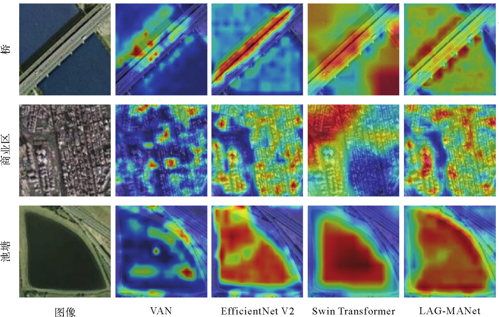

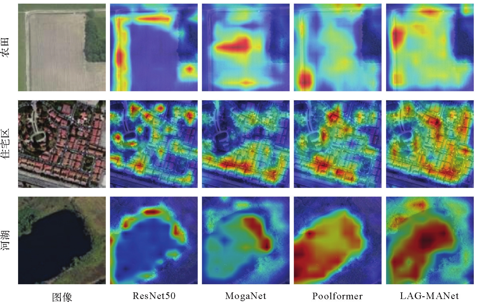
Fig.8
Visual heat maps on RSSCN7 dataset"
| [1] | 龚健雅, 张觅, 胡翔云, 等. 智能遥感深度学习框架与模型设计[J]. 测绘学报, 2022, 51(4):475-487. DOI: 10.11947/j.AGCS.2022.20220027. |
| GONG Jianya, ZHANG Mi, HU Xiangyun, et al. The design of deep learning framework and model for intelligent remote sensing[J]. Acta Geodaetica et Cartographica Sinica, 2022, 51(4):475-487. DOI: 10.11947/j.AGCS.2022.20220027. | |
| [2] | 吴琼, 葛大庆, 于峻川, 等. 广域滑坡灾害隐患InSAR显著性形变区深度学习识别技术[J]. 测绘学报, 2022, 51(10):2046-2055. DOI: 10.11947/j.AGCS.2022.20220303. |
| WU Qiong, GE Daqing, YU Junchuan, et al. Deep learning identification technology of InSAR significant deformation zone of potential landslide hazard at large scale[J]. Acta Geodaetica et Cartographica Sinica, 2022, 51(10):2046-2055. DOI: 10.11947/j.AGCS.2022.20220303. | |
| [3] | CHENG Gong, XIE Xingxing, HAN Junwei, et al. Remote sensing image scene classification meets deep learning: challenges, methods, benchmarks, and opportunities[J]. IEEE Journal of Selected Topics in Applied Earth Observations and Remote Sensing, 2020, 13:3735-3756. |
| [4] | CHEN Leiyu, LI Shaobo, BAI Qiang, et al. Review of image classification algorithms based on convolutional neural networks[J]. Remote Sensing, 2021, 13(22):4712. |
| [5] | YUAN Yuan, FANG Jie, LU Xiaoqiang, et al. Remote sensing image scene classification using rearranged local features[J]. IEEE Transactions on Geoscience and Remote Sensing, 2019, 57(3):1779-1792. |
| [6] | AKODAD S, BOMBRUN L, XIA Junshi, et al. Ensemble learning approaches based on covariance pooling of CNN features for high resolution remote sensing scene classification[J]. Remote Sensing, 2020, 12(20):3292. |
| [7] | TONG Wei, CHEN Weitao, HAN Wei, et al. Channel-attention-based DenseNet network for remote sensing image scene classification[J]. IEEE Journal of Selected Topics in Applied Earth Observations and Remote Sensing, 2020, 13:4121-4132. |
| [8] | HU Jie, SHEN Li, SUN Gang. Squeeze-and-excitation networks[C]//Proceedings of 2018 IEEE conference on computer vision and pattern recognition. Salt Lake City: IEEE, 2018: 7132-7141. |
| [9] | ZHANG Guokai, XU Weizhe, ZHAO Wei, et al. A multiscale attention network for remote sensing scene images classification[J]. IEEE Journal of Selected Topics in Applied Earth Observations and Remote Sensing, 2021, 14:9530-9545. |
| [10] | VASWANI A, SHAZEER N, PARMAR N, et al. Attention is all you need[J]. Advances in neural Information processing systems, 2017, 30:6000-6010. |
| [11] | DOSOVITSKIY A, BEYER L, KOLESNIKOV A, et al. An image is worth 16x16 words: transformers for image recognition at scale[C]//Proceedings of the 9th International Conference on Learning Representations. Virtual Event: IEEE, 2020: 1-12. |
| [12] | BAZI Y, BASHMAL L, AL RAHHAL M M, et al. Vision transformers for remote sensing image classification[J]. Remote Sensing, 2021, 13(3):516. |
| [13] | 王威, 邓纪伟, 王新, 等. 面向遥感图像场景分类的GLFFNet模型[J]. 测绘学报, 2023, 52(10):1693-1702. DOI: 10.11947/j.AGCS.2023.20220286. |
| WANG Wei, DENG Jiwei, WANG Xin, et al. GLFFNet model for remote sensing image scene classification[J]. Acta Geodaetica et Cartographica Sinica, 2023, 52(10):1693-1702. DOI: 10.11947/j.AGCS.2023.20220286. | |
| [14] | WANG Wei, HU Ting, WANG Xin, et al. BFRNet: bidimensional feature representation network for remote sensing images classification[J]. IEEE Transactions on Geoscience and Remote Sensing, 2023, 61:3313800. |
| [15] | DENG Peifang, XU Kejie, HUANG Hong. When CNNs meet vision transformer: a joint framework for remote sensing scene classification[J]. IEEE Geoscience and Remote Sensing Letters, 2022, 19:3109061. |
| [16] | RAO Yongming, ZHAO Wenliang, TANG Yansong, et al. Hornet: efficient high-order spatial interactions with recursive gated convolutions[C]//Proceedings of2022 Advances in Neural Information Processing Systems. [S.l.]: IEEE, 2022. |
| [17] | DING Xiaohan, ZHANG Xiangyu, HAN Jungong, et al. Scaling up your kernels to 31x31: revisiting large kernel design in cnns[C]//Proceedings of 2022 IEEE/CVF Conference on Computer Vision and Pattern Recognition. New Orleans: IEEE, 2022: 11963-11975. |
| [18] | GUO Menghao, LU Chengze, LIU Zhengning, et al. Visual attention network[J]. Computational Visual Media, 2023, 9(4):733-752. |
| [19] | WOO S, PARK J, Lee J Y, et al. CBAM: convolutional block attention module[C]//Proceedings of 2018 European conference on computer vision. Cham: Springer, 2018: 3-19. |
| [20] | LIU Zhuang, MAO Hanzi, WU Chaoyuan, et al. A ConvNet for the 2020s[C]//Proceedings of 2022 IEEE/CVF Conference on Computer Vision and Pattern Recognition. New Orleans: IEEE, 2022: 11966-11976. |
| [21] | XIA G S, YANG Wen, DELON J, et al. Structural high-resolution satellite image indexing[C]//Proceedings of 2010 ISPRS TC VII Symposium. [S.l.]: ISPRS, 2010: 298-303. |
| [22] | ZHU Qiqi, ZHONG Yanfei, ZHAO Bei, et al. Bag-of-visual-words scene classifier with local and global features for high spatial resolution remote sensing imagery[J]. IEEE Geoscience and Remote Sensing Letters, 2016, 13(6):747-751. |
| [23] | ZOU Qin, NI Lihao, ZHANG Tong, et al. Deep learning based feature selection for remote sensing scene classification[J]. IEEE Geoscience and Remote Sensing Letters, 2015, 12(11):2321-2325. |
| [24] | IOFFE S, SZEGEDY C. Batch normalization: accelerating deep network training by reducing internal covariate shift[C]//Proceedings of the 32nd International Conference on International Conference on Machine Learning. Lille: ACM Press, 2015: 448-456. |
| [25] | KINGMA D P, BA J. Adam: a method for stochastic optimization[C]//Proceedings of the 3rd International Conference for Learning Representations. [S.l.]: IEEE, 2015: 1-13. |
| [26] | SIMONYAN K, ZISSERMAN A. Very deep convolutional networks for large-scale image recognition[C]//Proceedings of the 3rd International Conference for Learning Representations. [S.l.]: IEEE, 2015: 463-476. |
| [27] | LIU Ze, LIN Yutong, CAO Yue, et al. SwinTransformer: hierarchical vision transformer using shifted windows[C]//Proceedings of the 2021 IEEE/CVF International Conference on Computer Vision. Montreal: IEEE, 2021: 10012-10022. |
| [28] | HE Kaiming, ZHANG Xiangyu, REN Shaoqing, et al. Deep residual learning for image recognition[C]//Proceedings of 2016 IEEE Conference on Computer Vision and Pattern Recognition. Las Vegas: IEEE, 2016: 770-778. |
| [29] | TAN M, LE Q. EfficientNetV2: smaller models and faster training[C]//Proceedings of 2021 International Conference on Machine Learning. BALTIMORE: IEEE, 2021: 10096-10106. |
| [30] | YU Weihao, LUO Mi, ZHOU Pan, et al. MetaFormer is actually what you need for vision[C]//Proceedings of 2022 IEEE/CVF conference on computer vision and pattern recognition. New Orleans: IEEE, 2022: 10819-10829. |
| [31] | LI Siyuan, WANG Zedong, LIU Zicheng, et al. Efficient multi-order gated aggregation network[EB/OL]. [2022-11-07]. https://arxiv.org/abs/2211.03295. |
| [32] | TANG Xu, LI Mingteng, MA Jingjing, et al. EMTCAL: efficient multiscale transformer and cross-level attention learning for remote sensing scene classification[J]. IEEE Transactions on Geoscience and Remote Sensing, 2022, 60:3194505. |
| [33] | CHEN Weitao, OUYANG Shubing, TONG Wei, et al. GCSANet: a global context spatial attention deep learning network for remote sensing scene classification[J]. IEEE Journal of Selected Topics in Applied Earth Observations and Remote Sensing, 2022, 15:1150-1162. |
| [34] | SELVARAJU R R, COGSWELL M, DAS A, et al. Grad-CAM: visual explanations from deep networks via gradient-based localization[J]. International Journal of Computer Vision, 2020, 128(2):336-359. |
| [1] | Shunping JI, Jin LIU, Jian GAO, Jianya GONG. An intelligent 3D reconstruction framework via deep learning based multi-view image matching [J]. Acta Geodaetica et Cartographica Sinica, 2025, 54(9): 1633-1646. |
| [2] | Yakun XIE, Yaoji ZHAO, Jiaxing TU, Ruifeng XIA, Dejun FENG, Suning LIU, Hongyu CHEN, Jun ZHU. Edge and global features integrated network for salient object detection in optical remote sensing images [J]. Acta Geodaetica et Cartographica Sinica, 2025, 54(7): 1265-1279. |
| [3] | Zibo DONG, Jingxue WANG, Lijing BU, Lin FANG, Zhenghui XU. MAFNet: building extraction method from remote sensing images based on multi-scale atrous fusion network [J]. Acta Geodaetica et Cartographica Sinica, 2025, 54(6): 1094-1106. |
| [4] | Haifeng LI, Wang GUO, Mengwei WU, Chengli PENG, Qing ZHU, Yu LIU, Chao TAO. Visual-language joint representation and intelligent interpretation of remote sensing geo-objects: principles, challenges and opportunities [J]. Acta Geodaetica et Cartographica Sinica, 2025, 54(5): 853-872. |
| [5] | Chao WANG, Tianyu CHEN, Tong ZHANG, Tanvir AHMED, Liqiang JI, Tao XIE, Jiajun YANG, Shuai WANG. Multi-sensor optical remote sensing images change detection based on global differential enhancement module and balance penalty loss [J]. Acta Geodaetica et Cartographica Sinica, 2025, 54(5): 873-887. |
| [6] | Yiming ZHAO, Kelin HU, Kelong TU, Yaxian QING, Chao YANG, Kunlun QI, Huayi WU. Multi-label scene classification method based on fusion of SAR and optical remote sensing images [J]. Acta Geodaetica et Cartographica Sinica, 2025, 54(5): 911-923. |
| [7] | Xinchang ZHANG, Ji QI, Chao TAO, Siyang FU, Mingning GUO, Yongjian RUAN. A survey on cloud removal in optical remote sensing images: progress, challenges, and future works [J]. Acta Geodaetica et Cartographica Sinica, 2025, 54(4): 603-620. |
| [8] | Zhaoyang HOU, Haowen YAN, Liming ZHANG, Rongjuan MA, Ruitao QU. Zero-watermark copyright protection method for remote sensing images based on coupled neural P system and blockchain [J]. Acta Geodaetica et Cartographica Sinica, 2025, 54(12): 2247-2261. |
| [9] | Xi GONG, Zhanlong CHEN, Hengqiang ZHENG, Sheng HU, Hongyan ZHANG. Remote sensing image scene classification method integrating spatial and semantic information of transferred features [J]. Acta Geodaetica et Cartographica Sinica, 2025, 54(11): 2009-2025. |
| [10] | Zhili ZHANG, Huiwei JIANG, Xiangyun HU. A minimal-interaction framework for accurate and batch extraction of geospatial objects from remote sensing imagery [J]. Acta Geodaetica et Cartographica Sinica, 2025, 54(10): 1863-1876. |
| [11] | Liangxiong GONG, Xinghua LI, Yuanming CHENG, Xingyou ZHAO, Renping XIE, Honggen WANG. A lightweight remote sensing images change detection network utilizing spatio-temporal difference enhancement and adaptive feature fusion [J]. Acta Geodaetica et Cartographica Sinica, 2025, 54(1): 136-153. |
| [12] | Jialing LI, Ji QI, Weipeng LU, Chao TAO. Self-supervised learning based urban functional zone classification by integrating optical remote sensing image-OSM data [J]. Acta Geodaetica et Cartographica Sinica, 2025, 54(1): 154-164. |
| [13] | Xin YAN, Li SHEN, Junjie PAN, Yanshuai DAI, Jicheng WANG, Xiaoli ZHENG, Zhi-lin LI. Weakly supervised building change detection integrating multi-scale feature fusion and spatial refinement for high resolution remote sensing images [J]. Acta Geodaetica et Cartographica Sinica, 2024, 53(8): 1586-1597. |
| [14] | Zhiwei XIE, Shuaizhi ZHAI, Fengyuan ZHANG, Min CHEN, Lishuang SUN. Object-oriented high-resolution image classification using inductive graph neural networks [J]. Acta Geodaetica et Cartographica Sinica, 2024, 53(8): 1610-1623. |
| [15] | Jichong YIN, Fang WU, Renjian ZHAI, Yue QIU, Xianyong GONG, Ruixing XING. Two-stream boundary constraints and relativistic generation adversarial network for building contour regularization [J]. Acta Geodaetica et Cartographica Sinica, 2024, 53(7): 1444-1457. |
| Viewed | ||||||
|
Full text |
|
|||||
|
Abstract |
|
|||||