

Acta Geodaetica et Cartographica Sinica ›› 2025, Vol. 54 ›› Issue (10): 1757-1768.doi: 10.11947/j.AGCS.2025.20250129
• Geodesy and Navigation • Previous Articles Next Articles
Chaolong YAO1,2,3( ), Hongrui YOU1, Xuanhui HE1, Junya LU1, Yiqian XIE1, Qiong LI2,4(), Shuang ZHU5, Zhicai LUO2,6
Received:2025-03-24
Revised:2025-10-18
Online:2025-11-14
Published:2025-11-14
Contact:
Qiong LI
E-mail:clyao@scau.edu.cn;qiongli@swpu.edu.cn
About author:YAO Chaolong (1986—), male, PhD, associate professor, majors in hydrological, meteorological and drought geodesy. E-mail: clyao@scau.edu.cn
Supported by:CLC Number:
Chaolong YAO, Hongrui YOU, Xuanhui HE, Junya LU, Yiqian XIE, Qiong LI, Shuang ZHU, Zhicai LUO. A composite drought index derived from a combination of GNSS PWV/vertical deformation and GRACE/GRACE-FO data[J]. Acta Geodaetica et Cartographica Sinica, 2025, 54(10): 1757-1768.

Fig. 1
Distribution of GNSS stations"

Tab. 1
Information about the adopted data in this study"
| 数据类型 | 时间分辨率 | 空间表达形式 | 数据来源 |
|---|---|---|---|
| GNSS PWV | 1小时 | 站点 | ftp://ftp.cgps.ac.cn/ |
| GNSS垂向形变 | 1天 | ||
| 大气、非潮汐海洋负荷垂向形变 | 3小时 | 0.5°×0.5° | |
| GRACE/GRACE-FO | 1个月 | 0.5°×0.5° | |
| 降水 | 1天 | 0.1°×0.1° | |
| GLDAS | 1个月 | 0.5°×0.5° | |
| SPEI | 1个月 | 0.5°×0.5° |
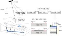
Fig. 2
Conceptual diagram of meteorological and hydrological composite drought monitoring by combing GNSS and satellite gravimetry data"
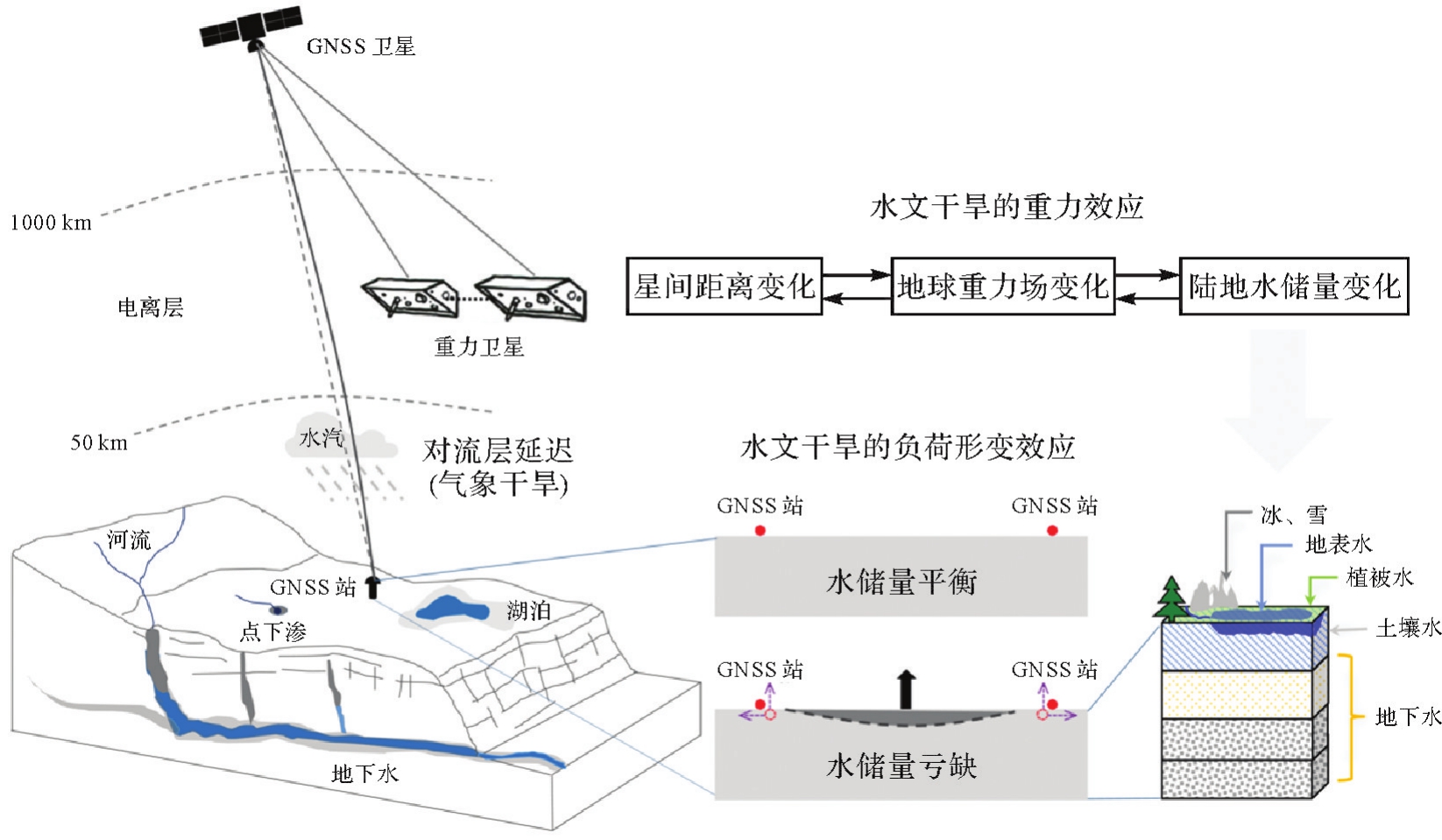

Fig. 3
The flowchart of the proposed method"


Fig. 4
Data fusion results of robust Helmert variance estimation and RPCA under different schemes"

Tab. 2
Statistical results of the deviation of the fusion results of two robust estimation methods relative to the average of signal 1 and signal 2"
| 方案 | 方法 | 最小值 | 最大值 | 平均值 | 绝对平均值 | 标准差 |
|---|---|---|---|---|---|---|
| 方案1 | 抗差Helmert方差估计 | -2.69 | 3.06 | 0.00 | 0.05 | 0.34 |
| RPCA | -1.87 | 2.89 | -0.07 | 0.51 | 0.65 | |
| 方案2 | 抗差Helmert方差估计 | -2.69 | 4.22 | 0.08 | 0.13 | 0.60 |
| RPCA | -2.06 | 4.13 | -0.07 | 0.60 | 0.83 |
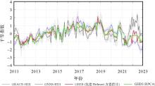
Fig. 5
Regionally averaged time series of the GNSS-HDI and GRACE-HDI as well as the hydrological drought index (GHDI) using Helmert robust variance estimation and RPCA, respectively"

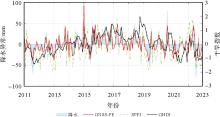
Fig. 6
Regionally averaged time series of precipitation anomalies, the meteorological drought index (GNSS-PE) and the hydrological drought index (GHDI)"

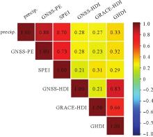
Fig. 7
Correlation coefficients between precipitation anomaly (Precip.)/the meteorological drought indices (GNSS-PE and SPEI) and the hydrological drought indices (GNSS-HDI, GRACE-DSI and GHDI)"


Fig. 8
Regionally averaged time series of the meteorological drought index (GNSS-PE), the hydrological drought index (GHDI) and the composite drought index (CDI)"

| [1] | AGHAKOUCHAK A, FARAHMAND A, MELTON F S, et al. Remote sensing of drought: progress, challenges and opportunities[J]. Reviews of Geophysics, 2015, 53(2): 452-480. |
| [2] | 江笑薇, 白建军, 刘宪峰. 基于多源信息的综合干旱监测研究进展与展望[J]. 地球科学进展, 2019, 34(3): 275-287. |
| JIANG Xiaowei, BAI Jianjun, LIU Xianfeng. Research progress and prospect of integrated drought monitoring based on multi-source information[J]. Advances in Earth Science, 2019, 34(3): 275-287. | |
| [3] | FENG Wei, XIONG Yuhao, YI Shuang, et al. Recent progress on hydrogeodesy in China[J]. Journal of Geodesy and Geoinformation Science, 2023, 6(3): 124-134. |
| [4] | XIAO Yun, YANG Yuanxi, PAN Zongpeng, et al. Chinese gravimetry augment and mass change exploring mission status and future[J]. Journal of Geodesy and Geoinformation Science, 2023, 6(3): 67-75. |
| [5] | BORDI I, RAZIEI T, SANTOS PEREIRA L, et al. Ground-based GPS measurements of precipitable water vapor and their usefulness for hydrological applications[J]. Water Resources Management, 2015, 29(2): 471-486. |
| [6] | ZHAO Qingzhi, MA Xiongwei, YAO Wanqiang, et al. A drought monitoring method based on precipitable water vapor and precipitation[J]. Journal of Climate, 2020, 33(24): 10727-10741. |
| [7] | ZHU Hai, CHEN Kejie, HU Shunqiang, et al. Using the global navigation satellite system and precipitation data to establish the propagation characteristics of meteorological and hydrological drought in Yunnan, China[J]. Water Resources Research, 2023, 59(4): e2022WR033126. |
| [8] | 刘火胜, 姚朝龙, 王瑞丽, 等. 联合GNSS大气可降水量与实测降水的气象干旱监测:以湖北省GNSS站为例[J]. 暴雨灾害, 2025, 44(2): 236-245. |
| LIU Huosheng, YAO Chaolong, WANG Ruili, et al. Meteorological drought monitoring combined with GNSS precipitable water vapor and measured precipitation: a case study of GNSS stations in Hubei province[J]. Torrential Rain and Disasters, 2025, 44(2): 236-245. | |
| [9] | 董前进, 谢平. 水文干旱研究进展[J]. 水文, 2014, 34(4): 1-7. |
| DONG Qianjin, XIE Ping. Advances in hydrological drought research[J]. Journal of China Hydrology, 2014, 34(4): 1-7. | |
| [10] | CHEW C C, SMALL E E. Terrestrial water storage response to the 2012 drought estimated from GPS vertical position anomalies[J]. Geophysical Research Letters, 2014, 41(17): 6145-6151. |
| [11] | FERREIRA V G, MONTECINO H C, NDEHEDEHE C E, et al. Space-based observations of crustal deflections for drought characterization in Brazil[J]. Science of The Total Environment, 2018, 644: 256-273. |
| [12] | JIANG Zhongshan, HSU Y J, YUAN Linguo, et al. Hydrological drought characterization based on GNSS imaging of vertical crustal deformation across the contiguous United States[J]. Science of the Total Environment, 2022, 823: 153663. |
| [13] | 杨兴海, 袁林果, 姜中山, 等. 应用GPS垂向位移定量分析2011—2020年云南省极端干旱时空特征[J]. 地球物理学报, 2022, 65(8): 2828-2843. |
| YANG Xinghai, YUAN Linguo, JIANG Zhongshan, et al. Quantitative analysis of abnormal drought in Yunnan province from 2011 to 2020 using GPS vertical displacement observations[J]. Chinese Journal of Geophysics, 2022, 65(8): 2828-2843. | |
| [14] | CHEN Chao, ZOU Rong, FANG Zhiwei, et al. Using geodetic measurements derived terrestrial water storage to investigate the characteristics of drought in Yunnan, China[J]. GPS Solutions, 2023, 28(1): 51. |
| [15] | PENG Yujie, CHEN Gang, CHAO Nengfang, et al. Detection of extreme hydrological droughts in the Poyang lake basin during 2021—2022 using GNSS-derived daily terrestrial water storage anomalies[J]. Science of the Total Environment, 2024, 919: 170875. |
| [16] | THOMAS B F, FAMIGLIETTI J S, LANDERER F W, et al. GRACE groundwater drought index: evaluation of California Central Valley groundwater drought[J]. Remote Sensing of Environment, 2017, 198: 384-392. |
| [17] | ZHAO Meng, GERUO A, VELICOGNA I, et al. A global gridded dataset of GRACE drought severity index for 2002-14: comparison with PDSI and SPEI and a case study of the Australia millennium drought[J]. Journal of Hydrometeorology, 2017, 18(8): 2117-2129. |
| [18] | 冉艳红, 钟敏, 陈威, 等. 利用GRACE-FO重力卫星探测2019年长江中下游极端干旱[J]. 科学通报, 2021, 66(1): 107-117. |
| RAN Yanhong, ZHONG Min, CHEN Wei, et al. Monitoring the extreme drought in the middle and lower reaches of the Yangtze river in 2019 from GRACE-FO satellites[J]. Chinese Science Bulletin, 2021, 66(1): 107-117. | |
| [19] |
瞿伟, 晋泽辉, 张勤, 等. GRACE与GRACE Follow-On重力卫星数据揭示出的黄河流域2002—2020年干旱特征[J]. 测绘学报, 2023, 52(5): 714-724. DOI: .
doi: 10.11947/j.AGCS.2023.20210458 |
|
QU Wei, JIN Zehui, ZHANG Qin, et al. Drought characteristics of the Yellow river basin from 2002 to 2020 revealed by GRACE and GRACE Follow-On data[J]. Acta Geodaetica et Cartographica Sinica, 2023, 52(5): 714-724. DOI: .
doi: 10.11947/j.AGCS.2023.20210458 |
|
| [20] | 杨大文, 杨汉波, 雷慧闽. 流域水文学[M]. 北京: 清华大学出版社, 2014: 13. |
| YANG Dawen, YANG Hanbo, LEI Huimin. Watershed hydrology[M]. Beijing: Tsinghua University Press, 2014: 13. | |
| [21] |
姚朝龙, 陈涌鑫, 罗志才, 等. GNSS/GRACE/GRACE-FO/气象数据结合反演干旱指数[J]. 测绘学报, 2023, 52(11): 1883-1891. DOI: .
doi: 10.11947/j.AGCS.2023.20220484 |
|
YAO Chaolong, CHEN Yongxin, LUO Zhicai, et al. A drought index derived from a combination of GNSS/GRACE/GRACE-FO and meteorological data[J]. Acta Geodaetica et Cartographica Sinica, 2023, 52(11): 1883-1891. DOI: .
doi: 10.11947/j.AGCS.2023.20220484 |
|
| [22] | ZHU Hai, CHEN Kejie, HU Shunqiang, et al. A novel GNSS and precipitation-based integrated drought characterization framework incorporating both meteorological and hydrological indicators[J]. Remote Sensing of Environment, 2024, 311: 114261. |
| [23] | YAO Chaolong, SHUM C K, LUO Zhicai, et al. An optimized hydrological drought index integrating GNSS displacement and satellite gravimetry data[J]. Journal of Hydrology, 2022, 614: 128647. |
| [24] | 杨元喜. 抗差估计理论及其应用[M]. 北京: 八一出版社, 1993. |
| YANG Yuanxi. Robust estimation theory and its applications[M]. Beijing: Bayi Publishing House, 1993. | |
| [25] | 王志伟, 陈时军, 曲国庆. 基于抗差方差分量估计多源观测数据融合权比的确定[J]. 工程勘察, 2014, 42(7): 69-72. |
| WANG Zhiwei, CHEN Shijun, QU Guoqing. Weight determination of multi-source data fusion based on robust variance component estimation[J]. Geotechnical Investigation & Surveying, 2014, 42(7): 69-72. | |
| [26] | WRIGHT J, GANESH A, RAO S, et al. Robust principal component analysis: exact recovery of corrupted low-rank matrices via convex optimization[C]//Proceedings of the 22nd International Conference on Neural Information Processing Systems. [S.l.]: Curvan Associates, Inc, 2009: 2080-2088. |
| [27] | 胡乘其, 王书朋, 王瑜婧. 基于鲁棒性主成分分析的低照度图像增强算法[J]. 计算机应用与软件, 2024, 41(2): 244-249. |
| HU Chengqi, WANG Shupeng, WANG Yujing. Low-light image enhancement algorithm based on robust principal component analysis[J]. Computer Applications and Software, 2024, 41(2): 244-249. | |
| [28] | 张迎, 黄生志, 黄强, 等. 基于Copula函数的新型综合干旱指数构建与应用[J]. 水利学报, 2018, 49(6): 703-714. |
| ZHANG Ying, HUANG Shengzhi, HUANG Qiang, et al. Construction and application of a new comprehensive drought index based on Copula function[J]. Journal of Hydraulic Engineering, 2018, 49(6): 703-714. | |
| [29] | 杨辰飞, 吴田军, 王长鹏, 等. 基于Copula函数的千米尺度综合干旱指数构建与应用:以重庆市为例[J]. 自然资源遥感, 2024, 36(3): 117-127. |
| YANG Chenfei, WU Tianjun, WANG Changpeng, et al. Construction and application of a comprehensive drought index based on Copula function on a kilometer scale: a case study of Chongqing, China[J]. Remote Sensing for Natural Resources, 2024, 36(3): 117-127. | |
| [30] | SUO Nanji, XU Changchun, CAO Linlin, et al. A copula-based parametric composite drought index for drought monitoring and applicability in arid Central Asia[J]. Catena, 2024, 235: 107624. |
| [31] | 赵勇, 翟家齐, 蒋桂芹, 等. 干旱驱动机制与模拟评估[M]. 北京: 科学出版社, 2017: 7. |
| ZHAO Yong, ZHAI Jiaqi, JIANG Guiqin, et al. Drought driving mechanism and simulation evaluation[M]. Beijing: Science Press, 2017: 7. | |
| [32] | 李博峰, 沈云中, 楼立志. 基于等效残差的方差-协方差分量估计[J]. 测绘学报, 2010, 39(4): 349-354. |
| LI Bofeng, SHEN Yunzhong, LOU Lizhi. Variance-covariance component estimation based on the equivalent residuals[J]. Acta Geodaetica et Cartographica Sinica, 2010, 39(4): 349-354. | |
| [33] | 简海方, 石雨燕, 雷新强, 等. 用于地壳运动速度场拟合分析的隶属度函数改进IGGⅢ抗差方法[J]. 大地测量与地球动力学, 2025, 45(5): 545-550. |
| JIAN Haifang, SHI Yuyan, LEI Xinqiang, et al. Improved IGGⅢ robust method with membership function for crustal movement velocity field fitting and analysis[J]. Journal of Geodesy and Geodynamics, 2025, 45(5): 545-550. | |
| [34] | 刘长建, 吴洪举, 明锋. Helmert方差分量估计严密公式与简化公式等价性的证明[J]. 测绘科学, 2006, 31(2): 66-67. |
| LIU Changjian, WU Hongju, MING Feng. Equivalence of rigorous formula to simplified formula of helmert variance components estimation[J]. Science of Surveying and Mapping, 2006, 31(2): 66-67. | |
| [35] | YANG Yuanxi, XU Tianhe, SONG Lijie. Robust estimation of variance components with application in global positioning system network adjustment[J]. Journal of Surveying Engineering, 2005, 131(4): 107-112. |
| [36] | LIN Xiaohong, WANG Han, GAO Jingyang. ScIALM: a method for sparse scRNA-seq expression matrix imputation using the inexact augmented Lagrange multiplier with low error[J]. Computational and Structural Biotechnology Journal, 2004(23): 549-558. |
| [1] | Jiachao BIAN, Shuqiang XUE, Shuang ZHAO, Jixing ZHU, Jinlai GAO, Baojin LI. Multi-window joint robust estimation for marine acoustic navigation [J]. Acta Geodaetica et Cartographica Sinica, 2026, 55(3): 515-524. |
| [2] | Jiancheng LI, Yunlong WU, Yibing YAO, Zhicai LUO. Satellite gravity technology oriented towards data-scenario-model driven approach: developments, challenges and outlook [J]. Acta Geodaetica et Cartographica Sinica, 2025, 54(9): 1537-1560. |
| [3] | Xuli TAN, Shanshan LI, Zhiyong HUANG, Zongpeng PAN, Diao FAN, Hongfa WAN, Xianyong PEI, Zhenbang XU. Construction and analysis of the static gravity field model based on ChiGaM satellite [J]. Acta Geodaetica et Cartographica Sinica, 2025, 54(10): 1798-1811. |
| [4] | Gen LI, Hongzhou CHAI, Kaidi JIN, Zhao ZHAN. Underwater terrain matching method based on robust particle filter [J]. Acta Geodaetica et Cartographica Sinica, 2025, 54(10): 1841-1851. |
| [5] | KUANG Yingcai, Lü Zhiping, LI Linyang, WANG Fangchao, XU Guochang. Dynamic nolinear Gauss-Helmert model and its robust total Kalman filter algorithm for GNSS-acoustic underwater positioning [J]. Acta Geodaetica et Cartographica Sinica, 2023, 52(4): 559-570. |
| [6] | WANG Zeming, LI Haojun, SUN Yafeng. Robust estimation of GNSS-R tide level monitoring [J]. Acta Geodaetica et Cartographica Sinica, 2023, 52(2): 195-205. |
| [7] | SUN Yue, XUE Shuqiang, HAN Baomin, XIAO Zhen. Multi-station joint processing model for seafloor geodetic coordinate time series [J]. Acta Geodaetica et Cartographica Sinica, 2023, 52(11): 1835-1843. |
| [8] | LI Jiayuan, ZHANG Yongjun, AI Mingyao, HU Qingwu. Scale-adaptive Cauchy robust estimation based on progressive optimization and its applications [J]. Acta Geodaetica et Cartographica Sinica, 2023, 52(1): 61-70. |
| [9] | HAO Yushi, SUN Jianwei, SUI Xin, XU Aigong, SHI Chuang. Multi-GNSS RTK/INS tightly coupled integrated navigation method considering ISB/IFB estimation [J]. Acta Geodaetica et Cartographica Sinica, 2022, 51(11): 2265-2272. |
| [10] | YANG Gaochao, WANG Qing, YU Baoguo, LIU Pengfei, LI Shuang. High-precision indoor positioning based on robust LM visual inertial odometer and pseudosatellite [J]. Acta Geodaetica et Cartographica Sinica, 2022, 51(1): 18-30. |
| [11] | GUO Yinggang, LI Zongchun, HE Hua, WANG Zhiying. A simplex search algorithm for the optimal weight of common point of 3D coordinate transformation [J]. Acta Geodaetica et Cartographica Sinica, 2020, 49(8): 1004-1013. |
| [12] | BU Lijing, ZHENG Xinjie, ZHANG Zhengpeng. Super-resolution reconstruction of “straring” satellite video motion scene considering motion estimation error [J]. Acta Geodaetica et Cartographica Sinica, 2020, 49(2): 214-224. |
| [13] | YIN Xiao, CHAI Hongzhou, XIANG Minzhi, DU Zhenqiang. Robust UKF algorithm with motion constraint in BDS navigation [J]. Acta Geodaetica et Cartographica Sinica, 2020, 49(11): 1399-1406. |
| [14] | ZHAO Chaoying, WANG Baohang. SAR interferogram denoising based on robust covariance matrix decomposition [J]. Acta Geodaetica et Cartographica Sinica, 2019, 48(1): 24-33. |
| [15] | ZOU Xiancai. Calibration of the Satellite Gravity Gradients for GOCE and Analysis on Its Drag Free Control System [J]. Acta Geodaetica et Cartographica Sinica, 2018, 47(3): 291-297. |
| Viewed | ||||||
|
Full text |
|
|||||
|
Abstract |
|
|||||