

Acta Geodaetica et Cartographica Sinica ›› 2025, Vol. 54 ›› Issue (12): 2107-2115.doi: 10.11947/j.AGCS.2025.20250438
• Review • Next Articles
Deren LI1( ), Mi WANG1,2(), Wenbin SHEN1,3, Qingyun DU4, Shuo WANG1
Received:2025-10-19
Revised:2025-11-25
Online:2026-01-15
Published:2026-01-15
Contact:
Mi WANG
E-mail:drli@whu.edu.cn;wangmi@whu.edu.cn
About author:LI Deren (1939—), male, professor, academician of Chinese Academy of Sciences and Chinese Academy of Engineering, majors in the theory and methods of geospatial informatics. E-mail: drli@whu.edu.cn
Supported by:CLC Number:
Deren LI, Mi WANG, Wenbin SHEN, Qingyun DU, Shuo WANG. On the development of surveying and mapping in the era of artificial intelligence[J]. Acta Geodaetica et Cartographica Sinica, 2025, 54(12): 2107-2115.
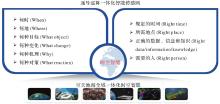
Fig. 1
Core system of spatio-temporal intelligence"

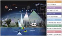
Fig. 2
Application domains of spatio-temporal intelligence"
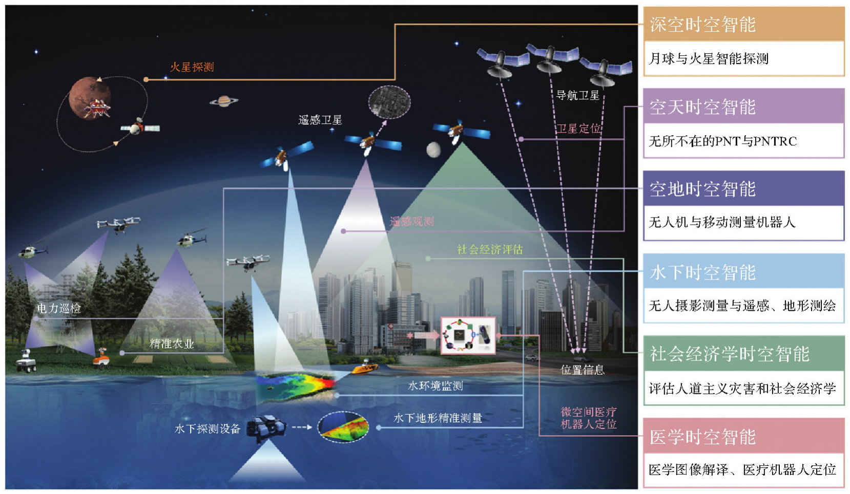
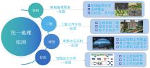
Fig. 3
The composition elements of the “National One Map”"

Tab. 1
Comparison of the characteristics of city-level real-scene 3D data"
| 评价维度 | 考量因子 | Mesh模型 | 单体化模型 | LOD1.3级模型 | 属性设色三维模型 |
|---|---|---|---|---|---|
| 美观性 | 可视化效果 | ★★★★ | ★★★★☆ | ★★ | ★★★ |
| 易用性 | 数据量大小、属性挂接、平台支持 | ★★ | ★★★★ | ★★★★ | ★★★★ |
| 应用性 | 支撑应用场景是否广泛 | ★★★★ | ★★★★ | ★★★ | ★★★☆ |
| 经济性 | 自动化程度、成本高低 | ★★★ | ☆ | ★★★★ | ★★★★★ |
| 易维护性 | 数据更新难易程度 | ☆ | ★★★☆ | ★★★★★ | ★★★★★ |
| 生产成本/(元/km2) | 8000~10 000 | 30 000~40 000 | 3000 | 1500 | |
| [1] | LI Deren, WANG Mi, JIANG Jie. China's high-resolution optical remote sensing satellites and their mapping applications[J]. Geo-spatial Information Science, 2021, 24(1): 85-94. |
| [2] |
陈军, 艾廷华, 闫利, 等. 智能化测绘的混合计算范式与方法研究[J]. 测绘学报, 2024, 53(6): 985-998. DOI: .
doi: 10.11947/j.AGCS.2024.20240131 |
|
CHEN Jun, AI Tinghua, YAN Li, et al. Hybrid computational paradigm and methods for intelligentized surveying and mapping[J]. Acta Geodaetica et Cartographica Sinica, 2024, 53(6): 985-998. DOI: .
doi: 10.11947/j.AGCS.2024.20240131 |
|
| [3] | 杨必胜, 陈一平, 邹勤. 从大模型看测绘时空信息智能处理的机遇和挑战[J]. 武汉大学学报(信息科学版), 2023, 48(11): 1756-1768. |
| YANG Bisheng, CHEN Yiping, ZOU Qin. Opportunities and challenges of spatiotemporal information intelligent processing of surveying and mapping in the era of large models[J]. Geomatics and Information Science of Wuhan University, 2023, 48(11): 1756-1768. | |
| [4] | 白洁. 李德仁院士:推动测绘遥感走向时空智能[J]. 中国测绘, 2024(10): 9-11. |
| BAI Jie. Academician Li Deren: promoting surveying and remote sensing toward spatio-temporal intelligence[J]. China Surveying and Mapping, 2024(10): 9-11. | |
| [5] |
郝彧露. 时空数据驱动的城市区域火灾风险评估预测模型及应用[J]. 测绘学报, 2025, 54(10): 1910. DOI: .
doi: 10.11947/j.AGCS.2025.20240051 |
|
HAO Yulu. Spatio-temporal data-driven city-level fire risk assessment and prediction modeling and applications[J]. Acta Geodaetica et Cartographica Sinica, 2025, 54(10): 1910. DOI: .
doi: 10.11947/j.AGCS.2025.20240051 |
|
| [6] |
李德仁, 徐小迪, 邵振峰. 论万物互联时代的地球空间信息学[J]. 测绘学报, 2022, 51(1): 1-8. DOI: .
doi: 10.11947/j.AGCS.2022.20210564 |
|
LI Deren, XU Xiaodi, SHAO Zhenfeng. On geospatial information science in the era of IoE[J]. Acta Geodaetica et Cartographica Sinica, 2022, 51(1): 1-8. DOI: .
doi: 10.11947/j.AGCS.2022.20210564 |
|
| [7] | BANAEIAN FAR S, IMANI RAD A. Internet of artificial intelligence (IoAI): the emergence of an autonomous, generative, and fully human-disconnected community[J]. Discover Applied Sciences, 2024, 6(3): 91. |
| [8] |
王密, 程昫, 潘俊, 等. 大模型赋能智能摄影测量:现状、挑战与前景[J]. 测绘学报, 2024, 53(10): 1955-1966. DOI: .
doi: 10.11947/j.AGCS.2024.20240068 |
|
WANG Mi, CHENG Xu, PAN Jun, et al. Large models enabling intelligent photogrammetry: status, challenges and prospects[J]. Acta Geodaetica et Cartographica Sinica, 2024, 53(10): 1955-1966. DOI: .
doi: 10.11947/j.AGCS.2024.20240068 |
|
| [9] | 龚健雅. 人工智能时代测绘遥感技术的发展机遇与挑战[J]. 武汉大学学报(信息科学版), 2018, 43(12): 1788-1796. |
| GONG Jianya. Chances and challenges for development of surveying and remote sensing in the age of artificial intelligence[J]. Geomatics and Information Science of Wuhan University, 2018, 43(12): 1788-1796. | |
| [10] |
张广运, 张荣庭, 戴琼海, 等. 测绘地理信息与人工智能2.0融合发展的方向[J]. 测绘学报, 2021, 50(8): 1096-1108. DOI: .
doi: 10.11947/j.AGCS.2021.20210200 |
|
ZHANG Guangyun, ZHANG Rongting, DAI Qionghai, et al. The direction of integration surveying and mapping geographic information and artificial intelligence 2.0[J]. Acta Geodaetica et Cartographica Sinica, 2021, 50(8): 1096-1108. DOI: .
doi: 10.11947/j.AGCS.2021.20210200 |
|
| [11] | 李德仁, 眭海刚, 张浩, 等. 时空智能助力应急监测的思考与探索[J]. 中国减灾, 2025(1): 16-17. |
| LI Deren, SUI Haigang, ZHANG Hao, et al. Thoughts and explorations on spatio-temporal intelligence assisting emergency monitoring[J]. Disaster Reduction in China, 2025(1): 16-17. | |
| [12] | 李德仁, 王密, 肖晶, 等. 论无所不在的时空智能[J]. 遥感学报, 2025, 29(6): 1388-1398. |
| LI Deren, WANG Mi, XIAO Jing, et al. On ubiquitous spatio-temporal intelligence[J]. National Remote Sensing Bulletin, 2025, 29(6): 1388-1398. | |
| [13] | 杨元喜, 明锋. 中国时空基准建设现状与未来发展[J]. 中国科学:地球科学, 2023, 53(9): 2192-2195. |
| YANG Yuanxi, MING Feng. Current status and future development of spatiotemporal datum construction in China[J]. Scientia Sinica (Terrae), 2023, 53(9): 2192-2195. | |
| [14] | 孙和平, 杨元喜, 叶朝辉, 等. 精密(量子)测量时代下时空基准研究中的关键科学问题和核心技术[J]. 中国科学基金, 2024, 38(1): 172-181. |
| SUN Heping, YANG Yuanxi, YE Zhaohui, et al. Key scientific frontiers and core technologies in space-time reference research in the era of precision (quantum) measurement[J]. Bulletin of National Natural Science Foundation of China, 2024, 38(1): 172-181. | |
| [15] | 李德仁, 王密, 仵倩玉. 论智能遥感卫星的“快、准、灵”应用服务[J]. 先进小卫星技术(中英文), 2024(1): 1-9. |
| LI Deren, WANG Mi, WU Qianyu. Fast, accurate and smart applications of intelligent remote sensing satellites[J]. Advanced Small Satellite Technology, 2024(1): 1-9. | |
| [16] | 王密, 杨博, 李德仁, 等. 资源三号全国无控制整体区域网平差关键技术及应用[J]. 武汉大学学报(信息科学版), 2017, 42(4): 427-433. |
| WANG Mi, YANG Bo, LI Deren, et al. Technologies and applications of block adjustment without control for ZY-3 images covering China[J]. Geomatics and Information Science of Wuhan University, 2017, 42(4): 427-433. | |
| [17] | 王密, 韦钰, 杨博, 等. ICESat-2/ATLAS全球高程控制点提取与分析[J]. 武汉大学学报(信息科学版), 2021, 46(2): 184-192. |
| WANG Mi, WEI Yu, YANG Bo, et al. Extraction and analysis of global elevation control points from ICESat-2/ATLAS data[J]. Geomatics and Information Science of Wuhan University, 2021, 46(2): 184-192. | |
| [18] |
贺彪, 郭仁忠, 徐海, 等. 智慧城市操作系统的概念及技术体系[J]. 测绘学报, 2025, 54(5): 785-794. DOI: .
doi: 10.11947/j.AGCS.2025.20240120 |
|
HE Biao, GUO Renzhong, XU Hai, et al. Concept and technical system of smart city operating system[J]. Acta Geodaetica et Cartographica Sinica, 2025, 54(5): 785-794. DOI: .
doi: 10.11947/j.AGCS.2025.20240120 |
|
| [19] | 宫晓曼. 基于人工智能技术的城市大脑中的智能交通系统研究[J]. 人民公交, 2024(18): 114-116. |
| GONG Xiaoman. Research on intelligent transportation system in urban brain based on artificial intelligence technology[J]. People's Public Transportation, 2024(18): 114-116. | |
| [20] |
吴华意, 沈张骁, 侯树洋, 等. 大语言模型驱动的GIS分析:方法、应用与展望[J]. 测绘学报, 2025, 54(4): 621-635. DOI: .
doi: 10.11947/j.AGCS.2025.20240468 |
|
WU Huayi, SHEN Zhangxiao, HOU Shuyang, et al. Large language model-driven GIS analysis: methods, applications, and prospects[J]. Acta Geodaetica et Cartographica Sinica, 2025, 54(4): 621-635. DOI: .
doi: 10.11947/j.AGCS.2025.20240468 |
|
| [21] |
龚健雅, 乐鹏, 向隆刚, 等. 开放地球引擎OGE设计与研制[J]. 测绘学报, 2025, 54(4): 587-602. DOI: .
doi: 10.11947/j.AGCS.2025.20250051 |
|
GONG Jianya, YUE Peng, XIANG Longgang, et al. The design and implementation of the open geospatial engine (OGE)[J]. Acta Geodaetica et Cartographica Sinica, 2025, 54(4): 587-602. DOI: .
doi: 10.11947/j.AGCS.2025.20250051 |
|
| [22] | 黄蔚, 张红平, 徐永, 等. 国家地理信息公共服务平台(天地图)建设的若干思考[J]. 测绘通报, 2024(4): 145-149, 155. |
| HUANG Wei, ZHANG Hongping, XU Yong, et al. Some thoughts on the national platform for common geospatial information services (Tianditu)[J]. Bulletin of Surveying and Mapping, 2024(4): 145-149, 155. |
| [1] | Yanhui CAI, Pengfei CHENG, Li ZHANG. Inspection capacity index (ICI)—a sampling scheme measure of quality inspection of surveying and mapping products [J]. Acta Geodaetica et Cartographica Sinica, 2025, 54(3): 473-480. |
| [2] | Yuanxi YANG. Digital twin and spatio-temporal intelligence of geospatial information system [J]. Acta Geodaetica et Cartographica Sinica, 2025, 54(2): 213-220. |
| [3] | Jun CHEN, Tinghua AI, Li YAN, Wanzeng LIU, Zhilin LI, Qiang ZHU, Jingxiang GAO, Hong XIE, Hao WU, Jun ZHANG. Hybrid computational paradigm and methods for intelligentized surveying and mapping [J]. Acta Geodaetica et Cartographica Sinica, 2024, 53(6): 985-998. |
| [4] | Dong WEI, Xinyi LIU, Yongjun ZHANG. The technology and intelligent development of 3D line cloud reconstruction from multiple images [J]. Acta Geodaetica et Cartographica Sinica, 2024, 53(6): 1025-1036. |
| [5] | Zhilin LI, Zhu XU, Li SHEN, Jingzhong LI, Tian LAN, Jicheng WANG, Tingting ZHAO, Tinghua AI, Peng TI, Wanzeng LIU, Jun CHEN. Autonomous situatedness map representation: a theoretical discussion on intelligent cartography in the era of large models [J]. Acta Geodaetica et Cartographica Sinica, 2024, 53(11): 2043-2052. |
| [6] | REN Jiaxin, LIU Wanzeng, CHEN Jun, ZHANG Lan, TAO Yuan, ZHU Xiuli, ZHAO Tingting, LI Ran, ZHAI Xi, WANG Haiqing, ZHOU Xiaoguang, HOU Dongyang, WANG Yong. Knowledge-guided intelligent recognition of the scale for fragmented raster topographic maps [J]. Acta Geodaetica et Cartographica Sinica, 2024, 53(1): 146-157. |
| [7] | ZHANG Jixian, LIU Fei. Review of visual SLAM environment perception technology and intelligent surveying and mapping application [J]. Acta Geodaetica et Cartographica Sinica, 2023, 52(10): 1617-1630. |
| [8] | YANG Bisheng, CHEN Chi, DONG Zhen. 3D geospatial information extraction of urban objects for smart surveying and mapping [J]. Acta Geodaetica et Cartographica Sinica, 2022, 51(7): 1476-1484. |
| [9] | TANG Xinming, WANG Hongyan. Establishment and application of China civil optical satellite surveying and mapping products [J]. Acta Geodaetica et Cartographica Sinica, 2022, 51(7): 1386-1397. |
| [10] | GUO Huadong, WU Wenjin, ZHANG Ke, LI Xinwu. New generation SAR for Earth environment observation [J]. Acta Geodaetica et Cartographica Sinica, 2022, 51(6): 862-872. |
| [11] | YANG Yuanxi, REN Xia, WANG Jianrong. Development of integrated and intelligent surveying and mapping satellite project with corresponding key technology [J]. Acta Geodaetica et Cartographica Sinica, 2022, 51(6): 854-861. |
| [12] | ZHANG Guangyun, ZHANG Rongting, DAI Qionghai, CHEN Jun, PAN Yunhe. The direction of integration surveying and mapping geographic information and artificial intelligence 2.0 [J]. Acta Geodaetica et Cartographica Sinica, 2021, 50(8): 1096-1108. |
| [13] | HAO Tong, WANG Xiaofeng, FENG Tiantian, LU Ping, QIAO Gang, XIE Huan, LI Rongxing. Intelligent and multi-scale surveying of key areas and processes of the Earth system [J]. Acta Geodaetica et Cartographica Sinica, 2021, 50(8): 1084-1095. |
| [14] | CHEN Jun, LIU Wanzeng, WU Hao, LI Songnian, YAN Li. Smart surveying and mapping: fundamental issues and research agenda [J]. Acta Geodaetica et Cartographica Sinica, 2021, 50(8): 995-1005. |
| [15] | LI Tao, TANG Xinming, GAO Xiaoming, CHEN Qianfu, ZHANG Xiang. Analysis and outlook of the operational topographic surveying and mapping capability of the SAR satellites [J]. Acta Geodaetica et Cartographica Sinica, 2021, 50(7): 891-904. |
| Viewed | ||||||
|
Full text |
|
|||||
|
Abstract |
|
|||||