

Acta Geodaetica et Cartographica Sinica ›› 2025, Vol. 54 ›› Issue (4): 749-759.doi: 10.11947/j.AGCS.2025.20240123
• Photogrammetry and Remote Sensing • Previous Articles Next Articles
Weilian LI1,2( ), Jun ZHU1(), Qing ZHU1, Jialuo LI1
Received:2024-03-29
Online:2025-05-30
Published:2025-05-30
Contact:
Jun ZHU
E-mail:vgewilliam@163.com;zhujun@swjtu.edu.cn
About author:LI Weilian (1993—), male, PhD, associate researcher, majors in virtual geographical environment and 3D visualization. E-mail: vgewilliam@163.com
Supported by:CLC Number:
Weilian LI, Jun ZHU, Qing ZHU, Jialuo LI. A 3D modelling method for temperature field of mountain bridges coupled with numerical simulation and spatio-temporal interpolation fusion[J]. Acta Geodaetica et Cartographica Sinica, 2025, 54(4): 749-759.
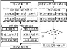
Fig. 1
Numerical simulation calculation process of temperature field of mountain bridges"

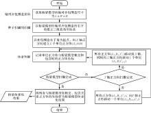
Fig. 2
Bridge model voxelization process"

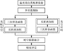
Fig. 3
Spatio-temporal interpolation fusion modelling method for temperature field of mountain bridges"
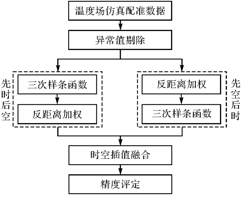
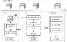
Fig. 4
Temperature field volume rendering based on ray casting"

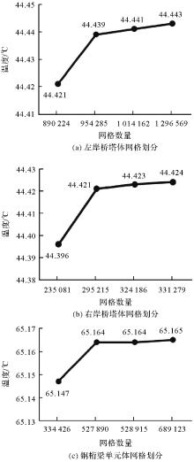
Fig. 5
The correlation between mesh division of bridge models and temperature variation"


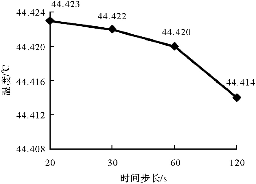
Fig. 6
The correlation between time step and temperature variation"
Tab. 1
The temperature field simulation results of mountainous bridges"
| 模型 | 最高温度/℃ | 平均最高温度/℃ | 温差/℃ |
|---|---|---|---|
| 左岸桥塔 | 47.75 | 27.00 | 20.75 |
| 右岸桥塔 | 44.42 | 29.03 | 15.39 |
| 钢桁梁单元 | 65.16 | 37.41 | 27.75 |
Fig. 7
Simulation results of bridge temperature field"
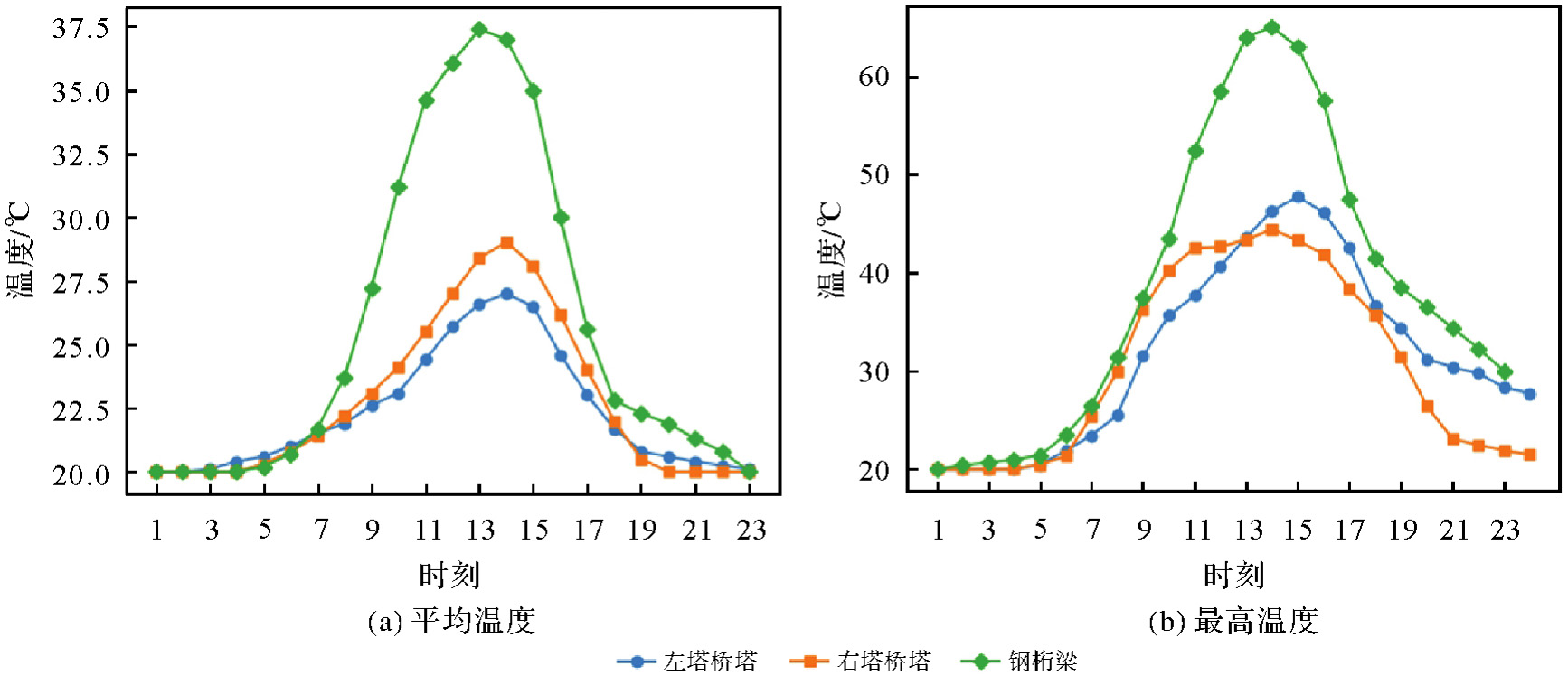
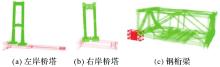
Fig. 8
Position, orientation and scale of temperature field simulation data before registration"

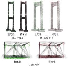
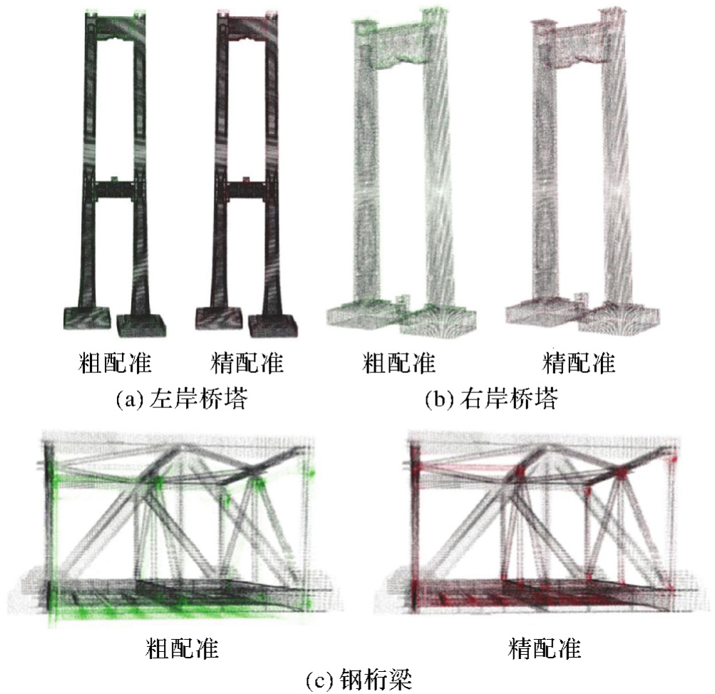
Fig. 9
Registration results of bridge tower and steel truss girder temperature simulation"
Tab. 2
Root mean square error of interpolation results"
| 方法 | 左岸桥塔 | 右岸桥塔 | 钢桁梁单元 |
|---|---|---|---|
| 时空插值融合 | 0.004 97 | 0.005 24 | 0.004 98 |
| 时间插值 | 0.007 51 | 0.006 13 | 0.005 86 |
| 空间插值 | 0.005 41 | 0.005 68 | 0.005 31 |
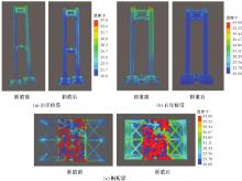
Fig. 10
Temperature values of bridge components before and after spatio-temporal interpolation fusion"

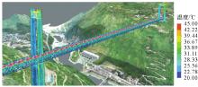
Fig. 11
Volume rendering of bridge temperature field"
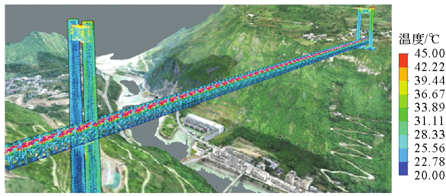
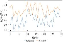
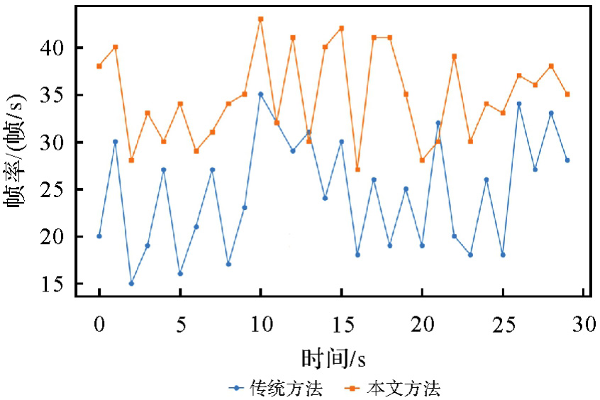
Fig. 12
Rendering frame rate of bridge temperature field"
| [1] | 勾红叶, 杨彪, 华辉, 等. 桥梁信息化及智能桥梁2019年度研究进展[J]. 土木与环境工程学报(中英文), 2020, 42(5): 14-27. |
| GOU Hongye, YANG Biao, HUA Hui, et al. State-of-the-art review of bridge informatization and intelligent bridge in 2019[J]. Journal of Civil and Environmental Engineering, 2020, 42(5): 14-27. | |
| [2] | 王同军. 铁路桥梁智能建造关键技术研究[J]. 中国铁路, 2021(9): 1-10. |
| WANG Tongjun. Research on key technologies for intelligent construction of railway bridge[J]. China Railway, 2021(9): 1-10. | |
| [3] | ZHOU Xuhong, ZHANG Xigang. Thoughts on the development of bridge technology in China[J]. Engineering, 2019, 5(6): 1120-1130. |
| [4] | LI Weilian, ZHU Jun, DANG Pei, et al. Immersive virtual reality as a tool to improve bridge teaching communication[J]. Expert Systems with Applications, 2023, 217: 119502. |
| [5] | 卢春房, 蔡超勋. 川藏铁路工程建设安全面临的挑战与对策[J]. 建设机械技术与管理, 2020, 33(2): 28-34. |
| LU Chunfang, CAI Chaoxun. Challenges and countermeasures for construction safety during the Sichuan-Xizang railway project[J]. Construction Machinery Technology & Management, 2020, 33(2): 28-34. | |
| [6] | 朱军, 朱庆, 祝兵, 等. 数字孪生驱动的桥梁智能建造方法[J]. 遥感学报, 2024, 28(5): 1340-1349. |
| ZHU Jun, ZHU Qing, ZHU Bing, et al. Intelligent bridge construction method driven by digital twin[J]. National Remote Sensing Bulletin, 2024, 28(5): 1340-1349. | |
| [7] | 刘纪平, 刘猛猛, 徐胜华, 等. 大数据时代下的一体化综合减灾技术综述[J]. 武汉大学学报(信息科学版), 2020, 45(8): 1107-1116. |
| LIU Jiping, LIU Mengmeng, XU Shenghua, et al. A survey on integrated and comprehensive disaster reduction technology in the era of big data[J]. Geomatics and Information Science of Wuhan University, 2020, 45(8): 1107-1116. | |
| [8] |
朱庆, 张利国, 丁雨淋, 等. 从实景三维建模到数字孪生建模[J]. 测绘学报, 2022, 51(6): 1040-1049. DOI:.
doi: 10.11947/j.AGCS.2022.20210640 |
|
ZHU Qing, ZHANG Liguo, DING Yulin, et al. From real 3D modeling to digital twin modeling[J]. Acta Geodaetica et Cartographica Sinica, 2022, 51(6): 1040-1049. DOI:.
doi: 10.11947/j.AGCS.2022.20210640 |
|
| [9] | 刘伟涛, 房志明, 郑梓怡, 等. 基于多元线性回归桥梁温度响应预测研究[J]. 建模与仿真, 2024, 13(6): 6000-6008. |
| LIU Weitao, FANG Zhiming, ZHENG Ziyi, et al. Prediction study of bridge temperature response based on multiple linear regression[J]. Modeling and Simulation, 2024, 13(6): 6000-6008. | |
| [10] | 董旭, 邓振全, 李树忱, 等. 大跨波形钢腹板箱梁桥日照温度场及温差效应研究[J]. 工程力学, 2017, 34(9): 230-238. |
| DONG Xu, DENG Zhenquan, LI Shuchen, et al. Research on sun light temperature field and thermal difference effect of long span box girder bridge with corrugated steel webs[J]. Engineering Mechanics, 2017, 34(9): 230-238. | |
| [11] | 魏欣宇. 高海拔山区中小跨度铁路钢-砼结合梁温度效应和结构优化研究[D]. 成都: 西南交通大学, 2021. |
| WEI Xinyu. Study on temperature effect and structural optimization of steel concrete composite beam for medium and small span railway in high altitude mountainous area[D]. Chengdu: Southwest Jiaotong University, 2021. | |
| [12] | 张宸瑜. 钢板组合梁桥日照非均匀温度场及温度效应研究[D]. 西安: 长安大学, 2021. |
| ZHANG Chenyu. Non-uniform temperature field and thermal effect of steel-concrete composite I-Girder bridges under solar radiation[D]. Xi'an: Chang'an University, 2021. | |
| [13] | 李全林. 日照下混凝土箱梁温度场和温度应力研究[D]. 长沙: 湖南大学, 2004. |
| LI Quanlin. Research of temperature field & temperature stress of concrete box girder caused by the solar radiation[D]. Changsha: Hunan University, 2004. | |
| [14] | MIAO Changqing, SHI Changhua. Temperature gradient and its effect on flat steel box girder of long-span suspension bridge[J]. Science China Technological Sciences, 2013, 56(8): 1929-1939. |
| [15] | ABID S R, TAYŞI N, ÖZAKÇA M. Experimental analysis of temperature gradients in concrete box-girders[J]. Construction and Building Materials, 2016, 106: 523-532. |
| [16] | ZHOU Guangdong, YI Tinghua. Thermal load in large-scale bridges: a state-of-the-art review[J]. International Journal of Distributed Sensor Networks, 2013, 9(12): 217983. |
| [17] | ZHOU Linren, XIA Yong, BROWNJOHN J M W, et al. Temperature analysis of a long-span suspension bridge based on field monitoring and numerical simulation[J]. Journal of Bridge Engineering, 2016, 21(1): 04015027. |
| [18] | 王虎, 陈翔, 王雅. 桥面铺装层温度场的有限元模拟及剪应力分布分析[J]. 徐州工程学院学报(自然科学版), 2020, 35(1): 32-36. |
| WANG Hu, CHEN Xiang, WANG Ya. Finite element simulation of temperature field and shear stress distribution analysis of bridge deck pavement[J]. Journal of Xuzhou Institute of Technology (Natural Sciences Edition), 2020, 35(1): 32-36. | |
| [19] | 薛仪. 基于气象共享数据的混凝土箱型梁桥温度场分析方法[D]. 广州: 华南理工大学, 2020. |
| XUE Yi. Analysis method of temperature field of concrete boxgirder bridge based on shared weather data[D]. Guangzhou: South China University of Technology, 2020. | |
| [20] | POUGET S, SAUZÉAT C, DI BENEDETTO H, et al. Modeling of viscous bituminous wearing course materials on orthotropic steel deck[J]. Materials and Structures, 2012, 45(7): 1115-1125. |
| [21] | 自然资源部办公厅. 全面推进实景三维中国建设的通知[EB/OL]. [2024-02-20]. http://gi.mnr.gov.cn/202202/t20220225_2729401.html. |
| General Office of the Ministry of Natural Resources. Notice on comprehensively promoting the construction of China's 3D realistic geospatial scene[EB/OL]. [2024-02-20]. http://gi.mnr.gov.cn/202202/t20220225_2729401.html. | |
| [22] | 姚巍, 王谱佐. 实景三维技术发展态势——ⅩⅪⅤ ISPRS Congress报告[J]. 时空信息学报, 2023, 30(2): 167-176. |
| YAO Wei, WANG Puzuo. Development trend analysis of real-scene 3D technology: ⅩⅪⅤ ISPRS congress report[J]. Journal of Spatio-temporal Information, 2023, 30(2): 167-176. | |
| [23] | 陈军, 刘建军, 田海波. 实景三维中国建设的基本定位与技术路径[J]. 武汉大学学报(信息科学版), 2022, 47(10): 1568-1575. |
| CHEN Jun, LIU Jianjun, TIAN Haibo. Basic directions and technological path for building 3D realistic geospatial scene in China[J]. Geomatics and Information Science of Wuhan University, 2022, 47(10): 1568-1575. | |
| [24] | 陈军, 王艳慧, 武昊, 等. 时空信息赋能高质量发展的基本问题与发展方向[J]. 时空信息学报, 2023, 30(1): 1-11. |
| CHEN Jun, WANG Yanhui, WU Hao, et al. Basic issues and development directions of high-quality development empowered by spatio-temporal information[J]. Journal of Spatio-temporal Information, 2023, 30(1): 1-11. | |
| [25] | 朱庆, 李函侃, 曾浩炜, 等. 面向数字孪生川藏铁路的实体要素分类与编码研究[J]. 武汉大学学报(信息科学版), 2020, 45(9): 1319-1327. |
| ZHU Qing, LI Hankan, ZENG Haowei, et al. Classification and coding of entity features for digital twin Sichuan-Xizang railway[J]. Geomatics and Information Science of Wuhan University, 2020, 45(9): 1319-1327. | |
| [26] |
杨高朝, 王庆, 蔚保国, 等. 基于抗差LM的视觉惯性里程计与伪卫星混合高精度室内定位[J]. 测绘学报, 2022, 51(1): 18-30. DOI:.
doi: 10.11947/j.AGCS.2022.20200251 |
|
YANG Gaochao, WANG Qing, YU Baoguo, et al. High-precision indoor positioning based on robust LM visual inertial odometer and pseudosatellite[J]. Acta Geodaetica et Cartographica Sinica, 2022, 51(1): 18-30. DOI:.
doi: 10.11947/j.AGCS.2022.20200251 |
|
| [27] | ZHANG Heng, ZHAO Wen, HAN Zujie, et al. Knowledge-guided digital twin modeling method of generating hierarchical scenes for a high-speed railway[J]. Transactions in GIS, 2023, 27(7): 2017-2041. |
| [28] | 朱军, 赖建波, 谢亚坤, 等. 知识引导的桥梁建造过程时空叙事三维可视化方法[J]. 武汉大学学报(信息科学版), 2024, 49(9): 1650-1660. |
| ZHU Jun, LAI Jianbo, XIE Yakun, et al. Knowledge-guided spatiotemporal narrative 3D visualization method for the bridge construction process[J]. Geomatics and Information Science of Wuhan University, 2024, 49(9): 1650-1660. |
| [1] | Qingdong WANG, Tengfei WANG, Li ZHANG. Cross-modal contrastive masked autoencoder pre-training for 3D real-scene point cloud [J]. Acta Geodaetica et Cartographica Sinica, 2025, 54(4): 675-687. |
| [2] | Han HU, Xiaolin GUO, Lang XIONG, Xuming GE, Haowei ZENG, Qing ZHU. Close-range photogrammetric differential rendering using geometry buffer for the material reconstruction of non-lambertian surface model [J]. Acta Geodaetica et Cartographica Sinica, 2025, 54(4): 736-748. |
| [3] | ZHAO Shoujiang, ZHAO Hongying, YANG Peng, ZHAO Haimeng, Anand ASUNDI, YAN Lei. Micro Lens Mono-channel Light Field 3D Direct Imaging Method Based on Bionic Vision and 3-3 Dimensional Information Transformation Foundation [J]. Acta Geodaetica et Cartographica Sinica, 2018, 47(6): 809-815. |
| [4] | XU Zhenliang. Research on Aerial Triangulation Angle/Axis Representation and 3D Reconstruction for Vehicle-borne Street-level Image Sequence [J]. Acta Geodaetica et Cartographica Sinica, 2015, 44(10): 1178-1178. |
| [5] | SHENG Qinghong, LIU Jianfeng, YU Mengxin, WANG Huinan. Aerial Triangulation Close-range Images with Dual Quaternion [J]. Acta Geodaetica et Cartographica Sinica, 2015, 44(5): 503-509. |
| [6] | LI Cailin. Research on Key Technology of Handheld Photography Scanning System Based on Structured Light [J]. Acta Geodaetica et Cartographica Sinica, 2015, (4): 472-472. |
| Viewed | ||||||
|
Full text |
|
|||||
|
Abstract |
|
|||||