

Acta Geodaetica et Cartographica Sinica ›› 2026, Vol. 55 ›› Issue (6): 951-960.doi: 10.11947/j.AGCS.2026.20260072
• Review •
Qingquan LI1,2,3( ), Kaiming XU4, Wenzhong SHI5, Xianfeng HUANG6, Chisheng WANG1,2,3()
Received:2026-02-24
Revised:2026-06-05
Published:2026-07-28
Contact:
Chisheng WANG
E-mail:liqq@szu.edu.cn;wangchisheng@szu.edu.cn
About author:LI Qingquan (1965—), male, professor, PhD supervisor, academician of Chinese Academy of Engineering, majors in dynamic and precise engineering surveying. E-mail: liqq@szu.edu.cn
Supported by:CLC Number:
Qingquan LI, Kaiming XU, Wenzhong SHI, Xianfeng HUANG, Chisheng WANG. Developing new-quality productive forces for surveying and mapping in the age of AI[J]. Acta Geodaetica et Cartographica Sinica, 2026, 55(6): 951-960.
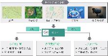
Fig. 1
Construction of multi-dimensional and diversified customized product system"
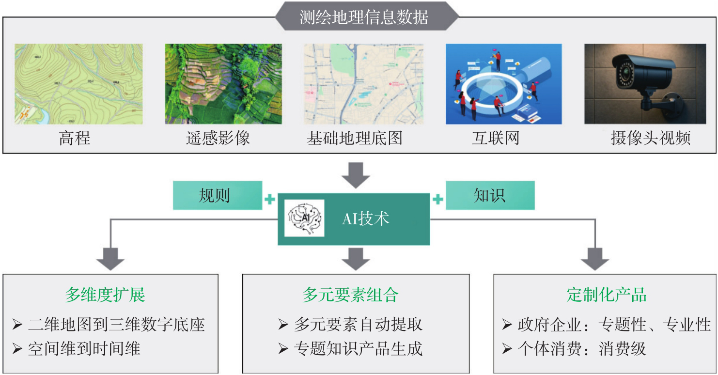
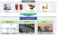
Fig. 2
Construction of personalized technology system oriented to application scenarios"
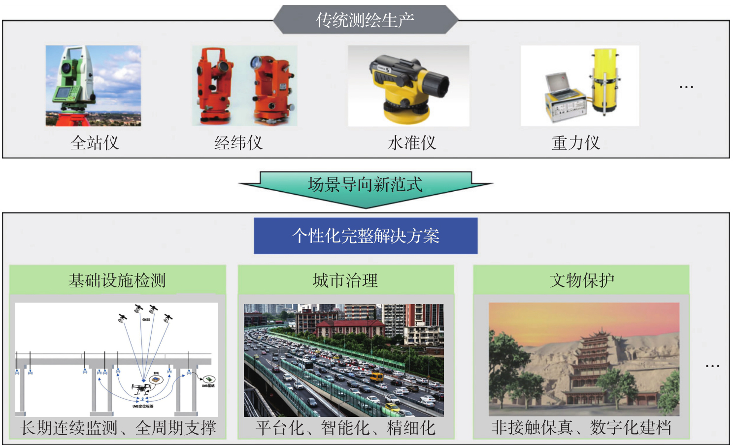
Fig. 3
New surveying and mapping public products"
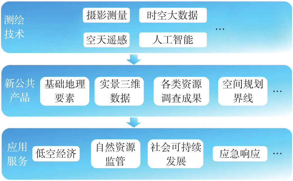
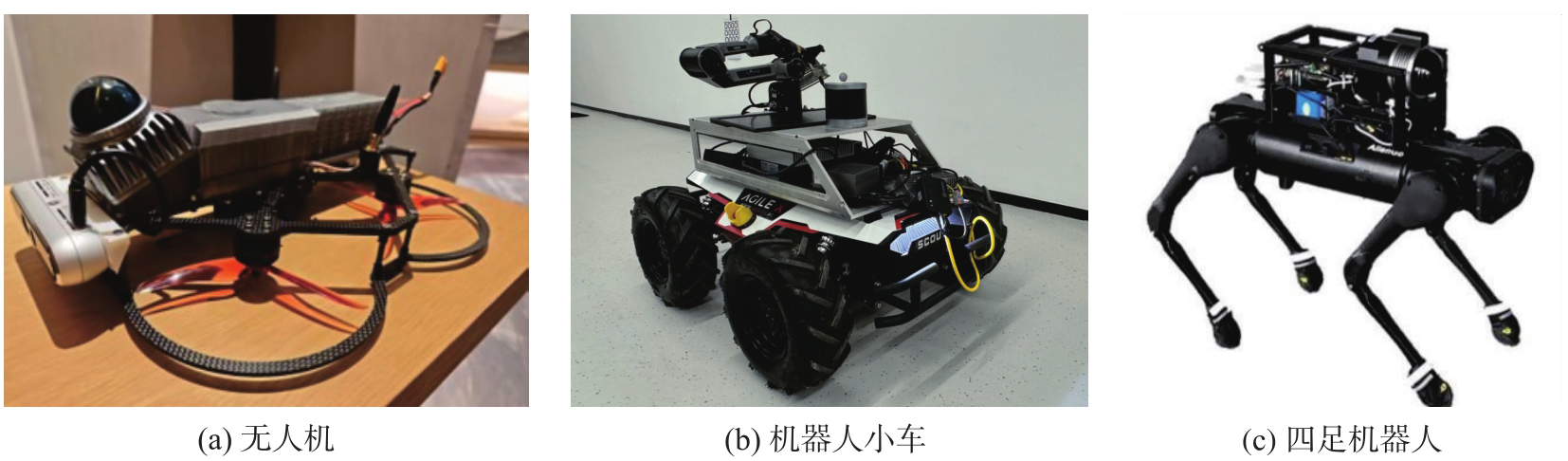
Fig. 4
Common unmanned autonomous surveying and mapping platforms"
| [1] |
李德仁, 王密, 申文斌, 等. 论人工智能时代的测绘学发展[J]. 测绘学报, 2025, 54(12): 2107-2115. DOI: .
doi: 10.11947/j.AGCS.2025.20250438 |
|
LI Deren, WANG Mi, SHEN Wenbin, et al. On the development of surveying and mapping in the era of artificial intelligence[J]. Acta Geodaetica et Cartographica Sinica, 2025, 54(12): 2107-2115. DOI: .
doi: 10.11947/j.AGCS.2025.20250438 |
|
| [2] |
李德仁, 徐小迪, 邵振峰. 论万物互联时代的地球空间信息学[J]. 测绘学报, 2022, 51(1): 1-8. DOI: .
doi: 10.11947/j.AGCS.2022.20210564 |
|
LI Deren, XU Xiaodi, SHAO Zhenfeng. On geospatial information science in the era of IoE[J]. Acta Geodaetica et Cartographica Sinica, 2022, 51(1): 1-8. DOI: .
doi: 10.11947/j.AGCS.2022.20210564 |
|
| [3] | TANG Yuzhi, YANG Chao, WU Haishan, et al. Tropical forest carbon offsets deliver partial gains amid persistent over-crediting[J]. Science, 2025, 390(6769): 182-187. |
| [4] |
XU Nan, ZHANG Zihao, XU Hao, et al. Multifaceted assessment of recent saltwater intrusion along China's coasts[J/OL]. Science Bulletin, 2026, 2: 021. DOI: .
doi: 10.1016/j.scib.2026.02.021 |
| [5] | YANG Chao, ZHANG Yinghui, CHEN Min, et al. Roof greening in major Chinese cities possibly afford a large potential carbon sink[J]. Science Bulletin, 2024, 69(20): 3216-3220. |
| [6] |
李清泉, 张德津, 汪驰升, 等. 动态精密工程测量技术及应用[J]. 测绘学报, 2021, 50(9): 1147-1158. DOI: .
doi: 10.11947/j.AGCS.2021.20210172 |
|
LI Qingquan, ZHANG Dejin, WANG Chisheng, et al. Technology and applications of dynamic and precise engineering surveying[J]. Acta Geodaetica et Cartographica Sinica, 2021, 50(9): 1147-1158. DOI: .
doi: 10.11947/j.AGCS.2021.20210172 |
|
| [7] | WANG Chisheng, CHANG Ling, WANG Xiangsheng, et al. Interferometric synthetic aperture radar statistical inference in deformation measurement and geophysical inversion: a review[J]. IEEE Geoscience and Remote Sensing Magazine, 2024, 12(1): 8-35. |
| [8] |
白正伟, 张勤, 黄观文, 等. “轻终端+行业云”的实时北斗滑坡监测技术[J]. 测绘学报, 2019, 48(11): 1424-1429. DOI: .
doi: 10.11947/j.AGCS.2019.20190167 |
|
BAI Zhengwei, ZHANG Qin, HUANG Guanwen, et al. Real-time BeiDou landslide monitoring technology of “light terminal plus industry cloud”[J]. Acta Geodaetica et Cartographica Sinica, 2019, 48(11): 1424-1429. DOI: .
doi: 10.11947/j.AGCS.2019.20190167 |
|
| [9] | 李清泉, 汪驰升, 熊思婷, 等. 从几何计算到特征提取的广义测量数据处理[J]. 武汉大学学报(信息科学版), 2022, 47(11): 1805-1814. |
| LI Qingquan, WANG Chisheng, XIONG Siting, et al. Generalized surveying data processing: from geometric parameters calculation to feature information extraction[J]. Geomatics and Information Science of Wuhan University, 2022, 47(11): 1805-1814. | |
| [10] | XIA Jizhe, YE Pei, PAN Longyan, et al. Mobile phone data show spatial and socioeconomic inequalities in hospital utilization[J/OL]. Nature Health, 2026: 1-10[2026-06-05]. https://doi.org/10.1038/s44360-026-00100-6. |
| [11] | SUN Xian, WANG Peijin, LU Wanxuan, et al. RingMo: a remote sensing foundation model with masked image modeling[J]. IEEE Transactions on Geoscience and Remote Sensing, 2023, 61: 5612822. |
| [12] | 张良培, 张乐飞, 袁强强. 遥感大模型:进展与前瞻[J]. 武汉大学学报(信息科学版), 2023, 48(10): 1574-1581. |
| ZHANG Liangpei, ZHANG Lefei, YUAN Qiangqiang. Large remote sensing model: progress and prospects[J]. Geomatics and Information Science of Wuhan University, 2023, 48(10): 1574-1581. | |
| [13] | WU Kang, ZHANG Yingying, RU Lixiang, et al. A semantic-enhanced multi-modal remote sensing foundation model for Earth observation[J]. Nature Machine Intelligence, 2025, 7(8): 1235-1249. |
| [14] |
龚健雅, 许越, 胡翔云, 等. 遥感影像智能解译样本库现状与研究[J]. 测绘学报, 2021, 50(8): 1013-1022. DOI: .
doi: 10.11947/j.AGCS.2021.20210085 |
|
GONG Jianya, XU Yue, HU Xiangyun, et al. Status analysis and research of sample database for intelligent interpretation of remote sensing image[J]. Acta Geodaetica et Cartographica Sinica, 2021, 50(8): 1013-1022. DOI: .
doi: 10.11947/j.AGCS.2021.20210085 |
|
| [15] |
史文中, 张敏. 人工智能用于遥感目标可靠性识别:总体框架设计、现状分析及展望[J]. 测绘学报, 2021, 50(8): 1049-1058. DOI: .
doi: 10.11947/j.AGCS.2021.20210095 |
|
SHI Wenzhong, ZHANG Min. Artificial intelligence for reliable object recognition from remotely sensed data: overall framework design, review and prospect[J]. Acta Geodaetica et Cartographica Sinica, 2021, 50(8): 1049-1058. DOI: .
doi: 10.11947/j.AGCS.2021.20210095 |
|
| [16] | ZHANG Yifan, WEI Cheng, HE Zhengting, et al. GeoGPT: an assistant for understanding and processing geospatial tasks[J]. International Journal of Applied Earth Observation and Geoinformation, 2024, 131: 103976. |
| [17] |
杨必胜, 董震. 点云智能研究进展与趋势[J]. 测绘学报, 2019, 48(12): 1575-1585. DOI: .
doi: 10.11947/j.AGCS.2019.20190465 |
|
YANG Bisheng, DONG Zhen. Progress and perspective of point cloud intelligence[J]. Acta Geodaetica et Cartographica Sinica, 2019, 48(12): 1575-1585. DOI: .
doi: 10.11947/j.AGCS.2019.20190465 |
|
| [18] | 李德仁, 沈欣. 我国天基信息实时智能服务系统发展战略研究[J]. 中国工程科学, 2020, 22(2): 138-143. |
| LI Deren, SHEN Xin. Research on the development strategy of RealTime and intelligent space-based information service system in China[J]. Strategic Study of CAE, 2020, 22(2): 138-143. | |
| [19] |
张永军, 张祖勋, 龚健雅. 天空地多源遥感数据的广义摄影测量学[J]. 测绘学报, 2021, 50(1): 1-11. DOI: .
doi: 10.11947/j.AGCS.2021.20200245 |
|
ZHANG Yongjun, ZHANG Zuxun, GONG Jianya. Generalized photogrammetry of spaceborne, airborne and terrestrial multi-source remote sensing datasets[J]. Acta Geodaetica et Cartographica Sinica, 2021, 50(1): 1-11. DOI: .
doi: 10.11947/j.AGCS.2021.20200245 |
|
| [20] |
杨元喜. 地理空间数字孪生与时空智能[J]. 测绘学报, 2025, 54(2): 213-220. DOI: .
doi: 10.11947/j.AGCS.2025.20240515 |
|
YANG Yuanxi. Digital twin and spatio-temporal intelligence of geospatial information system[J]. Acta Geodaetica et Cartographica Sinica, 2025, 54(2): 213-220. DOI: .
doi: 10.11947/j.AGCS.2025.20240515 |
|
| [21] | 李清泉, 李德仁. 大数据GIS[J]. 武汉大学学报(信息科学版), 2014, 39(6): 641-644, 666. |
| LI Qingquan, LI Deren. Big data GIS[J]. Geomatics and Information Science of Wuhan University, 2014, 39(6): 641-644, 666. | |
| [22] | 朱建军, 宋迎春, 胡俊, 等. 测绘大数据时代数据处理理论面临的挑战与发展[J]. 武汉大学学报(信息科学版), 2021, 46(7): 1025-1031. |
| ZHU Jianjun, SONG Yingchun, HU Jun, et al. Challenges and development of data processing theory in the era of surveying and mapping big data[J]. Geomatics and Information Science of Wuhan University, 2021, 46(7): 1025-1031. | |
| [23] |
郭仁忠, 贺彪, 赵志刚, 等. 智慧城市逻辑架构与孪生平台技术需求[J]. 测绘学报, 2025, 54(5): 777-784. DOI: .
doi: 10.11947/j.AGCS.2025.20240001 |
|
GUO Renzhong, HE Biao, ZHAO Zhigang, et al. Smart city logical framework and digital-twin platform technical requirements[J]. Acta Geodaetica et Cartographica Sinica, 2025, 54(5): 777-784. DOI: .
doi: 10.11947/j.AGCS.2025.20240001 |
|
| [24] | 徐开明. 整合变化监测业务,构建“一测多用”自然资源系统测绘生产体系[M]//测绘地理信息研究报告(2025). 北京: 社会科学文献出版社, 2025. |
| XU Kaiming. Integrate change monitoring services and build a “One Survey for Multiple Uses” surveying and mapping production system in natural resources system[M]//Research report on surveying, mapping and geographic information (2025). Beijing: Social Sciences Academic Press (China), 2025. | |
| [25] | 陈军, 武昊, 刘万增. 自然资源“一张图”的技术内涵与发展方向[J]. 时空信息学报, 2026, 33(1): 1-12. |
| CHEN Jun, WU Hao, LIU Wanzeng. Technical connotation and research agenda of China's “One Map” for natural resources[J]. Journal of Spatio-Temporal Information, 2026, 33(1): 1-12. | |
| [26] | 刘春, 艾克然木·艾克拜尔, 沈雨清, 等. 时空智能驱动低空技术的测绘新质发展[J]. 测绘通报, 2026(4): 11-19. |
| LIU Chun, Akram Akbar, SHEN Yuqing, et al. Spatio-temporal intelligence-driven new-quality development of low-altitude surveying and mapping[J]. Bulletin of Surveying and Mapping, 2026(4): 11-19. |
| [1] | Wanzeng LIU, Jun CHEN, Wei ZHANG. On the technical logic of geographic information confidentiality [J]. Acta Geodaetica et Cartographica Sinica, 2026, 55(5): 826-837. |
| [2] | Xusheng ZHOU, Yongbin TAN, Zhonghai YU, Wei WANG, Qingyun XIAO. A complex building shape recognition method integrating vector structural features [J]. Acta Geodaetica et Cartographica Sinica, 2026, 55(5): 838-849. |
| [3] | Ya ZHANG. Research on function classification method for urban building by combining POI semantics and spatial morphological features [J]. Acta Geodaetica et Cartographica Sinica, 2026, 55(5): 948-948. |
| [4] | Mingguang WU, Ziming CHENG. Color generation method for green maps considering use contexts [J]. Acta Geodaetica et Cartographica Sinica, 2026, 55(3): 390-403. |
| [5] | Min YANG, Hongran MA, Bo KONG, Pengcheng LIU, Tinghua AI. A pre-trained model-based method for discriminating morphological patterns of vector-based coastlines [J]. Acta Geodaetica et Cartographica Sinica, 2026, 55(3): 404-414. |
| [6] | Wenhao YU, Ziyi ZENG, Yifan ZHANG, Haizhong QIAN. Road network grid pattern analysis using a pre-trained model fusing spatial and topological information [J]. Acta Geodaetica et Cartographica Sinica, 2026, 55(3): 415-424. |
| [7] | Xiaomin LU, Zhiyi ZHANG, Haowen YAN, Yi HE, Xiaoning SU. A recognition method for building group pattern integrating deep graph infomax and multilayer perceptron [J]. Acta Geodaetica et Cartographica Sinica, 2026, 55(3): 425-438. |
| [8] | Yongcan YU, Jianhu ZHAO, Bingmo LI, Ziyang HE. Class-incremental update method for target recognition models in sidescan sonar images [J]. Acta Geodaetica et Cartographica Sinica, 2026, 55(3): 502-514. |
| [9] | Xiaoqiang CHENG, Jiawei ZHAO, Pengcheng LIU. Spatial interaction visualization based on the distance-similarity metaphor [J]. Acta Geodaetica et Cartographica Sinica, 2026, 55(3): 536-547. |
| [10] | Zejiao WANG, Longgang XIANG, Meng WANG, Xingjuan WANG, Qing LIU. Hierarchical feature and diversified attention fusion network for collaborative extraction of road surface and centerline [J]. Acta Geodaetica et Cartographica Sinica, 2026, 55(3): 548-563. |
| [11] | Zhibang XU. Hierarchical boundary identification, pattern analysis and expansion simulation of physical cities [J]. Acta Geodaetica et Cartographica Sinica, 2026, 55(3): 566-566. |
| [12] | Yunbo RAN, Xue YANG, Wenhao ZHOU, Chengen WU, Baoding ZHOU, Luliang TANG, Qingquan LI. Pedestrian path planning driven by preference-enhanced adversarial deep reinforcement learning [J]. Acta Geodaetica et Cartographica Sinica, 2026, 55(2): 191-205. |
| [13] | Lizeng WANG, Shifen CHENG, Yitao YANG, Peixiao WANG, Feng LU. LGA-EL: a spatio-temporal adaptive ensemble method with local-global awareness for traffic prediction [J]. Acta Geodaetica et Cartographica Sinica, 2026, 55(2): 206-221. |
| [14] | Shaohua WANG, Haojian LIANG, Cheng SU, Dachuan XU, Liang ZHOU, Kun QIN. Advances and prospects in urban facility allocation optimization through coupling spatio-temporal big data and artificial intelligence [J]. Acta Geodaetica et Cartographica Sinica, 2026, 55(2): 222-235. |
| [15] | Xiao FU, Sirui ZHU, Xudong LI, Guonian LÜ. An optimization method for the layout of urban vertiports in long-distance commuting scenarios [J]. Acta Geodaetica et Cartographica Sinica, 2026, 55(2): 236-248. |
| Viewed | ||||||
|
Full text |
|
|||||
|
Abstract |
|
|||||
