

Acta Geodaetica et Cartographica Sinica ›› 2024, Vol. 53 ›› Issue (4): 620-628.doi: 10.11947/j.AGCS.2024.20220580
• Geodesy and Navigation • Previous Articles Next Articles
Lintao LIU1( ), Jiangang HE1, Jiangning XU2, Leijun LIU1, Jinyao GAO3, Zhongmiao SUN4, Taiqi WU5, Xinghui LIANG1, Ming HU1, Junjian LANG1, Hongyang HE2
Received:2022-10-12
Revised:2024-01-16
Published:2024-05-13
About author:LIU Lintao (1967—), male, PhD, researcher, majors in time-frequency analysis, marine gravimeters and underwater navigation applications. E-mail: llt@apm.ac.cn
Supported by:CLC Number:
Lintao LIU, Jiangang HE, Jiangning XU, Leijun LIU, Jinyao GAO, Zhongmiao SUN, Taiqi WU, Xinghui LIANG, Ming HU, Junjian LANG, Hongyang HE. Development and practice of CHZ-Ⅱ marine gravimeter[J]. Acta Geodaetica et Cartographica Sinica, 2024, 53(4): 620-628.

Fig. 1
Zero length spring vertical suspension structure"
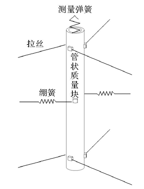
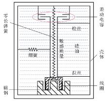
Fig. 2
Silicone oil damping"
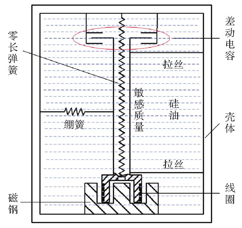

Fig. 3
The capacitance displacement measurement system"
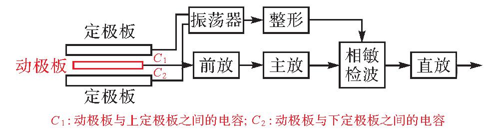

Fig. 4
Framework of force balance feedback system"
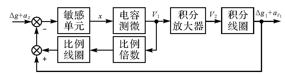
Fig. 5
Constant temperature structure of CHZ-Ⅱ gravimeter"
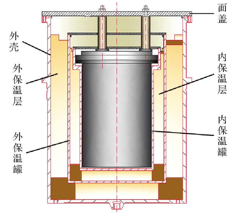
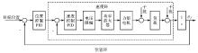
Fig. 6
Structure of composite control system"
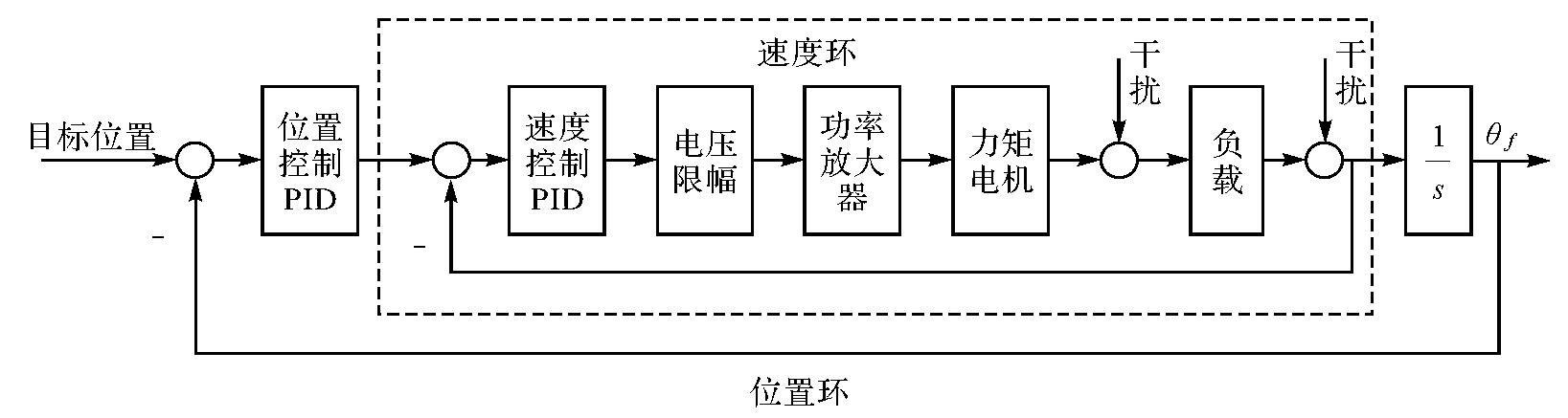
Fig. 7
Laboratory static test of CHZ-Ⅱ gravimeter"

Fig. 8
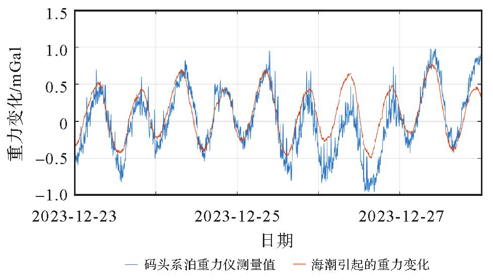
Wharf mooring test of CHZ-Ⅱ gravimeter"
Tab. 1
The results of previous marine tests of CHZ-Ⅱ gravimeter"
| 载体 | 测量时间 |
|---|---|
| 向阳红10 | 2015-04-28—2015-05-05 |
| 浙嘉渔辅00001 | 2016-06-25—2016-06-28 |
| 邓稼先号 | 2016-08-22—2016-09-26 |
| 科学号 | 2017-04-02—2017-06-09 |
| 南测429 | 2018-05-05—2018-07-07 |
| 向阳红06 | 2018-05-28—2018-06-25 |
| 向阳红10 | 2018-09-29—2018-11-27 |
| 大洋号 | 2019-08-23—2020-11-02 |
| 嘉庚号 | 2022-04-09—2022-06-03 |
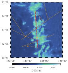
Fig. 9
The survey line for DaYang"

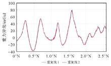
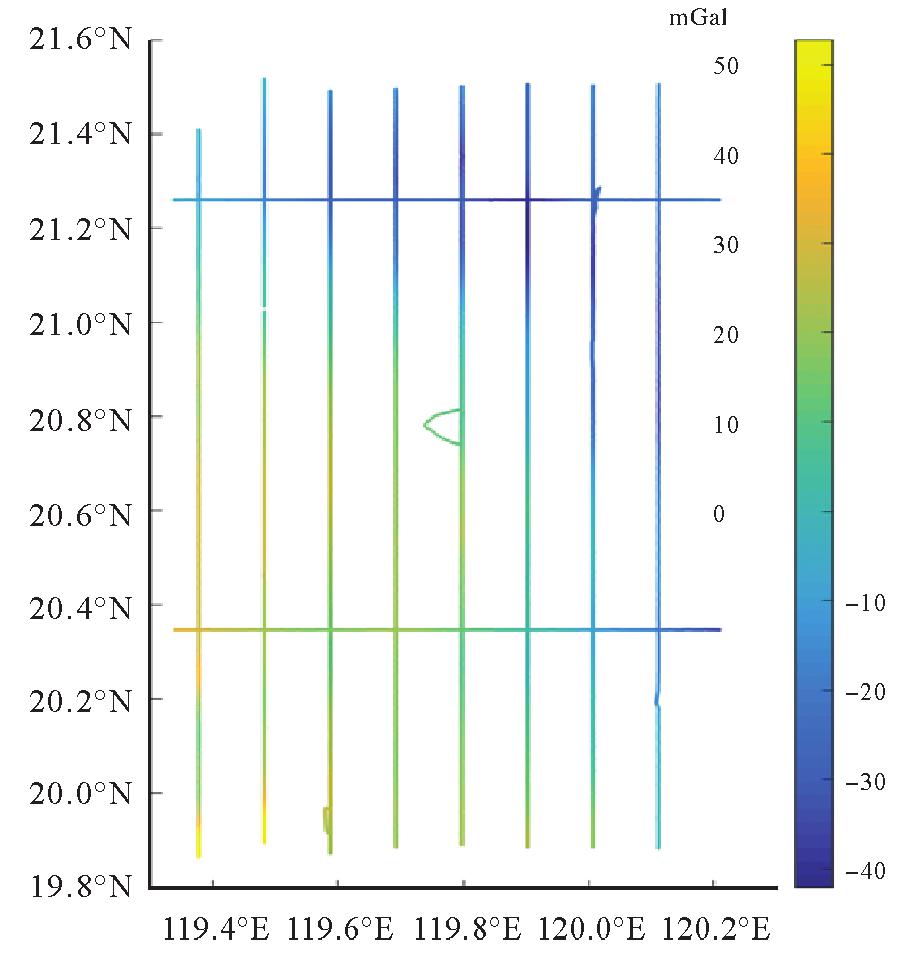
Fig. 10
The repeated line gravity anomaly of the CHZ-Ⅱ gravimeter on the DaYang"
Tab. 2
Statistics of repeat line discrepancy"
| 误差 | 最大值 | 最小值 | 平均值 | 中误差 |
|---|---|---|---|---|
| 平差前 | 1.57 | -1.61 | -0.01 | 0.58 |
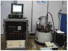
Fig. 11
CHZ-Ⅱ marine gravimeter on ship JiaGeng"

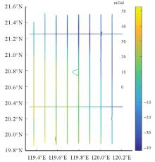
Fig. 12
Grid and crossover points measurement results of CHZ-Ⅱ marine gravimeter"
Tab. 3
Statistics of crossover points discrepancy"
| 误差 | 最大值 | 最小值 | 平均值 | 中误差 |
|---|---|---|---|---|
| 平差前 | 1.31 | -1.57 | -0.34 | 0.68 |
| 平差后 | 0.13 | -0.12 | -0.00 | 0.07 |
| [1] | LACOSTE L J B. Measurement of gravity at sea and in the air[J]. Reviews of Geophysics, 1967, 5(4):477-526. |
| [2] | DEHLINGER P. Marine gravity[M]. New York: Elservier Scientific Publishing Company, 1978. |
| [3] | TORGE W. Gravimetry[M]. Berlin: Walter de Gruyter, 1989. |
| [4] | 黄谟涛, 翟国君, 管铮, 等.海洋重力场测定及其应用[M]. 北京: 测绘出版社, 2005. |
| HUANG Motao, ZHAI Guojun, GUAN Zheng, et al. Determination and application of marine gravity field [M].Beijing: Surveying and Mapping Press, 2005. | |
| [5] | 李建成, 陈俊勇, 宁津生, 等.地球重力场逼近理论与中国2000似大地水准面的确定[M].武汉: 武汉大学出版社, 2003. |
| LI Jiancheng, CHEN Junyong, NING Jinsheng, et al. Theory of the Earth's gravity field approximation and determination of China Quasi-geoid 2000[M]. Wuhan: Wuhan University Press, 2003. | |
| [6] | 孙中苗.航空重力测量理论、方法及应用研究[D].郑州: 信息工程大学, 2004. |
| SUN Zhongmiao. Theory, methods and applications of airborne graivmetry [D]. Zhengzhou: Information Engineering University, 2004. | |
| [7] | 欧阳永忠.海空重力测量数据处理关键技术研究[D].武汉: 武汉大学, 2013. |
| OUYANG Yongzhong. On key technologies of data processing for air-sea gravity surveys[D]. Wuhan: Wuhan University, 2013. | |
| [8] | 张善言, 李锡其, 梁础坚, 等. 新研制的CHZ海洋重力仪[J]. 测绘学报, 1987, 16(1):1-6. |
| ZHANG Shanyan, LI Xiqi, LIANG Chujian, et al. Newly developed CHZ sea-gravimeter[J]. Acta Geodaetica et Cartographic Sinica, 1987, 16(1):1-6. | |
| [9] | 宗杰.CHZ重力仪在动态重力测量中的非线性问题[J].测绘学报, 1987, 16(1):7-15. |
| ZONG Jie.Nonlinear problem of CHZ gravimeter in dynamic gravity measurement[J]. Acta Geodaetica et Cartographica Sinica, 1987, 16(1):7-15. | |
| [10] | 刘若曾.CHZ海洋重力仪的室内外及海上试验[J].测量与地球物理集刊, 1988(9):87-93. |
| LIU Ruozeng. The test of CHZ sea gravimeter in laboratory and at sea[J].Acta Geodaetica et Geophysica, 1988(9):87-93. | |
| [11] | 张善言.CHZ海洋重力仪的若干特点[J].测量与地球物理集刊, 1991(12):93-102. |
| ZHANG Shanyan. Several distinguishing features of the CHZ sea gravimeter[J].Acta Geodaetica et Geophysica, 1991(12):93-102. | |
| [12] | 刘敏, 黄谟涛, 欧阳永忠, 等. 海空重力测量及应用技术研究进展与展望(二):传感器与测量规划设计技术[J]. 海洋测绘, 2017, 37(3):1-11. |
| LIU Min, HUANG Motao, OUYANG Yongzhong, et al. Development and prospect of air-sea gravity survey and its applications, part Ⅱ: sensor, plan and design of survey[J]. Hydrographic Surveying and Charting, 2017, 37(3):1-11. | |
| [13] | 吴美平, 蔡劭琨, 于瑞航, 等. 捷联式重力测量技术研究进展[J]. 导航与控制, 2020, 19(S1):161-169. |
| WU Meiping, CAI Shaokun, YU Ruihang, et al. Research progress on strapdown gravimetry technology[J]. Navigation and Control, 2020, 19(S1):161-169. | |
| [14] | 袁园, 高金耀, 高巍. 基于惯性稳定平台的ZL11-1A海洋重力仪性能评估[J]. 海洋测绘, 2021, 41(1):22-26. |
| YUAN Yuan, GAO Jinyao, GAO Wei. A new shipborne gravimeter ZL11-1A based on inertial stabilization platform and its performance evaluation[J]. Hydrographic Surveying and Charting, 2021, 41(1):22-26. | |
| [15] | 修睿, 郭刚, 薛正兵, 等. 海空重力仪的技术现状及新应用[J]. 导航与控制, 2019, 18(1):35-43. |
| XIU Rui, GUO Gang, XUE Zhengbing, et al. Technicalcurrent situation and new application of marine/aviation gravimeter[J]. Navigation and Control, 2019, 18(1):35-43. | |
| [16] | 胡平华, 黄鹤, 赵明, 等. GIPS-1AM高精度惯性稳定平台式海空重力仪的设计与试验[J]. 导航定位与授时, 2015, 2(3):16-22. |
| HU Pinghua, HUANG He, ZHAO Ming, et al. Design and testing of GIPS-1AM Airborne/marine gravimeter based on high precision inertial stabilized platform[J]. Navigation Positioning and Timing, 2015, 2(3):16-22. | |
| [17] | 刘雷钧, 何建刚, 涂海波, 等. 载体垂向扰动对轴对称型金属弹簧海洋重力仪的影响[J]. 地球科学进展, 2021, 36(5):520-527. |
| LIU Leijun, HE Jiangang, TU Haibo, et al. Influence of vertical disturbance from the carrier on axisymmetric metal spring marine gravimeter[J]. Advances in Earth Science, 2021, 36(5):520-527. | |
| [18] | 涂海波, 胡明, 董琴琴, 等. CHZ型重力仪重力测量伺服回路的分频段控制方案[J]. 导航与控制, 2015, 14(2):41-45. |
| TU Haibo, HU Ming, DONG Qinqin, et al. Frequency-piecewise control scheme for the gravity measurement servo loop of the CHZ gravimeter[J]. Navigation and Control, 2015, 14(2):41-45. | |
| [19] | 梁础坚. CHZ海洋重力仪伺服系统[J]. 测量与地球物理集刊, 1988(9):95-105. |
| LIANG Chujian. CHZ sea gravimeter servo system[J]. Acta Geodaetica et Geophysica, 1988(9):95-105. | |
| [20] | 宗杰. CHZ海洋重力仪的恒温与温补[J]. 测量与地球物理集刊, 1988(9):107-111. |
| ZONG Jie. The constant temperature and temperature compensation of CHZ sea gravimeter[J]. Acta Geodaetica et Geophysica, 1988(9):107-111. | |
| [21] | 何泓洋.高精度光纤陀螺稳定平台控制系统研究[D].武汉: 海军工程大学, 2013. |
| HE Hongyang. Research on control system of high precision fog stabilized platform [D]. Wuhan: Naval University of Engineering, 2013. | |
| [22] | 许江宁, 何泓洋, 吴苗, 等. 重力测量平台自主式姿态确定原理[M]. 北京: 科学出版社, 2021. |
| XU Jiangning, HE Hongyang, WU Miao, et al. Principle of autonomous attitude determination of gravity measurement platform[M]. Beijing: Science Press, 2021. | |
| [23] | 中华人民共和国国家质量监督检疫总局. 海洋调查规范 第8部分:海洋地质地球物理调查:GB/T 12763.8—2007[S]. 北京: 中国标准出版社, 2008. |
| General Administation of Quality Supervision, Inspection and Quarantine of the People's Republic of China, Specifications for oceanographic survey part 8: marine geology and geophysics survey: GB/T 12763.8—2007[S]. Beijing: Standards Press of China, 2008. | |
| [24] | 黄谟涛, 欧阳永忠, 翟国君, 等. 海面与航空重力测量重复测线精度评估公式注记[J]. 武汉大学学报(信息科学版), 2013, 38(10):1175-1177. |
| HUANG Motao, OUYANG Yongzhong, ZHAI Guojun, et al. Comment on the formulas of accuracy evaluation for multi-line overlapping measurements in ship-borne and airborne gravity survey[J]. Geomatics and Information Science of Wuhan University, 2013, 38(10):1175-1177. | |
| [25] | TU Haibo, HE Jiangang, HU Ming, et al. Modeling of errors resulting from vehicle motions for CHZ-II mobile gravimeter and its performance verification during marine surveys[J]. Applied Geophysics, 2021, 20:592-599. |
| [26] | YUAN Yuan, GAO Jinyao, WU Zhaocai, et al. Performance estimate of some prototypes of inertial platform and strapdown marine gravimeters[J]. Earth, Planets and Space, 2020, 72(1):11091-11099. |
| [1] | Hongmei WANG, Lihua WANG, Benhua TAN, Xiaoyi JIANG, Lili SONG, Weiwei SUN. SAR high-precision inversion of sea surface current over offshore China [J]. Acta Geodaetica et Cartographica Sinica, 2026, 55(4): 588-603. |
| [2] | Yi GAO, Xin LIU, Daocheng YU, Shaoshuai YA, Shaofeng BIAN, Heping SUN, Jinyun GUO. An automated seamount detection method integrating vertical gravity gradient anomaly and seafloor topographic models [J]. Acta Geodaetica et Cartographica Sinica, 2026, 55(4): 647-657. |
| [3] | Siyuan BAI, Hongzhou CHAI, Qing WU, Gen LI, Yuhao YE, Honglei MA. Buoys-aided integrated navigation method for UUV under ice with sea ice drift compensation [J]. Acta Geodaetica et Cartographica Sinica, 2026, 55(4): 698-707. |
| [4] | Jiachao BIAN, Shuqiang XUE, Shuang ZHAO, Jixing ZHU, Jinlai GAO, Baojin LI. Multi-window joint robust estimation for marine acoustic navigation [J]. Acta Geodaetica et Cartographica Sinica, 2026, 55(3): 515-524. |
| [5] | Shuqiang XUE, Jinlai GAO, Shuang ZHAO, Baojin LI, Yunhao FAN, Bingqian LIU. A static acoustic delay compensation positioning model [J]. Acta Geodaetica et Cartographica Sinica, 2026, 55(2): 275-286. |
| [6] | Qiqian SUN, Shuaidong JIA, Zhicheng LIANG, Xianpeng LIU, Haoshi SONG. A method for constructing digital depth model of strait passage considering crowdsourced bathymetric data characteristics [J]. Acta Geodaetica et Cartographica Sinica, 2026, 55(1): 90-100. |
| [7] | Gen LI, Hongzhou CHAI, Kaidi JIN, Zhao ZHAN. Underwater terrain matching method based on robust particle filter [J]. Acta Geodaetica et Cartographica Sinica, 2025, 54(10): 1841-1851. |
| [8] | Shaobo LI. Research on sub-bottom buried target detection and acoustic classification of sediment [J]. Acta Geodaetica et Cartographica Sinica, 2025, 54(10): 1911-1911. |
| [9] | Dongdong PU, Hongzhou CHAI, Yongzhong OUYANG, Chao DONG. Hierarchical encryption matching algorithm for adjacent strip splicing in airborne LiDAR bathymetry [J]. Acta Geodaetica et Cartographica Sinica, 2025, 54(8): 1439-1451. |
| [10] | Yijie ZHAO, Junting WANG, Tianhe XU, Jianxu SHU, Yangfan LIU. Correction method for time-varying sound speed errors in underwater geodetic datum positioning [J]. Acta Geodaetica et Cartographica Sinica, 2025, 54(8): 1452-1463. |
| [11] | Xiaodong CHEN, Meng YANG, Yuan YUAN, Wei FENG, Jinway HWANG, Min ZHONG. Evaluation of the accuracy and spatial resolution of SWOT_02 marine gravity model in China's offshore regions [J]. Acta Geodaetica et Cartographica Sinica, 2025, 54(6): 1031-1041. |
| [12] | Dianpeng SU, Bin WANG, Xiaozheng MAI, Huang MENG, Chao QI, Fanlin YANG. Calibration of placement angle errors of airborne bathymetric LiDAR without field control [J]. Acta Geodaetica et Cartographica Sinica, 2025, 54(6): 1042-1053. |
| [13] | Wenzhou SUN, Anmin ZENG, Zhengming QIAO. Influence of draft depth error of acoustic ray tracing on underwater positioning [J]. Acta Geodaetica et Cartographica Sinica, 2025, 54(5): 831-839. |
| [14] | Haolong GAO, Shaobo LI, Jianhu ZHAO. Multipath negative outlier removal method for coastal LiDAR point clouds based on mirror structure and intensity feature constraints [J]. Acta Geodaetica et Cartographica Sinica, 2025, 54(5): 840-852. |
| [15] | Sai MEI. Research and application of key technologies for deep-sea cold seep detection [J]. Acta Geodaetica et Cartographica Sinica, 2025, 54(3): 584-584. |
| Viewed | ||||||
|
Full text |
|
|||||
|
Abstract |
|
|||||