

Acta Geodaetica et Cartographica Sinica ›› 2024, Vol. 53 ›› Issue (10): 1920-1929.doi: 10.11947/j.AGCS.2024.20230540.
• Major Satellite Surveying and Mapping Project “LuTan-1” • Previous Articles Next Articles
Xinyou SONG1,( ), Lei ZHANG1(), Tao LI2, Baocheng LEI1, Ruiqing SONG1
Received:2023-11-22
Online:2024-11-26
Published:2024-11-26
Contact:
Lei ZHANG
E-mail:xinyou@tongji.edu.cn;lslzhang@tongji.edu.cn
About author:SONG Xingyou (1996—), male, PhD candidate, majors in InSAR data processing and its application in deformation monitoring. E-mail: xinyou@tongji.edu.cn
Supported by:CLC Number:
Xinyou SONG, Lei ZHANG, Tao LI, Baocheng LEI, Ruiqing SONG. Baseline refinement and DEM accuracy analysis during the in-orbit test phase of LT-1 SAR[J]. Acta Geodaetica et Cartographica Sinica, 2024, 53(10): 1920-1929.
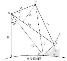
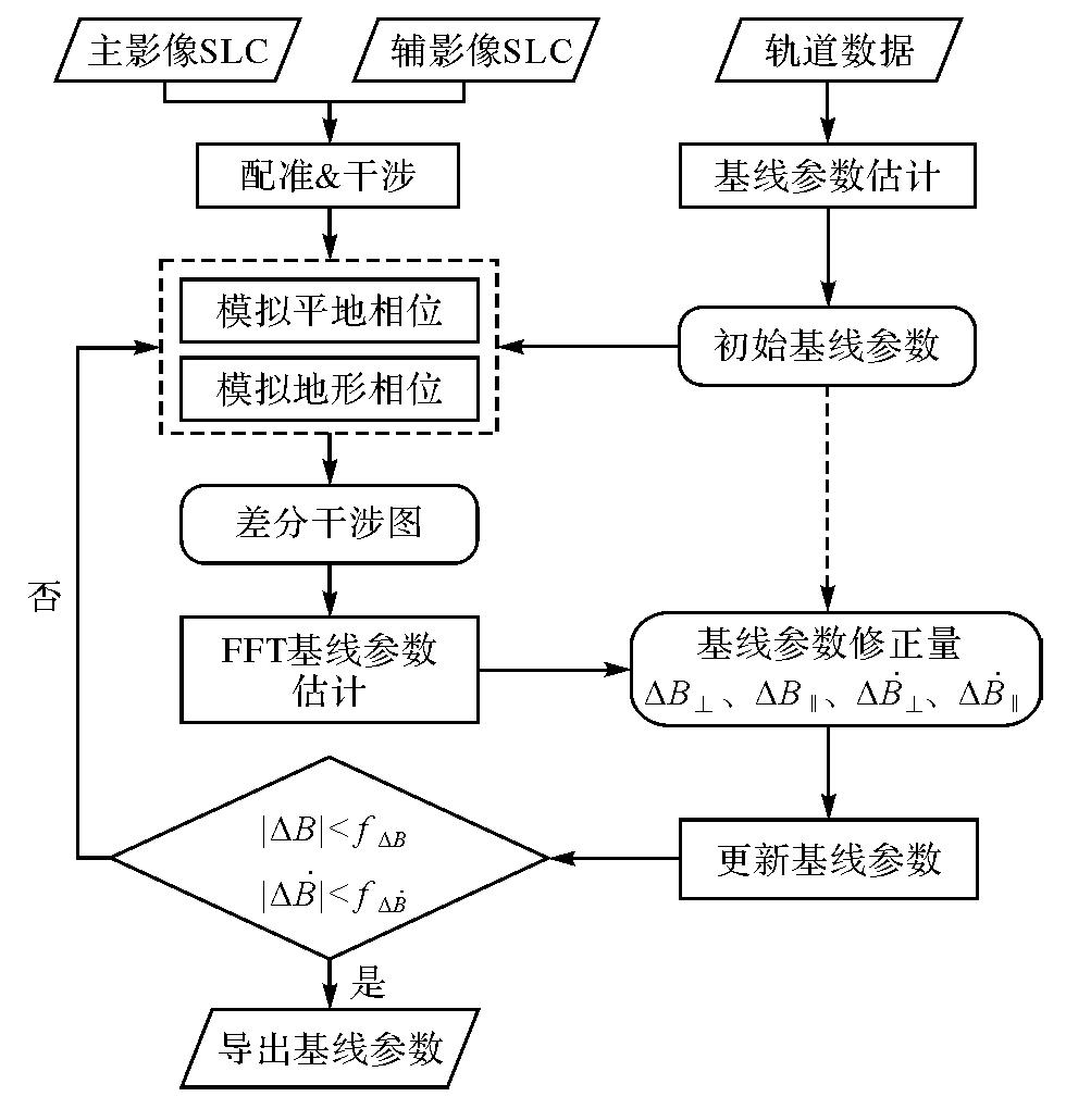
Fig.1
InSAR interferometric geometric model"
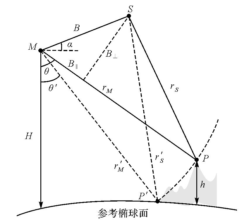
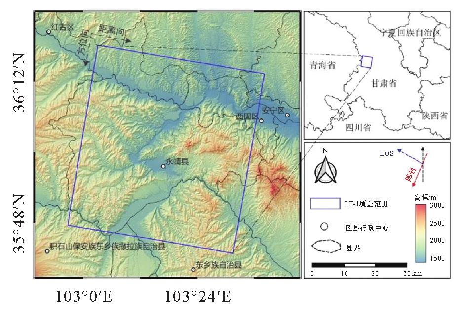
Fig.2
Study area and data coverages"
Tab.1
Interference pairs information"
| 日期 | 轨道 | 主影像卫星 | 辅影像卫星 | 时间基线 | 空间垂直基线/m | 入射角/(°) |
|---|---|---|---|---|---|---|
| 2022-09-21 | 降轨 | LT-1A | LT-1B | 0 | 1 801.773 5 | 41.8 |
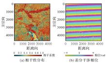
Fig.3
Coherence and differential interferograms"
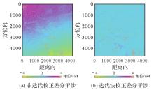
Fig.4
Comparison of differential interferograms before and after FFT iteration"

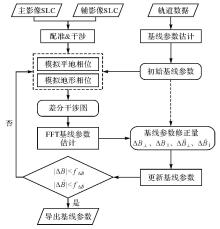
Fig.5
Flowchart of iterative FFT algorithm"
Tab.2
Iterative values of baseline parameters"
| 迭代次数 | ΔB‖/mm | ΔB⊥/mm | ΔB/mm |  /(mm/s) /(mm/s) |  /(mm/s) /(mm/s) |  /(mm/s) /(mm/s) |
|---|---|---|---|---|---|---|
| 1 | 6.27×10⁻³ | 268.78 | 268.78 | 168.34 | 4.71×10⁻⁴ | 168.34 |
| 2 | 2.86×10⁻³ | 129.88 | 129.88 | 32.68 | 9.15×10⁻⁵ | 32.68 |
| 3 | 1.81×10⁻³ | 37.05 | 37.05 | 0.28 | 7.92×10⁻⁷ | 0.28 |
| 4 | 1.29×10⁻³ | 6.03 | 6.03 | 0.25 | 6.86×10⁻⁷ | 0.25 |
| 5 | 8.31×10⁻⁴ | 1.90 | 1.90 | 0.21 | 5.99×10⁻⁷ | 0.21 |
| 6 | 7.68×10⁻⁴ | 0.97 | 0.97 | 0.18 | 5.26×10⁻⁷ | 0.18 |
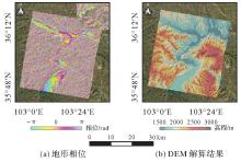
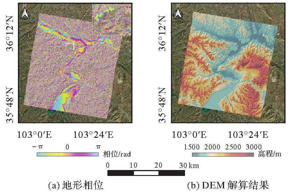
Fig.6
LT-1 topographic phase and DEM solution results"
Tab.3
Comparison of main parameters of DEM"
| 名称 | 观测平台 | 采集时间 | 参考基准 | 空间分辨率/m | 绝对精度/m | 技术手段 |
|---|---|---|---|---|---|---|
| SRTM | 航天飞机 | 2000 | WGS-84/EGM96 | 30/90 | <9 | InSAR |
| AW3D | ALOS-1 | 2006—2011 | WGS-84/EGM96 | 30/90 | 4.4 | 光学立体摄影测量 |
| COP DEM | TanDEM-X&TerraSAR-X | 2010—2015 | WGS-84/EGM2008 | 30/90 | 2.1 | InSAR |
| LT-1 DEM | LT-1A/B | 2022 | WGS-84/椭球面 | 12.5 | — | InSAR |
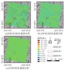
Fig.7
LT-1 DEM elevation differences comparison"
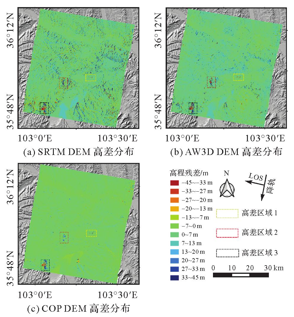
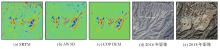
Fig.8
Area 1 elevation differences contrast and historical optical imagery"
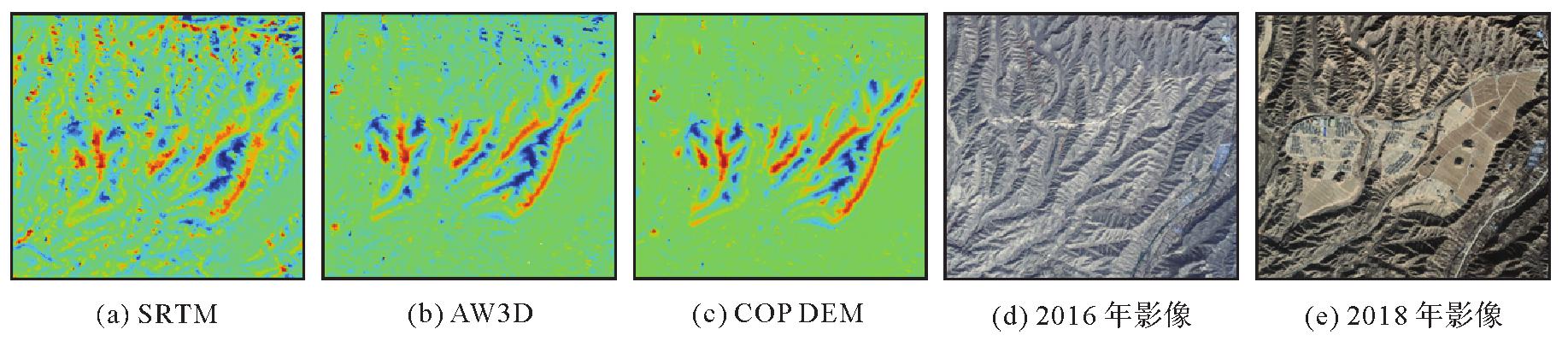
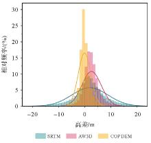
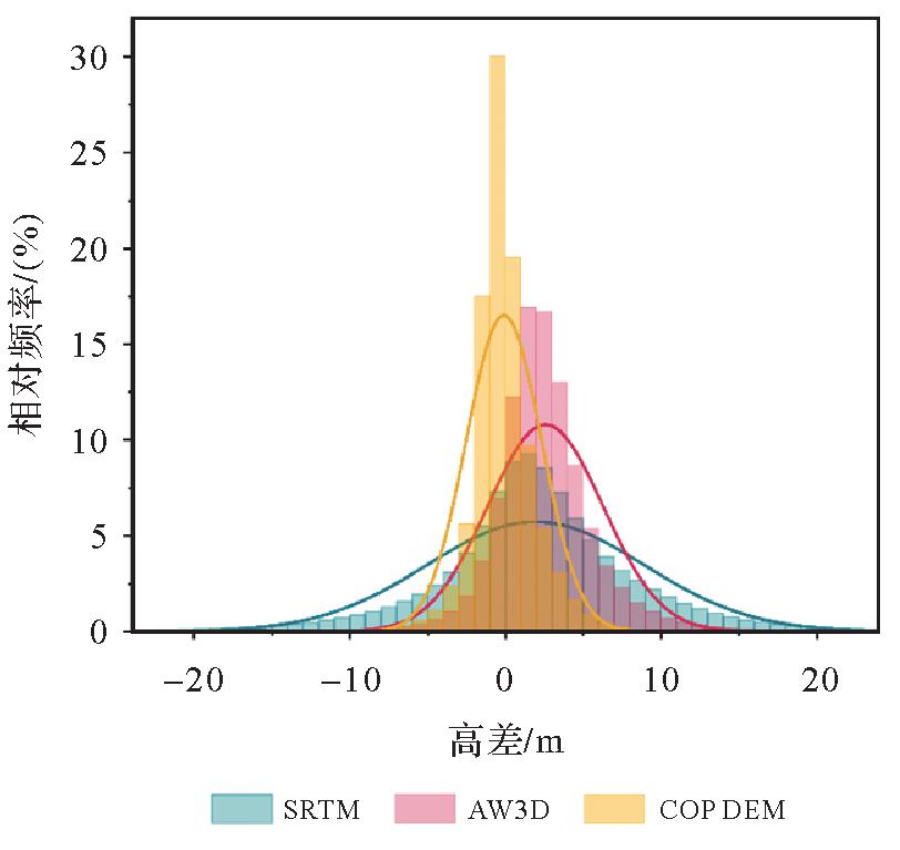
Fig.9
Statistical distribution of elevation differences"
| [1] |
李涛, 唐新明, 李世金, 等. L波段差分干涉SAR卫星基础形变产品分类[J]. 测绘学报, 2023, 52(5):769-779. DOI:.
doi: 10.11947/j.AGCS.2023.20220050 |
|
LI Tao, TANG Xinming, LI Shijin, et al. Classification of basic deformation products of L-band differential interfero-metric SAR satellite[J]. Acta Geodaetica et Cartographica Sinica, 2023, 52(5):769-779. DOI:.
doi: 10.11947/j.AGCS.2023.20220050 |
|
| [2] | HU Jun, ZHU Kang, FU Haiqiang, et al. Isolating orbital error from multitemporal InSAR derived tectonic deformation based on wavelet and independent component analysis[J]. IEEE Geoscience and Remote Sensing Letters, 2022, 19:4510705. |
| [3] | SHIRZAEI M, WALTER T R. Estimating the effect of satellite orbital error using wavelet-based robust regression applied to InSAR deformation data[J]. IEEE Transactions on Geoscience and Remote Sensing, 2011, 49(11):4600-4605. |
| [4] | FATTAHI H, AMELUNG F. InSAR uncertainty due to orbital errors[J]. Geophysical Journal International, 2014, 199(1):549-560. |
| [5] | ZHANG Lei, DING Xiaoli, LU Zhong, et al. A novel multitemporal InSAR model for joint estimation of deformation rates and orbital errors[J]. IEEE Transactions on Geoscience and Remote Sensing, 2014, 52(6):3529-3540. |
| [6] | WRIGHT T J, PARSONS B, ENGLAND P C, et al. InSAR observations of low slip rates on the major faults of western Tibet[J]. Science, 2004, 305(5681):236-239. |
| [7] | DU Yanan, FU Haiqiang, LIU Lin, et al. Orbit error removal in InSAR/MTInSAR with a patch-based polynomial model[J]. International Journal of Applied Earth Observation and Geoinformation, 2021, 102:102438. |
| [8] | XU Bing, LI Zhiwei, WANG Qijie, et al. A refined strategy for removing composite errors of SAR interferogram[J]. IEEE Geoscience and Remote Sensing Letters, 2014, 11(1):143-147. |
| [9] | AMELUNG F, YUN S H, WALTER T R, et al. Stress control of deep rift intrusion at Mauna Loa volcano, Hawaii[J]. Science, 2007, 316(5827):1026-1030. |
| [10] | TIAN Xin, MALHOTRA R, XU Bing, et al. Modeling orbital error in InSAR interferogram using frequency and spatial domain based methods[J]. Remote Sensing, 2018, 10(4):508. |
| [11] | KOHLHASE A O, FEIGL K L, MASSONNET D. Applying differential InSAR to orbital dynamics: a new approach for estimating ERS trajectories[J]. Journal of Geodesy, 2003, 77(9):493-502. |
| [12] | BÄHR H, HANSSEN R. Network adjustment of orbit errors in SAR interferometry[J]. Journal of Geodesy, 2012, 86:1147-1164. |
| [13] | PEPE A, BERARDINO P, BONANO M, et al. SBAS-based satellite orbit correction for the generation of DInSAR time-series: application to RADARSAT-1 data[J]. IEEE Transactions on Geoscience and Remote Sensing, 2011, 49(12):5150-5165. |
| [14] | HANSSEN B R F. Radar interferometry: data interpretation and error analysis[M]. Dordrecht: Kluwer Academic, 2001. |
| [15] | LU Zhong, DZURISIN D. InSAR imaging of aleutian volcanoes[M]//InSAR Imaging of Aleutian Volcanoes. Berlin, Heidelberg: Springer, 2014: 87-345. |
| [16] | BÄHR H. Orbital effects in spaceborne synthetic aperture radar interferometry[D]. Karlsruhe: Karlsruhe Institute of Technology. 2013. |
| [17] | SINGH K, STUSSI N, KEONG K L, et al. Baseline estimation in interferometric SAR[C]//Proceedings of 1997 IEEE International Geoscience and Remote Sensing Symposium Proceedings. Singapore: IEEE, 1997: 454-456. |
| [18] | 唐晓青, 向茂生, 吴一戎. 一种改进的基于干涉相位的基线估计方法[J]. 电子与信息学报, 2008, 30(12):2795-2799. |
| TANG Xiaoqing, XIANG Maosheng, WU Yirong. An improved baseline estimation approach based on the interferometric phases[J]. Journal of Electronics & Information Technology, 2008, 30(12):2795-2799. | |
| [19] | 葛大庆, 戴可人, 郭兆成, 等. 重大地质灾害隐患早期识别中综合遥感应用的思考与建议[J]. 武汉大学学报(信息科学版), 2019, 44(7):949-956. |
| GE Daqing, DAI Keren, GUO Zhaocheng, et al. Early identification of serious geological hazards with integrated remote sensing technologies: thoughts and recommendations[J]. Geomatics and Information Science of Wuhan University, 2019, 44(7):949-956. | |
| [20] | TADONO T, NAGAI H, ISHIDA H, et al. Generation of the 30 m-mesh global digital surface model by ALOS prism[J]. The International Archives of the Photogrammetry, Remote Sensing and Spatial Information Sciences, 2016, XLI-B4:157-162. |
| [21] | SICA F, COZZOLINO D, ZHU Xiaoxiang, et al. InSAR-BM3D: a nonlocal filter for SAR interferometric phase restoration[J]. IEEE Transactions on Geoscience and Remote Sensing, 2018, 56(6):3456-3467. |
| [22] | PEPE A, LANARI R. On the extension of the minimum cost flow algorithm for phase unwrapping of multitemporal differential SAR interferograms[J]. IEEE Transactions on Geoscience and Remote Sensing, 2006, 44(9):2374-2383. |
| [23] | 张磊, 伍吉仓, 陈艳玲. InSAR高程模型及其精度分析[J]. 武汉大学学报(信息科学版), 2007, 32(2):108-111, 119. |
| ZHANG Lei, WU Jicang, CHEN Yanling. An elevation model of InSAR and its accuracy analysis[J]. Geomatics and Information Science of Wuhan University, 2007, 32(2):108-111, 119. | |
| [24] | ZHANG Wenting, ZHU Wu, TIAN Xudong, et al. Improved DEM reconstruction method based on multibaseline InSAR[J]. IEEE Geoscience and Remote Sensing Letters, 2022, 19:4011505. |
| [25] | ZHANG Lei, JIA Hongguo, LU Zhong, et al. Minimizing height effects in MTInSAR for deformation detection over built areas[J]. IEEE Transactions on Geoscience and Remote Sensing, 2019, 57(11):9167-9176. |
| [26] | RODRÍGUEZ E, MORRIS C S, BELZ J E, et al. An assessment of the SRTM topographic products, Technical Report JPL D-31639[P]. Pasadena: JPL, 2005. |
| [27] | MARESOVÁ J, GDULOVÁ K, PRACNÁ P, et al. Applicability of data acquisition characteristics to the identification of local artefacts in global digital elevation models: comparison of the Copernicus and TanDEM-X DEMs[J]. Remote Sensing, 2021, 13(19):3931. |
| [28] | Copernicus DEM product handbook[EB/OL][2023-11-20]. http://spacedata.copernicus.eu/documents/20123/121239/GEO1988-CopernicusDEM-SPE-002_ProductHandbook_24.0.pdf. |
| [29] | 李鹏, 李振洪, 施闯, 等. 大地水准面高对InSAR大范围地壳形变监测的影响分析[J]. 地球物理学报, 2013, 56(6):1857-1867. |
| LI Peng, LI Zhenhong, SHI Chuang, et al. Impacts of geoid height on large-scale crustal deformation mapping with InSAR observations[J]. Chinese Journal of Geophysics, 2013, 56(6):1857-1867. |
| [1] | Zhong LU, Jinqi ZHAO, Yufen NIU, Liquan CHEN, Qianyou FAN, Jinzhao SI, Zixuan WANG, Yuan GAO, Shuai WANG, Feifei QU, Hongtao SHI, Shiyong YAN, Yun SHI, Zheng ZHAO. The NISAR mission: innovations in earth observation and applications in surface deformation monitoring [J]. Acta Geodaetica et Cartographica Sinica, 2026, 55(2): 261-274. |
| [2] | Peng LI, Jianbo BAI, Zhenhong LI, Houjie WANG. Wide area coastal subsidence monitoring and driver analysis with multi tracks of TS-InSAR—a case study of Shandong province [J]. Acta Geodaetica et Cartographica Sinica, 2025, 54(7): 1178-1191. |
| [3] | Kefu WU, Haiqiang FU, Jianjun ZHU, Qijin HAN, Aichun WANG, Mingxia ZHANG, Zhiwei LI. LT-1 InSAR block adjustment considering the impact of penetration depth in forest areas [J]. Acta Geodaetica et Cartographica Sinica, 2025, 54(6): 1009-1020. |
| [4] | Zhaofeng DU, Guopeng LI, Zhanke LIU, Xiaming SHANG, Shengjun KANG, Xiaoqiang WANG. Comprehensive analysis of multiple monitoring methods in main subsidence areas [J]. Acta Geodaetica et Cartographica Sinica, 2025, 54(3): 481-492. |
| [5] | Hailu CHEN, Yunzhong SHEN. GNSS-assisted InSAR tropospheric delay correction model incorporating vertical stratification and turbulent components [J]. Acta Geodaetica et Cartographica Sinica, 2025, 54(10): 1786-1797. |
| [6] | Liming JIANG, Yi SHAO, Zhiwei ZHOU, Peifeng MA, Teng WANG. A review of intelligent InSAR data processing: recent advancements, challenges and prospects [J]. Acta Geodaetica et Cartographica Sinica, 2024, 53(6): 1037-1056. |
| [7] | Canghai ZHOU, Zhen TIAN, Zhen SHI, Hayinaer TUOKAN. The characteristic of the Yadong-Gulu faults motion constraints by InSAR timeseries and GNSS observations [J]. Acta Geodaetica et Cartographica Sinica, 2024, 53(5): 933-945. |
| [8] | Jun ZHU, Wei PENG, Haiqiang FU, Man OU, Shancheng LEI, Shiping ZHANG. Large-scale TanDEM-X InSAR sub-canopy topography inversion under insufficient observation information [J]. Acta Geodaetica et Cartographica Sinica, 2024, 53(5): 959-966. |
| [9] | Yandong GAO, Yikun JIA, Shijin LI, Yu CHEN, Huaizhan LI, Nanshan ZHENG, Shubi ZHANG. The improved max-flow/min-cut weight algorithm for InSAR phase unwrapping [J]. Acta Geodaetica et Cartographica Sinica, 2024, 53(4): 644-652. |
| [10] | HE Yi, YANG Wang, ZHU Qing. An InSAR phase unwrapping method based on R2AU-Net [J]. Acta Geodaetica et Cartographica Sinica, 2024, 53(3): 435-449. |
| [11] | WANG Yuan, XU Huaping, LI Chunsheng, ZENG Guobing, LIU Aifang, GE Shiqi. Analysis of interferometric mapping accuracy for spaceborne distributed SAR dual-frequency alternative bistatic mode [J]. Acta Geodaetica et Cartographica Sinica, 2024, 53(3): 463-472. |
| [12] | YUE Jiawei, HUANG Qihuan, LIU Hui, MA Zhangfeng. A multi-baseline phase unwrapping method based on a discrete optimization framework [J]. Acta Geodaetica et Cartographica Sinica, 2024, 53(3): 473-481. |
| [13] | Xinming TANG, Tao LI, Xiang ZHANG, Xiaoqing ZHOU, Jing LU, Xuefei ZHANG. In-orbit application parameters test and analysis of L-band differential interferometric SAR satellite constellation [J]. Acta Geodaetica et Cartographica Sinica, 2024, 53(10): 1863-1872. |
| [14] | Mingliang TAO, Jieshuang LI, Yanyang LIU, Junli CHEN, Yifei LIU, Jiawang LI. Mitigation of radio frequency interference signatures and image quality enhancement for L-band differential interferometric SAR satellite images [J]. Acta Geodaetica et Cartographica Sinica, 2024, 53(10): 1896-1909. |
| [15] | Yandong GAO, Nanshan ZHENG, Yansuo ZHANG, Shijin LI, Huachao YANG, Hefang BIAN, Qiuzhao ZHANG, Shubi ZHANG, Yu TIAN. A phase unwrapping method based on phase quality fusion estimation and information filtering [J]. Acta Geodaetica et Cartographica Sinica, 2024, 53(10): 1910-1919. |
| Viewed | ||||||
|
Full text |
|
|||||
|
Abstract |
|
|||||