

Acta Geodaetica et Cartographica Sinica ›› 2025, Vol. 54 ›› Issue (9): 1697-1711.doi: 10.11947/j.AGCS.2025.20240385
• Cartography and Geoinformation • Previous Articles Next Articles
Fubing ZHANG1,2( ), Qun SUN1(), Qing XU1,3,4, Jingzhen MA1,5, Wenjun HUANG1, Ruoxu CHEN1
Received:2024-09-16
Revised:2025-09-15
Online:2025-10-10
Published:2025-10-10
Contact:
Qun SUN
E-mail:zhangfbing@163.com;13503712102@163.com
About author:ZHANG Fubing (1997—), male, PhD, lecturer, majors in spatial data mining and multi-scale representation. E-mail: zhangfbing@163.com
Supported by:CLC Number:
Fubing ZHANG, Qun SUN, Qing XU, Jingzhen MA, Wenjun HUANG, Ruoxu CHEN. An automatic river classification and selection method supported by random forest and graph neural network[J]. Acta Geodaetica et Cartographica Sinica, 2025, 54(9): 1697-1711.

Fig. 1
Automatic classification process of river network supported by random forest algorithm"

Fig. 2
Standardization processing of river segment characteristics"


Fig. 3
Hierarchical structuration of river network"

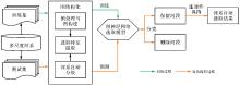
Fig. 4
Automatic selection process of river network supported by graph neural networks"


Fig. 5
Construction of dual and adjacent graphs of river network"
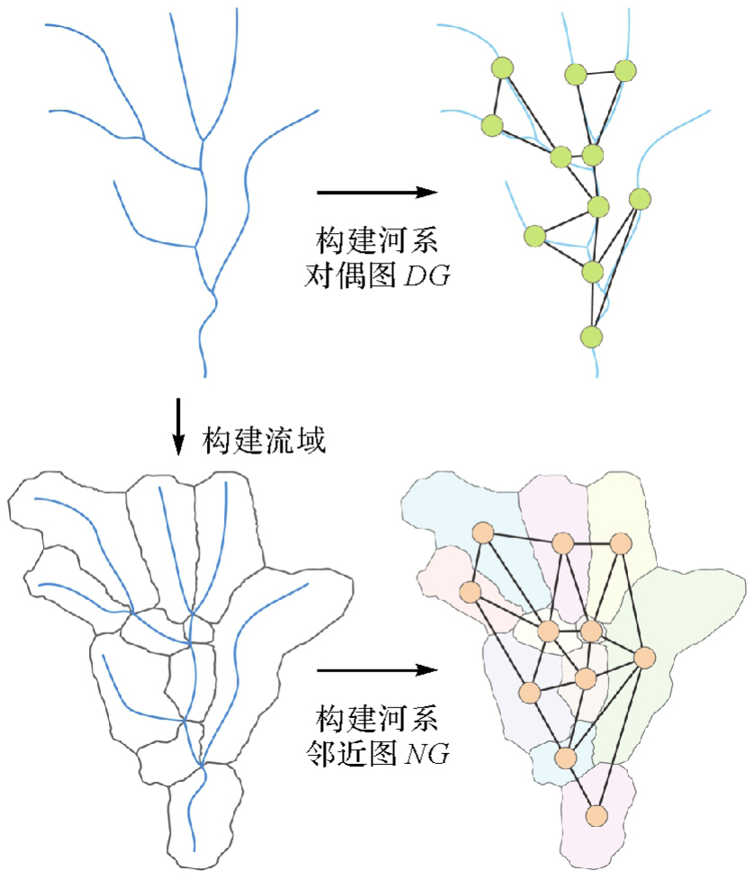
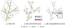
Fig. 6
The GraphSAGE operation"

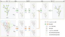
Fig. 7
Structure of river network selection model based on graph neural network"


Fig. 8
The maintaining connectivity while considering hierarchical levels"

Tab. 1
Statistic of experimental data for multiscale river network selection"
| 选取单元河段数统计 | 训练集(700) | 测试集(71) | ||
|---|---|---|---|---|
| 1∶24 000 | 1∶250 000 | 1∶24 000 | 1∶250 000 | |
| 平均值 | 627.7 | 212.2 | 549.0 | 191.9 |
| 最小值 | 85.0 | 37.0 | 137.0 | 49.0 |
| 最大值 | 1 684.0 | 556.0 | 1 476.0 | 460.0 |
Tab. 2
Statistic of experimental data for automatic classification of river network"
| 河系编号 | 训练集 | 河系编号 | 测试集 | ||||
|---|---|---|---|---|---|---|---|
| 主流数 | 支流数 | 图示 | 主流数 | 支流数 | 图示 | ||
| 河系1 | 133 | 132 | 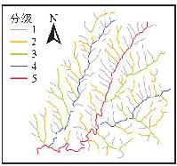 | 河系6 | 450 | 454 | 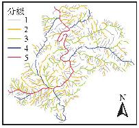 |
| 河系2 | 371 | 372 | 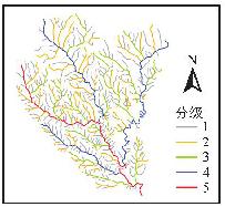 | 河系7 | 550 | 551 | 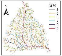 |
| 河系3 | 205 | 205 | 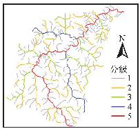 | 河系8 | 478 | 480 | 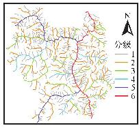 |
| 河系4 | 391 | 391 | 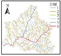 | 河系9 | 378 | 377 | 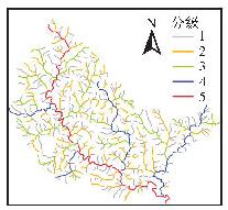 |
| 河系5 | 341 | 341 | 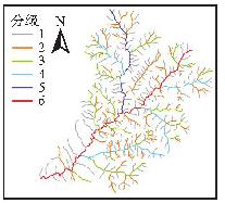 | 河系10 | 160 | 159 | 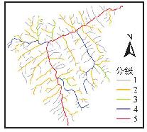 |
Tab. 3
Mainstream classification results of different standardization methods"
| 标准化方式 | 测试集分类准确率 | 主支流识别准确率 |
|---|---|---|
| Min-Max标准化 | 84.42 | 90.34 |
| Z-Score标准化 | 83.45 | 89.05 |
| 特征局部标准化 | 95.84 | 97.03 |
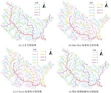
Fig. 9
Mainstream identification results of river network 9 using different standardization methods"

Tab. 4
Importance of characteristics in different standardization methods"
| 标准化方式 | 特征重要性 | |||||
|---|---|---|---|---|---|---|
| RLen | URL | WArea | URA | BAngle | URN | |
| Min-Max标准化 | 0.066 | 0.161 | 0.085 | 0.145 | 0.350 | 0.192 |
| Z-Score标准化 | 0.072 | 0.154 | 0.092 | 0.134 | 0.364 | 0.185 |
| 特征局部标准化 | 0.031 | 0.325 | 0.043 | 0.330 | 0.142 | 0.130 |
Tab. 5
Mainstream classification results of different machine learning algorithms"
| 机器学习算法 | 测试集分类准确率 | 主支流识别准确率 |
|---|---|---|
| 高斯分布朴素贝叶斯 | 92.62 | 94.60 |
| 决策树 | 93.88 | 93.85 |
| 随机森林 | 95.84 | 97.03 |

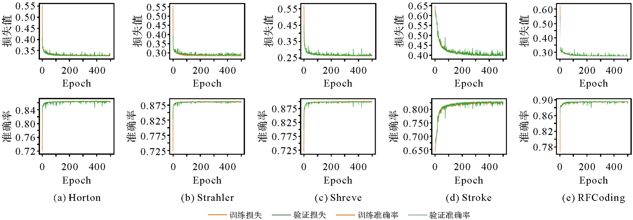
Fig. 10
Training process for river network selection considering a single classification code"
Tab. 6
Testing results for river network selection considering a single classification code"
| 分级方式 | 训练集 | 测试集 | |||
|---|---|---|---|---|---|
| 验证准确率 | 准确率 | 精度 | 召回率 | F1值 | |
| Hotron | 87.50 | 86.16 | 86.09 | 86.16 | 86.11 |
| Strahler | 88.69 | 88.29 | 88.29 | 88.09 | 88.07 |
| Shreve | 89.87 | 89.36 | 89.38 | 89.36 | 89.18 |
| Stroke | 82.59 | 81.89 | 81.62 | 81.89 | 81.63 |
| RFCoding | 89.83 | 89.56 | 89.49 | 89.56 | 89.49 |
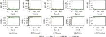
Fig. 11
Training process for river network selection considering multi feature combined classification code"

Tab. 7
Testing results for river network selection considering multi feature combined classification code"
| 特征组合 | 训练集 | 测试集 | |||
|---|---|---|---|---|---|
| 验证准确率 | 准确率 | 精度 | 召回率 | F1 | |
| +Hotron | 91.28 | 90.86 | 90.89 | 90.89 | 90.77 |
| +Strahler | 91.10 | 90.77 | 90.72 | 90.77 | 90.71 |
| +Shreve | 90.96 | 90.83 | 90.81 | 90.84 | 90.74 |
| +Stroke | 91.11 | 90.79 | 90.76 | 90.79 | 90.69 |
| +RFCoding | 92.01 | 91.80 | 91.76 | 91.80 | 91.77 |

Fig. 12
Training process of the proposed river network selection models based on graph neural network"

Tab. 8
Testing results of river network selection using different methods"
| 方法 | 精度 | 召回率 | F1 |
|---|---|---|---|
| 决策树 | 90.05 | 89.66 | 90.25 |
| 随机森林 | 90.23 | 89.82 | 90.06 |
| GAT法[ | 90.70 | 90.40 | 90.40 |
| GraphSAGE法[ | 91.20 | 90.60 | 90.70 |
| 本文单支选取模型 | 92.36 | 92.39 | 92.33 |
| 本文双支选取模型 | 92.63 | 92.66 | 92.62 |
Tab. 9
Statistical results of maintaining connectivity through different methods"
| 初始数据 | 方法 | 精度 | 选取标签的精度 | 选取标签的召回率 | 选取标签的F1值 |
|---|---|---|---|---|---|
| 单支选取模型结果 | 连通处理前 | 92.36 | 91.72 | 85.98 | 88.76 |
| 最长路径法 | 93.00 | 86.90 | 93.36 | 90.01 | |
| 层次连通法 | 93.32 | 91.46 | 89.28 | 90.36 | |
| 双支选取模型结果 | 连通处理前 | 92.63 | 91.50 | 87.10 | 89.25 |
| 最长路径法 | 93.22 | 87.03 | 93.83 | 90.30 | |
| 层次连通法 | 93.40 | 91.15 | 89.89 | 90.52 |
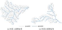
Fig. 13
Selection labels for river network A and B"

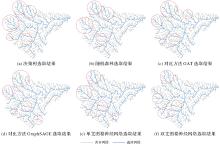
Fig. 14
Visual comparison of selection results for river network A using different methods"

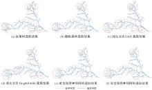
Fig. 15
Visual comparison of selection results for river network B using different methods"

| [1] | 谭笑, 武芳, 黄琦, 等. 主流识别的多准则决策模型及其在河系结构化中的应用[J]. 测绘学报, 2005, 34(2): 154-160. |
| TAN Xiao, WU Fang, HUANG Qi, et al. A multi-criteria decision model for identifying master river and its application in river system construction[J]. Acta Geodaetica et Cartographic Sinica, 2005, 34(2): 154-160. | |
| [2] |
YU Huafei, AI Tinghua, YANG Min, et al. A recognition method for drainage patterns using a graph convolutional network[J]. International Journal of Applied Earth Observation and Geoinformation, 2022, 107: 102696. DOI: .
doi: 10.1016/j.jag.2022.102696 |
| [3] |
YU Huafei, AI Tinghua, YANG Min, et al. A graph autoencoder network to measure the geometric similarity of drainage networks in scaling transformation[J]. International Journal of Digital Earth, 2023, 16(1): 1828-1852. DOI: .
doi: 10.1080/17538947.2023.2212920 |
| [4] |
WANG Wenning, YAN Haowen, LU Xiaomin, et al. Drainage pattern recognition method considering local basin shape based on graph neural network[J]. International Journal of Digital Earth, 2023, 16(1): 593-619. DOI: .
doi: 10.1080/17538947.2023.2172224 |
| [5] |
YU Huafei, AI Tinghua, YANG Min, et al. Integrating domain knowledge and graph convolutional neural networks to support river network selection[J]. Transactions in GIS, 2023, 27(7): 1898-1927. DOI: .
doi: 10.1111/tgis.13104 |
| [6] |
WANG Di, QIAN Haizhong. Graph neural network method for the intelligent selection of river system[J]. Geocarto International, 2023, 38: 2252762. DOI: .
doi: 10.1080/10106049.2023.2252762 |
| [7] |
段佩祥, 钱海忠, 何海威, 等. 案例支撑下的朴素贝叶斯树状河系自动分级方法[J]. 测绘学报, 2019, 48(8): 975-984. DOI: .
doi: 10.11947/j.AGCS.2019.20180370 |
|
DUAN Peixiang, QIAN Haizhong, HE Haiwei, et al. Naive Bayes-based automatic classification method of tree-like river network supported by cases[J]. Acta Geodaetica et Cartographica Sinica, 2019, 48(8): 975-984. DOI: .
doi: 10.11947/j.AGCS.2019.20180370 |
|
| [8] | HORTON R E. Erosional development of streams and their drainage basins; hydrophysical approach to quantitative morphology[J]. Geological Society of America Bulletin, 1945, 56(3): 275-370. |
| [9] |
STRAHLER A N. Quantitative analysis of watershed geomorphology[J]. Eos, Transactions American Geophysical Union, 1957, 38(6): 913-920. DOI: .
doi: 10.1029/TR038i006p00913 |
| [10] | SHREVE R L. Statistical law of stream numbers[J]. The Journal of Geology, 1966, 74(1): 17-37. |
| [11] | 张园玉, 李霖, 金玉平, 等. 基于图论的树状河系结构化绘制模型研究[J]. 武汉大学学报(信息科学版), 2004, 29(6): 537-539, 543. |
| ZHANG Yuanyu, LI Lin, JIN Yuping, et al. Structured design of dendritic river networks based on graph[J]. Geomatics and Information Science of Wuhan University, 2004, 29(6): 537-539, 543. | |
| [12] | 翟仁键, 薛本新. 面向自动综合的河系结构化模型研究[J]. 测绘科学技术学报, 2007, 24(4): 294-298, 302. |
| ZHAI Renjian, XUE Benxin. A structural river network data model for automated river generalization[J]. Journal of Zhengzhou Institute of Surveying and Mapping, 2007, 24(4): 294-298, 302. | |
| [13] | 郭庆胜, 黄远林. 树状河系主流的自动推理[J]. 武汉大学学报(信息科学版), 2008, 33(9): 978-981. |
| GUO Qingsheng, HUANG Yuanlin. Automatic reasoning on main streams of tree river networks[J]. Geomatics and Information Science of Wuhan University, 2008, 33(9): 978-981. | |
| [14] | PAIVA J, EGENHOFER M J, FRANK A U. Spatial reasoning about flow directions: towards an ontology for river networks[C]//Proceedings of 1992 XV International Congress for Photogrammetry and Remote Sensing. [S. l.]: ISPRS, 1992: 224-318. |
| [15] |
李成名, 殷勇, 吴伟, 等. Stroke特征约束的树状河系层次关系构建及简化方法[J]. 测绘学报, 2018, 47(4): 537-546. DOI: .
doi: 10.11947/i.AGCS.2018.20170141 |
|
LI Chengming, YIN Yong, WU Wei, et al. Method of tree-like river networks hierarchical relation establishing and generalization considering Stroke properties[J]. Acta Geodaetica et Cartographica Sinica, 2018, 47(4): 537-546. DOI: .
doi: 10.11947/i.AGCS.2018.20170141 |
|
| [16] | THOMSON R C, RICHARDSON D E. The “good continuation” principle of perceptual organization applied to the generalization of road networks[C]//Proceedings of the ICA 19th international cartographic conference. Ottawa: IEEE, 1999: 1215-1223. |
| [17] | 翟仁健, 武芳, 邓红艳, 等. 基于遗传多目标优化的河流自动选取模型[J]. 中国矿业大学学报, 2006, 35(3): 403-408. |
| ZHAI Renjian, WU Fang, DENG Hongyan, et al. Automated elimination of river based on multi-objective optimization using genetic algorithm[J]. Journal of China University of Mining & Technology, 2006, 35(3): 403-408. | |
| [18] | 艾廷华, 刘耀林, 黄亚锋. 河网汇水区域的层次化剖分与地图综合[J]. 测绘学报, 2007, 36(2): 231-236, 243. |
| AI Tinghua, LIU Yaolin, HUANG Yafeng. The hierarchical watershed partitioning and generalization of river network[J]. Acta Geodaetica et Cartographica Sinica, 2007, 36(2): 231-236, 243. | |
| [19] | 邵黎霞, 何宗宜, 艾自兴, 等. 基于BP神经网络的河系自动综合研究[J]. 武汉大学学报(信息科学版), 2004, 29(6): 555-557. |
| SHAO Lixia, HE Zongyi, AI Zixing, et al. Automatic generalization of river network based on BP neural network techniques[J]. Geomatics and Information Science of Wuhan University, 2004, 29(6): 555-557. | |
| [20] | SEN A, GOKGOZ T, SESTER M. Model generalization of two different drainage patterns by self-organizing maps[J]. Cartography and Geographic Information Science, 2014, 41(2): 151-165. |
| [21] | SEN A, GOKGOZ T. An experimental approach for selection/elimination in stream network generalization using support vector machines[J]. Geocarto International, 2015, 30(3): 311-329. |
| [22] | YAN Chaode, LIU Xiao, BOOTA M W, et al. A comparison of machine learning methods applied to the automated selection of river networks[J]. The Cartographic Journal, 2022, 59(3): 187-202. |
| [23] | NIEPERT M, AHMED M, KUTZKOV K. Learning convolutional neural networks for graphs[C]//Proceedings of the 33rd International Conference on Machine Learning. New York: IEEE, 2016: 2014-2023. |
| [24] | KIPF T N, WELLING M. Semi-supervised classification with graph convolutional networks[EB/OL]. [2025-01-25]. https//arxiv.org/abs1609. |
| [25] |
HAMILTON W, YING Z. LESKOVEC J. Inductive representation learning on large graphs[C]//Proceedings of the 31st International Conference on Neural Information Processing Systems. California: IEEE, 2017: 1025-1035. DOI: .
doi: 10.48550/arXiv.1706.02216 |
| [26] | BREIMAN L. Random forests[J]. Machine Learning, 2001, 45(1): 5-32. |
| [27] | HOCHREITER S, SCHMIDHUBER J. Long short-term memory[J]. Neural Computation, 1997, 9(8): 1735-1780. |
| [1] | Yaqing WANG, Zhonghui WANG. River network automated selection method based on heterogeneous graph convolutional networks [J]. Acta Geodaetica et Cartographica Sinica, 2025, 54(7): 1332-1345. |
| [2] | Zhekun HUANG, Haizhong QIAN, Zhongxiang CAI, Xiao WANG, Junwei WANG, Linghui KONG. A multi-scale mesh river system classification matching method based on graph neural network [J]. Acta Geodaetica et Cartographica Sinica, 2025, 54(2): 371-384. |
| [3] | Jiayi TANG, Xiaochong TONG, Chunping QIU, Yaxian LEI, Yi LEI, Haoshuai SONG. Remote sensing scene retrieval method based on scene graph [J]. Acta Geodaetica et Cartographica Sinica, 2025, 54(1): 123-135. |
| [4] | Chao CHEN, Jintao LIANG, Gang YANG, Weiwei SUN, Shaojun GONG, Jianqiang WANG. Remote sensing parameters optimization for accurate land cover classification [J]. Acta Geodaetica et Cartographica Sinica, 2024, 53(7): 1401-1416. |
| [5] | Bo KONG, Tinghua AI, Min YANG, Hao WU, Huafei YU, Tianyuan XIAO. Identification of loess landform types jointly affected by contour morphological knowledge and the graph neural network [J]. Acta Geodaetica et Cartographica Sinica, 2024, 53(6): 1154-1164. |
| [6] | Zhanlong CHEN, Xiechun LU, Yongyang XU. A building aggregation method based on deep clustering of graph vertices [J]. Acta Geodaetica et Cartographica Sinica, 2024, 53(4): 736-749. |
| [7] | WANG Lanxing, WANG Qunming, TONG Xiaohua. Thick cloud removal of hyperspectral images by fusing with multispectral images [J]. Acta Geodaetica et Cartographica Sinica, 2022, 51(4): 612-621. |
| [8] | WANG Meng, ZHANG Xinchang, WANG Jiayao, SUN Ying, JIAN Ge, PAN Cuihong. Forest resource classification based on random forest and object oriented method [J]. Acta Geodaetica et Cartographica Sinica, 2020, 49(2): 235-244. |
| [9] | DUAN Peixiang, QIAN Haizhong, HE Haiwei, XIE Limin, LUO Denghan. Naive Bayes-based automatic classification method of tree-like river network supported by cases [J]. Acta Geodaetica et Cartographica Sinica, 2019, 48(8): 975-984. |
| [10] | XIONG Yan, GAO Renqiang, XU Zhanya. Random Forest Method for Dimension Reduction and Point Cloud Classification Based on Airborne LiDAR [J]. Acta Geodaetica et Cartographica Sinica, 2018, 47(4): 508-518. |
| [11] | YANG Juntao, KANG Zhizhong. Multi-scale Features and Markov Random Field Model for Powerline Scene Classification [J]. Acta Geodaetica et Cartographica Sinica, 2018, 47(2): 188-197. |
| [12] | ZHANG Zhiqiang, ZHANG Xinchang, XIN Qinchuan, YANG Xiaoling. Combining the Pixel-based and Object-based Methods for Building Change Detection Using High-resolution Remote Sensing Images [J]. Acta Geodaetica et Cartographica Sinica, 2018, 47(1): 102-112. |
| [13] | FENG Wenqing, SUI Haigang, TU Jihui, SUN Kaimin, HUANG Weiming. Change Detection Method for High Resolution Remote Sensing Images Using Random Forest [J]. Acta Geodaetica et Cartographica Sinica, 2017, 46(11): 1880-1890. |
| Viewed | ||||||
|
Full text |
|
|||||
|
Abstract |
|
|||||