

Acta Geodaetica et Cartographica Sinica ›› 2026, Vol. 55 ›› Issue (3): 536-547.doi: 10.11947/j.AGCS.2026.20250377
• Cartography and Geographic Information • Previous Articles Next Articles
Xiaoqiang CHENG1,2( ), Jiawei ZHAO1, Pengcheng LIU3,4()
Received:2025-08-28
Revised:2026-03-03
Online:2026-04-16
Published:2026-04-16
Contact:
Pengcheng LIU
E-mail:carto@hubu.edu.cn;liupc@ccnu.edu.cn
About author:CHENG Xiaoqiang (1985—), male, PhD, associate professor, majors in geographic information visualization. E-mail: carto@hubu.edu.cn
Supported by:CLC Number:
Xiaoqiang CHENG, Jiawei ZHAO, Pengcheng LIU. Spatial interaction visualization based on the distance-similarity metaphor[J]. Acta Geodaetica et Cartographica Sinica, 2026, 55(3): 536-547.
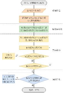
Fig. 1
The flowchart of SITC layout algorithm"
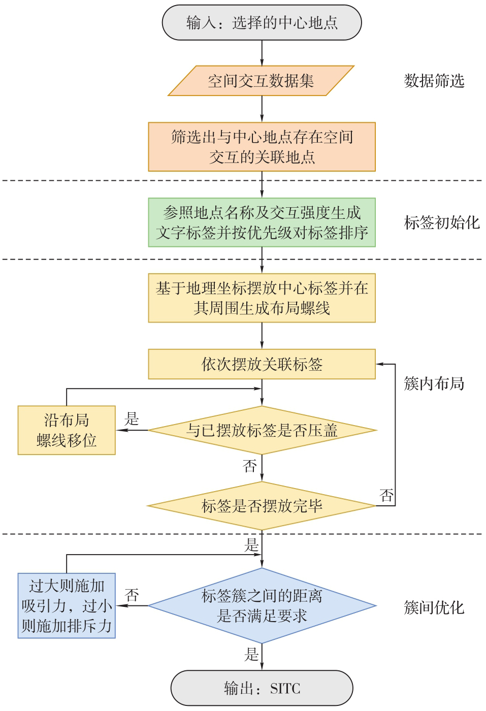
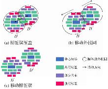
Fig. 2
Repelling tag clusters"
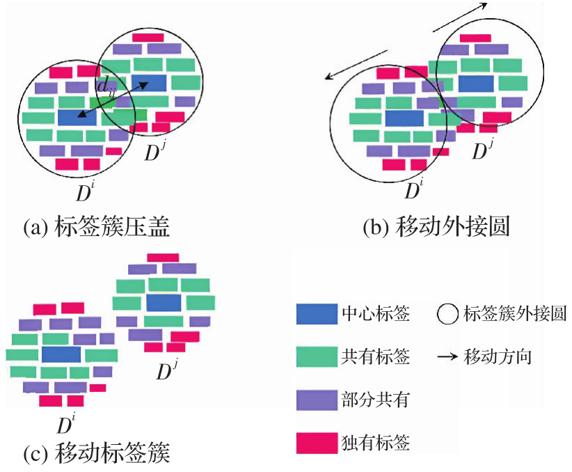
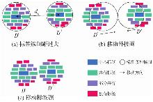
Fig. 3
Attracting tag clusters"

Fig. 4
Spatial interaction tag cloud with a single central node"


Fig. 5
Single-centered spatial interaction tag cloud representing bidirectional interactions"


Fig. 6
Spatial interaction tag clouds with Shanghai and Tianjin as centers"


Fig. 7
Spatial interaction tag clouds with Beijing, Shanghai and Guangzhou as centers"


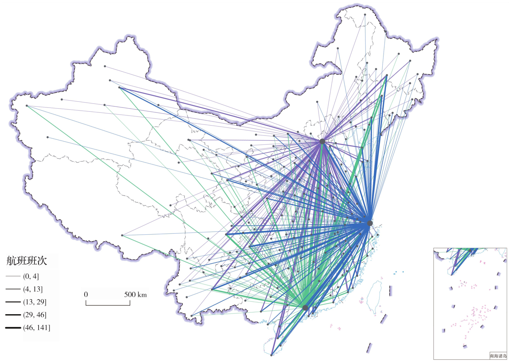
Fig. 8
Flow map based on flight data"
Tab. 1
Accuracy and abandonment rates of objective tasks in the user cognition experiment"
| 编号 | 问题 | 准确率/(%) | 放弃率/(%) | ||
|---|---|---|---|---|---|
| SITC | 流地图 | SITC | 流地图 | ||
| 1 | 哪些城市到这3个中心城市均有直飞航班?找出3个 | 97.4 | 43.0 | 0.0 | 53.5 |
| 2 | 找出飞往上海航班数量最多的前3个城市 | 55.3 | 16.7 | 0.0 | 76.3 |
| 3 | 找出只到广州有航班的3个城市 | 91.2 | 15.0 | 7.9 | 80.7 |
| 4 | 杭州是否有航班飞往这3个中心城市 | 86.0 | 29.0 | 1.7 | 59.6 |
| 5 | 哪些城市到北京有航班,但是到广州没有航班?找出3个 | 91.2 | 2.6 | 3.5 | 89.5 |
Tab. 2
Subjective question scores of the user cognition experiment"
| 编号 | 问题 | 得分 | |
|---|---|---|---|
| SITC | 流地图 | ||
| 1 | 在阅读该图时,你是否能迅速理解城市之间的航班关系 | 5.3 | 2.5 |
| 2 | 阅读该图是否让你感到信息过载或视觉混乱 | 4.6 | 1.8 |
| 3 | 你认为回答问题1—5是否容易 | 4.9 | 1.8 |
Tab. 3
Comparison between SITC and mainstream spatial interaction visualization methods"
| 可视化能力 | 传统流地图 | 边绑定流地图 | 矩阵图Maptrix | Kriskograms | SITC本文方法 |
|---|---|---|---|---|---|
| 节点清晰表达 | ✕ | ✕ | ✕ | ✕ | √ |
| 交互关系存在性判断 | ✕ | ✕ | √ | √ | √ |
| 整体交互模式呈现 | ✕ | √ | √ | ✕ | ✕ |
| 中心交互规模感知 | ✕ | ✕ | √ | √ | √ |
| 具体交互对象快速识别 | ✕ | ✕ | ✕ | ✕ | √ |
| 相对强度比较 | √ | √ | √ | √ | √ |
| 多中心共享关系发现 | ✕ | ✕ | ✕ | ✕ | √ |
| 数据规模可扩展性 | ✕ | √ | ✕ | ✕ | √ |
| 空间保真 | √ | √ | ✕ | ✕ | ✕ |
| 总评 | 7个✕ | 5个✕ | 5个✕ | 6个✕ | 2个✕ |
| [1] | 刘瑜, 姚欣, 龚咏喜, 等. 大数据时代的空间交互分析方法和应用再论[J]. 地理学报, 2020, 75(7): 1523-1538. |
| LIU Yu, YAO Xin, GONG Yongxi, et al. Analytical methods and applications of spatial interactions in the era of big data[J]. Acta Geographica Sinica, 2020, 75(7): 1523-1538. | |
| [2] | ROY J R, THILL J C. Spatial interaction modelling[J]. Papers in Regional Science, 2004, 83(1): 339-361. |
| [3] | 裴韬. 地理流空间分析[M]. 北京: 科学出版社, 2024. |
| PEI Tao. Spatial analysis of geographic flow[M]. Beijing: Science Press, 2024. | |
| [4] | ABEL G J, SANDER N. Quantifying global international migration flows[J]. Science, 2014, 343(6178): 1520-1522. |
| [5] | SCHÖTTLER S, YANG Yalong, PFISTER H, et al. Visualizing and interacting with geospatial networks: a survey and design space[J]. Computer Graphics Forum, 2021, 40(6): 5-33. |
| [6] | GU Yuhang, KRAAK M J, ENGELHARDT Y, et al. A classification scheme for static origin-destination data visualizations[J]. International Journal of Geographical Information Science, 2023, 37(9): 1970-1997. |
| [7] | TENNEKES M, CHEN Min. Design space of origin-destination data visualization[J]. Computer Graphics Forum, 2021, 40(3): 323-334. |
| [8] | 涂乐, 陈彬捷, 周志光. OD数据可视分析综述[J]. 计算机辅助设计与图形学学报, 2021, 33(8): 1160-1171. |
| TU Le, CHEN Binjie, ZHOU Zhiguang. A survey on OD data visualization[J]. Journal of Computer-Aided Design & Computer Graphics, 2021, 33(8): 1160-1171. | |
| [9] | JENNY B, STEPHEN D M, MUEHLENHAUS I, et al. Design principles for origin-destination flow maps[J]. Cartography and Geographic Information Science, 2018, 45(1): 62-75. |
| [10] | 王录仓, 刘海洋, 刘清. 基于腾讯迁徙大数据的中国城市网络研究[J]. 地理学报, 2021, 76(4): 853-869. |
| WANG Lucang, LIU Haiyang, LIU Qing. China's city network based on Tencent's migration big data[J]. Acta Geographica Sinica, 2021, 76(4): 853-869. | |
| [11] | MA Yunfei, AMIRI A, HASSINI E, et al. Transportation data visualization with a focus on freight: a literature review[J]. Transportation Planning and Technology, 2022, 45(4): 358-401. |
| [12] | 胡定利, 李锐, 孟瑶, 等. 新闻地名共现视角下的中国城市网络[J]. 武汉大学学报(信息科学版), 2020, 45(2): 281-288. |
| HU Dingli, LI Rui, MENG Yao, et al. China's urban network from the perspective of toponym co-occurrences in the news[J]. Geomatics and Information Science of Wuhan University, 2020, 45(2): 281-288. | |
| [13] | GUO Diansheng, ZHU Xi. Origin-destination flow data smoothing and mapping[J]. IEEE Transactions on Visualization and Computer Graphics, 2014, 20(12): 2043-2052. |
| [14] | JENNY B, STEPHEN D M, MUEHLENHAUS I, et al. Force-directed layout of origin-destination flow maps[J]. International Journal of Geographical Information Science, 2017, 31(8): 1521-1540. |
| [15] | ZHU Xi, GUO Diansheng, KOYLU C, et al. Density-based multi-scale flow mapping and generalization[J]. Computers, Environment and Urban Systems, 2019, 77: 101359. |
| [16] | ZHOU Hong, XU Panpan, YUAN Xiaoru, et al. Edge bundling in information visualization[J]. Tsinghua Science and Technology, 2013, 18(2): 145-156. |
| [17] | BUCHIN K, SPECKMANN B, VERBEEK K. Flow map layout via spiral trees[J]. IEEE Transactions on Visualization and Computer Graphics, 2011, 17(12): 2536-2544. |
| [18] | SUN Shipeng. A spatial one-to-many flow layout algorithm using triangulation, approximate Steiner trees, and path smoothing[J]. Cartography and Geographic Information Science, 2019, 46(3): 243-259. |
| [19] | VIAU L, SALLABERRY A, RODRIGUEZ N, et al. Polygon vector map distortion for increasing the readability of one-to-many flow maps[J]. International Journal of Geographical Information Science, 2023, 37(6): 1288-1314. |
| [20] | YANG Yalong, DWYER T, GOODWIN S, et al. Many-to-many geographically-embedded flow visualisation: an evaluation[J]. IEEE Transactions on Visualization and Computer Graphics, 2017, 23(1): 411-420. |
| [21] | XIAO Ningchuan, CHUN Yongwan. Visualizing migration flows using kriskograms[J]. Cartography and Geographic Information Science, 2009, 36(2): 183-191. |
| [22] | ZHOU Mengjie, FU Qingyang, LI Yige, et al. Discovering spatiotemporal flow patterns: where the origin-destination map meets empirical orthogonal function decomposition[J]. Cartography and Geographic Information Science, 2023, 50(2): 113-129. |
| [23] | OTTEN H, HILDEBRAND L, NAGEL T, et al. Shifted maps: revealing spatio-temporal topologies in movement data[C]//Proceedings of 2018 IEEE VIS Arts Program. Berlin: IEEE, 2018: 1-10. |
| [24] | STEPHEN D M, JENNY B. Automated layout of origin-destination flow maps: U. S.county-to-county migration 2009—2013[J]. Journal of Maps, 2017, 13(1): 46-55. |
| [25] | BOUTS Q W, DWYER T, DYKES J, et al. Visual encoding of dissimilarity data via topology-preserving map deformation[J]. IEEE Transactions on Visualization and Computer Graphics, 2016, 22(9): 2200-2213. |
| [26] | FABRIKANT S I, MONTELLO D R, RUOCCO M, et al. The distance-similarity metaphor in network-display spatializations[J]. Cartography and Geographic Information Science, 2004, 31(4): 237-252. |
| [27] | MONTELLO D R, FABRIKANT S I, RUOCCO M, et al. Testing the first law of cognitive geography on point-display spatializations[C]//Proceedings of 2023 International Conference on Spatial Information Theory. Berlin: Springer, 2003: 316-331. |
| [28] | DRAPER G M, LIVNAT Y, RIESENFELD R F. A survey of radial methods for information visualization[J]. IEEE Transactions on Visualization and Computer Graphics, 2009, 15(5): 759-776. |
| [29] | JÄNICKE S, SCHEUERMANN G. TagSpheres: visualizing hierarchical relations in tag clouds[C]//Proceedings of the 11th Joint Conference on Computer Vision, Imaging and Computer Graphics Theory and Applications. Rome: [s.n.], 2016: 17-28. |
| [30] | CHENG Xiaoqiang, LIU Zhongyu, WU Huayi, et al. LBS tag cloud: a centralized tag cloud for visualization of points of interest in location-based services[J]. ISPRS International Journal of Geo-Information, 2023, 12(9): 360. |
| [31] | 包琛, 汪云海. 词云可视化综述[J]. 计算机辅助设计与图形学学报, 2021, 33(4): 532-44. |
| BAO Chen, WANG Yunhai. A survey of word cloud visualization[J]. Journal of Computer-Aided Design & Computer Graphics, 2021, 33(4): 532-44. | |
| [32] | YANG Nai, MACEACHREN A M, DOMANICO E. Utility and usability of intrinsic tag maps[J]. Cartography and Geographic Information Science, 2020, 47(4): 291-304. |
| [33] | BOSTOCK M, OGIEVETSKY V, HEER J. D3 data-driven documents[J]. IEEE Transactions on Visualization and Computer Graphics, 2011, 17(12): 2301-2309. |
| [34] | PAN Jinghu, LAI Jianbo. Spatial pattern of population mobility among cities in China: case study of the National Day plus Mid-Autumn Festival based on Tencent migration data[J]. Cities, 2019, 94: 55-69. |
| [1] | Xini HU, Mengjun KANG, Liang GE, Shiliang SU, Min WENG. Intelligent design of terrain visualization for online maps [J]. Acta Geodaetica et Cartographica Sinica, 2026, 55(4): 739-752. |
| [2] | Haojia LIN, Renzhong GUO, Biao HE, Xi KUAI, Ding MA, Chengpeng LI. Visual-perception-oriented LOD adaptive visualization for realistic 3D building scenes [J]. Acta Geodaetica et Cartographica Sinica, 2025, 54(6): 1054-1070. |
| [3] | Deren LI, Mi WANG, Wenbin SHEN, Qingyun DU, Shuo WANG. On the development of surveying and mapping in the era of artificial intelligence [J]. Acta Geodaetica et Cartographica Sinica, 2025, 54(12): 2107-2115. |
| [4] | LIU Xiaobo, TU Jianguang, ZHANG Haifeng, LI Zhijiang. Optimization and scheduling of tile loading for three-dimensional model of land consolidation [J]. Acta Geodaetica et Cartographica Sinica, 2022, 51(4): 522-533. |
| [5] | SHANG Daiyu, DING Yulin, ZHU Qing, WU Linbao. A multi-resolution texture-based visualization method for geographic vector fields by means of spatial variation features [J]. Acta Geodaetica et Cartographica Sinica, 2020, 49(5): 656-666. |
| [6] | LU Wanjie, XU Qing, LAN Chaozhen, Lü Liang, ZHOU Yang. A real-time analysis and visualization for area coverage of remote sensing satellite [J]. Acta Geodaetica et Cartographica Sinica, 2020, 49(10): 1321-1330. |
| [7] | LI Xiang, WANG Lina, ZHANG Weidong, YANG Fei, YANG Zhenkai. A visualization method of continuous area cartogram for two or multiple variables [J]. Acta Geodaetica et Cartographica Sinica, 2019, 48(6): 756-766. |
| [8] | ZHANG Xu, HAO Xiangyang, LI Jiansheng, LI Pengyue. Fusion and visualization method of dynamic targets in surveillance video with geospatial information [J]. Acta Geodaetica et Cartographica Sinica, 2019, 48(11): 1415-1423. |
| [9] | GONG Jianhua, LI Wenhang, ZHANG Guoyong, SHEN Shen, HUANG Lin, SUN Jun. An Augmented Geographic Environment for Geo-process Visualization-A Case of Crowd Evacuation Simulation [J]. Acta Geodaetica et Cartographica Sinica, 2018, 47(8): 1089-1097. |
| [10] | LIU Mingwei, ZHU Qing, ZHU Jun, FENG Bin, LI Yun, ZHANG Junxiao, FU Xiao, ZHANG Pengcheng, YANG Weijun, NING Xinwen, XU Wanyan. The Multi-level Visualization Task Model for Multi-modal Spatio-temporal Data [J]. Acta Geodaetica et Cartographica Sinica, 2018, 47(8): 1098-1104. |
| [11] | WANG Lina, LI Xiang, JIANG Nan, YANG Zhenkai, YANG Fei. A New Method of Constructing a Central Time-space Map [J]. Acta Geodaetica et Cartographica Sinica, 2018, 47(1): 123-132. |
| [12] | AI Tinghua, ZHOU Mengjie, LI Xiaoming. Mining Co-location Pattern of Network Spatial Phenomenon Based on the Law of Additive Color Mixing [J]. Acta Geodaetica et Cartographica Sinica, 2017, 46(6): 753-759. |
| [13] | LIU Jiping, ZHANG Fuhao, XU Shenghua. Progresses and Prospects in Geospatial Big Data for E-government [J]. Acta Geodaetica et Cartographica Sinica, 2017, 46(10): 1678-1687. |
| [14] | HUANG Wumeng, CHEN Jing. An Optimization Method for Virtual Globe Ocean Surface Dynamic Visualization [J]. Acta Geodaetica et Cartographica Sinica, 2016, 45(S1): 135-143. |
| [15] | ZHANG Xiang, WANG Shaodong, WANG Yuxia. Clutter-free Visualization of Large Point Symbols at Multiple Scales by Offset Quadtrees [J]. Acta Geodaetica et Cartographica Sinica, 2016, 45(8): 983-991. |
| Viewed | ||||||
|
Full text |
|
|||||
|
Abstract |
|
|||||