

Acta Geodaetica et Cartographica Sinica ›› 2026, Vol. 55 ›› Issue (5): 850-865.doi: 10.11947/j.AGCS.2026.20250474
• Geodesy and Navigation • Previous Articles Next Articles
Nijia QIAN1( ), Xun ZHANG1, Guobin CHANG1,2,3(), Hefang BIAN1, Huachao YANG1, Xiannan HAN2
Received:2025-11-11
Revised:2026-04-20
Online:2026-06-23
Published:2026-06-23
Contact:
Guobin CHANG
E-mail:nijiaqian@cumt.edu.cn;guobinchang@hotmail.com
About author:QIAN Nijia (1995—), male, PhD, associate professor, majors in gravity field modeling, satellite gravimetry, satellite navigation and positioning applications. E-mail: nijiaqian@cumt.edu.cn
Supported by:CLC Number:
Nijia QIAN, Xun ZHANG, Guobin CHANG, Hefang BIAN, Huachao YANG, Xiannan HAN. A greedy sparse approximation method for least squares collocation[J]. Acta Geodaetica et Cartographica Sinica, 2026, 55(5): 850-865.
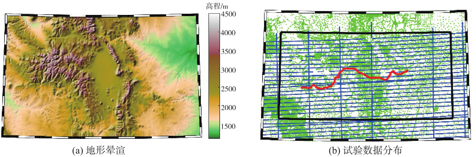
Fig. 1
Overview of the study area"
Tab. 1
Statistical characteristics of observational data before and after the removal of reference gravity field"
| 数据类型 | STD | Max | Min | Mean |
|---|---|---|---|---|
| 地面重力δg | 36.72 | 207.89 | -92.86 | -3.26 |
| 地面重力δgres | 6.86 | 75.64 | -51.05 | 0.81 |
| 航空重力δg | 32.00 | 123.89 | -42.29 | 13.06 |
| 航空重力δgres | 3.54 | 18.28 | -16.57 | 0.36 |
Fig. 2
Numerical distribution of observational data before and after the “remove” step of reference gravity field"

Tab. 2
External validation accuracy and computation time for geoid models derived from MP, OMP, and LSC algorithms under different sparsity levels"
| 算法 | 稀疏度 | 解算时间/h | 外部检验误差 | |||
|---|---|---|---|---|---|---|
| STD/cm | Max/cm | Min/cm | Mean/cm | |||
| LSC | 51 629 | 0.05 | 2.27 | 5.28 | -3.84 | 1.25 |
| MP | 477 | 0.04 | 2.49 | 5.90 | -4.33 | 0.96 |
| 1176 | 0.14 | 2.36 | 5.25 | -3.81 | 1.03 | |
| 1429 | 0.18 | 2.38 | 5.25 | -4.01 | 1.07 | |
| 2081 | 0.31 | 2.37 | 5.22 | -4.22 | 1.07 | |
| 2570 | 0.50 | 2.32 | 5.21 | -4.17 | 1.10 | |
| 3139 | 0.61 | 2.31 | 5.24 | -4.33 | 1.10 | |
| OMP | 500 | 0.06 | 2.39 | 5.28 | -3.99 | 1.32 |
| 1000 | 0.18 | 2.24 | 5.36 | -4.42 | 1.31 | |
| 1500 | 0.37 | 2.25 | 5.28 | -4.30 | 1.18 | |
| 2000 | 0.65 | 2.25 | 5.31 | -4.20 | 1.19 | |
Fig. 3
Variation of external validation accuracy for the two greedy configuration algorithms under different sparsity levels"
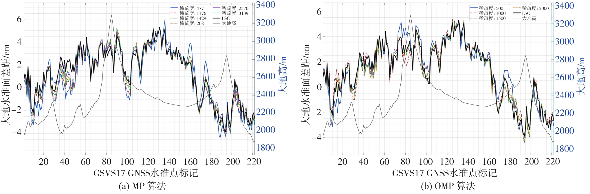
Fig. 4
Standard deviations of standard differences from the GSVS17 geoid and computation time for MP, OMP, and LSC algorithms under different sparsity levels"
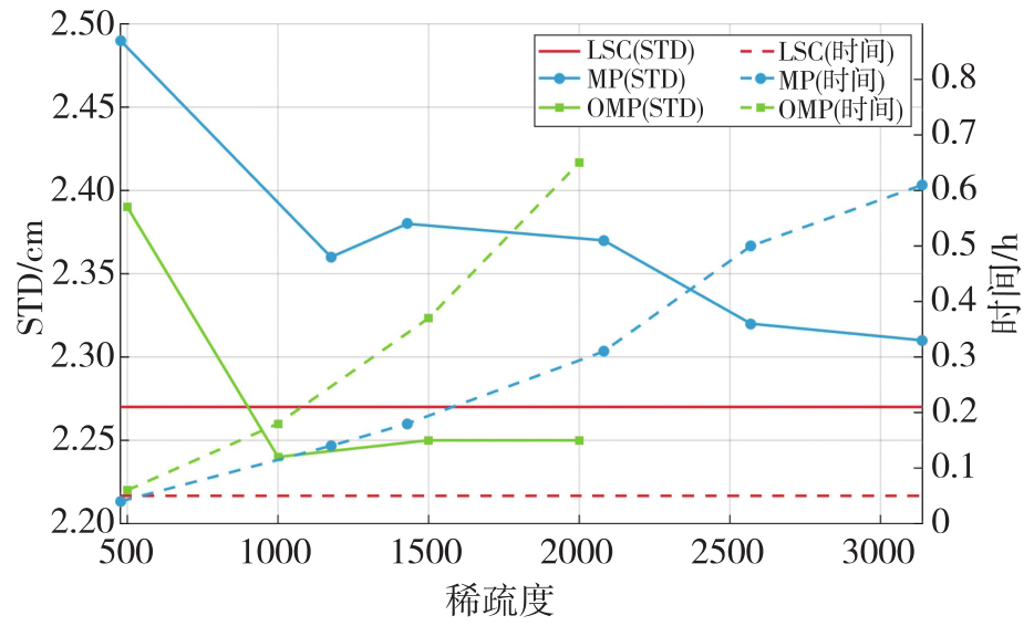
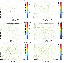
Fig. 5
Spatial distribution of non-zero coefficients derived from the MP algorithm under different sparsity levels"
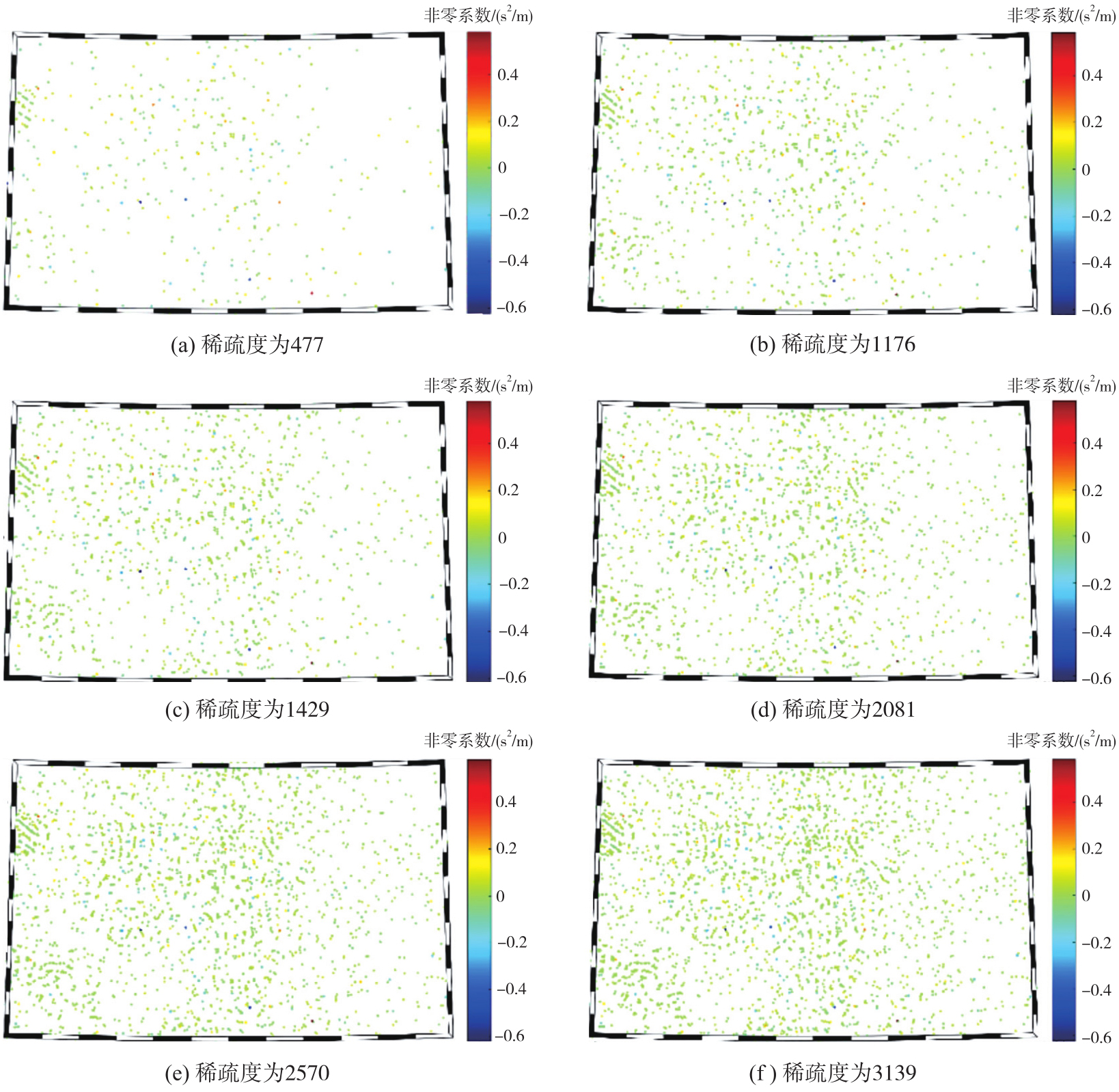
Fig. 6
Spatial distribution of non-zero coefficients derived from the OMP algorithm under different sparsity levels"
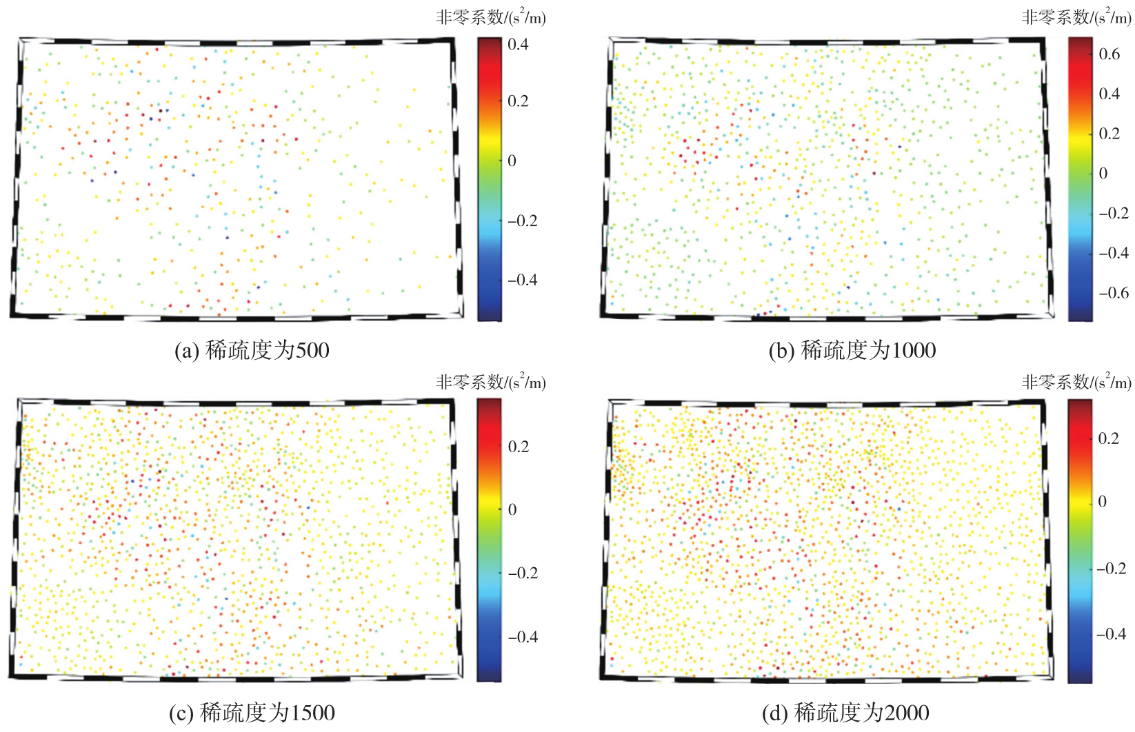
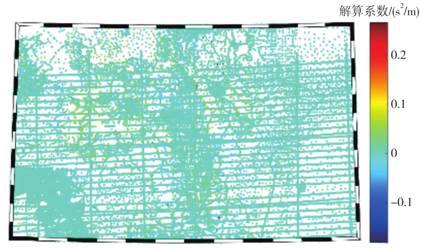
Fig. 7
Spatial distribution of coefficients derived from the LSC algorithm"
Tab. 3
Fitting residuals for gravity disturbance observations derived from different algorithms"
| 算法 | 稀疏度 | 残差/mGal | |||
|---|---|---|---|---|---|
| STD | Max | Min | Mean | ||
| LSC | 51 629 | 2.66 | 66.52 | -44.98 | 0.48 |
| MP | 477 | 3.37 | 70.09 | -48.44 | 0.59 |
| 1176 | 3.11 | 68.66 | -47.74 | 0.57 | |
| 1429 | 3.05 | 68.44 | -46.96 | 0.56 | |
| 2081 | 2.95 | 68.12 | -46.08 | 0.54 | |
| 2570 | 2.89 | 67.45 | -45.59 | 0.53 | |
| 3139 | 2.84 | 67.04 | -45.52 | 0.52 | |
| OMP | 500 | 3.05 | 68.19 | -45.43 | 0.52 |
| 1000 | 2.76 | 67.59 | -45.47 | 0.45 | |
| 1500 | 2.60 | 64.77 | -43.15 | 0.40 | |
| 2000 | 2.48 | 63.13 | -41.11 | 0.34 | |
Fig. 8
Spatial distribution of fitting residuals for gravity disturbances derived from different algorithms"

Fig. 9
Residual geoid and its differences derived from different algorithms"

Tab. 4
Gridded geoid differences between results derived from different algorithms"
| 算法组合 | STD | Max | Min | Mean |
|---|---|---|---|---|
 | 0.34 | 1.78 | -2.64 | -0.02 |
 | 0.33 | 2.01 | -3.47 | -0.01 |
 | 0.26 | 1.86 | -2.10 | -0.02 |
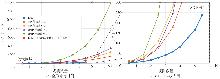
Fig. 10
Runtime comparison of the solution between LSC and the greedy collocation methods under different numbers of observations M"
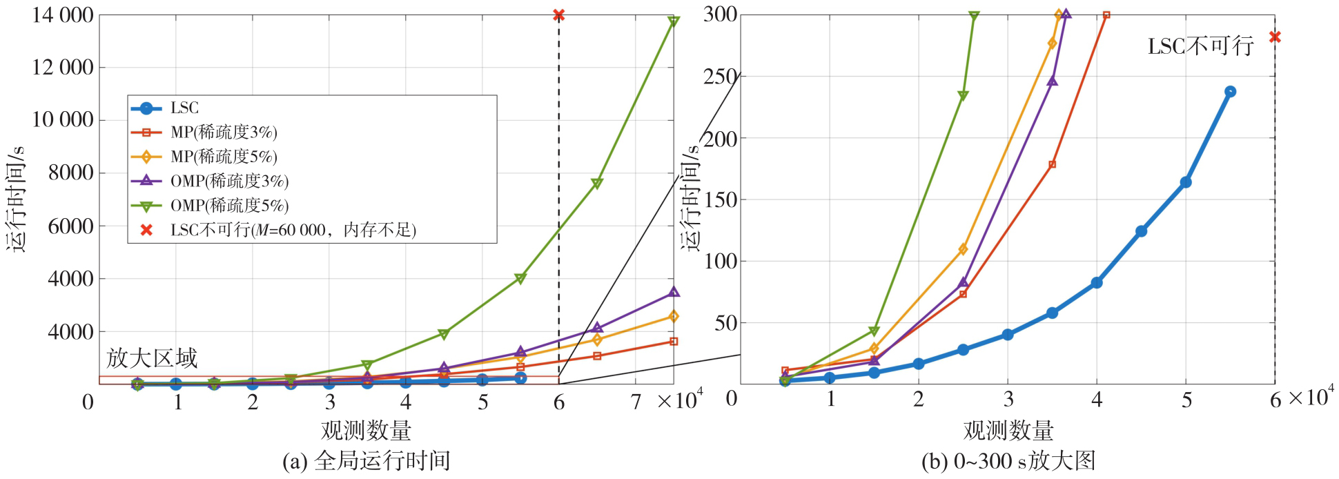
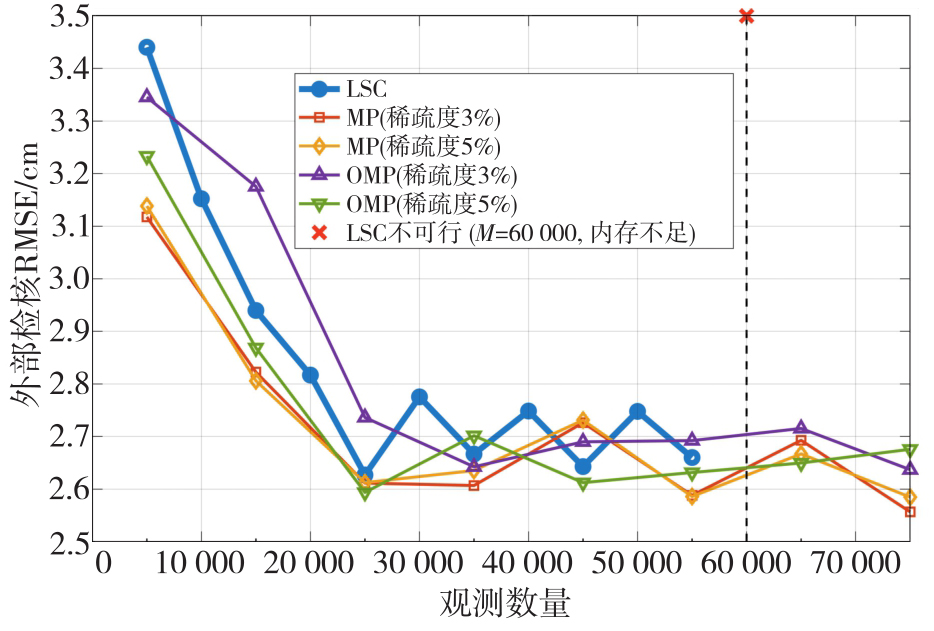
Fig. 11
Comparison of the external validation RMSE between LSC and the greedy collocation methods under different numbers of observations M"
Tab. 5
Mean ± STD of checkpoint geoid-difference STD for different algorithms under covariance mismatch and varying observation-noise levels under 50 repeated trials"
| 噪声STD | LSC(精确协方差) | LSC(经验协方差) | MP(3%) | MP(5%) | OMP(3%) | OMP(5%) |
|---|---|---|---|---|---|---|
| 1 mGal | 1.57±0.08 | 2.12±0.30 | 2.37±0.18 | 2.14±0.15 | 2.04±0.12 | 1.93±0.10 |
| 3 mGal | 2.23±0.12 | 2.95±0.40 | 2.59±0.22 | 2.30±0.18 | 2.20±0.13 | 2.06±0.12 |
| 5 mGal | 3.01±0.18 | 3.88±0.60 | 2.80±0.28 | 2.52±0.22 | 2.32±0.15 | 2.17±0.14 |
| [1] | HEISKANEN W A, MORITZ H. Physical geodesy[M]. San Francisco: W. H. Freeman, 1967. |
| [2] | 宁津生, 罗志才, 杨沾吉, 等. 深圳市1 km高分辨率厘米级高精度大地水准面的确定[J]. 测绘学报, 2003, 32(2): 102-107. |
| NING Jinsheng, LUO Zhicai, YANG Zhanji, et al. Determination of Shenzhen geoid with 1 km resolution and centimeter accuracy[J]. Acta Geodaetica et Cartographica Sinica, 2003, 32(2): 102-107. | |
| [3] |
李建成, 吴云龙, 姚宜斌, 等. 面向“数据-场景-模式”驱动的卫星重力技术研究进展、挑战与趋势[J]. 测绘学报, 2025, 54(9): 1537-1560. DOI: .
doi: 10.11947/j.AGCS.2025.20250274 |
|
LI Jiancheng, WU Yunlong, YAO Yibin, et al. Satellite gravity technology oriented towards data-scenario-model driven approach: developments, challenges and outlook[J]. Acta Geodaetica et Cartographica Sinica, 2025, 54(9): 1537-1560. DOI: .
doi: 10.11947/j.AGCS.2025.20250274 |
|
| [4] | 李建成. 最新中国陆地数字高程基准模型:重力似大地水准面CNGG2011[J]. 测绘学报, 2012, 41(5): 651-660, 669. |
| LI Jiancheng. The recent Chinese terrestrial digital height datum model: gravimetric quasi-geoid CNGG2011[J]. Acta Geodaetica et Cartographica Sinica, 2012, 41(5): 651-660, 669. | |
| [5] | 章传银, 郭春喜, 陈俊勇, 等. EGM 2008地球重力场模型在中国大陆适用性分析[J]. 测绘学报, 2009, 38(4): 283-289. |
| ZHANG Chuanyin, GUO Chunxi, CHEN Junyong, et al. EGM 2008 and its application analysis in Chinese mainland[J]. Acta Geodaetica et Cartographica Sinica, 2009, 38(4): 283-289. | |
| [6] | 孙文科. 低轨道人造卫星(CHAMP、GRACE、GOCE)与高精度地球重力场:卫星重力大地测量的最新发展及其对地球科学的重大影响[J]. 大地测量与地球动力学, 2002, 22(1): 92-100. |
| SUN Wenke. Satellite in low orbit (CHAMP, GRACE, GOCE) and high precision Earth gravity field: the latest progress of satellite gravity geodesy and its great influence on geoscience[J]. Journal of Geodesy and Geodynamics, 2002, 22(1): 92-100. | |
| [7] |
吴晓辉, 吴云龙, 徐国栋, 等. 一种顾及地理纬度空间互补的多域组合GRACE去条带滤波方法[J]. 测绘学报, 2024, 53(11): 2149-2165. DOI: .
doi: 10.11947/j.AGCS.2024.20240072 |
|
WU Xiaohui, WU Yunlong, XU Guodong, et al. A multi-domain combined GRACE de-striping filtering method taking in-to account spatial complementarity of geographic latitude[J]. Acta Geodaetica et Cartographica Sinica, 2024, 53(11): 2149-2165. DOI: .
doi: 10.11947/j.AGCS.2024.20240072 |
|
| [8] |
党亚民, 蒋涛, 杨元喜, 等. 中国大地测量研究进展(2019—2023)[J]. 测绘学报, 2023, 52(9): 1419-1436. DOI: .
doi: 10.11947/j.AGCS.2023.20230343 |
|
DANG Yamin, JIANG Tao, YANG Yuanxi, et al. Research progress of geodesy in China (2019—2023)[J]. Acta Geodaetica et Cartographica Sinica, 2023, 52(9): 1419-1436. DOI: .
doi: 10.11947/j.AGCS.2023.20230343 |
|
| [9] | 吴云龙, 李好, 张帆, 等. 西藏定日县Ms 6.8地震深部构造特征与孕震环境分析[J]. 武汉大学学报(信息科学版), 2025, 50(11): 2163-2175, 2186. |
| WU Yunlong, LI Hao, ZHANG Fan, et al. Analysis of deep tectonic characteristics and seismogenic environment of the Ms 6.8 earthquake in Dingri, Xizang, China[J]. Geomatics and Information Science of Wuhan University, 2025, 50(11): 2163-2175, 2186. | |
| [10] | 吴怿昊, 罗志才, 周波阳. 基于泊松小波径向基函数融合多源数据的局部重力场建模[J]. 地球物理学报, 2016, 59(3): 852-864. |
| WU Yihao, LUO Zhicai, ZHOU Boyang. Regional gravity modeling based on heterogeneous data sets by using Poisson wavelets radial basis functions[J]. Chinese Journal of Geophysics, 2016, 59(3): 852-864. | |
| [11] | 马志伟, 边少锋, 陆洋, 等. 融合多源重力数据构建局部高阶重力场模型[J]. 测绘科学, 2021, 46(6): 21-30. |
| MA Zhiwei, BIAN Shaofeng, LU Yang, et al. Regional high-degree gravity field modeling by combining multi-source gravity data[J]. Science of Surveying and Mapping, 2021, 46(6): 21-30. | |
| [12] | MORITZ H. Advanced physical geodesy[M]. Karlsruhe: Wichmann, 1980. |
| [13] | KRARUP T. A contribution to the mathematical foundation of physical geodesy[M]. Copenhagen: Geodesy Institute Copenhagen, 1969. |
| [14] | WANG Yanming, SÁNCHEZ L, ÅGREN J, et al. Colorado geoid computation experiment: overview and summary[J]. Journal of Geodesy, 2021, 95(12): 127. |
| [15] | ZINGERLE P, PAIL R, WILLBERG M, et al. A partition-enhanced least-squares collocation approach (PE-LSC)[J]. Journal of Geodesy, 2021, 95(8): 94. |
| [16] | SCHNEIDER N, MICHEL V. A dictionary learning add-on for spherical downward continuation[J]. Journal of Geodesy, 2022, 96(4): 21. |
| [17] | LIGAS M. Comparison of Kriging and least-squares collocation-revisited[J]. Journal of Applied Geodesy, 2022, 16(3): 217-227. |
| [18] | CHANG Guobin, BIAN Shaofeng. Least-squares collocation: a spherical harmonic representer theorem[J]. Geophysical Journal International, 2023, 234(2): 879-886. |
| [19] | MA Zhiwei. Gravity field modeling in mountainous areas based on band-limited SRBFs[J]. Journal of Geodesy, 2024, 98(5): 41. |
| [20] | DONOHO D L. For most large underdetermined systems of linear equations the minimal l1-norm solution is also the sparsest solution[J]. Communications on Pure and Applied Mathematics, 2006, 59(7): 797-829. |
| [21] | BAI Lanshu, LU Huiyi, LIU Yike. High-efficiency observations: compressive sensing and recovery of seismic waveform data[J]. Pure and Applied Geophysics, 2020, 177(1): 469-485. |
| [22] | 于会臻, 王金铎, 王千军. 基于密度模型稀疏表征的重力反演方法[J]. 地球物理学报, 2021, 64(3): 1061-1073. |
| YU Huizhen, WANG Jinduo, WANG Qianjun. Gravity inversion based on sparse representation of density model[J]. Chinese Journal of Geophysics, 2021, 64(3): 1061-1073. | |
| [23] | YU Haipeng, CHANG Guobin, ZHANG Shubi, et al. Application of sparse regularization in spherical radial basis functions-based regional geoid modeling in Colorado[J]. Remote Sensing, 2023, 15(19): 4870. |
| [24] | YU Haipeng, CHANG Guobin, ZHANG Shubi, et al. Sparsifying spherical radial basis functions based regional gravity models[J]. Journal of Spatial Science, 2022, 67(2): 297-312. |
| [25] | QIAN Nijia, CHANG Guobin, DITMAR P, et al. Sparse DDK: a data-driven decorrelation filter for GRACE level-2 products[J]. Remote Sensing, 2022, 14(12): 2810. |
| [26] | WU Xiaohui, WU Yunlong, XU Chuang, et al. A physically informed spatial filter for destriping GRACE time-variable gravity fields[J]. Geophysical Journal International, 2026, 245(1): ggag048. |
| [27] | MALLAT S G, ZHANG Zhifeng. Matching pursuits with time-frequency dictionaries[J]. IEEE Transactions on Signal Processing, 1993, 41(12): 3397-3415. |
| [28] | PATI Y C, REZAIIFAR R, KRISHNAPRASAD P S. Orthogonal matching pursuit: recursive function approximation with applications to wavelet decomposition[C]//Proceedings of 2002 Asilomar Conference on Signals, Systems and Computers. Pacific Grove: IEEE, 2002: 40-44. |
| [29] | TSCHERNING C C, RAPP R H. Closed covariance expressions for gravity anomalies, geoid undulations, and deflections of the vertical implied by anomaly degree variance models[R]. Columbus: Ohio State University, 1974. |
| [30] | KAULA W M. Theory of satellite geodesy: applications of satellites to geodesy[M]. London: Blaisdell Publishing Company, 1966. |
| [31] | VAN WESTRUM D, AHLGREN K, HIRT C, et al. A geoid slope validation survey (2017) in the rugged terrain of Colorado, USA[J]. Journal of Geodesy, 2021, 95(1): 9. |
| [32] | ZINGERLE P, PAIL R, GRUBER T, et al. The combined global gravity field model XGM2019e[J]. Journal of Geodesy, 2020, 94(7): 66. |
| [33] | PAVLIS N K, HOLMES S A, KENYON S C, et al. The development and evaluation of the Earth gravitational model 2008(EGM2008)[J]. Journal of Geophysical Research: Solid Earth, 2012, 117(B4): 2011JB008916. |
| [34] | HIRT C, KUHN M, CLAESSENS S, et al. Study of the Earth's short-scale gravity field using the ERTM2160 gravity model[J]. Computers & Geosciences, 2014, 73: 71-80. |
| [35] | MA Zhiwei, YANG Meng, LIU Jie. Regional gravity field modeling using band-limited SRBFs: a case study in Colorado[J]. Remote Sensing, 2023, 15(18): 4515. |
| [36] | 章传银, 丁剑, 晁定波. 局部重力场最小二乘配置通用表示技术[J]. 武汉大学学报(信息科学版), 2007, 32(5): 431-434. |
| ZHANG Chuanyin, DING Jian, CHAO Dingbo. General expression of least squares collocation in local gravity field[J]. Geomatics and Information Science of Wuhan University, 2007, 32(5): 431-434. | |
| [37] | KNUDSEN. Estimation and modelling of the local empirical covariance function using gravity and satellite altimeter data[J]. Bulletin Géodésique, 1987, 61(2): 145-160. |
| [1] | Chuanyin ZHANG, Tao JIANG, Baogui KE. Theoretical foundation of gravity field and improvement of classical concepts for geodetic height datum unified in the terrestrial reference system [J]. Acta Geodaetica et Cartographica Sinica, 2025, 54(9): 1561-1571. |
| [2] | Hailu CHEN, Yunzhong SHEN. GNSS-assisted InSAR tropospheric delay correction model incorporating vertical stratification and turbulent components [J]. Acta Geodaetica et Cartographica Sinica, 2025, 54(10): 1786-1797. |
| [3] | SONG Shangzhen, YANG Yixin, WANG Huifeng, WANG Xiaoyan, RONG Shenghui, ZHOU Huixin. Hyperspectral anomaly detection combining sparse constraint and feature extraction via stacked autoencoder [J]. Acta Geodaetica et Cartographica Sinica, 2023, 52(6): 932-943. |
| [4] | JIANG Tao, DANG Yamin, GUO Chunxi, CHEN Bin, ZHANG Chuanyin. Realization of the international height reference system in the region of Mount Qomolangma [J]. Acta Geodaetica et Cartographica Sinica, 2022, 51(8): 1757-1767. |
| [5] | WEI Ziqing. Introduction to the second geodetic boundary value problem [J]. Acta Geodaetica et Cartographica Sinica, 2022, 51(6): 797-803. |
| [6] | HONG Liang, FENG Yafei, PENG Shuangyun, CHU Sensen. Classification of high spatial resolution remote sensing imagery based on object-oriented multi-scale weighted sparse representation [J]. Acta Geodaetica et Cartographica Sinica, 2022, 51(2): 224-237. |
| [7] | HUANG Motao, DENG Kailiang, WU Taiqi, WANG Weiping, OUYANG Yongzhong, CHEN Xin, WANG Xu. A two-step integral method for geoid determination using generalized band-limited airborne vector gravity data [J]. Acta Geodaetica et Cartographica Sinica, 2022, 51(11): 2245-2254. |
| [8] | DANG Yamin, GUO Chunxi, JIANG Tao, ZHANG Qingtao, CHEN Bin, JIANG Guangwei. 2020 height measurement and determination of Mount Qomolangma [J]. Acta Geodaetica et Cartographica Sinica, 2021, 50(4): 556-561. |
| [9] | MA Jian, WEI Ziqing, REN Hongfei. Hotine-Helmert boundary-value calculation model for quasi-geoid determination [J]. Acta Geodaetica et Cartographica Sinica, 2019, 48(2): 153-160. |
| [10] | XING Zhibin, LI Shanshan. The 3D Gravity Vectors Method in China Land and Ocean Quasi-geoid Determination [J]. Acta Geodaetica et Cartographica Sinica, 2018, 47(5): 575-583. |
| [11] | XU Houze. Global Unification Problem of the Height System [J]. Acta Geodaetica et Cartographica Sinica, 2017, 46(8): 939-944. |
| [12] | WANG Zhongmei, YANG Xiaomei, GU Xingfa. Hyperspectral Image Denoising Based on Tensor Group Sparse Representation [J]. Acta Geodaetica et Cartographica Sinica, 2017, 46(5): 614-622. |
| [13] | LU Wanyun, WANG Jizhou, CAO Meng. Cloud Removal in ZY-3 Remote Sensing Image Based on Atoms-reordered Dictionary Learning AO-DL [J]. Acta Geodaetica et Cartographica Sinica, 2017, 46(5): 623-630. |
| [14] | WANG Leyang, CHEN Hanqing. Multi-beam Bathymetry Data Processing Using Iterative Algorithm of Robust Least Squares Collocation [J]. Acta Geodaetica et Cartographica Sinica, 2017, 46(5): 658-665. |
| [15] | MA Zhiwei, LU Yang, TU Yi, ZHU Chuandong, XI Hui. Regional Gravity Field Modeling with Abel-Poisson Radial Basis Functions [J]. Acta Geodaetica et Cartographica Sinica, 2016, 45(9): 1019-1027. |
| Viewed | ||||||
|
Full text |
|
|||||
|
Abstract |
|
|||||