


测绘学报 ›› 2025, Vol. 54 ›› Issue (7): 1318-1331.doi: 10.11947/j.AGCS.2025.20240490
孟妮娜1( ), 李凤梅1, 周校东2
收稿日期:2024-12-04
修回日期:2025-06-16
出版日期:2025-08-18
发布日期:2025-08-18
作者简介:孟妮娜(1978—),女,博士,副教授,研究方向为地图制图、GIS深度学习。E-mail:mengnina@chd.edu.cn
基金资助:
Nina MENG1(), Fengmei LI1, Xiaodong ZHOU2
Received:2024-12-04
Revised:2025-06-16
Online:2025-08-18
Published:2025-08-18
About author:MENG Nina (1978—), female, PhD, associate professor, majors in cartography and deep learning in GIS. E-mail: mengnina@chd.edu.cn
Supported by:摘要:
制图综合结果与综合尺度的一致性是制图综合结果质量评价的重要内容。评价过程涉及数量特征、结构特征、认知特征等多维度因素。传统方法在多种指标组合评价时存在量化指标难以确定的问题,且不易融合空间认知等领域知识。基于此,本文提出一种基于空域图卷积神经网络的建筑物群制图综合结果与尺度一致性的识别模型。该模型采用数据驱动与认知驱动相结合的策略,从整体结构、局部结构和个体特征3个空间认知层次度量建筑物群综合前后的特征变化,并利用多尺度综合成果数据进行训练。试验结果表明,本文模型能有效识别制图综合结果与目标尺度的一致性。
中图分类号:
孟妮娜, 李凤梅, 周校东. 数据与认知双驱动的建筑物群制图综合结果与尺度一致性识别[J]. 测绘学报, 2025, 54(7): 1318-1331.
Nina MENG, Fengmei LI, Xiaodong ZHOU. Data and cognition dual-driven building group generalization results and scale consistency assessment[J]. Acta Geodaetica et Cartographica Sinica, 2025, 54(7): 1318-1331.

图1
建筑物群的中线长和相邻中线夹角"

表1
建筑物群的特征描述及计算"
| 分类 | 特征名称 | 度量方法 | 形式化表示或计算公式 | 说明 |
|---|---|---|---|---|
| 个体特征 | 形状 | 紧密度 | Tig(m)=4πArea(m)/P2(m) | Area(m)和P(m)分别为建筑物m的面积和周长 |
| 尺寸 | 建筑物面积 | Area(m) | ||
| 位置 | 建筑物几何中心 |  | P(xi,yi)为建筑物顶点坐标 | |
| 局部特征 | 方向 | 建筑物最小外接矩形的最长边与x轴正轴之间的夹角 | Direct(m)=Angle(SMBR(m),x) | SMBR(m)为建筑物最小外接矩形的最长边 |
| 方向关系 | 相邻建筑物的Voronoi方向关系 | Dir_voronoi(mi,mj) | mi、mj表示相邻的两个建筑物 | |
| 距离关系 | 相邻建筑物的邻近距离 | Distance(mi,mj) | ||
| 中线长 | 邻近建筑物形心连线中点与建筑物群中心的距离 | L(mi,mj) | ||
| 中线夹角 | 两个相邻中线构成的夹角 | α(Lp,Lq) | Lp、Lq为相邻的中线 | |
| 群轮廓 | 建筑物群凸壳的面积 | Area(group) | V(xi,yi)为建筑物群凸壳的顶点 | |
| 群中心 | 建筑物群凸壳的几何中心 |  | ||
| 整体特征 | 群平均面积 | 建筑物群的平均面积 |  | mi表示群内的每个建筑物,n表示建筑物数量 |
| 群平均周长 | 建筑物群的平均周长 |  | ||
| 群密度 | 群内建筑物数量与群凸壳面积的比值 | Density(group)=n/Area(group) |
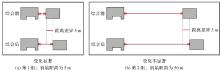
图2
初始距离对距离关系相似性判断的影响"


图3
空间关系相似性判断认知试验的问卷实例注:请观察场景A和场景B,并根据您的认知对A、B两个场景的整体相似程度进行打分,1分表示非常不相似,2分表示不相似,3分表示中立,4分表示相似,5分表示非常相似。"

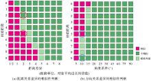
图4
不同初始距离下距离关系差异和方向关系差异的相似性判断"

表2
制图综合前后建筑物群变化特征的度量"
| 分类 | 特征名称 | 表示 | 计算公式 | 说明 |
|---|---|---|---|---|
| 个体变化特征 | 形状变化 | Cs | Cs=|Tig(V)-Tig(O)| | V表示综合后的建筑物,O表示综合前的建筑物 |
| 尺寸变化 | Ca | Ca=|Area(V)-Area(O)| | ||
| 位置变化 | Cp | Cp=|Loacat(V)-Loacat(O)| | ||
| 方向变化 | Cd | Cd=|Dierct(V)-Direct(O)|,Cd∈[0°,180°] | ||
| 局部变化特征 | 方向关系变化 | Lv | Lv=|Dir_voronoi(Vi,Vj)-Dir_voronoi(Oi,Oj)|,Lv∈[0°,180°] | Vi、Vj表示综合后相邻的建筑物,Oi、Oj表示综合前相邻的建筑物 |
| 距离关系变化 | Ld | Ld=|Distance(Vi,Vj)-Distance(Oi,Oj)| | ||
| 初始距离 | Lo | Distance(Oi,Oj) | VLp、VLq表示综合后相邻的中线,OLp、OLq表示综合前相邻的中线 | |
| 中线长变化 | Ll | Ll=|L(Vi,Vj)-L(Oi,Oj)| | ||
| 相邻中线夹角变化 | Lα | Lα=|α(VLp,VLq)-α(OLp,OLq)| | ||
| 整体变化特征 | 群轮廓变化 | Gl | Gl=|Area(groupv)-Area(groupO)| | groupv表示综合后的建筑物群组,groupO表示综合前的建筑物群组 |
| 群中心变化 | Gc | Gc=|Center(groupv)-Center(groupO)| | ||
| 群平均面积变化 | Ga | Ga=|Area_mean(groupv)-Area_mean(groupO)| | ||
| 群平均周长变化 | Gp | Gp=|Perim_mean(groupv)-Perim_mean(groupO)| | ||
| 群分布密度变化 | Gd | Gd=|Density(groupv)-Density(groupO)| |
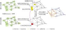
图5
综合前后建筑物群的关系叠加操作"

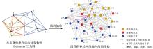
图6
图卷积神经网络的图结构构建"

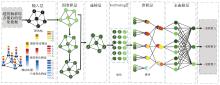
图7
建筑物群综合结果与尺度一致性判断的DGCNN模型"

表3
试验环境配置"
| 名称 | 配置信息 |
|---|---|
| 操作系统 | Ubuntu 20.04子系统、Windows 11系统 |
| 开发语言 | Python 3.8.10 |
| 框架 | Py Torch 1.13.1 |
| GPU | NVIDIA GeForce GTX 1050Ti |
| CPU | AMD Ryzen 5 2600 |
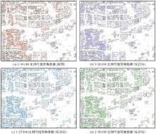
图8
试验数据"

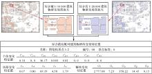
图9
综合前后建筑物群变化特征值计算样例"

表4
建筑物群匹配对的编码方式"
| 建筑物群匹配对的类型 | One-hot编码 | |
|---|---|---|
| 综合前 | 综合后 | |
| 1∶10 000 | 1∶20 000 | [1,0,0] |
| 1∶10 000 | 1∶25 000 | [0,1,0] |
| 1∶10 000 | 1∶30 000 | [0,0,1] |
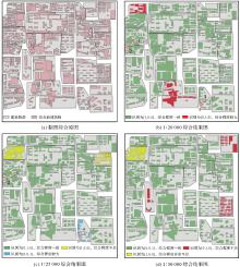
图10
部分不同比例尺建筑群的预测结果"


图11
模型的准确度变化"
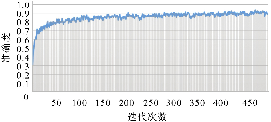

图12
模型的损失值变化"

表5
模型分类的混淆矩阵"
| 测试集样本 | 预测:[1,0,0] | 预测:[0,1,0] | 预测:[0,0,1] |
|---|---|---|---|
| 标签:[1,0,0] | 65 | 3 | 4 |
| 标签:[0,1,0] | 4 | 65 | 2 |
| 标签:[0,0,1] | 5 | 4 | 57 |
表6
模型分类的指标评价"
| 指标 | 标签:[1,0,0] | 标签:[0,1,0] | 标签:[0,0,1] | 宏平均 |
|---|---|---|---|---|
| 精确率 | 0.878 3 | 0.902 7 | 0.904 7 | 0.895 3 |
| 召回率 | 0.902 7 | 0.915 4 | 0.863 6 | 0.893 9 |
| F1值 | 0.890 4 | 0.909 0 | 0.883 7 | 0.894 4 |
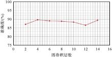
图13
不同图卷积层数对模型准确度的影响"

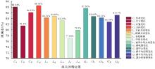
图14
缺失不同特征值对模型准确度的影响"

| [1] | 李志林, 王继成, 谭诗腾, 等. 地理信息科学中尺度问题的30年研究现状[J]. 武汉大学学报(信息科学版), 2018, 43(12): 2233-2242. |
| LI Zhilin, WANG Jicheng, TAN Shiteng, et al. Scale in geo-information science: an overview of thirty-year development[J]. Geomatics and Information Science of Wuhan University, 2018, 43(12): 2233-2242. | |
| [2] |
艾廷华. 深度学习赋能地图制图的若干思考[J]. 测绘学报, 2021, 50(9): 1170-1182. DOI: .
doi: 10.11947/j.AGCS.2021.20210091 |
|
AI Tinghua. Some thoughts on deep learning enabling cartography[J]. Acta Geodaetica et Cartographica Sinica, 2021, 50(9): 1170-1182. DOI: .
doi: 10.11947/j.AGCS.2021.20210091 |
|
| [3] | KNURA M. Learning from vector data: enhancing vector-based shape encoding and shape classification for map generalization purposes[J]. Cartography and Geographic Information Science, 2024, 51(1): 146-167. |
| [4] | GAO Aji, AI Tinghua, YU Huafei, et al. A vector-based coastline shape classification approach using sequential deep learning model[J]. International Journal of Applied Earth Observation and Geoinformation, 2024, 129: 103810. |
| [5] | YAN Xiongfeng, AI Tinghua, YANG Min, et al. Graph convolutional autoencoder model for the shape coding and cognition of buildings in maps[J]. International Journal of Geographical Information Science, 2021, 35(3): 490-512. |
| [6] |
于洋洋, 贺康杰, 武芳, 等. 面状居民地形状分类的图卷积神经网络方法[J]. 测绘学报, 2022, 51(11): 2390-2402. DOI: .
doi: 10.11947/j.AGCS.2022.20210134 |
|
YU Yangyang, HE Kangjie, WU Fang, et al. Graph convolution neural network method for shape classification of areal settlements[J]. Acta Geodaetica et Cartographica Sinica, 2022, 51(11): 2390-2402. DOI: .
doi: 10.11947/j.AGCS.2022.20210134 |
|
| [7] | YU Huafei, AI Tinghua, YANG Min, et al. A recognition method for drainage patterns using a graph convolutional network[J]. International Journal of Applied Earth Observation and Geoinformation, 2022, 107: 102696. |
| [8] | WANG Wenning, YAN Haowen, LU Xiaomin, et al. Drainage pattern recognition method considering local basin shape based on graph neural network[J]. International Journal of Digital Earth, 2023, 16(1): 593-619. |
| [9] | DONADIO C, BRESCIA M, RICCARDO A, et al. A novel approach to the classification of terrestrial drainage networks based on deep learning and preliminary results on solar system bodies[J]. Scientific Reports, 2021, 11(1): 5875. |
| [10] | YAN Xiongfeng, AI Tinghua, YANG Min, et al. A graph convolutional neural network for classification of building patterns using spatial vector data[J]. ISPRS Journal of Photogrammetry and Remote Sensing, 2019, 150: 259-273. |
| [11] | 孟妮娜, 王安东, 周校东. 建筑物线型排列模式识别的图卷积神经网络方法[J]. 测绘科学技术学报, 2019, 36(6): 627-631. |
| MENG Nina, WANG Andong, ZHOU Xiaodong. A graph convolutional neural network method for pattern recognition of linear building alignment[J]. Journal of Geomatics Science and Technology, 2019, 36(6): 627-631. | |
| [12] | 王米琪, 艾廷华, 晏雄锋, 等. 图卷积网络模型识别道路正交网格模式[J]. 武汉大学学报(信息科学版), 2020, 45(12): 1960-1969. |
| WANG Miqi, AI Tinghua, YAN Xiongfeng, et al. Grid pattern recognition in road networks based on graph convolution network model[J]. Geomatics and Information Science of Wuhan University, 2020, 45(12): 1960-1969. | |
| [13] | YANG Min, JIANG Chenjun, YAN Xiongfeng, et al. Detecting interchanges in road networks using a graph convolutional network approach[J]. International Journal of Geographical Information Science, 2022, 36(6): 1119-1139. |
| [14] | LI Chengming, ZHANG Honggang, WU Pengda, et al. A complex junction recognition method based on GoogLeNet model[J]. Transactions in GIS, 2020, 24(6): 1756-1778. |
| [15] |
肖天元, 艾廷华, 余华飞, 等. 地图综合图卷积神经网络点群简化方法[J]. 测绘学报, 2024, 53(1): 158-172. DOI: .
doi: 10.11947/j.AGCS.2024.20220584 |
|
XIAO Tianyuan, AI Tinghua, YU Huafei, et al. A point cluster simplification approach of graph convolutional neural network for map generalization[J]. Acta Geodaetica et Cartographica Sinica, 2024, 53(1): 158-172. DOI: .
doi: 10.11947/j.AGCS.2024.20220584 |
|
| [16] | YU Huafei, AI Tinghua, YANG Min, et al. Integrating domain knowledge and graph convolutional neural networks to support river network selection[J]. Transactions in GIS, 2023, 27(7): 1898-1927. |
| [17] | COURTIAL A, TOUYA G, ZHANG Xiang. Deriving map images of generalised mountain roads with generative adversarial networks[J]. International Journal of Geographical Information Science, 2023, 37(3): 499-528. |
| [18] | COURTIAL A, EL AYEDI A, TOUYA G, et al. Exploring the potential of deep learning segmentation for mountain roads generalisation[J]. ISPRS International Journal of Geo-Information, 2020, 9(5): 338. |
| [19] | KARSZNIA I, ADOLF A, LEYK S, et al. Using machine learning and data enrichment in the selection of roads for small-scale maps[J]. Cartography and Geographic Information Science, 2024, 51(1): 60-78. |
| [20] | LEE J, JANG H, YANG J, et al. Machine learning classification of buildings for map generalization[J]. ISPRS International Journal of Geo-Information, 2017, 6(10): 309. |
| [21] | COURTIAL A, TOUYA G, ZHANG X. Generative adversarial networks to generalise urban areas in topographic maps[J]. ISPRS-International Archives of the Photogrammetry, Remote Sensing and Spatial Information Sciences, 2021, 43B4: 15-22. |
| [22] |
武芳, 巩现勇, 杜佳威. 地图制图综合回顾与前望[J]. 测绘学报, 2017, 46(10): 1645-1664. DOI: .
doi: 10.11947/j.AGCS.2017.20170287 |
|
WU Fang, GONG Xianyong, DU Jiawei. Overview of the research progress in automated map generalization[J]. Acta Geodaetica et Cartographica Sinica, 2017, 46(10): 1645-1664. DOI: .
doi: 10.11947/j.AGCS.2017.20170287 |
|
| [23] | TOUYA G. Social welfare to assess the global legibility of a generalized map[C]//Proceedings of 2012 Geographic Information Science. Berlin: Springer, 2012: 198-211. |
| [24] | 邓红艳, 武芳, 翟仁健, 等. 基于多维约束空间的自动制图综合质量评估模型[J]. 中国矿业大学学报, 2006, 35(5): 667-672. |
| DENG Hongyan, WU Fang, ZHAI Renjian, et al. Quality evaluation model of automated cartographical generalization based on a multi-dimensional constraint space[J]. Journal of China University of Mining & Technology, 2006, 35(5): 667-672. | |
| [25] | STOTER J, BURGHARDT D, DUCHÊNE C, et al. Methodology for evaluating automated map generalization in commercial software[J]. Computers, Environment and Urban Systems, 2009, 33(5): 311-324. |
| [26] | COURTIAL A, TOUYA G, ZHANG X. Constraint-based evaluation of map images generalized by deep learning[J]. Journal of Geovisualization and Spatial Analysis, 2022, 6(1): 13. |
| [27] | FAN Hongchao, MENG Liqiu, CHENG Tao. Special issue on the recent trends of GeoAI techniques for SDGs[J]. Journal of Geodesy and Geoinformation Science, 2024, 7(1): 2. |
| [28] | YANG Min, YUAN Tuo, YAN Xiongfeng, et al. A hybrid approach to building simplification with an evaluator from a backpropagation neural network[J]. International Journal of Geographical Information Science, 2022, 36(2): 280-309. |
| [29] | RUAS A, HOLZAPFEL F. Automatic characterisation of building alignments by means of expert knowledge[C]//Proceedings of the 21st International Cartographic Conference (ICC). Durban: IEEE, 2003: 1604-1616. |
| [30] | MACEACHREN A M. Compactness of geographic shape: comparison and evaluation of measures[J]. Geografiska Annaler: Series B, Human Geography, 1985, 67(1): 53-67. |
| [31] | YAN Haowen, WEIBEL R. An algorithm for point cluster generalization based on the Voronoi diagram[J]. Computers & Geosciences, 2008, 34(8): 939-954. |
| [32] | ZHANG Xiang, AI Tinghua, STOTER J, et al. Building pattern recognition in topographic data: examples on collinear and curvilinear alignments[J]. GeoInformatica, 2013, 17(1): 1-33. |
| [33] | BORING E G. A history of experimental psychology[M]. New York: Appleton-Century-Crofts, 1950, 1: 284-290. |
| [34] | GESCHEIDER G A. Psychophysics: the fundamentals[M]. Mahwah: Lawrence Erlbaum Associates, 1997, 10: 53-58. |
| [35] | MONTELLO D R. Cognitive map-design research in the twentieth century[J]. Cartography and Geographic Information Science, 2002, 29(3), 283-304. |
| [36] | ZHANG Muhan, CUI Zhicheng, NEUMANN M, et al. An end-to-end deep learning architecture for graph classification[J]. Proceedings of the AAAI Conference on Artificial Intelligence, 2018, 544: 4438-4445. |
| [1] | 王家耀, 陈琳, 程士源, 王利军, 熊思奇. 人工智能赋能地图科学数智化[J]. 测绘学报, 2026, 55(3): 381-389. |
| [2] | 禄小敏, 张志义, 闫浩文, 何毅, 苏小宁. 融合深度图信息最大化和多层感知机的建筑物群组模式识别方法[J]. 测绘学报, 2026, 55(3): 425-438. |
| [3] | 贺彪, 林浩嘉, 郭仁忠, 蒯希, 马丁, 张琛. 基于视觉感知的三维空间相似关系量化计算[J]. 测绘学报, 2026, 55(1): 138-153. |
| [4] | 季顺平, 刘瑾, 高建, 龚健雅. 多视影像深度学习密集匹配三维重建智能框架[J]. 测绘学报, 2025, 54(9): 1633-1646. |
| [5] | 张继贤, 顾海燕, 倪欢, 李海涛, 杨懿, 丁少鹏, 隋淞蔓. 遥感智能变化检测的深度学习方法:演变与发展趋势[J]. 测绘学报, 2025, 54(8): 1347-1370. |
| [6] | 方帅, 刘加恩, 张晶. 自适应参考特征引入与多尺度特征聚合的时空融合算法[J]. 测绘学报, 2025, 54(8): 1476-1488. |
| [7] | 王亚青, 王中辉. 异构图卷积网络支持下的河系自动选取方法[J]. 测绘学报, 2025, 54(7): 1332-1345. |
| [8] | 安晓亚, 郭伟茹, 张鹏鑫, 李欣欣, 石磊. 顾及几何位置和移动特征相似性的船舶轨迹聚类方法[J]. 测绘学报, 2025, 54(6): 1107-1121. |
| [9] | 王超, 陈天宇, 张同, AhmedTanvir, 纪立强, 谢涛, 杨佳俊, 王帅. 基于全局差分增强模块和平衡惩罚损失的多源光学遥感影像变化检测[J]. 测绘学报, 2025, 54(5): 873-887. |
| [10] | 罗卿莉, 李雪岩, 黄国满, 陈红辉, 薛铭龙, 李健. AOSN:α-最优网络模型的山区单通道SAR高程重建方法[J]. 测绘学报, 2025, 54(5): 888-898. |
| [11] | 苏友能, 徐青, 孙群, 朱新铭, 张付兵, 刘波. 邻近边约束下的建筑物自动合并方法[J]. 测绘学报, 2025, 54(3): 563-576. |
| [12] | 涂伟, 池向沅, 赵天鸿, 杨剑, 朱世平, 陈德莉. 城市排水管网流量预测多视图时空图神经网络模型[J]. 测绘学报, 2025, 54(2): 334-344. |
| [13] | 张志力, 姜慧伟, 胡翔云. 面向极简交互的遥感地物精确批量提取框架[J]. 测绘学报, 2025, 54(10): 1863-1876. |
| [14] | 张正华, 陈国良. 一种轻量且旋转不变的激光雷达位置识别网络[J]. 测绘学报, 2025, 54(1): 90-103. |
| [15] | 石岩, 王达, 邓敏, 杨学习. 时空异常探测:从数据驱动到知识驱动的内涵转变与实现路径[J]. 测绘学报, 2024, 53(8): 1493-1504. |
| 阅读次数 | ||||||
|
全文 |
|
|||||
|
摘要 |
|
|||||