
Acta Geodaetica et Cartographica Sinica ›› 2026, Vol. 55 ›› Issue (9): 1555-1566.doi: 10.11947/j.AGCS.2026.20250550
• Geodesy and Navigation • Previous Articles Next Articles
Haili Sun1,2( ), Xinwu Yan1,2, Ping Yang1,2, Sheng Hai1,2, Ruofei Zhong1,2, Mingquan Wang3
Received:2025-12-30
Revised:2026-09-01
Online:2026-10-28
Published:2026-10-28
About author:Sun Haili (1986—), female, PhD, associate professor, majors in surveying and rail transit monitoring. E-mail: sunhaili@cnu.edu.cn
Supported by:CLC Number:
Haili Sun, Xinwu Yan, Ping Yang, Sheng Hai, Ruofei Zhong, Mingquan Wang. A staged tunnel registration method integrating dynamic pooling-based adaptive registration and neighborhood feature-assisted DTW[J]. Acta Geodaetica et Cartographica Sinica, 2026, 55(9): 1555-1566.
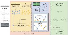
Fig. 1
Technical roadmap"

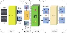
Fig. 2
Overall framework of the dynamic pooling adaptive registration method"

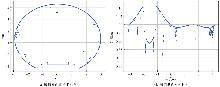
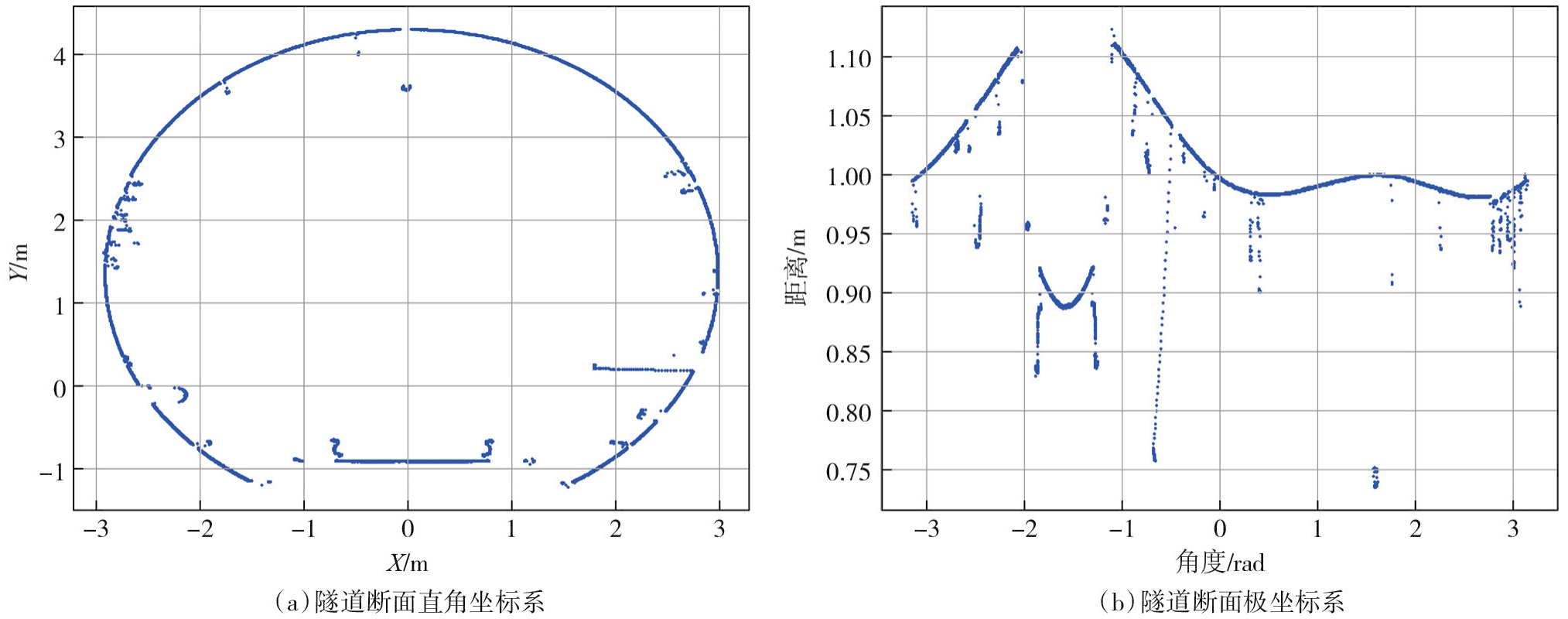
Fig. 3
Characteristics of tunnel sections in different coordinate systems"
Tab. 1
Overview of experimental data"
| 隧道类型 | 里程范围/m | 第一期采集时间 | 第二期采集时间 | 文件数 | 数据总量 |
|---|---|---|---|---|---|
| 盾构法 | 47 779.0~48 229.0 | 2022-09 | 2023-05 | 26 | 11.6×10⁹ |
| 矿山法 | 0.0~200.0 | 2022-08 | 2023-08 | 16 | 6.74×10⁹ |
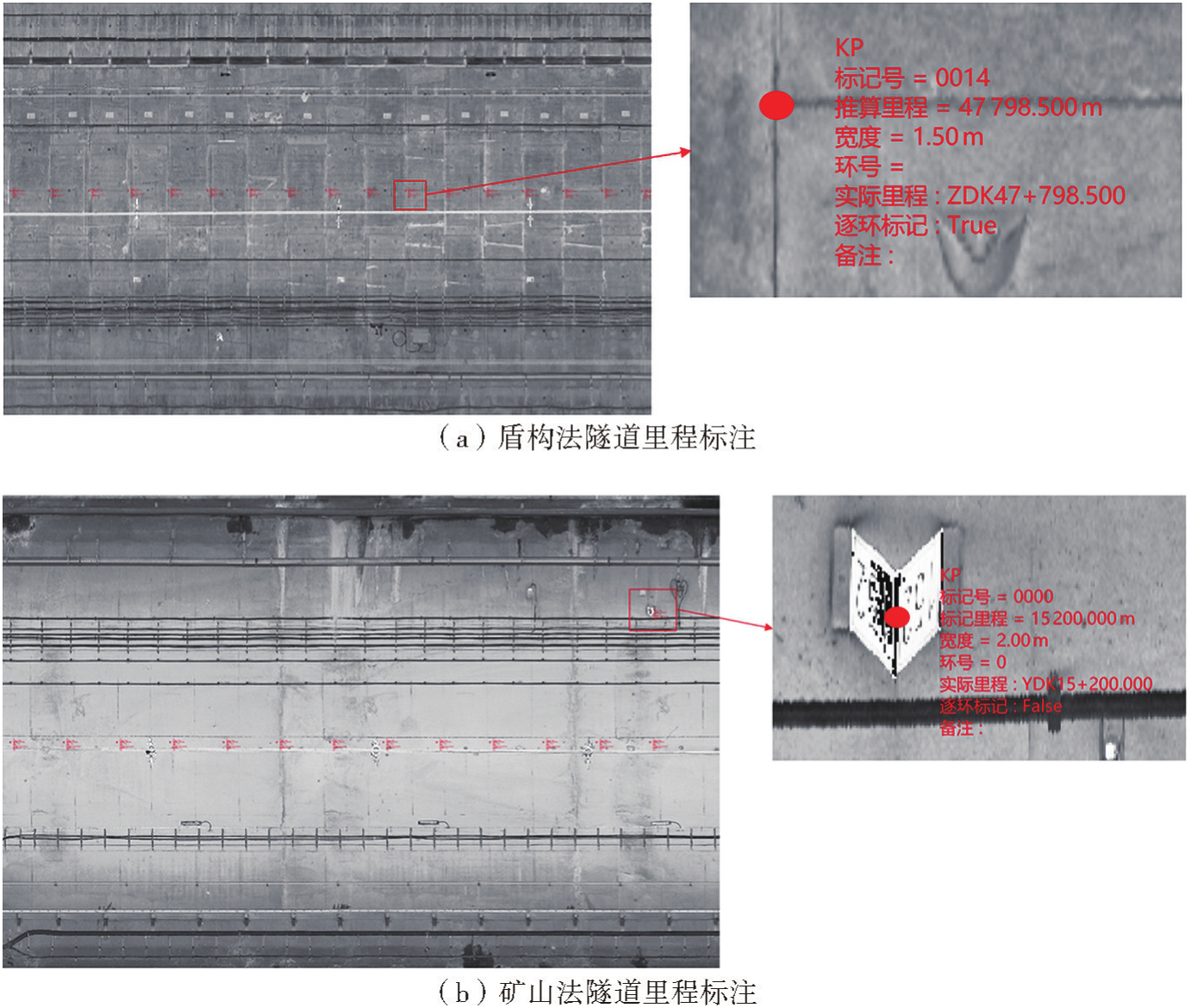
Fig. 4
Mileage marking of shield tunnel and mining tunnel"
Tab. 2
Registration results of different methods"
| 隧道数据 | 影像匹配方法 | 第一阶段影像配准误差 | 第二阶段点云配准误差 | 点云配准优化误差 | 点云配准前/后倒角距离 |
|---|---|---|---|---|---|
| 盾构法 | LightGlue | 1.0 | 0.9 | 0.1 | 2.4/0.2 |
| 动态池化自适应配准 | 1.3 | 1.2 | 0.1 | 1.8/0.3 | |
| 矿山法 | LightGlue | 3.6 | 3.0 | 0.6 | 2.3/0.1 |
| 动态池化自适应配准 | 3.7 | 3.6 | 0.1 | 0.3/0.2 |
Fig. 5
Section registration effect diagram"
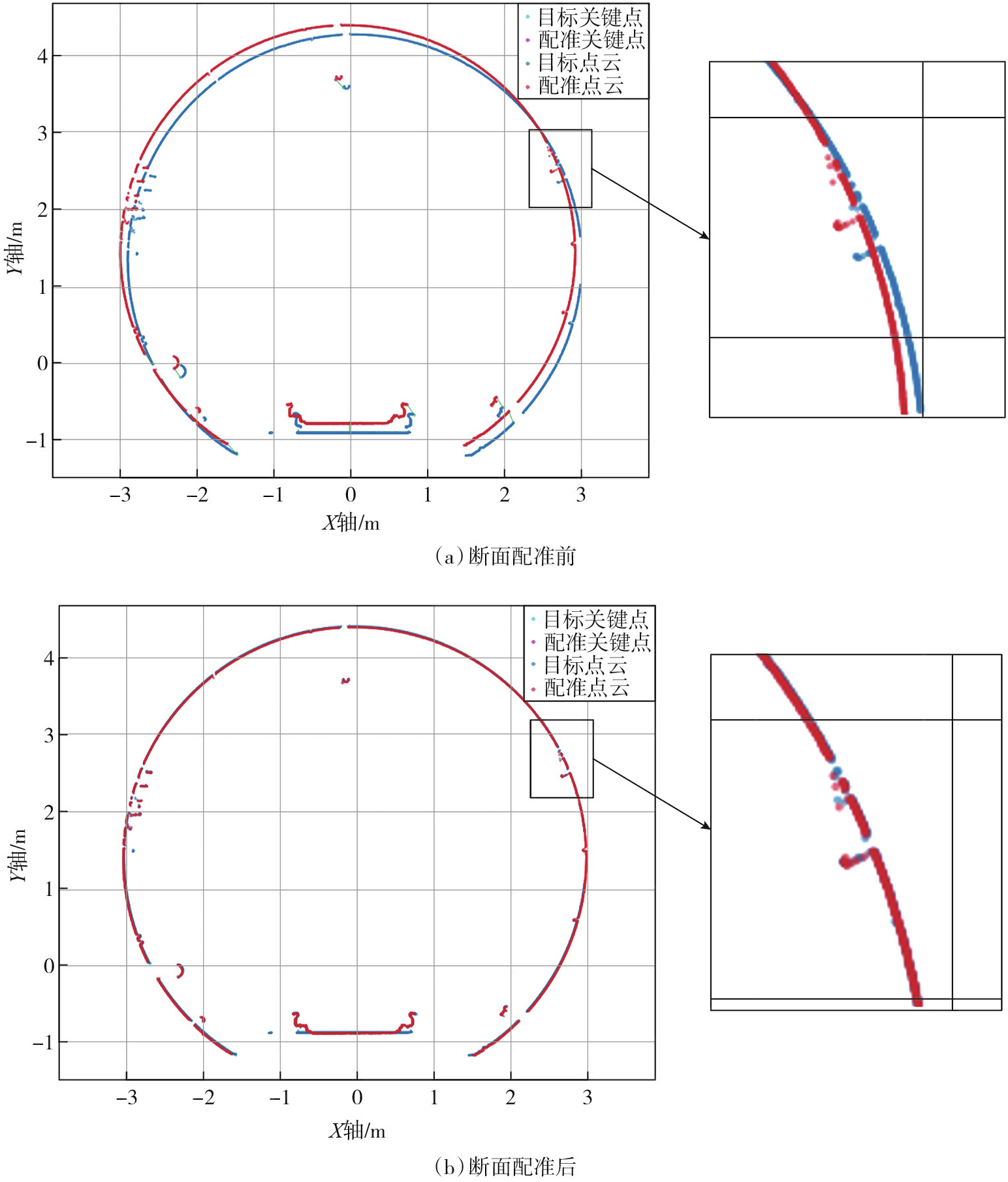
Fig. 6
Shield tunnel and mining tunnel"
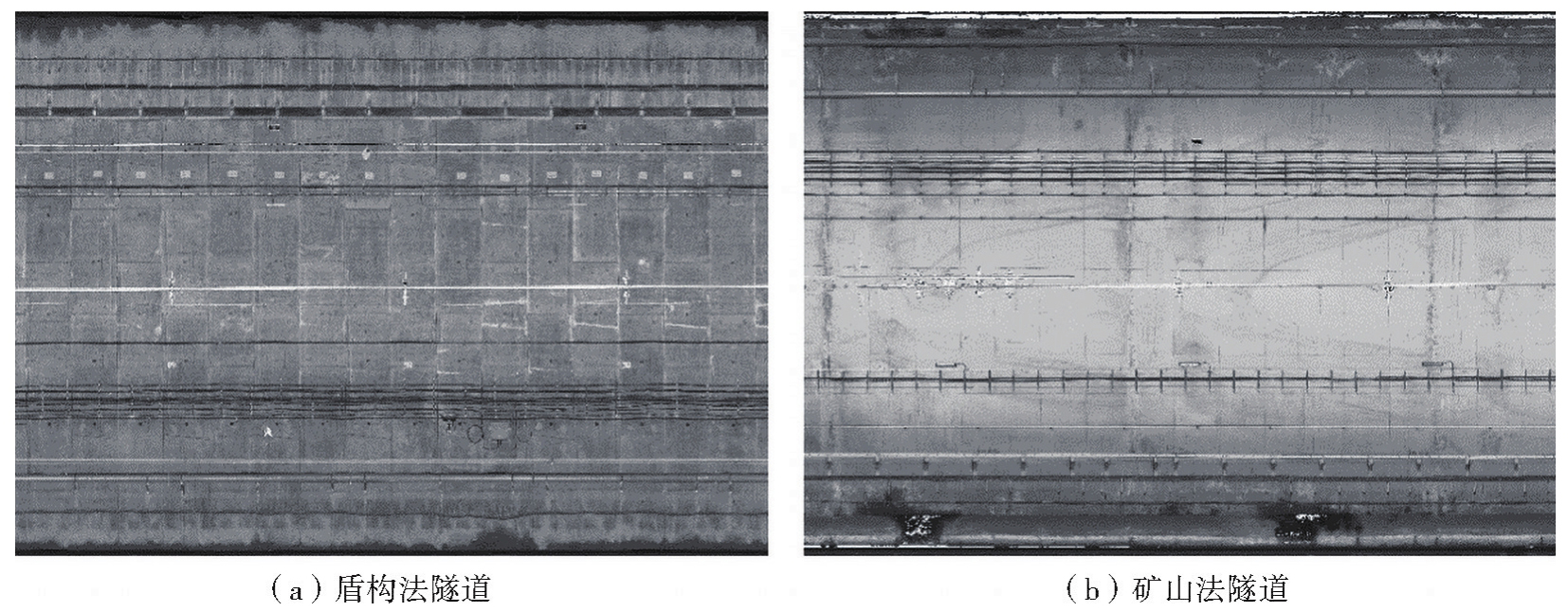
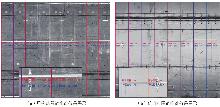
Fig. 7
Registration effect display diagram"

| [1] | 韩宝明, 余怡然, 习喆, 等. 城市轨道交通2023年度统计和分析报告[R]. 北京: 中国城市轨道交通协会, 2024. |
| Han Baoming, Yu Yiran, Xi Zhe, et al. Urban rail transit 2023 annual statistics and analysis report[R]. Beijing: China Association of Metros, 2024. | |
| [2] |
陈军, 刘万增, 武昊, 等. 智能化测绘的基本问题与发展方向[J]. 测绘学报, 2021, 50(8): 995-1005. DOI: .
doi: 10.11947/j.AGCS.2021.20210235 |
|
Chen Jun, Liu Wanzeng, Wu Hao, et al. Smart surveying and mapping: fundamental issues and research agenda[J]. Acta Geodaetica et Cartographica Sinica, 2021, 50(8): 995-1005. DOI: .
doi: 10.11947/j.AGCS.2021.20210235 |
|
| [3] |
纪长琦, 郭肇捷, 孙海丽, 等. 基于移动激光扫描的地铁隧道渗漏水定位及快速检测方法[J]. 测绘学报, 2024, 53(6): 1236-1250. DOI: .
doi: 10.11947/j.AGCS.2024.20230438 |
|
Ji Changqi, Guo Zhaojie, Sun Haili, et al. Location and rapid detection method of water leakage in subway tunnels based on mobile laser scanning[J]. Acta Geodaetica et Cartographica Sinica, 2024, 53(6): 1236-1250. DOI: .
doi: 10.11947/j.AGCS.2024.20230438 |
|
| [4] | 林康, 石波, 杨密, 等. 基于激光点云环缝环号识别的盾构隧道病害定位方法[J]. 铁道科学与工程学报, 2023, 20(12): 4835-4847. |
| Lin Kang, Shi Bo, Yang Mi, et al. Disease location method of shield tunnel based on laser point cloud ring seam ring number identification[J]. Journal of Railway Science and Engineering, 2023, 20(12): 4835-4847. | |
| [5] | Lowe D G. Distinctive image features from scale-invariant keypoints[J]. International Journal of Computer Vision, 2004, 60(2): 91-110. |
| [6] | Bay H, Tuytelaars T, Van Gool L. SURF: speeded up robust features[C]//Proceedings of European Conference on Computer Vision. Berlin: Springer, 2006: 404-417. |
| [7] | He Kaiming, Zhang Xiangyu, Ren Shaoqing, et al. Deep residual learning for image recognition[C]//Proceedings of 2016 IEEE Conference on Computer Vision and Pattern Recognition. Las Vegas: IEEE, 2016: 770-778. |
| [8] | Touvron H, Cord M, Sablayrolles A, et al. Going deeper with image transformers[C]//Proceedings of the IEEE/CVF International Conference on Computer Vision. MontrealL: IEEE, 2021: 32-42. |
| [9] | Chen Hanting, Wang Yunhe, Guo Tianyu, et al. Pre-trained image processing transformer[C]//Proceedings of the IEEE/CVF Conference on Computer Vision and Pattern Recognition. Nashville: IEEE, 2021: 12299-12310. |
| [10] | De Tone D, Malisiewicz T, Rabinovich A. SuperPoint: self-supervised interest point detection and description[PP/OL].[2025-10-30]. https://doi.org/10.48550/arXiv.1712.07629. |
| [11] | Lindenberger P, Sarlin P E, Pollefeys M. LightGlue: local feature matching at light speed[C]//Proceedings of the 2023 IEEE/CVF International Conference on Computer Vision. Paris: IEEE, 2023. |
| [12] | Besl P J, McKay N D. A method for registration of 3D shapes[J]. IEEE Transactions on Pattern Analysis and Machine Intelligence, 1992, 14(2): 239-256. |
| [13] | Qin Zheng, Yu Hao, Wang Changjian, et al. GeoTransformer: fast and robust point cloud registration with geometric transformer[J]. IEEE Transactions on Pattern Analysis and Machine Intelligence, 2023, 45(8): 9806-9821. |
| [14] | Fu Kexue, Luo Jiazheng, Luo Xiaoyuan, et al. Robust point cloud registration framework based on deep graph matching[J]. IEEE Transactions on Pattern Analysis and Machine Intelligence, 2023, 45(5): 6183-6195. |
| [15] | Zai Dawei, Li Jonathan, Guo Yulan, et al. Pairwise registration of TLS point clouds using covariance descriptors and a non-cooperative game[J]. ISPRS Journal of Photogrammetry and Remote Sensing, 2017, 134: 15-29. |
| [16] | 赵文更, 张旭, 邵晴晴. 融合反射强度图像的地铁隧道点云自动配准[J]. 测绘通报, 2020(9): 38-41. |
| Zhao Wengeng, Zhang Xu, Shao Qingqing. Automatic point cloud registration method of subway tunnels based on reflection intensity images[J]. Bulletin of Surveying and Mapping, 2020(9): 38-41. | |
| [17] | Ji Changqi, Sun Haili, Zhong Ruofei, et al. Precise positioning method of moving laser point cloud in shield tunnel based on bolt hole extraction[J]. Remote Sensing, 2022, 14(19): 4791. |
| [18] |
张星, 黄展鹏, 李清泉, 等. 结合配准补偿和空间约束的隧道三维建图方法[J]. 测绘学报, 2025, 54(2): 297-307. DOI: .
doi: 10.11947/j.AGCS.2025.20240018 |
|
Zhang Xing, Huang Zhanpeng, Li Qingquan, et al. 3D tunnel mapping method combining registration compensation and spatial constraint[J]. Acta Geodaetica et Cartographica Sinica, 2025, 54(2): 297-307. DOI: .
doi: 10.11947/j.AGCS.2025.20240018 |
|
| [19] | Fischler M A, Bolles R C. Random sample consensus: a paradigm for model fitting with applications to image analysis and automated cartography[J]. Communications of the ACM, 1981, 24(6): 381-395. |
| [20] | Rakthanmanon T, Campana B, Mueen A, et al. Searching and mining trillions of time series subsequences under dynamic time warping[C]//Proceedings of the 18th ACM SIGKDD International Conference on Knowledge Discovery and Data Mining. Beijing: ACM Press, 2012: 262-270. |
| [21] | Zhong Yu. Intrinsic shape signatures: a shape descriptor for 3D object recognition[C]//Proceedings of 12th IEEE International Conference on Computer Vision Workshops. Kyoto: IEEE, 2009: 689-696. |
| [22] | Fan H Q, Su H, Guibas L. A point set generation network for 3D object reconstruction from a single image[C]//Proceedings of 2017 IEEE Conference on Computer Vision and Pattern Recognition. Honolulu: IEEE, 2017. |
| [1] | Ze YOU, Liying WANG, Yiwei YU, Zhiwei QIN, Chunxi XIE, Yimo GENG, Xinao LI. A segment joint multi-measure interaction index for shield tunnel recognition in RMLS point clouds [J]. Acta Geodaetica et Cartographica Sinica, 2026, 55(6): 1101-1115. |
| [2] | Shuo LIU, Haili SUN, Ruofei ZHONG. A tunnel water leakage detection method based on multi-scale edge information fusion [J]. Acta Geodaetica et Cartographica Sinica, 2026, 55(6): 1116-1127. |
| [3] | Shiliang SU, Juan XIANG, Qingyun DU, Lin LI, Qianqian LI, Lingqi WANG, Jiangyue ZHANG, Mengjun KANG, Min WENG. Re-conceptualizing narrative cartography [J]. Acta Geodaetica et Cartographica Sinica, 2025, 54(8): 1371-1388. |
| [4] | Xinchang ZHANG, Ji QI, Chao TAO, Siyang FU, Mingning GUO, Yongjian RUAN. A survey on cloud removal in optical remote sensing images: progress, challenges, and future works [J]. Acta Geodaetica et Cartographica Sinica, 2025, 54(4): 603-620. |
| [5] | Yuansheng HUA, Boyu CHEN, Xinlin LIU, Yun YANG, Song ZHU, Jiasong ZHU, Qingquan LI. Hybrid visual-inertial measurement method of subway tunnel settlement [J]. Acta Geodaetica et Cartographica Sinica, 2025, 54(12): 2182-2193. |
| [6] | Chao WU, Yongxiang LIANG, Han YUE, Yuanzheng CUI, Bo HUANG. Geographically and temporally weighted Poisson regression for count data [J]. Acta Geodaetica et Cartographica Sinica, 2025, 54(11): 2026-2039. |
| [7] | Haoyu WU, Qing ZHU, Yulin DING, Liu BAO, Li LIU. High-precision digital twin modeling of tunnel surrounding rock driven by data model knowledge collaboration [J]. Acta Geodaetica et Cartographica Sinica, 2025, 54(10): 1893-1906. |
| [8] | Lin TIAN, Qingquan LI, Huachuan MA, Biao XUE, Minglei GUAN, Dejin ZHANG. Underwater photogrammetry positioning of immersed tunnel element interfacing [J]. Acta Geodaetica et Cartographica Sinica, 2024, 53(9): 1671-1678. |
| [9] | Yinzhi ZHAO, Jingui ZOU, Xiaoxi ZHANG, Ze WANG, Xinzhe WANG. An innovative millimeter-level positioning method for multiple millimeter wave radar network in tunnel environment [J]. Acta Geodaetica et Cartographica Sinica, 2024, 53(9): 1679-1693. |
| [10] | Changqi JI, Zhaojie GUO, Haili SUN, Ruofei ZHONG. Location and rapid detection method of water leakage in subway tunnels based on mobile laser scanning [J]. Acta Geodaetica et Cartographica Sinica, 2024, 53(6): 1236-1250. |
| [11] | Mi WANG, Beibei GUO, Yingdong PI, Zhiqi ZHANG, Jing XIAO, Rongfan DAI, Shao XIANG. On-orbit processing technology and verification of Luojia-3 01 satellite [J]. Acta Geodaetica et Cartographica Sinica, 2024, 53(4): 599-609. |
| [12] | WANG Peixiao, ZHANG Tong, NIE Shichao, YANG Jinxuan, WANG Tianjiao. A causal graph convolutional network considering missing values for spatio-temporal prediction [J]. Acta Geodaetica et Cartographica Sinica, 2023, 52(5): 818-830. |
| [13] | LI Haoran, MEI Tiancan, GAO Zhi. 3D face reconstruction based on global ICP and improved Poisson [J]. Acta Geodaetica et Cartographica Sinica, 2023, 52(3): 454-463. |
| [14] | WANG Mi, WU Qianyu. Key problems of remote sensing images intelligent service for constellation [J]. Acta Geodaetica et Cartographica Sinica, 2022, 51(6): 1008-1016. |
| [15] | FANG Lina, SHEN Guixi, YOU Zhilong, GUO Yingya, FU Huasheng, ZHAO Zhiyuan, CHEN Chongcheng. A joint network of point cloud and multiple views for roadside objects recognition from mobile laser point clouds [J]. Acta Geodaetica et Cartographica Sinica, 2021, 50(11): 1558-1573. |
| Viewed | ||||||
|
Full text |
|
|||||
|
Abstract |
|
|||||
