

Acta Geodaetica et Cartographica Sinica ›› 2024, Vol. 53 ›› Issue (6): 1140-1153.doi: 10.11947/j.AGCS.2024.20230358
• Smart Surveying and Mapping • Previous Articles Next Articles
Hao XU1,2,3( ), Qin ZHANG1,2,3(), Li WANG1,2,3, Bao SHU1,2,3, Yuan DU1,2,3, Guanwen HUANG1,2,3
Received:2023-08-25
Published:2024-07-22
Contact:
Qin ZHANG
E-mail:xuhao@chd.edu.cn;dczhangq@chd.edu.cn
About author:XU Hao (1996—), male, PhD candidate, majors in landslide multi-source monitoring data fusion algorithm. E-mail: xuhao@chd.edu.cn
Supported by:CLC Number:
Hao XU, Qin ZHANG, Li WANG, Bao SHU, Yuan DU, Guanwen HUANG. Intelligent site selection method for UAV-dropped GNSS landslide monitoring equipment[J]. Acta Geodaetica et Cartographica Sinica, 2024, 53(6): 1140-1153.
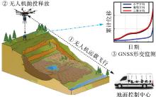
Fig.1
The UAV-dropped GNSS landslide monitoring technology"


Fig.2
Flowchart of intelligent site selection method for UAV-dropped GNSS landslide monitoring equipment"
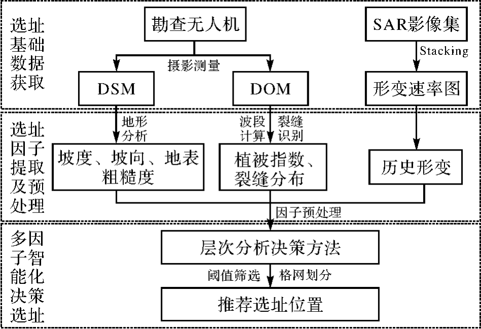
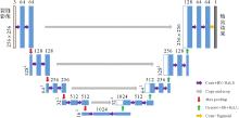
Fig.3
U-Net network model structure"


Fig.4
The crack skeleton and its buffer zone"

Tab.1
Interpretation of the elements in the pairwise comparison matrix"
| Pij | 含义 |
|---|---|
| 1 | 选址因子i和选址因子j同样重要 |
| 3 | 选址因子i比选址因子j稍微重要 |
| 5 | 选址因子i比选址因子j明显重要 |
| 7 | 选址因子i比选址因子j强烈重要 |
| 9 | 选址因子i比选址因子j极端重要 |
| 2、4、6、8 | 上述重要性的中间值 |
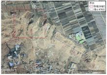
Fig.5
Google image of the site selection trial area"
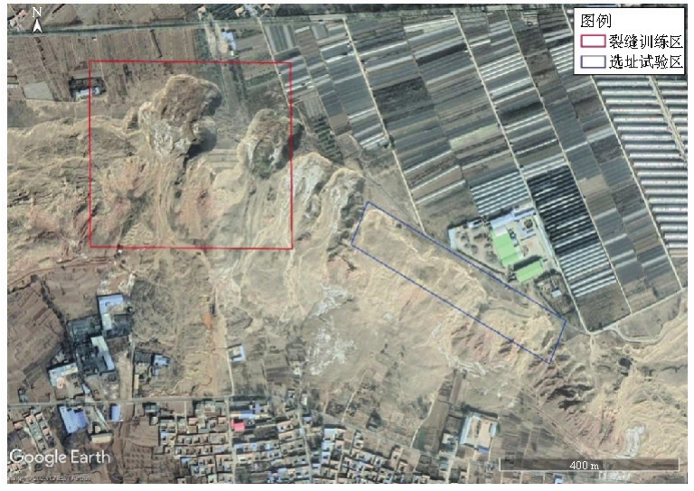

Fig.6
UAV high resolution DOM and DSM"
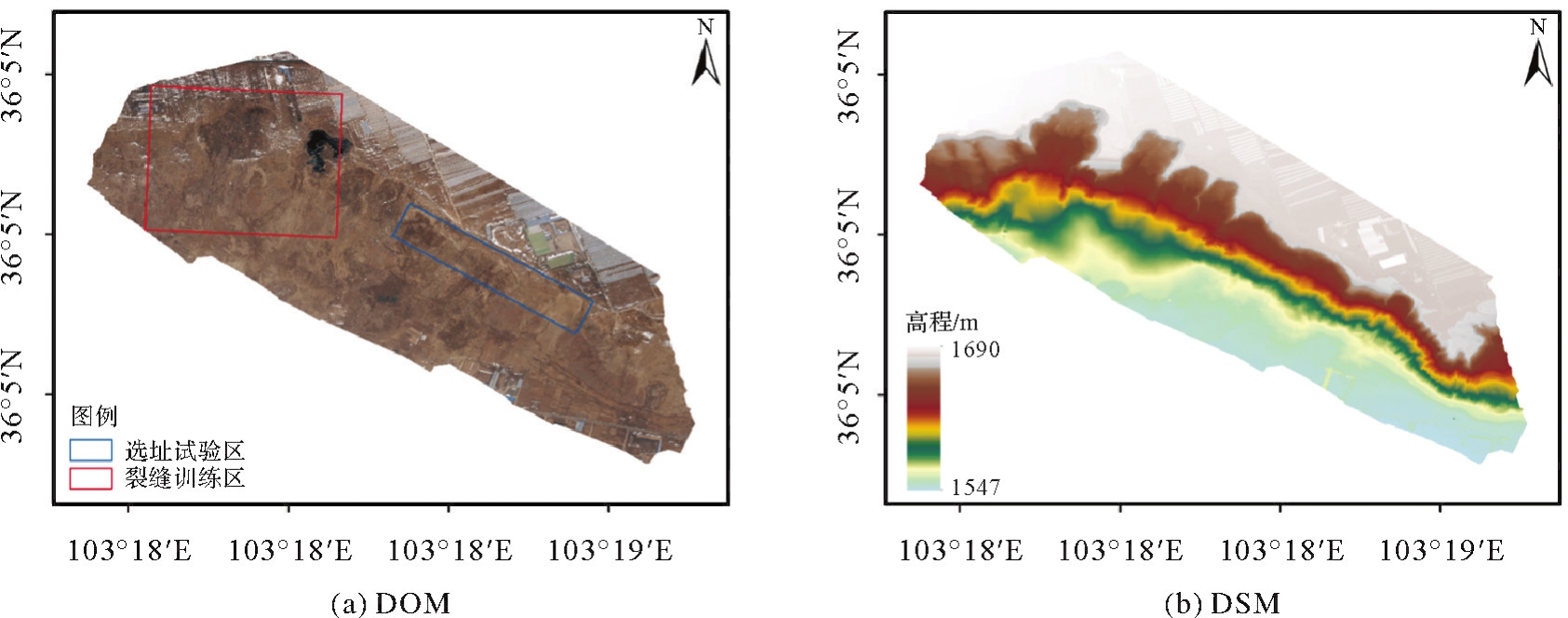
Fig.7
The annual average LOS deformation rate in the Heifangtai region"
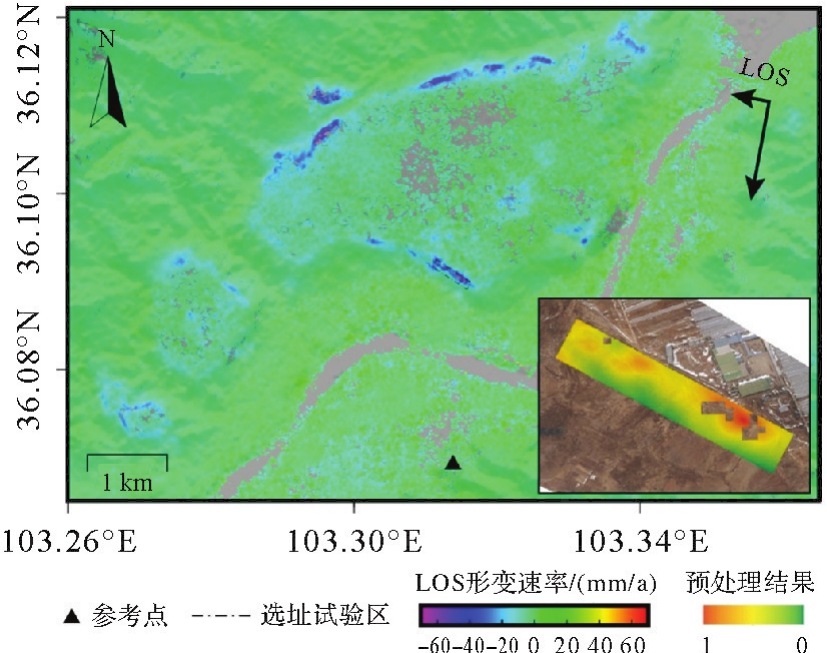
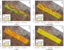
Fig.8
Pre-processing results of site selection factors for slope, aspect, terrain ruggedness and vegetation index"


Fig.9
The example of crack image, label file and U-Net prediction map"
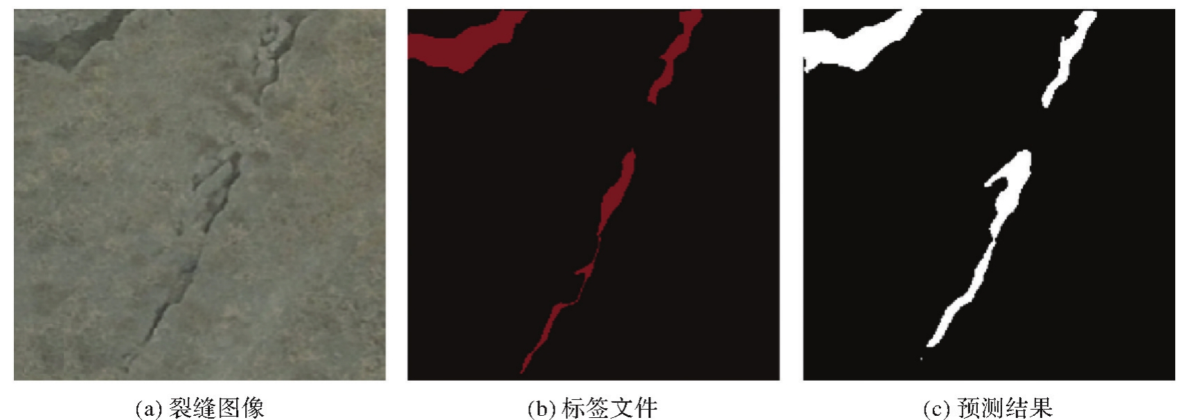
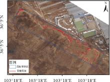
Fig.10
Skeleton distribution of cracks"

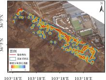
Fig.11
Pre-processing results of crack distribution site selection factor"
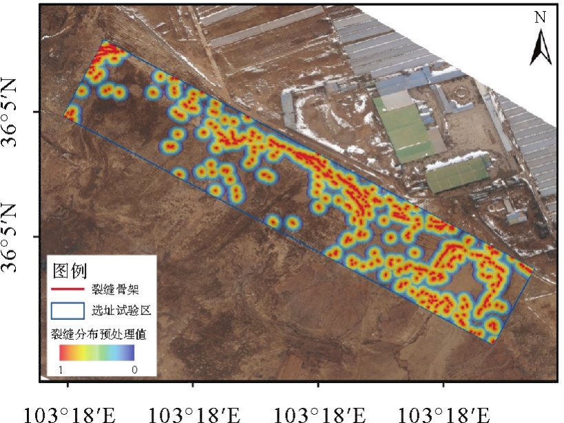

Fig.12
Site suitability and recommended locations within the site selection trial area"

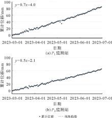
Fig.13
GNSS monitoring station deformation time series"
Tab.2
Factors pre-processed values and suitability values for each site of the monitoring site"
| 站点名 | 历史形变 | 裂缝分布 | 坡度 | 地表粗糙度 | 植被指数 | 坡向 | 适宜性值 |
|---|---|---|---|---|---|---|---|
| P1 | 0.47 | 0.97 | 0.57 | 0.66 | 0.71 | 0.8 | 0.69 |
| P2 | 0.39 | 0.82 | 0.24 | 0.70 | 0.64 | 0.8 | 0.56 |

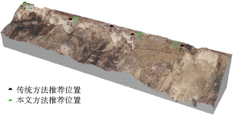
Fig.14
Expert site selection recommended location distribution"
| [1] | 邓李政, 袁宏永, 张鸣之, 等. 滑坡变形监测预警技术研究进展[J]. 清华大学学报(自然科学版), 2023, 63(6):849-864. |
| DENG Lizheng, YUAN Hongyong, ZHANG Mingzhi, et al. Research progress on landslide deformation monitoring and early warning technology[J]. Journal of Tsinghua University (Science and Technology), 2023, 63(6):849-864. | |
| [2] | INTRIERI E, CARLÀ T, GIGLI G. Forecasting the time of failure of landslides at slope-scale: a literature review[J]. Earth Science Reviews, 2019, 193:333-349. |
| [3] | QIU Dongwei, WANG Laiyang, LUO Dean, et al. Landslide monitoring analysis of single-frequency BDS/GPS combined positioning with constraints on deformation characteristics[J]. Survey Review, 2019, 51(367):364-372. |
| [4] | WANG Pengxu, LIU Hui, NIE Guigen, et al. Performance evaluation of a real-time high-precision landslide displacement detection algorithm based on GNSS virtual reference station technology[J]. Measurement, 2022, 199:111457. |
| [5] | 陈孜, 黄观文, 白正伟, 等. 基于低成本毫米级GNSS技术的膨胀土边坡现场监测[J]. 中南大学学报(自然科学版), 2022, 53(1):214-224. |
| CHEN Zi, HUANG Guanwen, BAI Zhengwei, et al. Field monitoring of expansive soil slope based on low-cost millimeter-sized GNSS technology[J]. Journal of Central South University (Science and Technology), 2022, 53(1):214-224. | |
| [6] | BAI Dongxin, TANG Jingtian, LU Guangyin, et al. The design and application of landslide monitoring and early warning system based on microservice architecture[J]. Geomatics, Natural Hazards and Risk, 2020, 11(1):928-948. |
| [7] | 张勤, 白正伟, 黄观文, 等. GNSS滑坡监测预警技术进展[J]. 测绘学报, 2022, 51(10):1985-2000.DOI:10.11947/j.AGCS.2022.20220299. |
| ZHANG Qin, BAI Zhengwei, HUANG Guanwen, et al. Review of GNSS landslide monitoring and early warning[J]. Acta Geodaetica et Cartographica Sinica, 2022, 51(10):1985-2000.DOI:10.11947/j.AGCS.2022.20220299. | |
| [8] | 王利, 许豪, 舒宝, 等. 滑坡灾害GNSS监测技术研究进展与展望[J]. 导航定位与授时, 2023, 10(1):12-26. |
| WANG Li, XU Hao, SHU Bao, et al. Research progress and prospects of GNSS deformation monitoring technology for landslide hazards[J]. Navigation Positioning and Timing, 2023, 10(1):12-26. | |
| [9] | BRACH M, ZASADA M. The effect of mounting height on GNSS receiver positioning accuracy in forest conditions[J]. Journal for Theory and Application of Forestry Engineering, 2014, 35(2):245-253. |
| [10] | 戴可人, 沈月, 吴明堂, 等. 联合InSAR与无人机航测的白鹤滩库区蓄水前地灾隐患广域识别[J]. 测绘学报, 2022, 51(10):2069-2082.DOI:10.11947/j.AGCS.2022.20220305. |
| DAI Keren, SHEN Yue, WU Mingtang, et al. Identification of potential landslides in Baihetan dam area before the impoundment by combining InSAR and UAV survey[J]. Acta Geodaetica et Cartographica Sinica, 2022, 51(10):2069-2082.DOI:10.11947/j.AGCS.2022.20220305. | |
| [11] | 许强, 郭晨, 董秀军. 地质灾害航空遥感技术应用现状及展望[J]. 测绘学报, 2022, 51(10):2020-2033.DOI:10.11947/j.AGCS.2022.20220302. |
| XU Qiang, GUO Chen, DONG Xiujun. Application status and prospect of aerial remote sensing technology for geohazards[J]. Acta Geodaetica et Cartographica Sinica, 2022, 51(10):2020-2033.DOI:10.11947/j.AGCS.2022.20220302. | |
| [12] | 陈巧, 袁飞云, 付霞, 等. 无人机摄影测量技术在阿娘寨滑坡应急调查中的应用[J]. 测绘通报, 2023 (1):77-83. |
| CHEN Qiao, YUAN Feiyun, FU Xia, et al. Application of UAV photogrammetry technology in emergency investigation of Aniangzhai landslide[J]. Bulletin of Surveying and Mapping, 2023 (1):77-83. | |
| [13] | 王川, 涂宽, 谌华, 等. Stacking InSAR和IPTA技术应用于探测宁夏隆德县滑坡隐患[J]. 自然灾害学报, 2022, 31(5):222-234. |
| WANG Chuan, TU Kuan, CHEN Hua, et al. Application of stacking InSAR and IPTA techniques for potential lanslide detection in Longde County, Ningxia[J]. Journal of Natural Disasters, 2022, 31(5):222-234. | |
| [14] | MEYER G E, NETO J C. Verification of color vegetation indices for automated crop imaging applications[J]. Computers and Electronics in Agriculture, 2008, 63(2):282-293. |
| [15] | 许强, 汤明高, 徐开祥, 等. 滑坡时空演化规律及预警预报研究[J]. 岩石力学与工程学报, 2008, 27(6):1104-1112. |
| XU Qiang, TANG Minggao, XU Kaixiang, et al. Research on space-time evolution laws and early warning-prediction of landslides[J]. Chinese Journal of Rock Mechanics and Engineering, 2008, 27(6):1104-1112. | |
| [16] | RONNEBERGER O, FISCHER P, BROX T. U-Net: convolutional networks for biomedical image segmentation[C]//Proceedings of 2015 Medical Image Computing and Computer-Assisted Intervention. Cham: Springer, 2015: 234-241. |
| [17] | YAN Qiuyu, ZHAO Wufan, HUANG Xiao, et al. Automated delineation of smallholder farm fields using fully convolutional networks and generative adversarial networks[J]. Journal of Geodesy and Geoinformation Science, 2022, 5(4):10-22. |
| [18] | ZHANG T Y, SUEN C Y. A fast parallel algorithm for thinning digital patterns[J]. Communications of the ACM, 1984, 27(3):236-239. |
| [19] | SAATY T L. The analytic hierarchy process: planning, priority setting, resources allocation[M]. New York: McGraw-Hill, 1980. |
| [20] | HAN Junqiang, HUANG Guanwen, ZHANG Qin, et al. A new azimuth-dependent elevation weight (ADEW) model for real-time deformation monitoring in complex environment by multi-GNSS[J]. Sensors, 2018, 18(8):2473. |
| [21] | 刘健, 黄观文, 杜源, 等. 基于基准站信噪比先验信息的GNSS观测数据多路径误差识别方法及应用[J]. 地球科学与环境学报, 2022, 44(2):352-362. |
| LIU Jian, HUANG Guanwen, DU Yuan, et al. Method and application of identifying multipath errors in GNSS observation data based on prior information of base station's signal-to-noise ratio[J]. Journal of Earth Sciences and Environment, 2022, 44(2):352-362. | |
| [22] | POHEKAR S D, RAMACHANDRAN M. Application of multi-criteria decision making to sustainable energy planning: a review[J]. Renewable and Sustainable Energy Reviews, 2004, 8(4):365-381. |
| [23] | XU Qiang, LI Weile, JU Yuanzhen, et al. Multitemporal UAV-based photogrammetry for landslide detection and monitoring in a large area: a case study in the Heifangtai terrace in the Loess Plateau of China[J]. Journal of Mountain Science, 2020, 17(8):1826-1839. |
| [24] | XU Qiang, PENG Dalei, ZHANG Shuai, et al. Successful implementations of a real-time and intelligent early warning system for loess landslides on the Heifangtai terrace, China[J]. Engineering Geology, 2020, 278:105817. |
| [25] | KONG Jiaxu, ZHUANG Jianqi, ZHAN Jiewei, et al. A landslide in Heifangtai, northwest of the Chinese Loess Plateau: triggered factors, movement characteristics, and failure mechanism[J]. Landslides, 2021, 18(10):3407-3419. |
| [26] | HUANG Guanwen, WANG Duo, DU Yuan, et al. Deformation feature extraction for GNSS landslide monitoring series based on robust adaptive sliding-window algorithm[J]. Frontiers in Earth Science, 2022, 10:1-11. |
| [27] | YU Chen, LI Zhenhong, PENNA N T. Interferometric synthetic aperture radar atmospheric correction using a GPS-based iterative tropospheric decomposition model[J]. Remote Sensing of Environment, 2018, 204:109-121. |
| [28] | YU Chen, LI Zhenhong, PENNA N T, et al. Generic atmospheric correction model for interferometric synthetic aperture radar observations[J]. Journal of Geophysical Research (Solid Earth), 2018, 123(10):9202-9222. |
| [29] | YU Chen, PENNA N T, LI Zhenhong. Generation of real-time mode high-resolution water vapor fields from GPS observations[J]. Journal of Geophysical Research: Atmospheres, 2017, 122(3):2008-2025. |
| [30] | YU Chen, LI Zhenhong, BAI Lin, et al. Successful applications of generic atmospheric correction online service for InSAR (GACOS) to the reduction of atmospheric effects on InSAR observations[J]. Journal of Geodesy and Geoinformation Science, 2021 (1):109-115. |
| [31] | KINGMA D P, BA J. Adam: a method for stochastic optimization[EB/OL]. [2023-08-08]. https://arxiv.org/pdf/1412.6980.pdf. |
| [1] | Jinwei BU, Shuhui LIU, Shunshuang XU, Tongsu XIANG, Qiulan WANG, Chaoying JI, Xiaoqing ZUO. Construction of an empirical model for estimating the global wave period of spaceborne GNSS-R [J]. Acta Geodaetica et Cartographica Sinica, 2026, 55(4): 684-697. |
| [2] | Tangting WU, Xinyu LUO, Liguo LU, Zhanke LIU, Nengfang CHAO. Assessment of water resource changes and drought characteristics in the Shaanxi, Gansu and Ningxia region based on GNSS and GRACE/GRACE-FO [J]. Acta Geodaetica et Cartographica Sinica, 2026, 55(3): 439-450. |
| [3] | Zhongmin MA, Shuangcheng ZHANG, Xin ZHOU, Qi LIU, Ning LIU, Hengli WANG. A flood monitoring method using FY-3 GNSS-R accounting for surface reflectivity uncertainty: a case study of the August 2 Guangdong rainstorm disaster [J]. Acta Geodaetica et Cartographica Sinica, 2026, 55(3): 451-464. |
| [4] | Qingyun YAN, Zixuan GUO, Yuanjin PAN, Yan JIA, Shuanggen JIN. Quantitative driving factors and zoning patterns of GNSS-R land surface reflectivity spatial heterogeneity [J]. Acta Geodaetica et Cartographica Sinica, 2026, 55(2): 315-327. |
| [5] | Qingzhi ZHAO, Duoduo JIANG, Yibin YAO, Zhi MA, Yongjie MA, Haojie LI, Ruirui XUE. An adaptive method for selecting the optimal GNSS satellite signal for water vapor tomography [J]. Acta Geodaetica et Cartographica Sinica, 2026, 55(1): 25-35. |
| [6] | Deying YU, Houpu LI, Yi LIU, Shuguang WU, Deyan LI, Mingchao LI, Wenkui LI, Shaofeng BIAN. A DBSCAN-based RAIM algorithm for multiple gross error identification [J]. Acta Geodaetica et Cartographica Sinica, 2026, 55(1): 59-72. |
| [7] | Dongliang CHENG, Lingqiu CHEN, Zhiyong HUANG, Shubo QIAO, Dandan WANG, Yaming YAN. Performance evaluation of COATS-based multi-mode and multi-frequency iGNSS-R altimetry [J]. Acta Geodaetica et Cartographica Sinica, 2026, 55(1): 73-89. |
| [8] | Yarong LUO, Wentao LU, Chi GUO, Jingnan LIU. Left-handed symmetry equivariant filtering model and algorithm for GNSS/INS integrated navigation [J]. Acta Geodaetica et Cartographica Sinica, 2025, 54(8): 1389-1403. |
| [9] | Yangyi CHEN, Kai ZHENG, Xiaohong ZHANG, Mingkui WU, Pengxu WANG, Wenju FU, Kezhong LIU. GPS/Galileo/BDS overlapping frequencies multipath error analysis and modeling [J]. Acta Geodaetica et Cartographica Sinica, 2025, 54(8): 1427-1438. |
| [10] | Jianzhang LI, Haowen YAN, Weifang YANG, Xiaoning SU. GNSS pseudo trigonometric leveling method [J]. Acta Geodaetica et Cartographica Sinica, 2025, 54(7): 1170-1177. |
| [11] | Qingzhi ZHAO, Lulu CHANG, Yibin YAO, Haojie LI. A method for constructing a hydrological drought index integrated with GNSS and meteorological data [J]. Acta Geodaetica et Cartographica Sinica, 2025, 54(7): 1192-1205. |
| [12] | Qianxin WANG, Chao HU, Tong CHENG. A method for satellite ultra-rapid orbit and clock offset estimation based on the prior information of the GNSS clock parameters [J]. Acta Geodaetica et Cartographica Sinica, 2025, 54(6): 982-994. |
| [13] | Yang SHEN, Guangyun LI, Mingjian CHEN, Linyang LI, Xingyu SHI, Wei CAI, Weifeng HAO. Assessment of GNSS ionosphere models based on FY-3 TEC in polar regions [J]. Acta Geodaetica et Cartographica Sinica, 2025, 54(6): 995-1008. |
| [14] | Shunqiang HU, Kejie CHEN, Xiaoxing HE, Hai ZHU, Tan WANG. The impact of environmental loading on nonlinear variations of 3D coordinate time series of GNSS stations in Sichuan and Yunnan region [J]. Acta Geodaetica et Cartographica Sinica, 2025, 54(5): 805-818. |
| [15] | Wentao YANG, Fei GUO, Xiaohong ZHANG, Zhiyu ZHANG, Yifan ZHU, Zheng LI, Ziheng WU. Soil moisture and freeze-thaw map using GNSS reflectometer and SMAP radiometer for Qinghai-Xizang Plateau [J]. Acta Geodaetica et Cartographica Sinica, 2025, 54(4): 725-735. |
| Viewed | ||||||
|
Full text |
|
|||||
|
Abstract |
|
|||||