

Acta Geodaetica et Cartographica Sinica ›› 2025, Vol. 54 ›› Issue (2): 272-285.doi: 10.11947/j.AGCS.2025.20240103
• Marine Survey • Previous Articles Next Articles
Hongkai SHI1( ), Xiufeng HE1(), Yihao WU1, Xiangtian ZHENG2, Minfeng SONG1
Received:2024-03-15
Online:2025-03-11
Published:2025-03-11
Contact:
Xiufeng HE
E-mail:shk@hhu.edu.cn;xfhe@hhu.edu.cn
About author:SHI Hongkai (1993—), male, PhD, majors in satellite altimetry and ocean dynamic modeling. E-mail: shk@hhu.edu.cn
Supported by:CLC Number:
Hongkai SHI, Xiufeng HE, Yihao WU, Xiangtian ZHENG, Minfeng SONG. Waveform contamination identification and accurate sea surface height extraction algorithm for high-frequency fully-focused SAR in severely interfered coastal regions[J]. Acta Geodaetica et Cartographica Sinica, 2025, 54(2): 272-285.
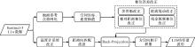
Fig. 1
Flowchart of FFSAR L1a signal processing"
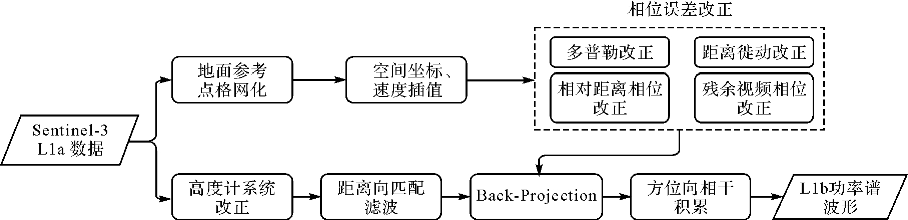

Fig. 2
SSH extraction algorithm based on contamination rejection and range compensation"
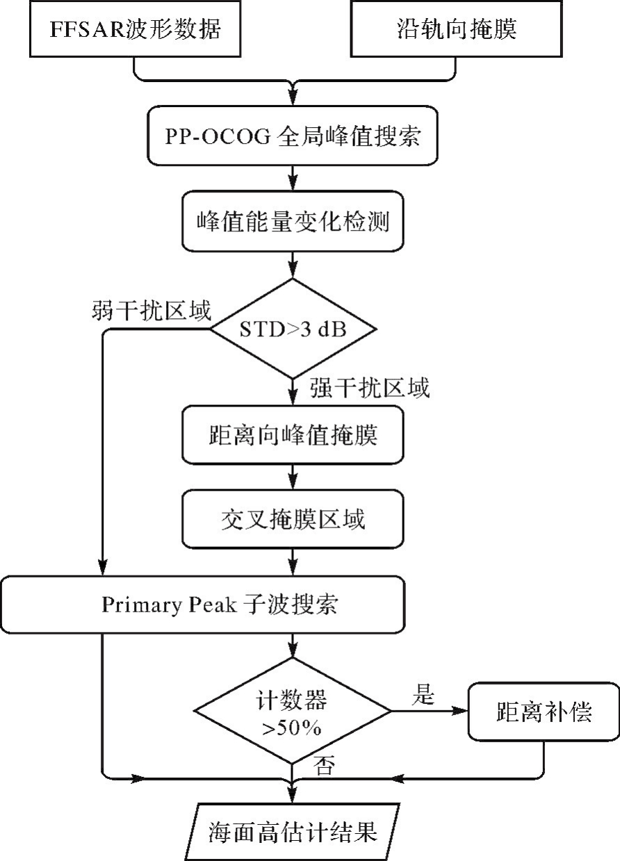
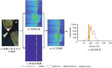
Fig. 3
Radargram and its peak search results"

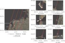
Fig. 4
Research area and the distribution of the Sentinel-3A tracks"

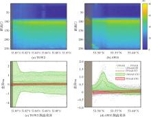
Fig. 5
Radargram of the FFSAR from less contaminated area and its distribution of SSH"

Tab. 1
The STD of differences between FFSAR and tide gauge data under different sampling rates in low interference sea areas"
| 采样率/Hz | TGW2/m | AWG/m |
|---|---|---|
| 20 | 0.136 | 0.115 |
| 80 | 0.141 | 0.117 |
| 200 | 0.139 | 0.118 |
| 600 | 0.160 | 0.145 |
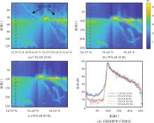
Fig. 6
Power spectrum of Sentinel-3A (TGWD Feb. 2017) using UFSAR and FFSAR"

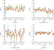
Fig. 7
Validation results from different research area at different sampling rates"

Tab. 2
Statistics of the difference between FFSAR and tide gauge under contaminated area"
| 采样率/Hz | TGWD/m | EEMSHAEN/m | DENHELDER/m | IJMON/m |
|---|---|---|---|---|
| 20 | 0.36 | 0.31 | 0.68 | 0.17 |
| 80 | 0.35 | 0.27 | 0.56 | 0.18 |
| 200 | 0.22 | 0.22 | 0.48 | 0.14 |
| 600 | 0.27 | 0.26 | 0.51 | 0.15 |
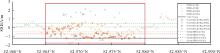
Fig. 8
FFSAR range compensation results at TGWD station (Sep. 2017) under different sampling rates"

Tab. 3
Statistics of the difference between FFSAR results and tide gauge at TGWD"
| 测高结果/Hz | Max/m | Min/m | Mean/m | SD/m |
|---|---|---|---|---|
| 20 | 0.74 | -0.82 | 0.05 | 0.36 |
| 80 | 0.85 | -0.70 | 0.10 | 0.35 |
| 200 | 0.43 | -0.36 | 0.04 | 0.22 |
| 600 | 0.51 | -0.41 | 0.05 | 0.27 |
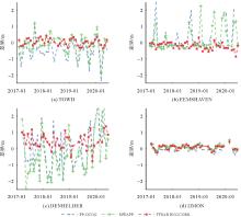
Fig. 9
Validation results from different research area at 200 Hz sampling rate"

Tab. 4
STD of the difference between different altimetry results and tide gauge"
| 测高结果 | TGWD | EEMSHAVEN | DENHELDER | IJMON |
|---|---|---|---|---|
| 200 Hz PP-OCOG | 0.57 | 0.76 | 1.33 | 0.20 |
| 200 Hz MWaPP | 0.56 | 0.73 | 1.28 | 0.13 |
| 200 Hz FFSAR_RNG | 0.22 | 0.22 | 0.48 | 0.14 |
| [1] | 许厚泽, 王海瑛, 陆洋, 等. 利用卫星测高数据推求中国近海及邻域大地水准面起伏和重力异常研究[J]. 地球物理学报, 1999(4): 465-471. |
| XU Houze, WANG Haiying, LU Yang, et al. Geoid undulations and gravity anomalies from T/P and ERS-1 altimeter data in the China sea and vicinity[J]. Chinese Journal of Geophysics (in Chinese), 1999, 42(4): 465-471. | |
| [2] | 李建成, 金涛勇. 卫星测高技术及应用若干进展[J]. 测绘地理信息, 2013, 38(4): 1-8. |
| LI Jiancheng, JIN Taoyong. On the main progress of satellite altimetry and its applications[J]. Journal of Geomatics, 2013, 38(4): 1-8. | |
| [3] | SHI Hongkai, HE Xiufeng, WU Yihao, et al. Spectrally consistent mean dynamic topography by combining mean sea surface and global geopotential model through a least squares-based approach[J]. Frontiers in Earth Science, 2022, 10: 795935. |
| [4] | VIGNUDELLI S, AKHIR M F, ZAINOL Z, et al. Coastal altimetry[M]. San Diego: Elsevier, 2023: 1-19. |
| [5] | WU Yihao, ABULAITIJIANG A, FEATHERSTONE W E, et al. Coastal gravity field refinement by combining airborne and ground-based data[J]. Journal of Geodesy, 2019, 93(12): 2569-2584. |
| [6] | VIGNUDELLI S, BIROL F, BENVENISTE J, et al. Satellite altimetry measurements of sea level in the coastal zone[J]. Surveys in Geophysics, 2019, 40(6): 1319-1349. |
| [7] | IDRIS N H, VIGNUDELLI S, DENG Xiaoli. Assessment of retracked sea levels from Sentinel-3A synthetic aperture radar (SAR) mode altimetry over the marginal seas at Southeast Asia[J]. International Journal of Remote Sensing, 2021, 42(4): 1535-1555. |
| [8] | DENG X, FEATHERSTONE W E. A coastal retracking system for satellite radar altimeter waveforms: application to ERS-2 around Australia[J]. Journal of Geophysical Research: Oceans, 2006, 111(C6): 2005JC003039. |
| [9] | RANEY R K. The delay/Doppler radar altimeter[J]. IEEE Transactions on Geoscience and Remote Sensing, 36(5): 1578-1588. |
| [10] | LABROUE S, BOY F, PICOT N, et al. First quality assessment of the Cryosat-2 altimetric system over ocean[J]. Advances in Space Research, 2012, 50(8): 1030-1045. |
| [11] | JIANG Liguang, NIELSEN K, DINARDO S, et al. Evaluation of Sentinel-3 SRAL SAR altimetry over Chinese rivers[J]. Remote Sensing of Environment, 2020, 237: 111546. |
| [12] | PENG Fukai, DENG Xiaoli. Validation of Sentinel-3A SAR mode sea level anomalies around the Australian coastal region[J]. Remote Sensing of Environment, 2020, 237: 111548. |
| [13] | DINARDO S, MARALDI C, CADIER E, et al. Sentinel-6 MF Poseidon-4 radar altimeter: main scientific results from S6PP LRM and UF-SAR chains in the first year of the mission[J]. Advances in Space Research, 2024, 73(1): 337-375. |
| [14] | BOY F, DESJONQUERES J D, PICOT N, et al. CryoSat-2 SAR-mode over oceans: processing methods, global assessment, and benefits[J]. IEEE Transactions on Geoscience and Remote Sensing, 2017, 55(1): 148-158. |
| [15] | DINARDO S. Techniques and applications for satellite SAR altimetry over water, land and ice[DB/OL]. Darmstadt: Technische Universität. [2024-04-03]. https://tuprints.ulb.tu-darmstadt.de/id/eprint/11343. |
| [16] | KLEINHERENBRINK M, NAEIJE M, SLOBBE C, et al. The performance of CryoSat-2 fully-focussed SAR for inland water-level estimation[J]. Remote Sensing of Environment, 2020, 237: 111589. |
| [17] | EGIDO A, SMITH W H F. Fully focused SAR altimetry: theory and applications[J]. IEEE Transactions on Geoscience and Remote Sensing, 2017, 55(1): 392-406. |
| [18] | HERNÁNDEZ-BURGOS S, GIBERT F, BROQUETAS A, et al. A fully focused SAR Omega-K closed-form algorithm for the Sentinel-6 radar altimeter: methodology and applications[J]. IEEE Transactions on Geoscience and Remote Sensing, 2024, 62: 3367544. |
| [19] | 施宏凯. 融合SAR高度计及多源测高数据的海岸带稳态海面地形重建方法研究[D]. 南京: 河海大学, 2022. |
| SHI Hongkai. Coastal mean dynamic topography modeling method from SAR and multi-source altimetric data[D]. Nanjing: Hohai University, 2022. | |
| [20] | RIEU P, MOREAU T, AMAROUCHE L, et al. From unfocused to fully-focused SAR processing: benefits for different surfaces[C]//Proceedings of 2018 Progress in Radar Altimetry Symposium. Ponta Delgada: [s.n.], 2018: 20. |
| [21] | SCHLEMBACH F, EHLERS F, KLEINHERENBRINK M, et al. Benefits of fully focused SAR altimetry to coastal wave height estimates: a case study in the North Sea[J]. Remote Sensing of Environment, 2023, 289: 113517. |
| [22] | EGIDO A, DINARDO S, RAY C. The case for increasing the posting rate in delay/Doppler altimeters[J]. Advances in Space Research, 2021, 68(2): 930-936. |
| [23] | FENG Hui, EGIDO A, VANDEMARK D, et al. Exploring the potential of Sentinel-3 delay Doppler altimetry for enhanced detection of coastal currents along the Northwest Atlantic shelf[J]. Advances in Space Research, 2023, 71(1): 997-1016. |
| [24] | CHOI J H, JANG J H, ROH J E. Design of an FMCW radar altimeter for wide-range and low measurement error[J]. IEEE Transactions on Instrumentation and Measurement, 2015, 64(12): 3517-3525. |
| [25] | 杨双宝. 基于合成孔径技术的高精度雷达高度计技术研究[D]. 北京: 中国科学院研究生院(空间科学与应用研究中心), 2007. |
| YANG Shuangbao. High-precision radar altimeter technology based on synthetic aperture techniques[D]. Beijing: Chinese Academy of Sciences (The National Space Science Center), 2007. | |
| [26] | KLEINHERENBRINK M, SMITH W H F, NAEIJE M C, et al. The second-order effect of Earth's rotation on Cryosat-2 fully focused SAR processing[J]. Journal of Geodesy, 2020, 94(1): 7-16. |
| [27] | ROUFFI F. Product data format specification - SRAL and MWR Level 1 products[EB/OL]. [2023-11-15]. https://sentinels.copernicus.eu/documents/247904/2753172/Sentinel-3-Product-Data-Format-Specification-Level-1-products.pdf/2b7c773b-44ca-447e-9b86-f7ebd231261c?t=1611592438951. |
| [28] | EHLERS F, SCHLEMBACH F, KLEINHERENBRINK M, et al. Validity assessment of SAMOSA retracking for fully-focused SAR altimeter waveforms[J]. Advances in Space Research, 2023, 71(3): 1377-1396. |
| [29] | BOY F, CRETAUX J F, BOUSSAROQUE M, et al. Improving Sentinel-3 SAR mode processing over lake using numerical simulations[J]. IEEE Transactions on Geoscience and Remote Sensing, 2022, 60: 1-18. |
| [30] | JAIN M, ANDERSEN O B, DALL J, et al. Sea surface height determination in the Arctic using Cryosat-2 SAR data from primary peak empirical retrackers[J]. Advances in Space Research, 2015, 55(1): 40-50. |
| [31] | YUAN Jiajia, GUO Jinyun, ZHU Chengcheng, et al. SDUST2020 MSS: a global 1′×1′ mean sea surface model determined from multi-satellite altimetry data[J]. Earth System Science Data, 2023, 15(1): 155-169. |
| [32] | LARSON K M, RAY R D, WILLIAMS S D P. A 10-year comparison of water levels measured with a geodetic GPS receiver versus a conventional tide gauge[J]. Journal of Atmospheric and Oceanic Technology, 2017, 34(2): 295-307. |
| [33] | HOFSTEDE J L A. Process-response analysis for Hörnum tidal inlet in the German sector of the Wadden sea[J]. Quaternary International, 1999, 60(1): 107-117. |
| [34] | TOMIĆ M, BREILI K, GERLACH C, et al. Validation of retracked Sentinel-3 altimetry observations along the Norwegian coast[J]. Advances in Space Research, 2024, 73(8): 4067-4090. |
| [35] | KE B, ZHANG L, XU J, et al. Determination of the mean dynamic ocean topography model through combining multi-source gravity data and DTU15 MSS around China's coast[J]. Advances in Space Research, 2019, 63(1): 203-212. |
| [36] | SCHLEMBACH F, PASSARO M, DETTMERING D, et al. Interference-sensitive coastal SAR altimetry retracking strategy for measuring significant wave height[J]. Remote Sensing of Environment, 2022, 274: 112968. |
| [1] | Hongmei WANG, Lihua WANG, Benhua TAN, Xiaoyi JIANG, Lili SONG, Weiwei SUN. SAR high-precision inversion of sea surface current over offshore China [J]. Acta Geodaetica et Cartographica Sinica, 2026, 55(4): 588-603. |
| [2] | Yi GAO, Xin LIU, Daocheng YU, Shaoshuai YA, Shaofeng BIAN, Heping SUN, Jinyun GUO. An automated seamount detection method integrating vertical gravity gradient anomaly and seafloor topographic models [J]. Acta Geodaetica et Cartographica Sinica, 2026, 55(4): 647-657. |
| [3] | Siyuan BAI, Hongzhou CHAI, Qing WU, Gen LI, Yuhao YE, Honglei MA. Buoys-aided integrated navigation method for UUV under ice with sea ice drift compensation [J]. Acta Geodaetica et Cartographica Sinica, 2026, 55(4): 698-707. |
| [4] | Jiachao BIAN, Shuqiang XUE, Shuang ZHAO, Jixing ZHU, Jinlai GAO, Baojin LI. Multi-window joint robust estimation for marine acoustic navigation [J]. Acta Geodaetica et Cartographica Sinica, 2026, 55(3): 515-524. |
| [5] | Shuqiang XUE, Jinlai GAO, Shuang ZHAO, Baojin LI, Yunhao FAN, Bingqian LIU. A static acoustic delay compensation positioning model [J]. Acta Geodaetica et Cartographica Sinica, 2026, 55(2): 275-286. |
| [6] | Qiqian SUN, Shuaidong JIA, Zhicheng LIANG, Xianpeng LIU, Haoshi SONG. A method for constructing digital depth model of strait passage considering crowdsourced bathymetric data characteristics [J]. Acta Geodaetica et Cartographica Sinica, 2026, 55(1): 90-100. |
| [7] | Gen LI, Hongzhou CHAI, Kaidi JIN, Zhao ZHAN. Underwater terrain matching method based on robust particle filter [J]. Acta Geodaetica et Cartographica Sinica, 2025, 54(10): 1841-1851. |
| [8] | Shaobo LI. Research on sub-bottom buried target detection and acoustic classification of sediment [J]. Acta Geodaetica et Cartographica Sinica, 2025, 54(10): 1911-1911. |
| [9] | Dongdong PU, Hongzhou CHAI, Yongzhong OUYANG, Chao DONG. Hierarchical encryption matching algorithm for adjacent strip splicing in airborne LiDAR bathymetry [J]. Acta Geodaetica et Cartographica Sinica, 2025, 54(8): 1439-1451. |
| [10] | Yijie ZHAO, Junting WANG, Tianhe XU, Jianxu SHU, Yangfan LIU. Correction method for time-varying sound speed errors in underwater geodetic datum positioning [J]. Acta Geodaetica et Cartographica Sinica, 2025, 54(8): 1452-1463. |
| [11] | Xiaodong CHEN, Meng YANG, Yuan YUAN, Wei FENG, Jinway HWANG, Min ZHONG. Evaluation of the accuracy and spatial resolution of SWOT_02 marine gravity model in China's offshore regions [J]. Acta Geodaetica et Cartographica Sinica, 2025, 54(6): 1031-1041. |
| [12] | Dianpeng SU, Bin WANG, Xiaozheng MAI, Huang MENG, Chao QI, Fanlin YANG. Calibration of placement angle errors of airborne bathymetric LiDAR without field control [J]. Acta Geodaetica et Cartographica Sinica, 2025, 54(6): 1042-1053. |
| [13] | Wenzhou SUN, Anmin ZENG, Zhengming QIAO. Influence of draft depth error of acoustic ray tracing on underwater positioning [J]. Acta Geodaetica et Cartographica Sinica, 2025, 54(5): 831-839. |
| [14] | Haolong GAO, Shaobo LI, Jianhu ZHAO. Multipath negative outlier removal method for coastal LiDAR point clouds based on mirror structure and intensity feature constraints [J]. Acta Geodaetica et Cartographica Sinica, 2025, 54(5): 840-852. |
| [15] | Sai MEI. Research and application of key technologies for deep-sea cold seep detection [J]. Acta Geodaetica et Cartographica Sinica, 2025, 54(3): 584-584. |
| Viewed | ||||||
|
Full text |
|
|||||
|
Abstract |
|
|||||